
Gesamtpreis (1 Artikel Artikel):
Versandziel:

abert john james (11 Ergebnisse)
Direkt zu den wichtigsten Suchergebnissen
Suchfilter
Produktart
- Alle Product Types
- Bücher (11)
- Magazine & Zeitschriften (Keine weiteren Ergebnisse entsprechen dieser Verfeinerung)
- Comics (Keine weiteren Ergebnisse entsprechen dieser Verfeinerung)
- Noten (Keine weiteren Ergebnisse entsprechen dieser Verfeinerung)
- Kunst, Grafik & Poster (Keine weiteren Ergebnisse entsprechen dieser Verfeinerung)
- Fotografien (Keine weiteren Ergebnisse entsprechen dieser Verfeinerung)
- Karten (Keine weiteren Ergebnisse entsprechen dieser Verfeinerung)
- Manuskripte & Papierantiquitäten (Keine weiteren Ergebnisse entsprechen dieser Verfeinerung)
Zustand Mehr dazu
- Neu (5)
- Wie Neu, Sehr Gut oder Gut Bis Sehr Gut (1)
- Gut oder Befriedigend (4)
- Ausreichend oder Schlecht (Keine weiteren Ergebnisse entsprechen dieser Verfeinerung)
- Wie beschrieben (1)
Einband
Weitere Eigenschaften
- Erstausgabe (5)
- Signiert (Keine weiteren Ergebnisse entsprechen dieser Verfeinerung)
- Schutzumschlag (1)
- Angebotsfoto (5)
Sprache (2)
Gratisversand
Land des Verkäufers
Verkäuferbewertung
-

Report in Reference to the Canal to Connect the Chesapeake and Ohio Canal With the City of Baltimore, 1838 Classic Reprint
Anbieter: PBShop.store US, Wood Dale, IL, USA
Verkäuferbewertung 5 von 5 Sternen

PAP. Zustand: New. New Book. Shipped from UK. Established seller since 2000.
-
Report in Reference to the Canal to Connect the Chesapeake and Ohio Canal With the City of Baltimore, 1838 Classic Reprint
Anbieter: PBShop.store UK, Fairford, GLOS, Vereinigtes Königreich
Verkäuferbewertung 5 von 5 Sternen
EUR 24,21
EUR 3,81 Versand
Versand von Vereinigtes Königreich nach USAAnzahl: 15 verfügbar
In den WarenkorbPAP. Zustand: New. New Book. Shipped from UK. Established seller since 2000.
-

Report in Reference to the Canal to Connect the Chesapeake and Ohio Canal With the City of Baltimore, 1838 (Classic Reprint)
Anbieter: PBShop.store US, Wood Dale, IL, USA
Verkäuferbewertung 5 von 5 Sternen
HRD. Zustand: New. New Book. Shipped from UK. Established seller since 2000.
-
Report in Reference to the Canal to Connect the Chesapeake and Ohio Canal With the City of Baltimore, 1838 (Classic Reprint)
Anbieter: PBShop.store UK, Fairford, GLOS, Vereinigtes Königreich
Verkäuferbewertung 5 von 5 Sternen
EUR 32,57
EUR 4,82 Versand
Versand von Vereinigtes Königreich nach USAAnzahl: 15 verfügbar
In den WarenkorbHRD. Zustand: New. New Book. Shipped from UK. Established seller since 2000.
-

Through the Country of the Comanche Indians in the fall of the year 1845, the journal of a U.S. Army Expedition
Anbieter: N. Fagin Books, Chicago, IL, USA
Verkäuferbewertung 5 von 5 Sternen
Hardcover. Zustand: Very Good. 1970. North America, Native Americans, exploration. John Howell - Books. 77p. Very good to good+ white cloth, deckled fore-edges 10" x 14" no dust jacket, color plates and very good fold out map 1/24.
-

EUR 12,20
EUR 48,99 Versand
Versand von Deutschland nach USAAnzahl: Mehr als 20 verfügbar
In den WarenkorbZustand: New. Lieutenant James William Abert of the US Army Topographical Engineers received orders in 1845 to explore the Canadian River region of the southern plains - an area covering Colorado, New Mexico, Texas, and Oklahoma. This is a first-person account of the US .
-
Through the Country of The Comanche Indians in the Fall of the Year 1845. The Journal of a U.S. Army Expedition led by Lieutenant James W. Abert of the Topographical Engineers.
Verlag: John Howell Books, 1970
Anbieter: Best Books And Antiques, Chandler, TX, USA
Verkäuferbewertung 5 von 5 Sternen
Erstausgabe
Hardcover. Zustand: Near Fine. Zustand des Schutzumschlags: Fair. 1st Edition. Magnificent folio (coffee table) size book. Original dust jacket is present but has some chipping and has been taped on the inside. Beautiful archive quality creme colored paper. Color lithographs throughout this 77 pp. hardbound book. Through the Country of the Comanche Indians in the Fall of the Year 1845. The Journal of the U.S. Army Expedition led by Lieutenant James W. Abert of the Topographical Engineers. Artist extraordinary whose paintings of Indians and Their Wild West illustrate this book. Edited by John Galvin. Published by John Howell Book, 1970. Only 500 first edition copies printed. This is one of them. BR (Box 191).
-
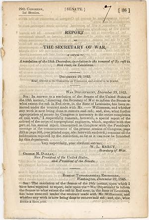
Report of the Secretary of War, in answer to a resolution of the 18th December, in relation to the removal of the raft in Red river, in Louisiana. December 29, 1845. Read, referred to the Committee on Commerce, and ordered to be printed
Sprache: Englisch
Verlag: Ritchie & Heiss, printers, [Washington, D.C.], 1845
Anbieter: Kaaterskill Books, ABAA/ILAB, East Jewett, NY, USA
Verbandsmitglied: ABAA ILAB IOBA
Verkäuferbewertung 5 von 5 Sternen
Erstausgabe
Removed. First edition. 13 pp. Illus. with 1 b/w drawing. 8vo. 29th Congress, 1st session. Senate. Doc. no. 26. Rfats were a contlinual problem for navigation. OCLC locates onlt 4 hard copies: Tulane, Historic New Orleans, LSU, NSU Louisiana. Inked numeral on title else a very good copy.
-
LETTER FROM THE SECRETARY OF WAR COMMUNICATING WITH A RESOLUTION OF THE SENATE, A REPORT OF THE SURVEY, ESTIMATES, &c., OF A ROUTE FROM ST. LOUIS TO THE BIG BEND OF THE RED RIVER (Senate Report: 32nd Congress, First Session. Ex. Doc. No. 49)
Verlag: [Government Printing Office], [Washington DC], 1852
Anbieter: Aardvark Rare Books, EUGENE, OR, USA
Verkäuferbewertung 5 von 5 Sternen
Erstausgabe
Hardcover. Zustand: Very Good. First Edition. Octavo, 8.8 in. x 5.6 in., pp. 59. Illustrated with fold-out map. Rebound in dark brown full calf with blind-stamped frame to front and back; gilt title to front and spine. Newer endpapers. Page one lightly faded. Light tidelines in top margin of all pages, and to edge of folded map. Seven inch closed tear to map. Map condition: Good Plus. From Page 1: "In compliance with the resolution of the Senate of the 11th December last, I have the honor to transmit, herewith, the report of the survey, estimates, &c, of a route from St. Louis to the Big Bend of Red river, made under the direction of the Topographical Bureau, by Joshua Barney. Very respectfully, your obediant servant, C.M. Conrad, Secretary of War." Also from Page 1: "Sir: I have the honor to submit the report, estmates and map of the survey of a route for a road from St. Louis to the Big Bend of Red river called for by a resolution of the Senate of the 11th December, 1851. Respectfully, sir, your obediant servant, J.J. Abert, Colonel Corps Topographical Engineers." The report - often refered to as "The Abert Report" - is named for it's engineer, J.J. Abert. The person who penned the words of the report is Joshua Barney (1799/1800 - 1867), an American renowned for creating high-quality maps of American railroads.
-
REPORT FROM THE SECRETARY OF WAR COMMUNICATING, IN COMPLIANCE WITH A RESOLUTION OF THE SENATE, THE REPORT AND MAP OF THE ROUTE OF FROM FORT SMITH, ARKANSAS, TO SANTA FE, NEW MEXICO, MADE BY LIEUTENANT SIMPSON (SENATE REPORT: 31st CONGRESS, FIRST SESSION. EX. DOC. NO. 12)
Verlag: [Government Printing Office], [Washington DC], 1850
Anbieter: Aardvark Rare Books, EUGENE, OR, USA
Verkäuferbewertung 5 von 5 Sternen
Erstausgabe
Hardcover. Zustand: Very Good. First Edition. Octavo, 8.5 in. x 5.75 in., pp. 25. Illustrated with 4 fold-out maps at rear. Original printed wrappers rebound in black morocco (goatskin) with gilt lettering to front and spine. Single border in blind to both boards. Maps condition: Very Good. Presented by Chief of Corps of Topographical Engineers, J.J. Abert, to Geo. W. Crawford, Secretary of War, who then submitted it to Millard Filmore, Vice-President of The United States.
-
MESSAGE FROM THE PRESIDENT OF THE UNITED STATES, IN COMPLIANCE WITH A RESOLUTION OF THE SENATE, COMMUNICATING A REPORT OF AN EXPEDITION LED BY LIEUTENANT ABERT, ON THE UPPER ARKANSAS AND THROUGH THE COUNTRY OF THE CAMANCHE INDIANS, IN THE FALL OF THE YEAR 1845. (Senate Report: 29th Congress, First Session. [438])
Verlag: [Government Printing Office], [Washington DC], 1846
Anbieter: Aardvark Rare Books, EUGENE, OR, USA
Verkäuferbewertung 5 von 5 Sternen
Erstausgabe
Leather-bound. Zustand: Very Good. First Editions. Octavo, 9.2 in. x 5.8 in., pp. 75. Illustrated with eleven lithographic plates, and two fold-out maps. Rebound in dark navy full calf with gilt title to front and spine. Newer endpapers. Light spotting and browning to plates and pages. For research and protection, the large fold-out map has been separated from the binding and is in archival plastic. A touch of browning to map adges. Map condition: Very Good. Howe A10. Sabin 59. From Page 1: "I transmit, herewith, a communication from the Secretary of War [W.L. Marcy] accompanied by a report of an expedition led by Lieutennt Abert, on the Upper Arkansas and through the country of the Comanche Indians, in the Fall of the Year 1845, as requested by a resolution of the Senate of the 9th instant. Washington, June 15, 1846 - James K. Polk" John John James Abert (1788-1863) was an American soldier. He headed the Corps of Topographical Engineers for 32 years, during which time he organized the mapping of the American West.


![Bild des Verkäufers für MESSAGE FROM THE PRESIDENT OF THE UNITED STATES, IN COMPLIANCE WITH A RESOLUTION OF THE SENATE, COMMUNICATING A REPORT OF AN EXPEDITION LED BY LIEUTENANT ABERT, ON THE UPPER ARKANSAS AND THROUGH THE COUNTRY OF THE CAMANCHE INDIANS, IN THE FALL OF THE YEAR 1845. (Senate Report: 29th Congress, First Session. [438]) zum Verkauf von Aardvark Rare Books](https://pictures.abebooks.com/inventory/md/md31945973210.jpg)