Abert j w (9 Ergebnisse)

Verlag: J. Howell
- Hardcover
Anbieter: ThriftBooks-Dallas, Dallas, TX, USAThriftBooks-Dallas
Verkäufer/-in kontaktierenVerkäufer/-in mit 5 SternenZustand: Gebraucht - Befriedigend
EUR 24,33
Versand nach gratisVersand innerhalb von USAAnzahl: 1 verfügbar
Hardcover. Zustand: Good. No Jacket. Missing dust jacket; Pages can have notes/highlighting. Spine may show signs of wear. ~ ThriftBooks: Read More, Spend Less.
Verlag: JOHN HOWELL, 1966
- Hardcover
Anbieter: Books From California, Simi Valley, CA, USABooks From California
Verkäufer/-in kontaktierenVerkäufer/-in mit 4 SternenZustand: Gebraucht - Befriedigend
EUR 29,66
EUR 4,37 VersandVersand innerhalb von USAAnzahl: 1 verfügbar
Hardcover. Zustand: Good.
Verlag: San Francisco, Calif.: John Howell Books, [n.d.]
- Manuskript
Anbieter: Wittenborn Art Books, San Francisco, CA, USAWittenborn Art Books
Verkäufer/-in kontaktierenVerkäufer/-in mit 5 SternenZustand: Gebraucht - Befriedigend
EUR 22,54
EUR 8,75 VersandVersand innerhalb von USAAnzahl: 1 verfügbar
Zustand: Good. Prospectus. 8vo. One folded sheet. [This is a prospectus, not a book]. Designed and printed by Lawton and Alfred Kennedy. Edited by John Galvin.
Sprache: Englisch
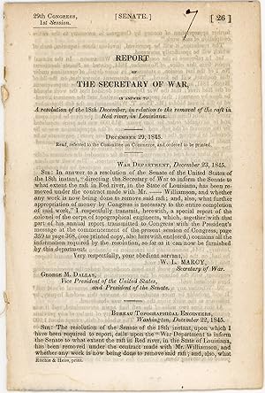
Verlag: Ritchie & Heiss, printers, [Washington, D.C.], 1845
- Erstausgabe
Anbieter: Kaaterskill Books, ABAA/ILAB, East Jewett, NY, USAKaaterskill Books, ABAA/ILAB
Verkäufer/-in kontaktierenVerkäufer/-in mit 5 SternenZustand: Gebraucht
EUR 67,63
EUR 6,13 VersandVersand innerhalb von USAAnzahl: 1 verfügbar
Removed. First edition. 13 pp. Illus. with 1 b/w drawing. 8vo. 29th Congress, 1st session. Senate. Doc. no. 26. Rfats were a contlinual problem for navigation. OCLC locates onlt 4 hard copies: Tulane, Historic New Orleans, LSU, NSU Louisiana. Inked numeral on title else a very good copy.

Verlag: John Howell, San Francisco, 1966
- Hardcover
- Erstausgabe
Anbieter: Between the Covers-Rare Books, Inc. ABAA, Gloucester City, NJ, USABetween the Covers-Rare Books, Inc. ABAA
Verkäufer/-in kontaktierenVerkäufer/-in mit 5 SternenZustand: Gebraucht - Sehr gut
EUR 67,63
EUR 4,81 VersandVersand innerhalb von USAAnzahl: 1 verfügbar
Hardcover. Zustand: Fine. Zustand des Schutzumschlags: Very Good. First edition. Edited by John Galvin. Illustrated from color illustrations and black and white folding maps. Fine in a lightly worn, very good dust jacket with a few edge chips and a small split along the spine. One of 3000 copies printed.
Verlag: John Howell, San Francisco
- Hardcover
Anbieter: Spafford Books (ABAC / ILAB), Regina, SK, KanadaSpafford Books (ABAC / ILAB)
Verkäufer/-in kontaktierenVerkäufer/-in mit 5 SternenZustand: Gebraucht
EUR 63,54
EUR 20,14 VersandVersand von Kanada nach USAAnzahl: 1 verfügbar
1966. (Folio) Very good plus. 116pp. Frontispiece, illus., maps. Mylar wrap slightly torn. Fold-out maps. Illustrations in colour from the author's sketchbooks. Limited to 3000 copies.
Notes of a Military Reconnaissance, from Fort Leavenworth, in Missouri, to San Diego, in California, Including Parts of the Arkansas, Del Norte, and Gila Rivers 13th Congress, 1st Session. Ex. Doc. No. 41. [Includes Reports of Lieut. J. W. Abert, Lieut. Col. P. St. George Cooke, Journal of Capt. A. R. Johnson. ]
Emory, Lieut. Col. W. H. ; Lieut. J. W. Abert; Philip St. George Cooke; Joseph Eggleston Johnston
Verlag: Wendell and Van Benthuysen, Printers, Washington, D. C., 1848
- Hardcover
Anbieter: G. F. Wilkinson Books, member IOBA, GRASS VALLEY, CA, USAG. F. Wilkinson Books, member IOBA
Verkäufer/-in kontaktierenVerkäufer/-in mit 4 SternenVerbandsmitglied: IOBA
Zustand: Gebraucht - Schlecht
EUR 405,77
EUR 3,49 VersandVersand innerhalb von USAAnzahl: 1 verfügbar
Hardcover. Zustand: Poor. Joint split with spine laid down, chipped at edges; rubbing to edges and bumped corners; front endpaper torn; owner signature second endpaper, two bookplates, one for Frederick Wm. Zimmerman, one for Alfred I. Exberg. Hinge starting lower 2 inches at title page, but cord binding holding firm. First fold…ing map of New Mexico with tape repairs to back; degrees of foxing in general to text pages and plates from mild to moderate, occasionaly heavy, yet many pages and plates remain relatively clean. ; Original brown cloth, and paper spine label; 4 sketches; 26 plates; 10 of 12 botanical plates called for, also lacking 2 botanical plates called for in appendix. Abert's report with 23 of 24 plates, lacking Pueblo de Santa Ana; 2 folding maps. Conforms to Wagner-Camp 148: 5. ; 8vo 8" - 9" tall; 614 pages.
 Weitere Bilder
Verlag: Bureau of Topographical Engineers, Washington, 1848
- Hardcover
- Erstausgabe
Anbieter: Glenn Books, ABAA, ILAB, Prairie Village, KS, USAGlenn Books, ABAA, ILAB
Verkäufer/-in kontaktierenVerkäufer/-in mit 5 SternenZustand: Gebraucht
EUR 676,28
EUR 7,00 VersandVersand innerhalb von USAAnzahl: 1 verfügbar
Green Cloth. Zustand: Minor Corner and Edge Wear. No Jacket. First Edition. This is a Senate document from the 30th Congress, 1st Session, Executive No, 23. 132 pages of text material, followed by twenty-four full-page lithographic plates and a large folding map. Plates show very minor brown spotting, confined mainly to the peri…phery. The large folding map has two small closed tears and small areas of paper defect at left margin secondary to binding and folding process. The plates were probably drawn by Abert, lithography by C.B. Graham. The report details Abert's trek from Fort Leavenworth, along the Santa Fe Trail to northern New Mexico, and his return along the Trail. Several pages of Cheyenne vocabulary are included in the report. See Howes A11, Streeter Sale 168, Graff 5, Sabin 57, Wagner-Camp 143 Size: Octavo.
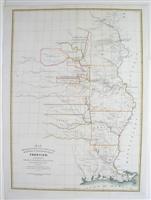
Verlag: United Sates Topographical Bureau, Washington DC, United States, 1837
- Karte
Anbieter: Alexandre Antique Prints, Maps & Books, Toronto, ON, KanadaAlexandre Antique Prints, Maps & Books
Verkäufer/-in kontaktierenVerkäufer/-in mit 4 SternenZustand: Gebraucht - Gut
EUR 676,28
EUR 5,25 VersandVersand von Kanada nach USAAnzahl: 1 verfügbar
Zustand: Very Good. 19th century map showing west of the Mississippi River based on surveys of Washington Hood. It was published in a report of the Secretary of War related to the protection of the western frontiers of the United States., Size : 550x393 (mm), 21.625x15.5 (Inches), Hand Colored.


