A d bache (82 Ergebnisse)

- Softcover
Anbieter: PBShop.store US, Wood Dale, IL, USAPBShop.store US
Verkäufer/-in kontaktierenVerkäufer/-in mit 5 SternenZustand: Neu
EUR 18,40
Versand nach gratisVersand innerhalb von USAAnzahl: 15 verfügbar
PAP. Zustand: New. New Book. Shipped from UK. Established seller since 2000.

- Softcover
Anbieter: PBShop.store US, Wood Dale, IL, USAPBShop.store US
Verkäufer/-in kontaktierenVerkäufer/-in mit 5 SternenZustand: Neu
EUR 18,52
Versand nach gratisVersand innerhalb von USAAnzahl: 15 verfügbar
PAP. Zustand: New. New Book. Shipped from UK. Established seller since 2000.
- Softcover
Anbieter: PBShop.store UK, Fairford, GLOS, Vereinigtes KönigreichPBShop.store UK
Verkäufer/-in kontaktierenVerkäufer/-in mit 5 SternenZustand: Neu
EUR 17,74
EUR 3,86 VersandVersand von Vereinigtes Königreich nach USAAnzahl: 15 verfügbar
PAP. Zustand: New. New Book. Shipped from UK. Established seller since 2000.

- Softcover
Anbieter: PBShop.store US, Wood Dale, IL, USAPBShop.store US
Verkäufer/-in kontaktierenVerkäufer/-in mit 5 SternenZustand: Neu
EUR 24,26
Versand nach gratisVersand innerhalb von USAAnzahl: 15 verfügbar
PAP. Zustand: New. New Book. Shipped from UK. Established seller since 2000.
- Softcover
Anbieter: PBShop.store UK, Fairford, GLOS, Vereinigtes KönigreichPBShop.store UK
Verkäufer/-in kontaktierenVerkäufer/-in mit 5 SternenZustand: Neu
EUR 24,31
EUR 3,86 VersandVersand von Vereinigtes Königreich nach USAAnzahl: 15 verfügbar
PAP. Zustand: New. New Book. Shipped from UK. Established seller since 2000.

- Softcover
Anbieter: PBShop.store US, Wood Dale, IL, USAPBShop.store US
Verkäufer/-in kontaktierenVerkäufer/-in mit 5 SternenZustand: Neu
EUR 35,41
Versand nach gratisVersand innerhalb von USAAnzahl: 15 verfügbar
PAP. Zustand: New. New Book. Shipped from UK. Established seller since 2000.
- Softcover
Anbieter: PBShop.store UK, Fairford, GLOS, Vereinigtes KönigreichPBShop.store UK
Verkäufer/-in kontaktierenVerkäufer/-in mit 5 SternenZustand: Neu
EUR 30,07
EUR 7,93 VersandVersand von Vereinigtes Königreich nach USAAnzahl: 15 verfügbar
PAP. Zustand: New. New Book. Shipped from UK. Established seller since 2000.

- Hardcover
- Erstausgabe
Anbieter: Victoria Bookshop, BERE ALSTON, DEVON, Vereinigtes KönigreichVictoria Bookshop
Verkäufer/-in kontaktierenVerkäufer/-in mit 3 SternenZustand: Gebraucht - Gut
EUR 30,69
EUR 11,55 VersandVersand von Vereinigtes Königreich nach USAAnzahl: 1 verfügbar
Hardcover. Zustand: Very Good. Zustand des Schutzumschlags: Very Good. First Edition. Book.

Verlag: Robert Armstrong, Washington, D.C., 1852
- Hardcover
Anbieter: Carothers and Carothers, Albany, CA, USACarothers and Carothers
Verkäufer/-in kontaktierenVerkäufer/-in mit 5 SternenZustand: Gebraucht - Befriedigend
EUR 36,07
EUR 6,57 VersandVersand innerhalb von USAAnzahl: 1 verfügbar
Hardcover. Zustand: Good. No Jacket. 559, v pages. This is a sound copy of the text volume. Publisher's blind-stamped cloth good, wear to edges, foot of spine worn and slightly frayed, loss of ca one inch from head of spine, with a repair by colored tape, rhodent damage to foot of rear panel and to foot of textblock; inner hinge…s sturdy, "compliments of A.D. Bache" printed on a small slip and affixed to front pastedown, contents moderately foxed but otherwise unmarked, a tear with minor loss to the lower fore-corner of the final two leaves. 860 grams.
- Hardcover
Anbieter: Studibuch, Stuttgart, DeutschlandStudibuch
Verkäufer/-in kontaktierenVerkäufer/-in mit 5 SternenZustand: Gebraucht - Befriedigend
EUR 6,99
EUR 62,30 VersandVersand von Deutschland nach USAAnzahl: 1 verfügbar
hardcover. Zustand: Befriedigend. 336 Seiten; 9780246115072.4 Gewicht in Gramm: 1.

- Softcover
Anbieter: moluna, Greven, Deutschlandmoluna
Verkäufer/-in kontaktierenVerkäufer/-in mit 5 SternenZustand: Neu
EUR 21,80
EUR 48,99 VersandVersand von Deutschland nach USAAnzahl: Mehr als 20 verfügbar
Zustand: New. KlappentextrnrnUnlike some other reproductions of classic texts (1) We have not used OCR(Optical Character Recognition), as this leads to bad quality books with introduced typos. (2) In books where there are images such as portraits, maps, sketc.

- Softcover
Anbieter: moluna, Greven, Deutschlandmoluna
Verkäufer/-in kontaktierenVerkäufer/-in mit 5 SternenZustand: Neu
EUR 22,59
EUR 48,99 VersandVersand von Deutschland nach USAAnzahl: Mehr als 20 verfügbar
Zustand: New.

- Softcover
Anbieter: moluna, Greven, Deutschlandmoluna
Verkäufer/-in kontaktierenVerkäufer/-in mit 5 SternenZustand: Neu
EUR 34,16
EUR 48,99 VersandVersand von Deutschland nach USAAnzahl: Mehr als 20 verfügbar
Zustand: New. KlappentextrnrnUnlike some other reproductions of classic texts (1) We have not used OCR(Optical Character Recognition), as this leads to bad quality books with introduced typos. (2) In books where there are images such as portraits, maps, sketc.

- Hardcover
Anbieter: moluna, Greven, Deutschlandmoluna
Verkäufer/-in kontaktierenVerkäufer/-in mit 5 SternenZustand: Neu
EUR 33,31
EUR 48,99 VersandVersand von Deutschland nach USAAnzahl: Mehr als 20 verfügbar
Gebunden. Zustand: New.
- Softcover
Anbieter: Buchpark, Trebbin, DeutschlandBuchpark
Verkäufer/-in kontaktierenVerkäufer/-in mit 5 SternenZustand: Gebraucht
EUR 12,70
EUR 105,00 VersandVersand von Deutschland nach USAAnzahl: 1 verfügbar
Zustand: Hervorragend. Zustand: Hervorragend | Sprache: Englisch | Produktart: Bücher | Keine Beschreibung verfügbar.
Verlag: (Washington, 1863
Anbieter: Zentralantiquariat Leipzig GmbH, Leipzig, DeutschlandZentralantiquariat Leipzig GmbH
Verkäufer/-in kontaktierenVerkäufer/-in mit 5 SternenZustand: Gebraucht
EUR 23,00
EUR 48,00 VersandVersand von Deutschland nach USAAnzahl: 1 verfügbar
4°. M. 1 Kte. u. 3 lith. Taf. VI, 82 S., 7 Bl. Pp. (Smiths. Contr. to Knowbdge. 166). Sprache: Englisch 0 gr.
Verlag: Pudney & Russell, New York, 1859
- Softcover
Anbieter: Main Street Fine Books & Mss, ABAA, Galena, IL, USAMain Street Fine Books & Mss, ABAA
Verkäufer/-in kontaktierenVerkäufer/-in mit 5 SternenZustand: Gebraucht
EUR 112,73
EUR 5,25 VersandVersand innerhalb von USAAnzahl: 1 verfügbar
Paperback. 8vo. Wrappers. 13pp. Very good. Slight age toning and soiling, mainly to outer wrappers; largely disbound. The noted physicist (1806-67), superintendent of the U.S. Coast Survey, relays to the president of the New York Chamber of Commerce the results of a study on changes in depth that had taken place off the piers in… New York harbor -- decreases caused mainly by city dumping. Not in Sabin.

Verlag: [no publisher], Philadelphia, 1839
- Softcover
- Erstausgabe
Anbieter: Between the Covers-Rare Books, Inc. ABAA, Gloucester City, NJ, USABetween the Covers-Rare Books, Inc. ABAA
Verkäufer/-in kontaktierenVerkäufer/-in mit 5 SternenZustand: Gebraucht - Gut bis sehr gut
EUR 202,91
EUR 4,82 VersandVersand innerhalb von USAAnzahl: 1 verfügbar
Softcover. Zustand: Near Fine. First edition. Octavo. 52pp., folding chart. Brown printed wrappers. A little soiling and light wear, the chart is a little misfolded (probably by the printer, as it has no other fold marks.) *OCLC* seems to locate six copies over a few records with similar but different paginations (50, 52, & 54 p…ages).
 Weitere Bilder
Verlag: Communicated by authority of the Treasury Dept, (Washington, DC), 1857
- Softcover
- Erstausgabe
Anbieter: Bartleby's Books, ABAA, Chevy Chase, MD, USABartleby's Books, ABAA
Verkäufer/-in kontaktierenVerkäufer/-in mit 5 SternenZustand: Gebraucht
EUR 338,18
EUR 7,00 VersandVersand innerhalb von USAAnzahl: 1 verfügbar
First separate edition, extracted from the American Journal of Science and Arts, vol. XXIII, second series, Jan., 1857. 8vo. 17 pp. Tables, two folding plates (lithographed by J. Bien, New York), one showing the effects of tides along the Gulf Coast from Texas to Florida. "On the Gulf Coast, the tides are small, and therefore ea…sily influenced by extraneous circumstances, and, as a rule, on more than two thirds of the coast the semi-diurnal tides are very small, and in fact are masked by the diurnal tides." Inscribed at the head of the front wrapper "Chester County Cabinet, / from Prof. A.D. Bache. / April 7, 1857." Sabin 2588. OCLC locates two copies (Harvard, Library Company). Very good. Orig. plain tan wrappers. (#7571).

Verlag: U. S. Coast Survey Office, Washington, 1853
Anbieter: Argosy Book Store, ABAA, ILAB, New York, NY, USAArgosy Book Store, ABAA, ILAB
Verkäufer/-in kontaktierenVerkäufer/-in mit 5 SternenZustand: Gebraucht
EUR 90,18
EUR 5,25 VersandVersand innerhalb von USAAnzahl: 1 verfügbar
unbound. Sea chart. Uncolored lithograph. Sheet measures 15" x 18.5". Small 1853 U.S. Coast Survey nautical chart or sea chart of Shoalwater Bay in the Washington Territory. Depicts the area around Leadbetter Point, Toke point, and Bay Center and the Palux River. The map offers detailed nautical information essential for navigat…ion, including tide data, soundings, and sailing directions. The map features text, relief shown by hachures, and depths indicated by soundings and shading. In good condition with some creasing and uneven left margin. Some light toning along folds. The U.S. Coast and Geodetic Survey was first established in 1807 and is the oldest scientific organization in the U.S Government. After the Civil War, the bureau took responsibility for mapping and conducting geodetic surveys of the the interior of the expanding country. Over the course of the 19th century, the survey worked closely with the U.S. Navy to produce sea charts of the country's coasts, harbors, and waters that could serve scientific as well as military functions. The first superintendent, Ferdinand Hassler, set the foundation for the Survey's rigorous scientific standards, employing advanced techniques and a labor-intensive triangulation system to ensure accuracy. His successor, Alexander Dallas Bache, expanded the Survey's influence, securing funding and overseeing its most critical work from 1843 to 1865. The organization evolved into the U.S. Coast and Geodetic Survey in 1878 and is now part of NOAA as the National Geodetic Survey.
Verlag: Government Printing Office, Washington, 1851
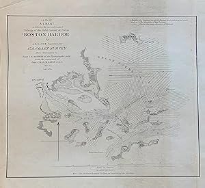
Anbieter: Argosy Book Store, ABAA, ILAB, New York, NY, USAArgosy Book Store, ABAA, ILAB
Verkäufer/-in kontaktierenVerkäufer/-in mit 5 SternenZustand: Gebraucht
EUR 90,18
EUR 5,25 VersandVersand innerhalb von USAAnzahl: 1 verfügbar
unbound. Sea chart. Uncolored engraving. Image measures 7.5 x 9 inches. This fantastically detailed sea chart issued by the United States Coast Survey in 1851 beautifully depicts the Boston Harbor and tidal currents. It extends as far north as Nahant, as far south as Petticks Island, to Hull, and as far west as Boston.The map is… in good condition, with minor toning. Alexander Dallas Bache (1806-1867) was an incredibly prolific surveyor, who worked as the superintendent of the United States Coast Survey from 1843 to 1865. Over the course of the 19th century, the survey worked closely with the U.S. Navy to produce sea charts of the country's waters that could serve scientific as well as military functions. This crisp and bright sea chart of the waters around Boston Harbor is a beautiful document of this historical effort, and one of few maps that he personally partook in surveying.
- Hardcover
Anbieter: Herman H. J. Lynge & Søn ILAB-ABF, Copenhagen, DänemarkHerman H. J. Lynge & Søn ILAB-ABF
Verkäufer/-in kontaktierenVerkäufer/-in mit 4 SternenZustand: Gebraucht
EUR 55,11
EUR 42,00 VersandVersand von Dänemark nach USAAnzahl: 1 verfügbar
(Newhaven), 1860. Contemp. clothbacked boards. Titlelabel with gilt lettering. Stamp on title-page. Offprint from "Am. Journ. of Science and Arts, Vol. XXX, Nov. 1860". 17 pp., 2 folded engraved plates, 1 large folded engraved map.

Verlag: U.S. Coast Survey / U.S. Navy, United States, 1850
- Karte
Anbieter: Alexandre Antique Prints, Maps & Books, Toronto, ON, KanadaAlexandre Antique Prints, Maps & Books
Verkäufer/-in kontaktierenVerkäufer/-in mit 4 SternenZustand: Gebraucht
EUR 112,73
EUR 5,25 VersandVersand von Kanada nach USAAnzahl: 1 verfügbar
Zustand: Excellent. Size : 232x175 (mm), 9.125x6.875 (Inches), Hand Colored in Outline.

Verlag: U.S. Coast Survey / U.S. Navy, United States, 1850
- Karte
Anbieter: Alexandre Antique Prints, Maps & Books, Toronto, ON, KanadaAlexandre Antique Prints, Maps & Books
Verkäufer/-in kontaktierenVerkäufer/-in mit 4 SternenZustand: Gebraucht
EUR 112,73
EUR 5,25 VersandVersand von Kanada nach USAAnzahl: 1 verfügbar
Zustand: Excellent. Size : 131x178 (mm), 5.125x7 (Inches), Hand Colored in Outline.

Verlag: U.S. Coast Survey / U.S. Navy, United States, 1850
- Karte
Anbieter: Alexandre Antique Prints, Maps & Books, Toronto, ON, KanadaAlexandre Antique Prints, Maps & Books
Verkäufer/-in kontaktierenVerkäufer/-in mit 4 SternenZustand: Gebraucht
EUR 112,73
EUR 5,25 VersandVersand von Kanada nach USAAnzahl: 1 verfügbar
Zustand: Excellent. Size : 200x141 (mm), 7.875x5.5 (Inches), Hand Colored in Outline.

Verlag: U.S. Coast Survey / U.S. Navy, United States, 1850
- Karte
Anbieter: Alexandre Antique Prints, Maps & Books, Toronto, ON, KanadaAlexandre Antique Prints, Maps & Books
Verkäufer/-in kontaktierenVerkäufer/-in mit 4 SternenZustand: Gebraucht
EUR 112,73
EUR 5,25 VersandVersand von Kanada nach USAAnzahl: 1 verfügbar
Zustand: Excellent. Size : 140x202 (mm), 5.5x8 (Inches), Hand Colored in Outline.

Verlag: U.S. Coast Survey / U.S. Navy, United States, 1850
- Karte
Anbieter: Alexandre Antique Prints, Maps & Books, Toronto, ON, KanadaAlexandre Antique Prints, Maps & Books
Verkäufer/-in kontaktierenVerkäufer/-in mit 4 SternenZustand: Gebraucht
EUR 112,73
EUR 5,25 VersandVersand von Kanada nach USAAnzahl: 1 verfügbar
Zustand: Excellent. Size : 229x192 (mm), 9x7.5 (Inches), Hand Colored in Outline.

U.S. coast survey. Reconnaissance of the Western Coast of the United States from Gray's Harbor to the Entrance of Admiralty Inlet.
Washington State, map and views of the coast - Bache, A. D. and James Alden:
Verlag: USA, Woodward & Smith, 1853., 1853
Anbieter: Antiquariat Thomas Rezek, München, DeutschlandAntiquariat Thomas Rezek
Verkäufer/-in kontaktierenVerkäufer/-in mit 5 SternenZustand: Gebraucht
EUR 80,00
EUR 44,00 VersandVersand von Deutschland nach USAAnzahl: 1 verfügbar
circa 40,5 x 48 cm. 1 leaf several folds With a map of the west coast from Gray s harbor to the Strait of Juan de Fuca. To the right four views of the coast line. - Minor browning, folds.


