Gesamtpreis (1 Artikel Artikel):
Versandziel:

VISSCHER,N (14 Ergebnisse)
Direkt zu den wichtigsten Suchergebnissen
Produktart
- Alle Produktarten
- Bücher (7)
- Magazine & Zeitschriften
- Comics
- Noten
- Kunst, Grafik & Poster (1)
- Fotografien
- Karten (6)
-
Manuskripte &
Papierantiquitäten
Zustand
- Alle
- Neu
- Antiquarisch/Gebraucht
Einband
- alle Einbände
- Hardcover
- Softcover (1)
Weitere Eigenschaften
- Erstausgabe
- Signiert
- Schutzumschlag
- Angebotsfoto (12)
Land des Verkäufers
Verkäuferbewertung
-
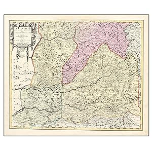
LA CASTILLE PROPRE OU VIEILLE, ET LA NOUVELLE, AVEC L'ESTREMADURE CASTILLANE DRESSÉ SUR LES MEMOIRES DE RODRIGO MENDES SILVA, ET AUTRES
Erscheinungsdatum: 1690
Zustand: Muy bien. Materia:Cartografía antigua del siglo XVII. Castilla Publicación: Amsterdam, cerca del ańo 1690. Descripción: En el ángulo superior izquierdo: cartela rodeada de escudos, banderas y elementos bélicos conteniendo título, autor y escalas gráficas. En la parte inferior una guirnalda flanquea los signos convencionales. Relieve representado por dibujo de perfiles de montańa abatidos, denominados los principales sistemas orográficos. Planimetría: núcleos de población, representados por círculos y por dibujo de agrupación de edificios excepto Madrid, red de carreteras, puentes y líneas de división de reinos. La hidrografía muestra la red principal, con denominación y dibujo de aguas los ríos más importantes. Comprende: Reinos de Castilla la Nueva, Castilla la Vieja y Extremadura. Técnica: Grabado calcográfico. / Reverso: Sin texto. Mapa coloreado a mano con acuarela en la época. Conservación: Buen estado de conservación. Impreso en papel grueso y fuerte de gran calidad, muy limpio. Medidas: 450 x 540 mm. Dimensión total: 500 x 600 mm. BS1.
-
Dominii Frisiae Tabula, inter Flevum et Lavicam
Verlag: Amsterdam, 1684
Anbieter: Alexandre Antique Prints, Maps & Books, Toronto, ON, Kanada
Bewertung:

Karte
A highly decorative cartouche with Royal crown and a crest with lions is present in the lower left. Small vignette image of angles is located in the lower right., Size : 480x560 (mm), 18.875x22 (Inches), Original Outline Coloring Good, two small tears along the lower margin have been repaired, lower portion of the central fold reinforced.
-
Rhenolandia Amstelandia et Circumjacentia aliquot Territoria cum Aggeribus?
Verlag: Amsterdam, 1688
Anbieter: Alexandre Antique Prints, Maps & Books, Toronto, ON, Kanada
Bewertung:
Karte
Zustand: Very good. Large decorative cartouche in the upper right. The map depicts the greater area of Amsterdam, Haerlen, Leyden, and Gravenhage., Size : 470x570 (mm), 18.5x22.375 (Inches), Original Hand Coloring.
-
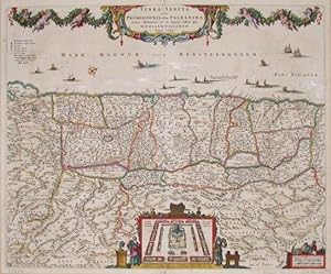
Terra Sancta sive Promissionis, olim Palestina
Verlag: Visscher, N., 1659
Israel / Palestine."Terra Sancta sive Promissionis, olim Palestina". copperplate engraving published by N. Visscher, 1659. Original hand colouring. With ornamental title-cartouche held by cherubs in a garland of fruits. A plan of the desert camp of the Isrealites in the lower part of the map. There are Moses and Aaron with the Golden Altar on the left and the Golden Table on the right side of the map. 46:56 cm (18.1 x 22 inch.). West-oriented map.
-
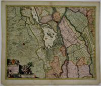
Hollandiae Pars Meridionalior vulgo Zuyd-Holland
Verlag: Amsterdam, 1684
Anbieter: Alexandre Antique Prints, Maps & Books, Toronto, ON, Kanada
Bewertung:
Karte
Size : 470x570 (mm), 18.5x22.375 (Inches), Original Hand Coloring Very Good, some minor tears along the margins not affecting the plate.
-
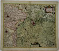
Mechlinia Dominium et Aerschot
Verlag: Amsterdam, 1684
Anbieter: Alexandre Antique Prints, Maps & Books, Toronto, ON, Kanada
Bewertung:
Karte
Size : 470x570 (mm), 18.5x22.375 (Inches), Original Hand Coloring Good, lower portion of central fold has been reinforced, small tear along lower margin not affecting the image has been repaired.
-
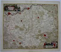
Limburgi Ducatus et Comitatus Valckenburgi
Verlag: Amsterdam, 1695
Anbieter: Alexandre Antique Prints, Maps & Books, Toronto, ON, Kanada
Bewertung:
Karte
Size : 470x570 (mm), 18.5x22.375 (Inches), Original Hand Coloring Very Good, lower central fold reinforced.
-

Indiae Orientalis nec non Insularum Adiacentium Nova Descriptio".
Anbieter: Antiquariaat A. Kok & Zn. B.V., Amsterdam, Niederlande
Bewertung:

Contemp. handcol. engr. map [47.3 x 56.5 cm (platemark)], pbld [Amst., c. 1696]. Koeman, Atlantis Neerlandici III, p.182, no. [183]. Beautiful handcoloured attractive map of the East Indies, extending from India to New Guinea. The northern coastline of Australia is shown in the l.r.c., as well as the southern part of Japan in the u.r.c. Tittle within allegorical cartouche. Fine copy.
-
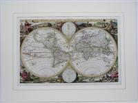
Orbis Terrarum Tabula
Verlag: Amsterdam, 1663
Anbieter: Alexandre Antique Prints, Maps & Books, Toronto, ON, Kanada
Bewertung:
Karte
Zustand: Excellent. Dutch Text on versoA second world map was prepared by Nicholas Visscher for insertion in a Dutch bible., Size : 305x470 (mm), 12x18.5 (Inches), Hand Colored, 0.
-
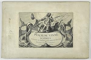
Piscium vivae icones. Inventae ab Adriano Collardo et excusae a Nicolao Ioannis Visscher.
Anbieter: Antiquariaat Schierenberg, Amsterdam, Niederlande
Bewertung:
[Amsterdam, N. J. Visscher], 1634. Oblong folio (20.1 x 30.3 cm). Engraved title page or frontispiece with title in cartouche, and 19 finely engraved plates [together numbered (1)-20], each with a print-size of 12.5 x 19.0 cm. Bound without covers. = A fine suite of fishes, marine mammals and several crustaceans, engraved by the Dutch engraver, mapmaker and publisher Claes Jansz Visscher (1587-1652), after Adriaen Collaert. Visscher (Fisher) was also known as Nicolas Joannes Piscator - an apt name, given the subject of this work. A coherent suite with strong impressions. Often such suites are found trimmed to the border and mounted; this one, however, has fine, broad margins, even wider than those of the copy in the British Museum (see the British Museum Research Collection online). In contrast with Collaert, who placed his fish in landscapes - as if stranded - Visscher "freed" his subject from picturesque settings and clutterings of irrelevant artefacts, and made the images more suitable for comparison and identification. The individual fishes, whales, crabs, turtles, and other animals (including a crocodile, and hermit crab), have captions with their Latin and Dutch names. The title page shows a fisherman in an allegorical setting, and the text "van Godt alleen" (from God only). Dean reports a copy with 26 plates and "without descriptions": evidently this is at odds with all other sources (e.g., OCLC). We found only two auction records in the last 70 years. Old ink inscription in the left margin of the title; title leaf and last plate edges slightly soiled, frayed, and partly chipped in the margins, much less frayed - if at all - in the others, and all as to be expected in such an unusually broad-margined copy. In all, a truly well-preserved suite. Rare. Dean III, p. 327; Nissen ZBI, 925 (under Collaert).
-
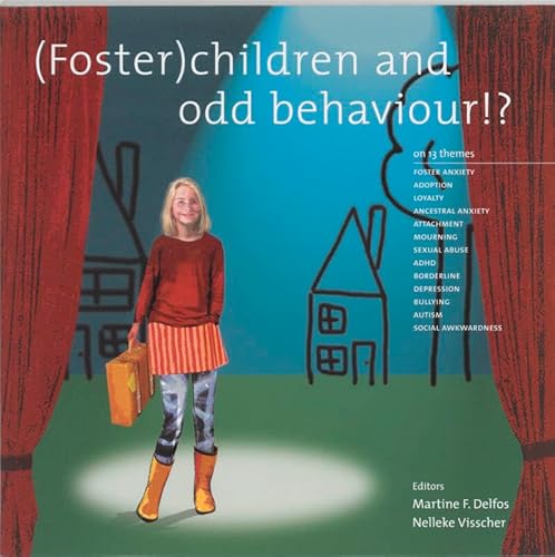
(Foster)Children and Odd Behaviour: On 13 Themes
Verlag: Swp, 2001
ISBN 10: 9066654260ISBN 13: 9789066654266
Buch
Zustand: Poor. This is an ex-library book and may have the usual library/used-book markings inside.This book has soft covers. In poor condition, suitable as a reading copy. Please note the Image in this listing is a stock photo and may not match the covers of the actual item,450grams, ISBN:9789066654266.
-
Kartengröße 49 x 57 cm. Große Karte der Gegend um Ličge, mit den Orten Huy, s'Gravendal Dalem, Verviers, Dur Buy und Linburg. - Mittelfalz hinterlegt, am Rand gering fleckig. Gut erhalten.
-
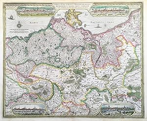
Tabula Electoratus Brandenburgici, Meckelenburgi, et maxime partis Pomeraniae, ex variis, famosissimisq(ue) Auctoribus summa studio concinnata.
Verlag: Amsterdam: Visscher dat. ,, 1633
Anbieter: Antiquariat Ruthild Jäger, Lueneburg, Deutschland
Bewertung:

Kunst / Grafik / Poster
Altkolorierte Kupferstichkarte m. Bordüre (von A. Goos), 55 x 45 cm (einige kleine Stellen im weißen Papierrand unsichtbar ergänzt, sonst sehr gut erhalten). * Campbell, Visscher 18 (Taf.V); Hollstein XXXVIII, 252; Blühm/Jäger: Stettin 6 (Ausg. 1629). Die sehr dekorative, farbfrische Karte zeigt die gesamte Mark Brandenburg, ganz Mecklenburg und Pommern (bis zur Linie Rügenwalde-Neustettin). In den vier Ecken je eine schöne, ausgemalte Stadtansicht in ovaler Umrandung (je 4,5 x 14 cm) von: Stettin, Stralsund, Rostock und Frankfurt/Oder. (#4975AG) (Es sind von dieser Karte Datierungen mit 1629, 1630 und 1633 bekannt). Sprache: Deutsch.
-
![Bild des Verkäufers für [Engraving and etching, gravure en ets] Leopoldus de Eerste door G.G. Roomsch Keijser Gekooren (set: Nineteen equestrian portraits); published ca. 1689 zum Verkauf von Antiquariaat Arine van der Steur / ILAB](https://pictures.abebooks.com/inventory/md/md30824109286.jpg)
Portrait of Emperor (keizer) Leopold I (1640-1705) riding a ramping horse. Titled below: "Leopoldus de Eerste door G.G. Roomsch Keijser Gekooren", further inscribed at the bottom of the figure: "door Pieter Stevensz." and lettered with address at the very bottom of the impression: "by Nicolaus Visscher met Privilegie vande H.H. Stat: Gen:l". On verso in pen and black ink: "Ob. 1705", thus referring to the death of the emperor. From a set of nineteen equestrian portraits. ca. 1689.Leopold I, was bijna een halve eeuw heerser als Rooms-Duitse keizer, koning van Hongarije en koning van Bohemen. Leopold was een lid van het huis Habsburg als de tweede zoon van keizer Ferdinand III en zijn eerste vrouw, Maria Anna van Spanje. Engraving and etching on paper, trimmed within plate mark; total: 231 x 154 mm; some dirt and smudges, however very sharp impression. Mounted on paper mat in passepartout. Hollstein 10.