Gesamtpreis (1 Artikel Artikel):
Versandziel:

1832 young (3 Ergebnisse)
Direkt zu den wichtigsten Suchergebnissen
Suchfilter
Produktart
- Alle Product Types
- Bücher (2)
- Magazine & Zeitschriften (Keine weiteren Ergebnisse entsprechen dieser Verfeinerung)
- Comics (Keine weiteren Ergebnisse entsprechen dieser Verfeinerung)
- Noten (Keine weiteren Ergebnisse entsprechen dieser Verfeinerung)
- Kunst, Grafik & Poster (Keine weiteren Ergebnisse entsprechen dieser Verfeinerung)
- Fotografien (Keine weiteren Ergebnisse entsprechen dieser Verfeinerung)
- Karten (1)
- Manuskripte & Papierantiquitäten (Keine weiteren Ergebnisse entsprechen dieser Verfeinerung)
Zustand Mehr dazu
- Neu (1)
- Wie Neu, Sehr Gut oder Gut Bis Sehr Gut (1)
- Gut oder Befriedigend (Keine weiteren Ergebnisse entsprechen dieser Verfeinerung)
- Ausreichend oder Schlecht (Keine weiteren Ergebnisse entsprechen dieser Verfeinerung)
- Wie beschrieben (1)
Einband
Weitere Eigenschaften
- Erstausgabe (1)
- Signiert (Keine weiteren Ergebnisse entsprechen dieser Verfeinerung)
- Schutzumschlag (Keine weiteren Ergebnisse entsprechen dieser Verfeinerung)
- Angebotsfoto (3)
Sprache (2)
Preis
- Beliebiger Preis
- Weniger als EUR 20 (Keine weiteren Ergebnisse entsprechen dieser Verfeinerung)
- EUR 20 bis EUR 45
- Mehr als EUR 45
Gratisversand
- Kostenloser Versand nach USA (Keine weiteren Ergebnisse entsprechen dieser Verfeinerung)
Land des Verkäufers
Verkäuferbewertung
-

Proceedings of the National Republican Convention of Young Men: Which Assembled in the City of Washi
EUR 21,84
EUR 48,99 Versand
Versand von Deutschland nach USAAnzahl: Mehr als 20 verfügbar
In den WarenkorbKartoniert / Broschiert. Zustand: New.
-
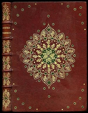
Werther
Verlag: Published Bruxelles, Editions La Boétie, Octobre . 1944., 1944
Anbieter: Little Stour Books PBFA Member, Canterbury, Vereinigtes Königreich
Verbandsmitglied: PBFA
Verkäuferbewertung 5 von 5 Sternen

EUR 296,70
EUR 34,57 Versand
Versand von Vereinigtes Königreich nach USAAnzahl: 1 verfügbar
In den WarenkorbZustand: Near Fine. Hard back binding in stunning full burgundy leather covers, raised bands with gilt title, author lettering and gilt designs to the spine, magnificent hand tooled symmetrical gilt and scarlet design and green polka dots to the front and rear covers, pastel pink and purple curl end papers. Quarto 10'' x 8''. 1500 copies on fine cartridge paper, this is copy No. 1382. Contains 148 [i] printed pages of French text with two tone illustrations throughout. One small area of rubbing to the front cover and in very near Fine condition. Member of the P.B.F.A. FRANCE [Literature & History).
-

Mexico and Guatimala.
Erscheinungsdatum: 1832
Anbieter: Geographicus Rare Antique Maps, Brooklyn, NY, USA
Verbandsmitglied: ABAA ESA ILAB
Verkäuferbewertung 4 von 5 Sternen

Karte Erstausgabe
1st Edition. Good. Moderate foxing. Size 3.5 x 5.5 Inches. A masterwork of small-scale engraving, this is J. H. Young's 1832 map of Mexico and Central America, which appeared in Henry Carey and Isaac Lea's Family Cabinet Atlas . It depicts the region in the wake of the collapse of Spain's American empire and on the eve of the westward expansion of the United States of America. A Closer Look Coverage extends from the Pacific Northwest, here as 'New Albion,' south through Panama and east to Haiti. Copious detail is provided on the geography of Mexico and Central America, including the labeling of individual provinces of the United Mexican States, all the more impressive given the map's small scale. Some common cartographic errors of the era, such as the Buenaventura River, are retained. Similarly, 'West Florida' is anachronistically maintained. Texas appears as a province of Mexico. At this time, the Mexican government encouraged immigration to Texas despite its inability to prevent conflict with Native Americans, disputes over several issues including slavery, and a failed secession movement in 1826 - 1827. These lingering problems would come to the fore a few years later with the outbreak of the Texas Revolution. 'Guatimala' retains the borders of the defunct Spanish Captaincy General of Guatemala, but a more accurate reflection of the political situation is demonstrated with the numeric labels. Still, uncertainty remained over borders, particularly around Belize ('Bazlie' here), resulting in Belize (City) being located in Mexico, outside of Belize itself. Publication History and Census This map appeared as Plate 90 in the 1832 (first) edition of Henry Carey and Isaac Lea's 1832 Family Cabinet Atlas . Young had engraved maps of this region as far back as 1825, in Grigg's American Atlas , which may explain some of the anachronisms noted above. The present map is not cataloged in the holdings of any institution in the OCLC and is scarce to the market, while the entire atlas (OCLC 276123103, 276123103) is quite rare, only appearing in four institutional collections.