1772 paris (104 Ergebnisse)

Porträt. Brustbild. Original - Lithographie von Delpech, 27 x 17 cm, ca. 1830.
Désaugiers, Marc-Antoine-Madeleine (1772 Fréjus - 1827 Paris; frz. Musiker, Sänger, Chansonnier).
- Kunst / Grafik / Poster
Anbieter: Antiquariat Michael Eschmann, Groß-Gerau, DeutschlandAntiquariat Michael Eschmann
Verkäufer/-in kontaktierenVerkäufer/-in mit 5 SternenZustand: Gebraucht
EUR 45,00
EUR 22,00 VersandVersand von Deutschland nach USAAnzahl: 1 verfügbar
In den Warenkorb0. Sprache: Deutschu.
Sprache: Französisch
Verlag: chés Lattré, rue St Jacques, à la Ville de Bordeaux, 1772
Anbieter: Librairie Rouchaleou, Saint-André-de-Sangonis, FR, FrankreichLibrairie Rouchaleou
Verkäufer/-in kontaktierenVerkäufer/-in mit 5 SternenZustand: Gebraucht - Sehr gut
EUR 1.200,00
EUR 54,00 VersandVersand von Frankreich nach USAAnzahl: 1 verfügbar
In den WarenkorbPas de couverture. Zustand: Très bon. 1 carte gravée entoilée pliée du XVIIIème siècle, dépliante de format 55 x 77 cms (toile saumon de l'époque), repliée au format in 8, en 24 feuillets gravés, avec une table alphabétique des rues, paroisses, collèges, hôpitaux, communautés, hospitaliers, 4 auréoles claires au niveau du bas de… la carte. Carte ornée d'un beau cartouche de titre illustré au blason de la ville de Paris, et finement rehaussé à l'aquarelle à l'époque (scarce map of 18th century, finely colored). Rare '' Carte routière de ville et faubourg de Paris '', carte gravée imprimée sur beau vergé, avec cartouche et contours finement coloriés à l'époque. Jean Lattre. Bel exemplaire.

Verlag: Artist: Bellin Jacques Nicolas ( - 1772 ) Paris ca : 1758, 1703
Anbieter: Antique Sommer& Sapunaru KG, München, DeutschlandAntique Sommer& Sapunaru KG
Verkäufer/-in kontaktierenVerkäufer/-in mit 5 SternenZustand: Gebraucht
EUR 80,00
EUR 45,00 VersandVersand von Deutschland nach USAAnzahl: 1 verfügbar
In den WarenkorbTechnic: Copper print, colorit: colored, condition: Perfect condition, size (in cm): 19,5 x 30,5, Map shows the south part of Vaygach Island in the Arctic Sea, the Yugorsky Strait and partly Russia. Sailing in the Arctic ocean, In June 1594, Linschoten sailed from Texel in the expedition headed by Dutch cartographer Willem Baren…tsz. Three ships intended to enter the Kara Sea, hoping to find the Northeast Passage above Siberia. Nearing Williams Island the crew for the first time encountered a polar bear. After enticing it on board the bear then rampaged and had to be killed. Barentsz approached the west coast of Nova Zembla and heading north, before being forced to turn back in due to danger from large icebergs. The following year they sailed again in a new expedition of six ships, loaded with merchant wares that they hoped to trade with China. The party came across Samoyed ;wild men; but eventually had to turn back when discovering the Kara Sea to be frozen. Linschoten was one of the two crew members to publish journals of the Barentsz expedition. From : Maps for Prevost's L'Histoire Générale des Voyages - 1747-61.

Verlag: Artist: Bellin Jacques Nicolas ( - 1772 ) Paris ca : 1757, 1703
Anbieter: Antique Sommer& Sapunaru KG, München, DeutschlandAntique Sommer& Sapunaru KG
Verkäufer/-in kontaktierenVerkäufer/-in mit 5 SternenZustand: Gebraucht
EUR 80,00
EUR 45,00 VersandVersand von Deutschland nach USAAnzahl: 1 verfügbar
In den WarenkorbTechnic: Copper print, colorit: colored, condition: Perfect condition, size (in cm): 20,5 x 37 cm, Plan of the peruvian town of Paita on the coast of Stanta Fe.

Verlag: Artist: Bellin Jacques Nicolas ( - 1772 ) Paris dated : 1749, 1703
Anbieter: Antique Sommer& Sapunaru KG, München, DeutschlandAntique Sommer& Sapunaru KG
Verkäufer/-in kontaktierenVerkäufer/-in mit 5 SternenZustand: Gebraucht
EUR 110,00
EUR 45,00 VersandVersand von Deutschland nach USAAnzahl: 1 verfügbar
In den WarenkorbTechnic: Copper print, colorit: colored, condition: Very good, size (in cm): 22 x 30,5 cm, Map shows Mongolia and the eastern Mongolia in China. Its area is roughly equivalent with the historical territory of Outer Mongolia, and that term is sometimes used to refer to the current state. It is sandwiched between Russia to the nor…th and China to the south, where it neighbours the Inner Mongolia Autonomous Region. The area of what is now Mongolia has been ruled by various nomadic empires, including the Xiongnu, the Xianbei, the Rouran, the Turkic Khaganate, and others.

Verlag: Artist: Bellin Jacques Nicolas ( - 1772 ) Paris dated : 1749, 1703
Anbieter: Antique Sommer& Sapunaru KG, München, DeutschlandAntique Sommer& Sapunaru KG
Verkäufer/-in kontaktierenVerkäufer/-in mit 5 SternenZustand: Gebraucht
EUR 110,00
EUR 45,00 VersandVersand von Deutschland nach USAAnzahl: 1 verfügbar
In den WarenkorbTechnic: Copper print, colorit: colored, condition: Very good, size (in cm): 21,5,x 30,5, Map shows the city of Turfan in Hsinkiang-Uigur ,north west China. Xinjiang consists of two main geographically, historically, and ethnically distinct regions with different historical names. The Qing dynasty was well aware of the differenc…es between the former Buddhist Mongol area to the north of the Tian Shan and the Turkic Muslim area south of the Tian Shan, and ruled them in separate administrative units at first. However, Qing people began to think of both areas as part of one distinct region called Xinjiang. The Xinjiang conflict is a conflict in China's far-west province of Xinjiang centred around the Uyghurs, a Turkic minority ethnic group who make up the largest group in the region.

Verlag: Artist: Bellin Jacques Nicolas ( - 1772 ) Paris ca : 1758, 1703
Anbieter: Antique Sommer& Sapunaru KG, München, DeutschlandAntique Sommer& Sapunaru KG
Verkäufer/-in kontaktierenVerkäufer/-in mit 5 SternenZustand: Gebraucht
EUR 110,00
EUR 45,00 VersandVersand von Deutschland nach USAAnzahl: 1 verfügbar
In den WarenkorbTechnic: Copper print, colorit: colored, condition: Right margin replaced, size (in cm): 17 x 23, Map shows the island Madagascar.

Verlag: Artist: Bellin Jacques Nicolas ( - 1772 ) Paris ca : 1750, 1703
Anbieter: Antique Sommer& Sapunaru KG, München, DeutschlandAntique Sommer& Sapunaru KG
Verkäufer/-in kontaktierenVerkäufer/-in mit 5 SternenZustand: Gebraucht
EUR 110,00
EUR 45,00 VersandVersand von Deutschland nach USAAnzahl: 1 verfügbar
In den WarenkorbTechnic: Copper print, colorit: original colored, condition: Perfect condition, size (in cm): 22 x 14 cm, Map shows the coast of Senegal with Cap Verde, on seperate map a view of the Island Goree and Cap Emanuel.

Verlag: Artist: Benard/Martinet R ( - 1772 ) Paris ca : 1770, 1751
- Kunst / Grafik / Poster
Anbieter: Antique Sommer& Sapunaru KG, München, DeutschlandAntique Sommer& Sapunaru KG
Verkäufer/-in kontaktierenVerkäufer/-in mit 5 SternenZustand: Gebraucht
EUR 120,00
EUR 45,00 VersandVersand von Deutschland nach USAAnzahl: 1 verfügbar
In den WarenkorbTechnic: Copper print, colorit: colored, condition: Perfect condition, size (in cm): 24 x 16, Original copper engraving by Benard after Martinet from The Enzyclopädia by Denis Diderot und Jean Lerond d'Alembert, Paris 1751 - 1772.
Verlag: Artist: Bellin Jacques Nicolas ( - 1772 ) Paris ca : 1752, 1703
Anbieter: Antique Sommer& Sapunaru KG, München, DeutschlandAntique Sommer& Sapunaru KG
Verkäufer/-in kontaktierenVerkäufer/-in mit 5 SternenZustand: Gebraucht
EUR 120,00
EUR 45,00 VersandVersand von Deutschland nach USAAnzahl: 1 verfügbar
In den WarenkorbTechnic: Copper print, colorit: colored, condition: Perfect condition, size (in cm): 22,5 x 33,5, Map shows partly India with the river Ganges and the cities Benares (Varanasi oder Kashi), Dehli, Agra, Surat, Khambhat, Diu,and tow decorative cartouches. From : Maps for Prevost's L'Histoire Générale des Voyages - 1747-61.

Verlag: Artist: Bellin Jacques Nicolas ( - 1772 ) Paris ca : 1764, 1703
Anbieter: Antique Sommer& Sapunaru KG, München, DeutschlandAntique Sommer& Sapunaru KG
Verkäufer/-in kontaktierenVerkäufer/-in mit 5 SternenZustand: Gebraucht
EUR 120,00
EUR 45,00 VersandVersand von Deutschland nach USAAnzahl: 1 verfügbar
In den WarenkorbTechnic: Copper print, colorit: original colored, condition: Perfect condition, size (in cm): 18 x 25 cm, Map partly showing Sierra Leone with the offshore island "Isle de Scherbro ou de Cerbera" in Africa and a title cartouche.

Verlag: Artist: Benard/Martinet R ( - 1772 ) Paris ca : 1770, 1751
- Kunst / Grafik / Poster
Anbieter: Antique Sommer& Sapunaru KG, München, DeutschlandAntique Sommer& Sapunaru KG
Verkäufer/-in kontaktierenVerkäufer/-in mit 5 SternenZustand: Gebraucht
EUR 120,00
EUR 45,00 VersandVersand von Deutschland nach USAAnzahl: 1 verfügbar
In den WarenkorbTechnic: Copper print, colorit: colored, condition: Perfect condition, size (in cm): 24 x 16, Original copper engraving by Benard after Martinet from The Enzyclopädia by Denis Diderot und Jean Lerond d'Alembert, Paris 1751 - 1772.

Verlag: Artist: Bellin Jacques Nicolas ( - 1772 ) Paris ca : 1770, 1703
Anbieter: Antique Sommer& Sapunaru KG, München, DeutschlandAntique Sommer& Sapunaru KG
Verkäufer/-in kontaktierenVerkäufer/-in mit 5 SternenZustand: Gebraucht
EUR 120,00
EUR 45,00 VersandVersand von Deutschland nach USAAnzahl: 1 verfügbar
In den WarenkorbTechnic: Copper print, colorit: original colored, condition: Perfect condition, size (in cm): 18,5 x 28,5 cm, Map shows the Rio Plata in Uruguay with the cities of Colonia del Sacramento, Montevideo to the bay of Maldonado and Argentinia with the cities Buenos Aires and Punta Piedras.
Porträt. Brustbild im Profil nach links. Radierung (anonym), Blatgröße: 26 x 16 cm, 1873.
Sacchini, Antonio Maria Gasparo (1734 Pozzuoli bei Neapel - 1786 Paris), Opernkomponist. Neapel, München, Stuttgart, 1772-82 in London, 1773 Paris.
- Kunst / Grafik / Poster
Anbieter: Antiquariat Michael Eschmann, Groß-Gerau, DeutschlandAntiquariat Michael Eschmann
Verkäufer/-in kontaktierenVerkäufer/-in mit 5 SternenZustand: Gebraucht
EUR 60,00
EUR 22,00 VersandVersand von Deutschland nach USAAnzahl: 1 verfügbar
In den Warenkorb0. Sprache: Deutschu.

Verlag: Artist: Bellin Jacques Nicolas ( - 1772 ) Paris ca : 1758, 1703
Anbieter: Antique Sommer& Sapunaru KG, München, DeutschlandAntique Sommer& Sapunaru KG
Verkäufer/-in kontaktierenVerkäufer/-in mit 5 SternenZustand: Gebraucht
EUR 140,00
EUR 45,00 VersandVersand von Deutschland nach USAAnzahl: 1 verfügbar
In den WarenkorbTechnic: Copper print, colorit: colored, condition: Perfect condition, size (in cm): 20,5 x 15,5, Map depicts the Mollucces in South East Asia.

Verlag: Artist: Bellin Jacques Nicolas ( - 1772 ) Paris : 1746, 1703
Anbieter: Antique Sommer& Sapunaru KG, München, DeutschlandAntique Sommer& Sapunaru KG
Verkäufer/-in kontaktierenVerkäufer/-in mit 5 SternenZustand: Gebraucht
EUR 140,00
EUR 45,00 VersandVersand von Deutschland nach USAAnzahl: 1 verfügbar
In den WarenkorbTechnic: Copper print, colorit: original colored, condition: Perfect condition, size (in cm): 21 x 29 cm, Map showing part of the coast of Ghana with the town of Axim and a title cartouche.
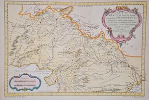
Verlag: ca, 1760
- Kunst / Grafik / Poster
Anbieter: Neusser Buch & Kunst Antiquariat, Neuss, NRW, DeutschlandNeusser Buch & Kunst Antiquariat
Verkäufer/-in kontaktierenVerkäufer/-in mit 4 SternenZustand: Gebraucht
EUR 120,00
EUR 75,00 VersandVersand von Deutschland nach USAAnzahl: 1 verfügbar
In den WarenkorbKupferstich, 31 x 21 cm. 37,5 x24 cm. (mit Ornamentcartusche und Maßstab). leichter Wasserrand am ob. Blattrand, sonst gut erhalten. Sprache: Deutschu 0,700 gr.

Verlag: Artist: Bellin Jacques Nicolas ( - 1772 ) Paris ca : 1764, 1703
Anbieter: Antique Sommer& Sapunaru KG, München, DeutschlandAntique Sommer& Sapunaru KG
Verkäufer/-in kontaktierenVerkäufer/-in mit 5 SternenZustand: Gebraucht
EUR 160,00
EUR 45,00 VersandVersand von Deutschland nach USAAnzahl: 1 verfügbar
In den WarenkorbTechnic: Copper print, colorit: original colored, condition: Perfect condition, size (in cm): 22 x 24,5 cm, Map shows the southern part of India with the island of Sri Lanka, formerly Ceylon, with a title cartouche and a mileage scale. From "Histoire Générale des Voyages".

Verlag: Artist: Bellin Jacques Nicolas ( - 1772 ) Paris ca : 1756, 1703
Anbieter: Antique Sommer& Sapunaru KG, München, DeutschlandAntique Sommer& Sapunaru KG
Verkäufer/-in kontaktierenVerkäufer/-in mit 5 SternenZustand: Gebraucht
EUR 160,00
EUR 45,00 VersandVersand von Deutschland nach USAAnzahl: 1 verfügbar
In den WarenkorbTechnic: Copper print, colorit: colored, condition: Perfect condition, size (in cm): 20 x 26,5, Map shows Mosambique with the cities Sofala, Maputo etc. From : Maps for Prevost's L'Histoire Générale des Voyages - 1747-61.

Verlag: Artist: Bellin Jacques Nicolas ( - 1772 ) Paris ca : 1758, 1703
Anbieter: Antique Sommer& Sapunaru KG, München, DeutschlandAntique Sommer& Sapunaru KG
Verkäufer/-in kontaktierenVerkäufer/-in mit 5 SternenZustand: Gebraucht
EUR 160,00
EUR 45,00 VersandVersand von Deutschland nach USAAnzahl: 1 verfügbar
In den WarenkorbTechnic: Copper print, colorit: colored, condition: Perfect condition, size (in cm): 21,5 x 30,5, Map shows the island group Spitzbergen (Svalbard) in the North Atlantic ( Arctic ocean), belonging to Norway. With title cartouche and wind rose.

Verlag: Artist: Bellin Jacques Nicolas ( - 1772 ) Paris ca : 1764, 1703
Anbieter: Antique Sommer& Sapunaru KG, München, DeutschlandAntique Sommer& Sapunaru KG
Verkäufer/-in kontaktierenVerkäufer/-in mit 5 SternenZustand: Gebraucht
EUR 160,00
EUR 45,00 VersandVersand von Deutschland nach USAAnzahl: 1 verfügbar
In den WarenkorbTechnic: Copper print, colorit: original colored, condition: Perfect condition, size (in cm): 22 x 17,5 cm, Map shows the city map and the surroundings of Genoa with title cartouche.

Verlag: Artist: Bellin Jacques Nicolas ( - 1772 ) Paris ca : 1746, 1703
Anbieter: Antique Sommer& Sapunaru KG, München, DeutschlandAntique Sommer& Sapunaru KG
Verkäufer/-in kontaktierenVerkäufer/-in mit 5 SternenZustand: Gebraucht
EUR 160,00
EUR 45,00 VersandVersand von Deutschland nach USAAnzahl: 1 verfügbar
In den WarenkorbTechnic: Copper print, colorit: colored, condition: Perfect condition, size (in cm): 21,5 x 28,5, Map shows the Cape Verde Islands with title cartouche. From: Maps for Prevost's L'Histoire Générale des Voyages - 1747-61.

Verlag: Artist: Bellin Jacques Nicolas ( - 1772 ) Paris ca : 1758, 1703
Anbieter: Antique Sommer& Sapunaru KG, München, DeutschlandAntique Sommer& Sapunaru KG
Verkäufer/-in kontaktierenVerkäufer/-in mit 5 SternenZustand: Gebraucht
EUR 160,00
EUR 45,00 VersandVersand von Deutschland nach USAAnzahl: 1 verfügbar
In den WarenkorbTechnic: Copper print, colorit: colored, condition: Perfect condition, size (in cm): 20,5 x 14,5, Map shows the islands of Sulawesi.

Verlag: Artist: Bellin Jacques Nicolas ( - 1772 ) Paris ca : 1754, 1703
Anbieter: Antique Sommer& Sapunaru KG, München, DeutschlandAntique Sommer& Sapunaru KG
Verkäufer/-in kontaktierenVerkäufer/-in mit 5 SternenZustand: Gebraucht
EUR 160,00
EUR 45,00 VersandVersand von Deutschland nach USAAnzahl: 1 verfügbar
In den WarenkorbTechnic: Copper print, colorit: colored, condition: Perfect condition, size (in cm): 21 x 31, Map shows the norteast part of China with the city of Shenyang and the river Amur ( Hailong Jiang ) going through Russia and China, the russina island Sachalin and a decorative title cartouche. From : Maps for Prevost's L'Histoire Génér…ale des Voyages - 1747-61.

Verlag: Artist: Bellin Jacques Nicolas ( - 1772 ) Paris ca : 1753, 1703
Anbieter: Antique Sommer& Sapunaru KG, München, DeutschlandAntique Sommer& Sapunaru KG
Verkäufer/-in kontaktierenVerkäufer/-in mit 5 SternenZustand: Gebraucht
EUR 160,00
EUR 45,00 VersandVersand von Deutschland nach USAAnzahl: 1 verfügbar
In den WarenkorbTechnic: Copper print, colorit: colored, condition: Perfect condition, size (in cm): 19 x 34,5, The striking map shows the Straits of Magellan with Argentinia and Fireland.

Verlag: Artist: Bellin Jacques Nicolas ( - 1772 ) Paris ca : 1760, 1703
Anbieter: Antique Sommer& Sapunaru KG, München, DeutschlandAntique Sommer& Sapunaru KG
Verkäufer/-in kontaktierenVerkäufer/-in mit 5 SternenZustand: Gebraucht
EUR 160,00
EUR 45,00 VersandVersand von Deutschland nach USAAnzahl: 1 verfügbar
In den WarenkorbTechnic: Copper print, colorit: colored, condition: Perfect condition, size (in cm): 22 x 36 cm, Map shows the Golf of St. Laurence and New Fundland, Canada.

Verlag: Artist: Bellin Jacques Nicolas ( - 1772 ) Paris ca : 1750, 1703
Anbieter: Antique Sommer& Sapunaru KG, München, DeutschlandAntique Sommer& Sapunaru KG
Verkäufer/-in kontaktierenVerkäufer/-in mit 5 SternenZustand: Gebraucht
EUR 160,00
EUR 45,00 VersandVersand von Deutschland nach USAAnzahl: 1 verfügbar
In den WarenkorbTechnic: Copper print, colorit: colored, condition: Perfect condition, size (in cm): 22 x 14,5, Map shows the Fort and harbour city of Kilwa ( Quiloa,;historicaly wtitten) on an island of Tansania, Africa.

Verlag: Artist: Bellin Jacques Nicolas ( - 1772 ) Paris ca : 1740, 1703
Anbieter: Antique Sommer& Sapunaru KG, München, DeutschlandAntique Sommer& Sapunaru KG
Verkäufer/-in kontaktierenVerkäufer/-in mit 5 SternenZustand: Gebraucht
EUR 160,00
EUR 45,00 VersandVersand von Deutschland nach USAAnzahl: 1 verfügbar
In den WarenkorbTechnic: Copper print, colorit: original colored, condition: Perfect condition, size (in cm): 21 x 17, Map shows the Table Bay with Robben Island and the city of Capetown at the Cape of Good Hope with the towns landmark, the Table Mountain in South Africa.

Verlag: Artist: Bellin Jacques Nicolas ( - 1772 ) Paris ca : 1763, 1703
Anbieter: Antique Sommer& Sapunaru KG, München, DeutschlandAntique Sommer& Sapunaru KG
Verkäufer/-in kontaktierenVerkäufer/-in mit 5 SternenZustand: Gebraucht
EUR 160,00
EUR 45,00 VersandVersand von Deutschland nach USAAnzahl: 1 verfügbar
In den WarenkorbTechnic: Copper print, colorit: colored, condition: Very good, size (in cm): 17 x 23, Map shows the islands of Comoro in the indian ocean.


