Verwandte Artikel zu Appalachian Trail, Delaware Water Gap To Schaghticoke...
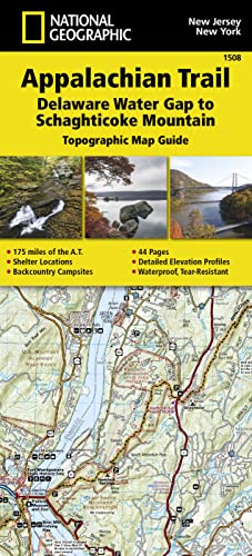
Appalachian Trail, Delaware Water Gap To Schaghticoke Mountain, New Jersey, New York: Trails Illustrated: 1508 (National Geographic Topographic Map Guide)
Zu dieser ISBN ist aktuell kein Angebot verf�gbar.
Alle Exemplare der Ausgabe mit dieser ISBN anzeigen:
Rese�a del editor:
Biograf�a del autor:
� Waterproof � Tear-Resistant � Topographic Map
The Delaware Water Gap to Schaghticoke Mountain Topographic Map Guide makes a perfect traveling companion when traversing the New Jersey and New York sections of the Appalachian Trail (A.T.). The trail through New Jersey and New York is surprisingly rugged, and much more remote than one would imagine given its proximity to large population centers. For 160 miles the trail follows long mountain ridges; travels across bogs, wetlands, and broad river valleys; and meanders through numerous state parks, forests, and national park land.
Each A.T. Topographic Map Guide includes detailed topographic maps at a detail of 1 inch = 1 mile. Each page is centered on the A.T. and overlaps with the adjacent pages so there is little chance of getting lost. Along the bottom of each page is a trail profile that shows the distance between shelters, camping areas, and trail access points. The map and trail profile provide a step by step visual guide to hiking the trail, mile by rugged mile. The Topographic Map Guide is built for all levels of hiking enthusiasts, from the day tripper to the multi month 'thru-hiker'. The front pages of the printed Topographic Map Guide include resupply information, town inset maps, camping options, and much more.
Every Topographic Map Guide is printed on "Backcountry Tough" waterproof, tear-resistant paper. A full UTM grid is printed on the map to aid with GPS navigation.
Other features found on this map include: Bear Mountain State Park, Bear Mtn, Brink Road Shelter, Clarence Fahnestock Memorial State Park, Culvers Gap, Delaware Water Gap, Delaware Water Gap National Recreation Area, Fingerboard Shelter, Gren Anderson Shelter, Harriman State Park, High Point Shelter, High Point State Park, Hudson Highlands State Park, Kent, Kirkridge Shelter, Mashipacong Shelter, Morgan Stewart Shelter, Mount Algo Shelter, Newburgh, Pawling, Pochuck Mountain Shelter, Port Jervis, RPH Shelter, Rutherford Shelter, Stokes State Forest, Stroudsburg, Telephone Pioneers Shelter, Ten Mile River Shelter, Unionville, Warwick, Wawayanda Mtn, Wawayanda Shelter, Wawayanda State Park, West Mountain Shelter, West Point, Wildcat Shelter, Wiley Shelter, William Brien Memorial Shelter, Worthington State Forest.
- Map Scale = 1:63,360
- Folded Size = 4.25" x 9.25"
Founded in 1915 as the Cartographic Group, the first division of National Geographic, National Geographic Maps has been responsible for illustrating the world around us through the art and science of mapmaking.Today, National Geographic Maps continues this mission by creating the world's best wall maps, recreation maps, atlases, and globes which inspire people to care about and explore their world.
��ber diesen Titel� kann sich auf eine andere Ausgabe dieses Titels beziehen.
- VerlagNational Geographic Maps
- Erscheinungsdatum2015
- ISBN 10 1597756458
- ISBN 13 9781597756457
- EinbandMapa
- Anzahl der Seiten1
(Keine Angebote verf�gbar)
Buch Finden: Kaufgesuch aufgebenSie kennen Autor und Titel des Buches und finden es trotzdem nicht auf ZVAB? Dann geben Sie einen Suchauftrag auf und wir informieren Sie automatisch, sobald das Buch verf�gbar ist!
Kaufgesuch aufgeben