Verwandte Artikel zu Europe Executive, Laminated: Wall Maps Continents (National...
Zu dieser ISBN ist aktuell kein Angebot verf�gbar.
Alle Exemplare der Ausgabe mit dieser ISBN anzeigen:
Hacer una declaraci-n con la m-s nueva adici-n a la National Geographic Europea Mapa pared de la biblioteca. Los tonos ricos del mapa Ejecutivo Pol-tico combinar el aspecto antiguo popular entre los up-to-informaci-n actualizada para que tenga un mapa que sea lo suficientemente elegante para el estudio de sala de juntas o en la oficina y lo suficientemente moderno para que sea una referencia ideal. Caracter-sticas: Todos los pa-ses europeos representados elegantes Medidas Acabado Antique 24in H x 30in W laminado
Die Inhaltsangabe kann sich auf eine andere Ausgabe dieses Titels beziehen.
Rese�a del editor:
Rese�a del editor:
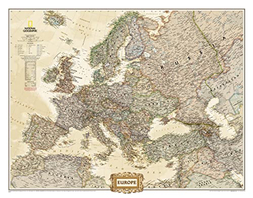
The Executive political map of Europe is a striking example of the cartographic excellence National Geographic is known for. The antique color palette, shaded relief, and easy-to-read fonts make this map both beautiful and functional. International boundaries are clearly defined and thousands of place names, waterbodies, airports, major highways and roads, national parks and more are included.
This map includes complete coverage of the countries and major cities of Albania, Armenia, Austria, Azerbaijan, Belarus, Belgium, Bosnia & Herzegovina, Bulgaria, Croatia, Cyprus, Czech Republic, Denmark, Estonia, Finland, France, Georgia, Germany, Greece, Hungary, Iceland, Ireland, Italy, Kosovo, Latvia, Liechtenstein, Lithuania, Luxembourg, Macedonia, Moldova, Montenegro, The Netherlands, Norway, Poland, Portugal, Romania, Russia, Serbia, Slovakia, Slovenia, Spain, Sweden, Switzerland, Turkey, Ukraine, and the United Kingdom.
The map is encapsulated in heavy-duty 1.6 mil laminate which makes the paper much more durable and resistant to the swelling and shrinking caused by changes in humidity. Laminated maps can be framed without the need for glass, so the fames can be much lighter and less expensive.
- Map Scale = 1:8,400,000
- Sheet Size = 30.5" x 23.75"
The National Geographic Europe Executive Wall Map is perfect for anyone who wants to gain a better understanding of the vastly varied continent of Europe. The continent is laid out in an antique-style colour palette for a more upscale feel, with rich detail with hundreds of place names and borders drawn with utmost accuracy. Scale: 1:8,425,000. Laminated. 76.2 x 61 cm.
��ber diesen Titel� kann sich auf eine andere Ausgabe dieses Titels beziehen.
- VerlagNational Geographic Maps
- Erscheinungsdatum2012
- ISBN 10 0792289846
- ISBN 13 9780792289845
- EinbandMapa
- Anzahl der Seiten1
Beste Suchergebnisse beim ZVAB

Beispielbild f�r diese ISBN
Europe Executive, Laminated: Wall Maps Continents (National Geographic Reference Map)
Verlag:
Natl Geographic Society Maps
(2019)
ISBN 10: 0792289846
ISBN 13: 9780792289845
Gebraucht
Paperback
Anzahl: 1
Anbieter:
Bewertung
Buchbeschreibung Paperback. Zustand: Very Good. The book has been read, but is in excellent condition. Pages are intact and not marred by notes or highlighting. The spine remains undamaged. Artikel-Nr. GOR013676442
Weitere Informationen zu diesem Verk�ufer | Verk�ufer kontaktieren
Gebraucht kaufen
EUR 4,70
W�hrung umrechnen