Verwandte Artikel zu John Muir Trail Topographic Map Guide: National Geographic...
John Muir Trail Topographic Map Guide: National Geographic California: 1001 (National Geographic Trails Illustrated Map)
Zu dieser ISBN ist aktuell kein Angebot verf�gbar.
Alle Exemplare der Ausgabe mit dieser ISBN anzeigen:
Rese�a del editor:
Biograf�a del autor:
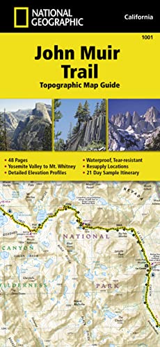
� Waterproof � Tear-Resistant � Topographic Map
National Geographic's Map Guide of the John Muir Trail is an indispensable tool for navigating one of the most famous trails in the United States. Expertly researched and created in partnership with local land management agencies, this product provides detailed topographic maps, interesting history, a waypoint table, information about wilderness safety, and key points of interest you will encounter along the trail. A resupply location chart shows shipping address/contact information, distances, and services available at each resupply point. Each map page has a detailed trail profile that shows the elevation changes you will encounter. Also, the John Muir Trail is highlighted and centered on each page so you can easily track your progress.
The maps start at the northern terminus in Yosemite Valley and progress along the ridge of the Sierra Nevada, past Devils Postpile, and end at the highest point in the lower 48 on the top of Mount Whitney. Along the way you will pass through; Yosemite National Park, Ansel Adams Wilderness, Devils Postpile National Monument, John Muir Wilderness, Kings Canyon National Park, and finally, Sequoia National Park and Mount Whitney. A 21-day sample itinerary is included as well.
Every Topographic Map Guide is printed on "Backcountry Tough" waterproof, tear-resistant paper. A full UTM grid is printed on the map to aid with GPS navigation.
Other features found on this map include: Ansel Adams Wilderness, Bridalveil Fall, El Capitan, Illilouette Falls, Inyo National Forest, John Muir Wilderness, Kings Canyon National Park, Lake Thomas A Edison, Lower Yosemite Fall, Middle Palisade, Mount Agassiz, Mount Darwin, Mount Muir, Mount Pinchot, Mount Powell, Mount Ritter, Mount Russell, Mount Tyndall, Mount Whitney, Mount Williamson, Nevada Fall, North Palisade, Ribbon Fall, Ritter Range, Sequoia National Park, Sierra National Forest, Sierra Nevada, Split Mountain, Upper Yosemite Falls, Vernal Fall, Yosemite National Park, Yosemite Valley.
- Map Scale = 1:63,360
- Folded Size = 4.25" x 9.25"
Founded in 1915 as the Cartographic Group, the first division of National Geographic, National Geographic Maps has been responsible for illustrating the world around us through the art and science of mapmaking.Today, National Geographic Maps continues this mission by creating the world's best wall maps, recreation maps, atlases, and globes which inspire people to care about and explore their world.
��ber diesen Titel� kann sich auf eine andere Ausgabe dieses Titels beziehen.
- VerlagNational Geographic Maps
- Erscheinungsdatum2014
- ISBN 10 1566956897
- ISBN 13 9781566956895
- EinbandMapa
- Anzahl der Seiten1
- Bewertung
Neu kaufen
Mehr zu diesem Angebot erfahren
EUR 17,97
Versand:
EUR 5,24
Von Vereinigtes K�nigreich nach USA
Beste Suchergebnisse beim ZVAB
Beispielbild f�r diese ISBN
John Muir Trail (Topographic Map Guide)
ISBN 10: 1566956897
ISBN 13: 9781566956895
Neu
Anzahl: 5
Anbieter:
Bewertung
Buchbeschreibung sheet map (folded). Zustand: New. Language: ENG. Artikel-Nr. 9781566956895
Weitere Informationen zu diesem Verk�ufer | Verk�ufer kontaktieren
Neu kaufen
EUR 17,97
W�hrung umrechnen
Foto des Verk�ufers
John Muir Trail Map
Verlag:
National Geographic Maps Jan 2022
(2022)
ISBN 10: 1566956897
ISBN 13: 9781566956895
Neu
Anzahl: 20
Anbieter:
Bewertung
Buchbeschreibung Karte. Zustand: Neu. Neuware - National Geographic's Map Guide of the John Muir Trail is an indispensable tool for navigating one of the most famous trails in the United States. The maps start at the northern terminus in Yosemite Valley and progress along the ridge of the Sierra Nevada, past Devils Postpile, and end at the highest point in the lower 48 on the top of Mount Whitney. Along the way you will pass through; Yosemite National Park, Ansel Adams Wilderness, Devils Postpile National Monument, John Muir Wilderness, Kings Canyon National Park, and finally, Sequoia National Park & Mt Whitney. Artikel-Nr. 9781566956895
Weitere Informationen zu diesem Verk�ufer | Verk�ufer kontaktieren
Neu kaufen
EUR 18,91
W�hrung umrechnen
Foto des Verk�ufers
John Muir Trail Topographic Map Guide
Verlag:
National Geographic Maps
(2015)
ISBN 10: 1566956897
ISBN 13: 9781566956895
Neu
Karte/Landkarte
Anzahl: > 20
Anbieter:
Bewertung
Buchbeschreibung Karte/Landkarte. Zustand: New. National Geographic s Map Guide of the John Muir Trail is an indispensable tool for navigating one of the most famous trails in the United States. The maps start at the northern terminus in Yosemite Valley and progress along the ridge of the Sierra Nevada, . Artikel-Nr. 28675431
Weitere Informationen zu diesem Verk�ufer | Verk�ufer kontaktieren
Neu kaufen
EUR 20,82
W�hrung umrechnen