Qatar Geological Map (H.H. the Ruler of Qatar Sheet No. 1) WITH Geological Description of the Qatar Peninsula (Arabian Gulf): Explanation of the 1/100,000 geological maps of Qatar
Cavelier, Claude; Abdulla Salatt; Yves Heuze; Ali Jaidah
Verlag: Department of Petroleum Affairs, Government of Qatar; Bureau de Recherches Geologiques et Minieres, Doha; Paris, 1970
Gebraucht
No Binding
Verk�ufer
Dendera, London, Vereinigtes K�nigreich
Verk�uferbewertung 5 von 5 Sternen
![]()
AbeBooks-Verk�ufer seit 28. M�rz 2013
Dieses Exemplar ist nicht mehr verf�gbar. Hier sind die �hnlichsten Treffer f�r Qatar Geological Map (H.H. the Ruler of Qatar Sheet No. 1) WITH Geological Description of the Qatar Peninsula (Arabian Gulf): Explanation of the 1/100,000 geological maps of Qatar.
Beschreibung
Beschreibung:
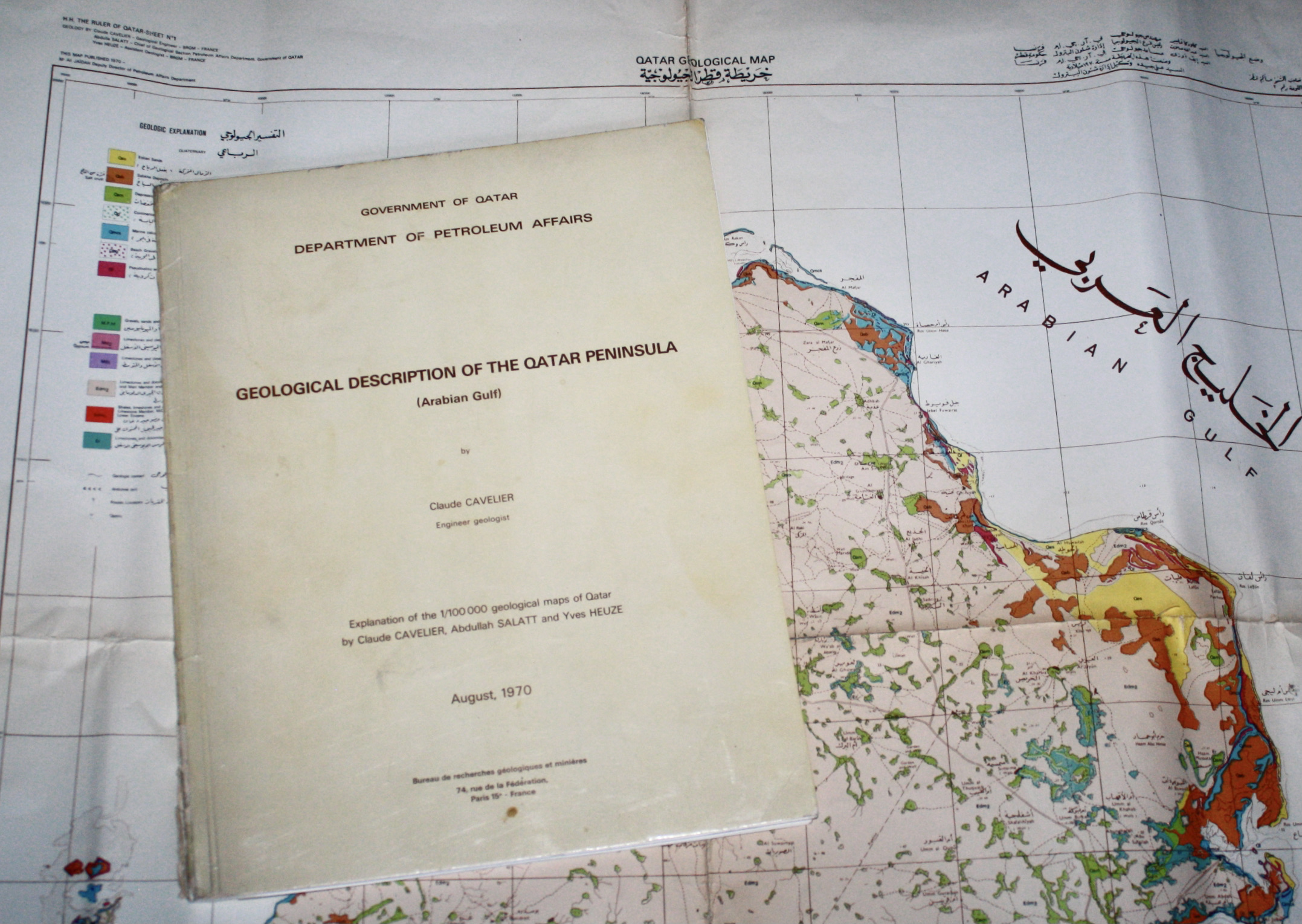
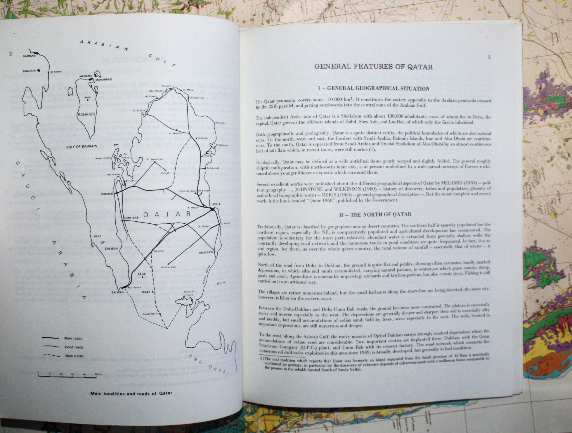
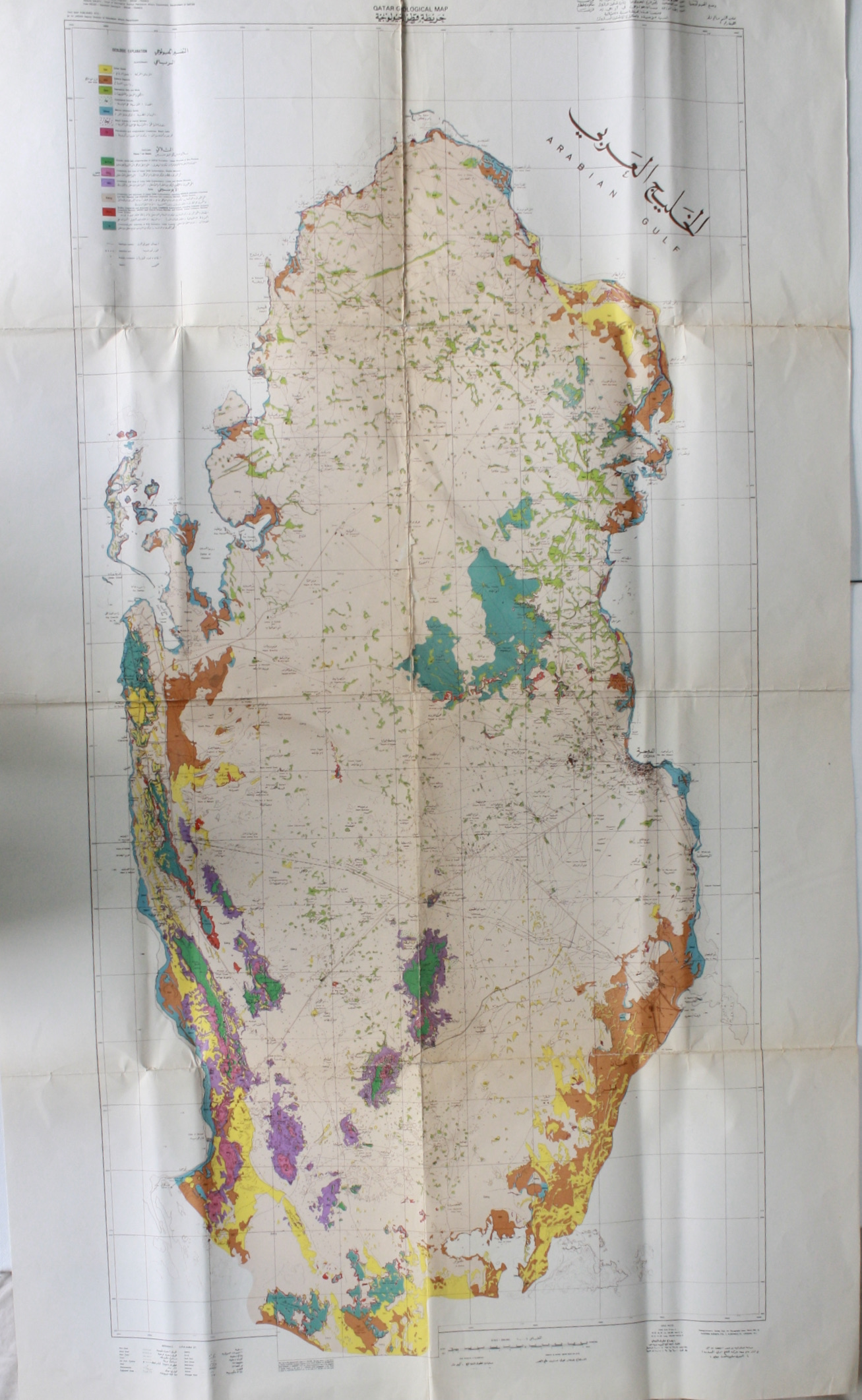
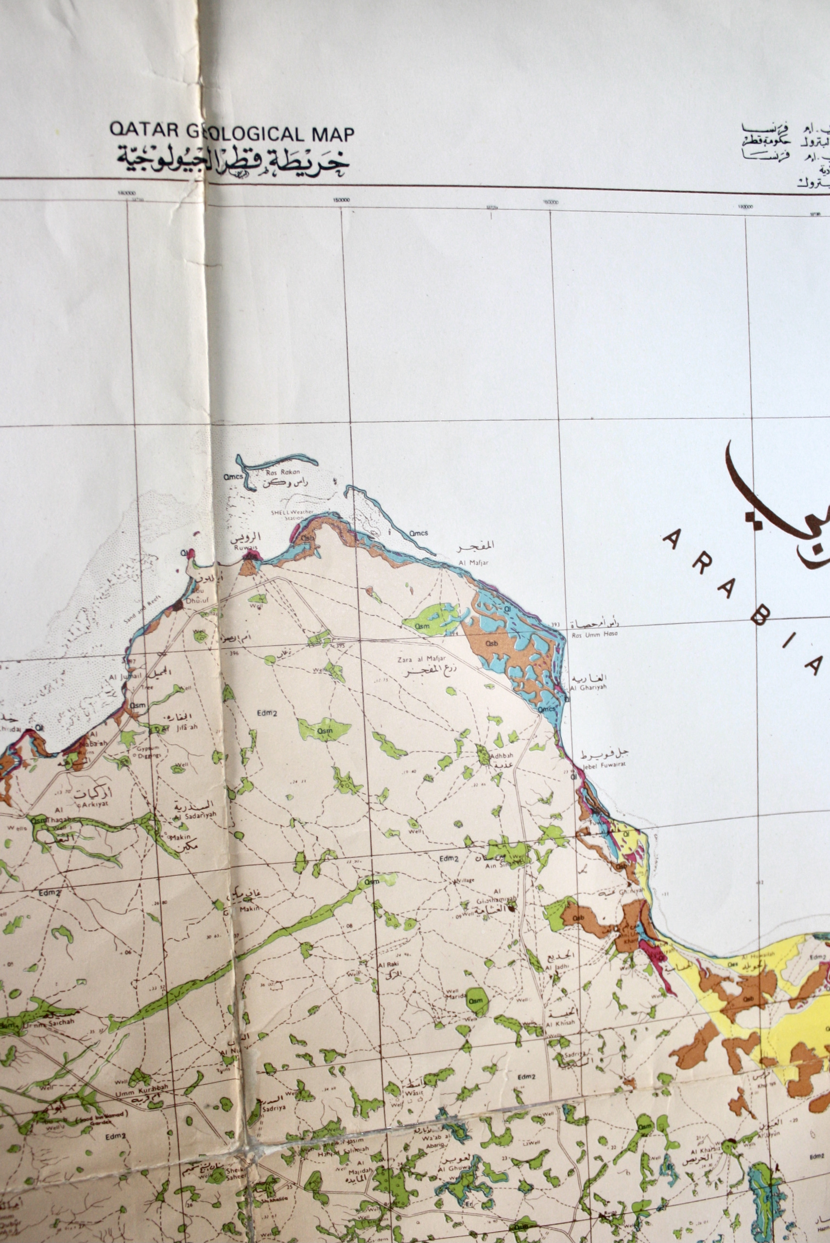
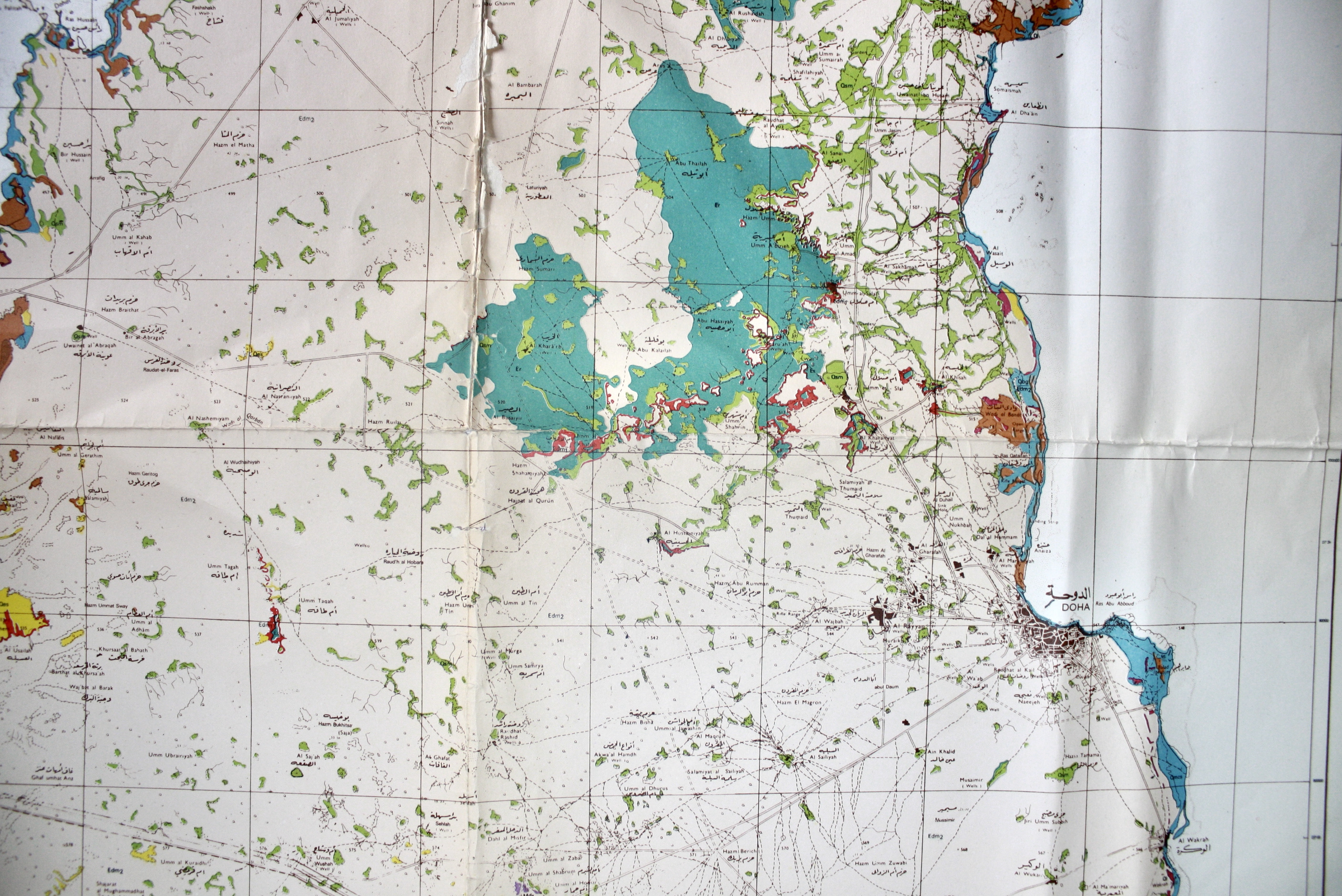
Offered here are two of the major products from the first survey of the entire Qatari Peninsula and islands. The French Bureau de Recherches Geologiques et Minieres (BRGM) conducted the Geological Survey of Surface Formations of Qatar during 1969-70, to advise the Qatari Government about its mineral deposits and their exploitation. Team leader Claude Cavelier here states that its purpose was surpassed (p1), producing the 1/200K map (Sheet No. 1) and report offered here, and a 1/100K map (Sheet No. 2). His team included Qatar's Geological Section Chief Abdulla Salatt a pearl merchant's son and Qatar's first qualified geologist, and BRGM Assistant Geologist Yves Heuze. They reported to the Department of Petroleum Affairs Deputy Director Ali Jaidah. They were supported in the field by Bedouin drivers, Pakistani labourers, and a French Somali chef. Consulting Philby's description, they began by mapping the entire southern border, hampered by a lack of maps, and aerial photos taken in fog by Hunting Surveys. They got lost in the Khor Al Odaid, which was mapped by helicopter. From Doha they explored northeast, visiting Halul by helicopter, and Shraouh and Ishat by boat soon after the boundary agreement with Abu Dhabi. As Hawar was disputed with Bahrain, they used aerial photos instead, with Cavelier later telling Leblanc "The Emir was furious that I did not go". MAP: Cavelier, Salatt and Heuze, colour printed, 66x110cm, captioned in Arabic and English. Good with small loss along folds and archival tape repairs to verso. In addition to geology this shows types of road, oil wells and pipelines, water wells, watercourses, cultivation, sabhka, scrub, sand banks, dunes, depressions, outcrops, graves, and principal points. The Petroleum Affairs Department published 1000 copies of each map, now extremely rare with Worldcat and Library Hub listing only the Sorbonne and Geological Society of London for this (and 13 institutions for Sheet 2). // DESCRIPTION: Cavelier, "Geological Description of the Qatar Peninsula (Arabian Gulf): Explanation of the 1/100,000 geological maps of Qatar", Qatar Dept of Petroleum Affairs; BRGM, Aug 1970. Original printed wraps 21x27cm. (3), 39pp English text including 2 full-page maps + 4 folding diagrams. Covers good, marked, with tears to spine. Sections coming loose, with some underlines in the References list. In addition to geography and geology, this also covers the economy and rural development. Scarce. Ref: Jacques Leblanc "A historical account of the stratigraphy of Qatar, Middle East 1816 to 2015", 2015: pp107-10, 1037, 1064ff for interviews with Cavelier and Salatt, 1122. Bestandsnummer des Verk�ufers 4576
Bibliografische Details
Titel: Qatar Geological Map (H.H. the Ruler of ...
Verlag: Department of Petroleum Affairs, Government of Qatar; Bureau de Recherches Geologiques et Minieres, Doha; Paris
Erscheinungsdatum: 1970
Einband: No Binding
Zustand: Good
Auflage: 1st Edition
Beste Suchergebnisse beim ZVAB

Qatar Geological Map (H.H. the Ruler of Qatar Sheet No. 1). (With): Geological Description of the Qatar Peninsula (Arabian Gulf). Explanation of the 1/100,000 geological maps of Qatar.
Gebraucht
Softcover
Anbieter: Antiquariat INLIBRIS Gilhofer Nfg. GmbH, Vienna, A, �sterreich
Verk�uferbewertung 5 von 5 Sternen
![]()
Folding colour geological map (Sheet No. 1), 660 x 1100 mm, bilingual (Arabic/English). Scale 1:200,000. - 4to pamphlet in original printed wrappers (210 x 270 mm). (3), 39 pages, with 2 full-page maps and 4 folding diagrams. Still the most extensive geological survey of the country: two principal outputs from the BRGM Geological Survey of Surface Formations of Qatar (1969-70), undertaken for the Department of Petroleum Affairs to assess surface formations and mineral resources. - The large-format map (Sheet No. 1) plots the peninsula and islands in colour, combining geological information with a surprisingly detailed record of infrastructure and landscape, including roads and tracks, oil and water wells, pipelines, watercourses, cultivation, sabkha, dunes, depressions, outcrops, graves, and principal points. Cavelier's accompanying Geological Description serves as the explanatory text to the 1:100,000 sheets, and extends beyond stratigraphic description to notes on topography, hydrology, and aspects of the contemporary economy and rural development, with folding diagrams for field use. - Prepared on the eve of Qatar's independence, the survey's mapping programme furnished an early, practical geological baseline for a rapidly expanding petro-state, and for later national mapping initiatives. Reportedly issued in only 1000 copies per sheet, the early Qatar geological sheets are now seldom encountered complete, and the present pairing preserves map and explanation together. - Map with small loss along folds and archival tape repairs to verso. Pamphlet wrappers marked, with tears at spine; gatherings partly loose; occasional underlining to the reference list. - Cf. Jacques LeBlanc, A Historical Account of the Stratigraphy of Qatar, Middle East (1816 to 2015) (2015), pp. 107-110, 1037, 1064ff. Artikel-Nr. 68642
Gebraucht kaufen
EUR 8.500,00
EUR 30,00 Versand
Versand von �sterreich nach USA
Versand von �sterreich nach USA
Anzahl: 1 verf�gbar