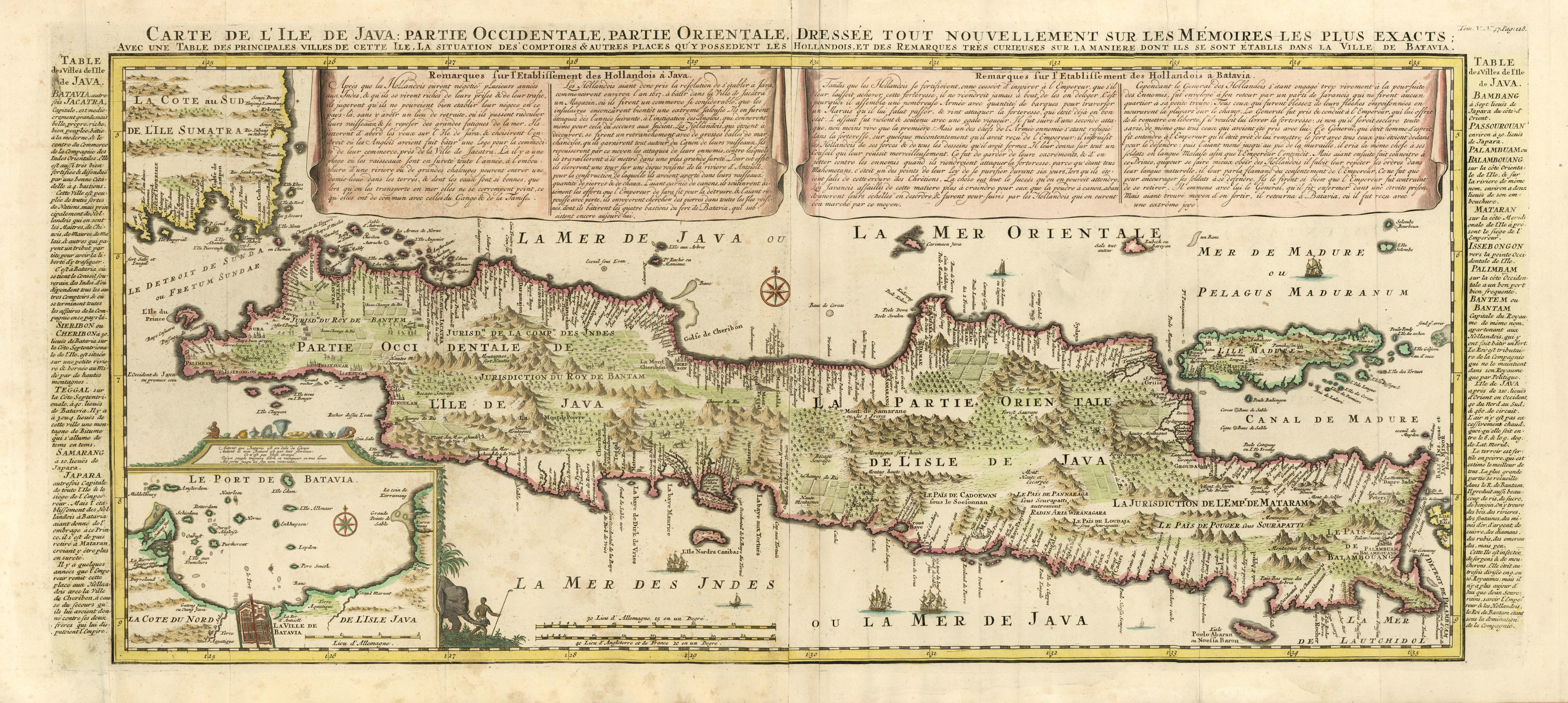
'Carte De L'Ile De Java .':.
JAVA / Indonesien (Indonesia):
Gebraucht
Verk�ufer
Antiquariat Norbert Haas, Bedburg-Hau, Deutschland
Verk�uferbewertung 5 von 5 Sternen
![]()
AbeBooks-Verk�ufer seit 22. Mai 2015
Dieses Exemplar ist nicht mehr verf�gbar. Hier sind die �hnlichsten Treffer f�r 'Carte De L'Ile De Java .':..
Beschreibung
Beschreibung:
Kolorierter Kupferstich von 2 Platten gedruckt v. Nicolas Gueudeville aus Atlas Historique b. L' Honor� & Ch�telain Libraires in Amsterdam, 1719, 38 x 89 Koeman, Atlantes Neerlandici, Vol. II, S. 37, Cha 6, Nr. 9; Tooley's Dic. of Mapm. Rev. Ed. E - J, S. 229 (Nicolas Gueudeville , c. 1654 - c. 1721. French Geographer. Provided the information and wrote the text for Abraham Ch�telain's 'Atlas historique' , Amsterdam 1705-1720; .). - Zeigt die indonesische Insel Java; unten links Insetkarte (ca. 12,5 x 18 cm) der Umgebung von Djarkata (Jakarta / Batavia) mit dem Titel 'Le Port de Batavia.'. - �ber der Karte franz�sische Titelkopfleiste in 2 Zeilen. - Detaillierte u. dekorative Karte der Insel in tadellosem Zustand. Bestandsnummer des Verk�ufers 314944
Bibliografische Details
Titel: 'Carte De L'Ile De Java .':.
Beste Suchergebnisse beim ZVAB

Carte mineralogique de l ile de Java.
Gebraucht
Anbieter: Antiquariat Cellensia, Celle, Deutschland
Verk�uferbewertung 4 von 5 Sternen
![]()
Zustand: -. Stahlstich, koloriert. 23 x 53 cm. In Passepartout. Papier gebr�unt. Artikel-Nr. -32392-
Anzahl: 1 verf�gbar

Foto des Verk�ufers
Un s�jour dans l'Ile de Java. Le pays - Les habitants, le syst�me colonial. Ouvrage enrichi d'une carte et de 20 gravures d'apr�s des photographies.
Verlag:
Librairie Plon, Paris,, 1898
Gebraucht
Anbieter: Bouquinerie du Varis, Russy, FR, Schweiz
Verk�uferbewertung 5 von 5 Sternen
![]()
180x115mm, 294pages, bine complet de la carte d�pliante en fin de l'ouvrage, reliure demi-percaline. Pi�ce de titre et d'auteur dor�s au dos. Plats papier marbr�. Bel exemplaire. En cas de probl�me de commande, veuillez nous contacter via notre page d'accueil / If there is a problem with the order, please contact us via our homepage. Artikel-Nr. 96506
Anzahl: 1 verf�gbar
Foto des Verk�ufers
L'ILLUSTRATION JOURNAL UNIVERSEL N� 2117 - Gravures : Ivan Tourgueneff - Henri Conscience - Paul Siraudin - M. Geoffroy - les grandes manoeuvres belges - Espagne : inauguration du chemin de fer des Asturies, Galice et L�on - carte de l'ile de Java - .
Verlag:
Au bureau du journal 22 septembre 1883, 1883
Gebraucht
Couverture souple
Anbieter: Le-Livre, SABLONS, Frankreich
Verk�uferbewertung 5 von 5 Sternen
![]()
Couverture souple. Zustand: bon. RO10080117: 22 septembre 1883. In-Folio. Broch�. Bon �tat, Couv. convenable, Dos satisfaisant, Int�rieur frais. 16 pages environ illustr�es de nombreuses gravures en noir et blanc - Pagin�es de 178 � 192. . . . Classification Dewey : 70.4417-L'illustration / Figaro salon. Artikel-Nr. RO10080117
Anzahl: 1 verf�gbar
Foto des Verk�ufers
Carte de l'Ile de Java: partie Occidentale, partie Orientale, Dress�e tout nouvellement sur les M�moirs les plus exacts; Avec une Table des principales villes de cette Ile, La situation des comptoirs & autres places qu'y possedent les Hollandois, et des Remarques tr�s curiueuses sur la maniere dont ils se sont �tablis dans la Ville de Batavia.
Verlag:
Henri Abraham Chatelain, Amsterdam, 1720
Gebraucht
Anbieter: Antiquariat Reinhold Berg eK Inh. R.Berg, Regensburg, Deutschland
Verk�uferbewertung 5 von 5 Sternen
![]()
Other. A beautiful example of Henri Chatelain's important 1720 map of Java. The map was produced for Chatelain's 7 volume world atlas out of Amsterdam. Covers the island in full as well as adjacent parts of Sumatra and Bali. The volcanic island of Krakatau, here identified as Cracatao, which nearly 150 years later would erupt with devastating consequences, appears in the Strait of Sunda between Java and Sumatra. In the lower left side is an inset details the city and port of Batavia. Henri Abraham Chatelain (1684 - 1743) was a Huguenot pastor of Parisian origins. He lived consecutively in Paris, St. Martins, London (c. 1710), The Hague (c. 1721) and Amsterdam (c. 1728). He is best known as a Dutch cartographer and more specifically for his cartographic contribution in the seminal seven volume Atlas Historique, published in Amsterdam between 1705 and 1720. Innovative for its time, the Atlas Historique combined fine engraving and artwork with scholarly studies of geography, history, ethnology, heraldry, and cosmography. Some scholarship suggests that the Atlas Historique was not exclusively compiled by Henri Chatelain, as is commonly believed, but rather was a family enterprise involving Henri, his father Zacharie and his brother, also Zacharie. Koeman, Cornelis, Atlantes Neerlandici. Bibliography of Terrestrial, Maritime and Celestial Atlases and Pilot Books, Published in the Netherlands up to 1880, ch 6 (9). Suarez, T., Early Mapping of Southeast Asia, page 232. In two sheets. In excellent condition. Lightstained outside of the image of the map, see illustration. 380 by 880mm (15 by 34� inches). Artikel-Nr. 32296
Anzahl: 1 verf�gbar
Ile de Java. Carte de la partie principale du th��tre de la Guerre de 1825 � 1830, indiquant les positions successives de nos Colonnes Mobiles, et les redoutes (Bentings) �l�v�es � mesure de nos progr�s. Dress�e au Quartier G�n�ral de Magellang, 31 Janvier 1830, par le Major de Steurs.
Gebraucht
Anbieter: Antiquariaat A. Kok & Zn. B.V., Amsterdam, Niederlande
Verk�uferbewertung 4 von 5 Sternen
![]()
Lithographed map with original outline hand colour, on two joined sheets [size of outline ca. 62 x 128 cm]. Published by: Bayly et Huart, Leiden, 1830. - One corner skillfully restored, with fold and overlap as issued, original margins still present (but ocassionally frayed); sharp impression. * Rare map published for F.V.A. de Stuers, M�moires sur la guerre de l'�le de Java, de 1825 � 1830. - Leyde : Luchtmans, 1833. Important printed map of the theatre of the Java War (1825-30), an epic conflict that altered the course of Indonesian history. The war came about when Prince Diponegoro of the powerful autonomous Sultanate of Yogyakarta, and his regional allies, rebelled against Dutch rule over Java. The rebels were motivated by a series of long-simmering grievances against their colonial overlords, to which was added Diponogoro's personal issues with respect to his claim to the disputed throne of his sultanate. The war was a complex affair, as not only was it an anticolonial uprising, but a civil war between Diponegoro and other factions (allied to the Dutch) within Yogyakarta and throughout neighbouring jurisdictions of South-Central Java. Artikel-Nr. 287174
Anzahl: 1 verf�gbar
Foto des Verk�ufers
Carte de l Ile de Java: Partie occidentale, partie oreintale, dresse tout nouvellement sur les memoires les plus exactes
Anbieter: Antique Sommer& Sapunaru KG, M�nchen, Deutschland
Verk�uferbewertung 3 von 5 Sternen
![]()
Technic: Copper print, colorit: coloredcondition: Very good, size (in cm): 38 x 87 cm; - Map shows the Island Java with insert map of the harbour of Batavia. Artikel-Nr. ASS313
Anzahl: 1 verf�gbar
Carte de l'Ile de Java: Partie Occidentale, Partie Orientale, dressee tout nouvellement sure les Memoires les plus exacts: avec une table des principles villes de cette Ile. La situation des comptoirs & autres places qu'y possedent les Hollandois, et remarques tres curieuses sur la maniere don't ils se sont etablis dans la Ville de Batavia.
Gebraucht
Anbieter: Daniel Crouch Rare Books Ltd, London, Vereinigtes K�nigreich
Verk�uferbewertung 4 von 5 Sternen
![]()
One of the earliest printed detailed charts of Java Large folding engraved map on two sheets joined. The important VOC controlled island of Java, with extensive explanatory text in panels on either side and in banners along the top edge, an inset of Le Port de Batavia appears lower left. The Chatelains based their maps on the work of contemporary and earlier cartographers and travel writers, and the current map is based on Hadriaan Reland's map, which was not published by the Dutch until Johannes van Keulen, issued it as 'Insulae Iavae pars Occidentalis edente Hadriano Relando' in 1728. VOC knowledge of the southern coastline of Java was only extended much later in 1739, when Paulus Paulusz, master-kaartenmaker in Batavia at the time, led an expedition there. Artikel-Nr. 17553
Anzahl: 1 verf�gbar
Carte de L �Ile de Java. Chatelain, anno 1719, very good condition and authentic map Carte de l'Ile de Java: Partie Occidentale, Partie Orientale, Dressee tout Nouvellement Sur Les Memoires Les Plus Exacts; By: Henri Abraham Chatelain Date: 1719 (published) Amsterdam Dimensions: 47x92 cm. (sheet). This is an authentic antique map of the island of Java showing portion of Sumatra and Bali. The map was produced for Chatelain's VII volume world atlas out of Amsterdam in 1719 This is without question, the most elaborate, and accurate large format map of the Island of Java and its coastline of the early 18th century. The city and port of Batavia (Jakarta) can be found in the northwest portion of the island as well as in a large insert in the
Gebraucht
Erstausgabe
Anbieter: Hammelburger Antiquariat, Hammelburg, Deutschland
Verk�uferbewertung 5 von 5 Sternen
![]()
Kein Einband. Zustand: Sehr gut. 1. Auflage. Carte de L �Ile de Java. Chatelain, anno 1719, very good condition and authentic map Carte de l'Ile de Java: Partie Occidentale, Partie Orientale, Dressee tout Nouvellement Sur Les Memoires Les Plus Exacts; By: Henri Abraham Chatelain Date: 1719 (published) Amsterdam Dimensions: 47x92 cm. (sheet). This is an authentic antique map of the island of Java showing portion of Sumatra and Bali. The map was produced for Chatelain's VII volume world atlas out of Amsterdam in 1719 This is without question, the most elaborate, and accurate large format map of the Island of Java and its coastline of the early 18th century. The city and port of Batavia (Jakarta) can be found in the northwest portion of the island as well as in a large insert in the lower left portion of the map. Above the map are two drapery style title banners written by Gueudeville, that present the history of the island as well as the presence of the Dutch. Additional text on either side of the map refer to various cities and villages of Java Condition: Map is in very good condition, with wide margins and a strong impression. Artikel-Nr. ABE-1557118939113
Anzahl: 1 verf�gbar