Beschreibung
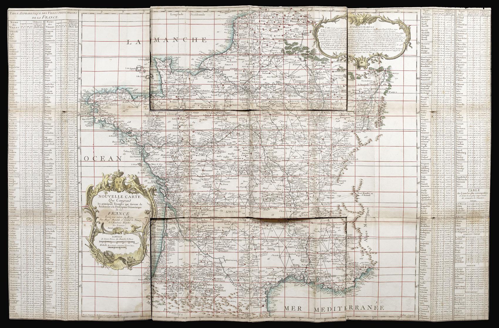
You have cost me more territory than all my enemies! 8vo (195 by 112mm). 184 mapsheets (each approximately 565 by 885mm), dissected and mounted on linen, 50mm tear to 3 maps, small (10 by 5mm) hole in sheet 99, 14 maps with some glue residue, 7 with very slight discolouration, one of the two key maps torn at folds, edged in blue silk, housed within 183 contemporary mottled sheepskin cases, gilt. Collation: 182 mapsheets which, if joined, would comprise an approximately 11 metre square map of France together with two key maps; 'Carte générale de la France par Départemens Servant ŕ l'Assemblage des 182 feuilles.' and 'la Nouvelle carte qui comprend les principaux Triangles qui servent de Fondement ŕ la Description géométrique de La France' (1744). 3 of the smaller maps have been trimmed and mounted to the neighbouring sheets. Namely: sheet 125 (Cherbourg) is attached to sheet 93 (La Houghue), sheet 160 (Noirmoutiers) is attached to sheet 131 (Nantes), and sheet 182 (Camarat) is on sheet 155 (Toulon). A complete set of Cassini's landmark map of France. The first scientific survey of France, the first road "atlas" of France, and the map that, in 1682, some 133 years before its completion, caused Louis XIV to lament that it "cost me more territory than all my enemies!". The great project began in the early 1660s, and would consume four generations of the Cassini family - Jean-Dominique Cassini, or Cassini I (1625-1712); Jacques Cassini, or Cassini II (1677-1756); César-François Cassini, or Cassini III (1714-1784); and Jean- Dominique Cassini or Cassini IV (1748-1845) - for the next 150 years. The map was the brainchild of Jean-Baptiste Colbert, who was minister of finance from 1665 to 1683 in Louis XIV's reign. He envisaged a detailed map of the whole of the royal estate to improve its management and potential revenue. He turned to the newly formed Académie de Sciences for help, and principally to the services of Jean-Dominique Cassini and the surveyor and astronomer Abbé Jean Picard. The survey was carried out using astronomical observations (courtesy of Cassini) to ascertain the precise longitude and hence the accurate measurement of a baseline. Once an accurate baseline had been measured, the surveyors began the trigonometrical survey. These intricate interlocking triangles would become the survey's skeleton, which in turn would be fleshed out by the use of more traditional techniques. Picard outlined his method in his work 'Mesure de la terre' of 1671. The project was "the first general map of an entire nation based on geodetic and topographical measurements . [and] transformed the practice of mapmaking over the next 150 years into a verifiable science" (Brotton). The first map in the survey, the 'Carte particuličre des environs de Paris', was completed by Picard in the late 1660s, and published in 1678 on a scale of 1:86,400 (the standard scale for the whole survey). Picard then turned his attention to surveying the French coast. One of the most startling results of the coastal survey, published in 1684, was that it reduced the overall size of France from 150,000 square kilometres to 120,000 square kilometres. It was this dramatic change that caused the outburst from Louis XIV quoted at the head of this description. Following the publication of the coastal survey, everything was in place for the mapping of the nation to begin. However, Louis' numerous military campaigns had begun to starve the project of funds and, with the death of Cassini in 1712, the project lost its figurehead. Louis himself died three years later. The new king, his great-grandson Louis XV, was only five when he took the throne and the project was put on hold. It would not be until 1733 that Philibert Orrey, Louis XV's controller general, would order Jacques Cassini (Cassini II), to resume the triangulation of the entire nation. Jacques was joined in his endeavour by his son Cassini de Thury (Cassini III), and, by 1744, the triangulation of the country was. Bestandsnummer des Verkäufers 14723
Verkäufer kontaktieren
Diesen Artikel melden

