Zum Hauptinhalt
zvab.com
Suchen
Login
Nutzerkonto
Warenkorb
Hilfe
Menü
Suchen
Nutzerkonto
Meine Bestellungen
Detailsuche
Sammlungen
Bücher sammeln
Kunst & Sammlerstücke
Antiquariate finden
Verkäufer werden
Hilfe
SCHLIESSEN
Maps & Atlases
Sammlung erstellt von
Bow Windows Bookshop (ABA, ILAB)
Beliebteste Artikel
Neu gelistete Artikel
Preis aufsteigend
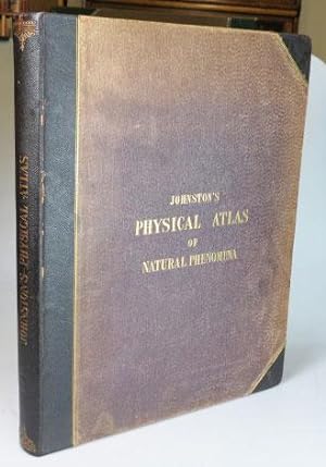
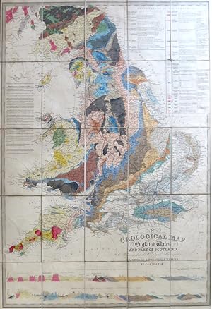
The Physical Atlas of Natural Phenomena
JOHNSTON, Alexander Keith
1850
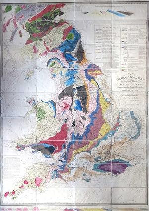
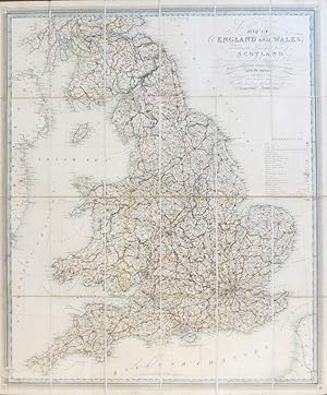
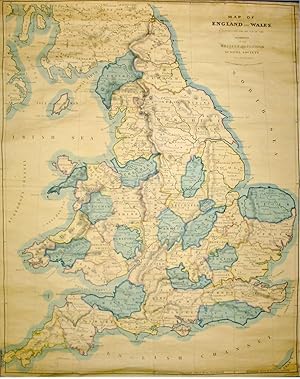
A Geological Map of England & Wales, and Part of Scotland, Showing also the Inland Navigation by ...
WALKER, J. & C. [& KNIPE, J.A.]
1837
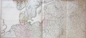
Johnstons' Atlas of the War 1855. [Comprising]: Johnston's New Map of the Seat of War in the Danu...
JOHNSTON, W. & A.K.
1855
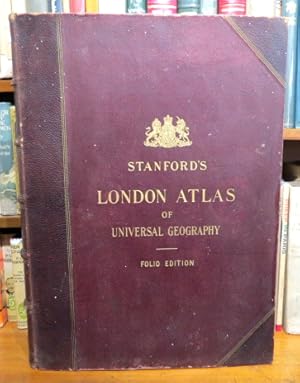
Stanford's London Atlas of Universal Geography. Exhibiting the Physical and Political Divisions o...
STANFORD
1904
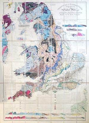
Geological & Mineralogical Map of England & Wales, With Parts of Scotland, Ireland & France, Show...
KNIPE, J.A.
1854
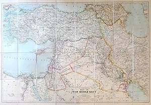
Stanford's Map of the Middle East
STANFORD'S
1933
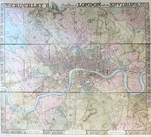
Cruchley's New Plan of London and its Environs
CRUCHLEY, [George Frederick]
1830
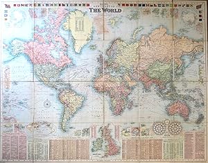
Bacon's New Chart of the World. Mercator's Projection
BACON, G.W.
1906
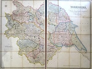
This Map of Yorkshire is Most Respectfully Dedicated to the Nobility, Clergy, Gentry, Landowners ...
HOBSON, William Colling
1843
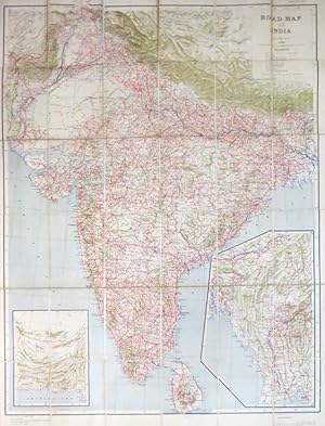
Road Map of India
SURVEY OF INDIA
1943
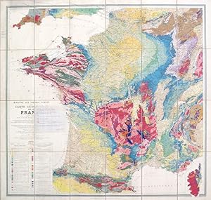
Carte Géologique de la France.
MICHEL-LÉVY, M. Albert
1905
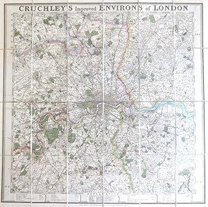
Cruchley's Improved Environs of London
CRUCHLEY, G.F.
1830
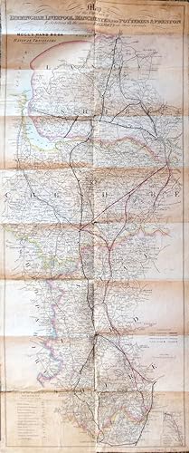
Map of the Environs of Birmingham, Liverpool, Manchester, the Potteries & Preston Exhibiting All ...
MOGG, E.
1839
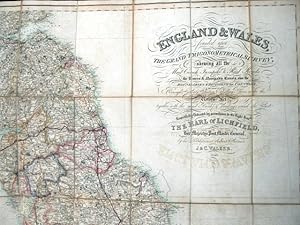
England and Wales founded upon The Grand Trigonometrical Survey; shewing all the Mail Coach, Turn...
WALKER, J. and C.
1840
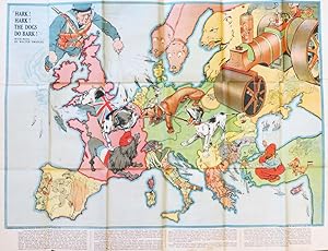
Hark! Hark! The Dogs do Bark! With Note by Walter Emanuel
JOHNSON, RIDDLE & CO, LTD.
1914
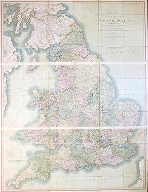
Cary's Six Sheet Map of England and Wales, with Part of Scotland: on which are Carefully Laid Dow...
CARY, J.
1826
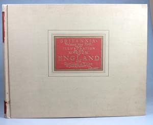
Britannia, Volume the First: or, an Illustration of the Kingdom of England and Dominion of Wales....
OGILBY, John
1939
New Dissected Map of England [and Wales]
(JIGSAW)
1840
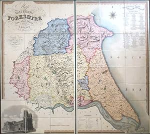
Map of the East Riding of Yorkshire from Actual Survey by. In the Years 1827 & 1828
BRYANT, A.
1829
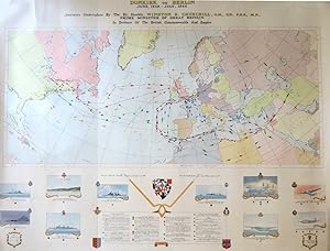
Dunkirk to Berlin June,1940 - July, 1946. Journeys Undertaken by the Rt. Honble. Winston S. Churc...
(CHURCHILL, Winston S.)
1947
A Geological Map of England, Wales, and Part of Scotland, Showing also the Inland Navigation with...
WALKER, J. & C. [& KNIPE, J.A.]
1838
Cruchley's Railway and Excursion Map 24 Miles Round London
CRUCHLEY, G.F.
1857
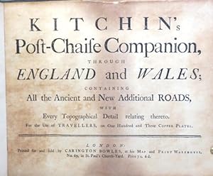
Kitchin's Post-Chaise Companion, through England and Wales; Containing All the Ancient and New Ad...
KITCHIN, Thomas
1770
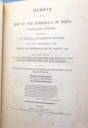
Memoir of the Map of the Peninsula of India; From the Latest Authorities; Exhibiting its Natural,...
RENNELL, Major [James]
1793
[Jigsaw Maps] The World on Mercator's Projection. Scotland. Europe
PHILIP, George & Son, Ltd
1920
London and its Environs (Reduced from the Skeleton Plans)
(ORDNANCE SURVEY) [under the direction of] YOLLAND, Captain
1851
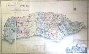
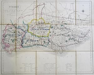
Map of the County of Sussex from an Actual Survey Made in the Years 1823 & 1824 Corrected to the ...
[GREENWOOD, C. & J.] FIGG, William
1861
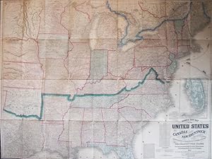
Lloyd's New Map of the United States, the Canadas and New Brunswick. From the Latest Surveys Show...
LLOYD, J.T.
1863
Theatre of War. A Map of the Country Surrounding the Baltic Sea, Comprehending the Northern Part ...
SMITH, C.
1812
The Making of the Nuremberg Chronicle. [By.] Assisted by Joyce Lancaster Wilson. Introduction by ...
WILSON, Adrian
1978
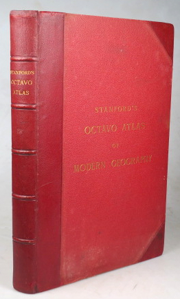
Stanford's Octavo Atlas of Modern Geography
(ATLAS)
1896
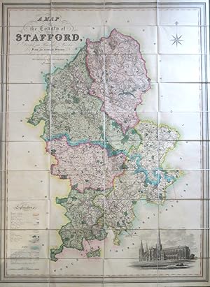
A Map of the County of Stafford Divided into Hundreds & Parishes, From an Accurate Survey, Made i...
PHILLIPS, J. and HUTCHINGS, W.F.
1832
(Fox Hunting Map of) Sussex
WALKER, J. & C.
1851
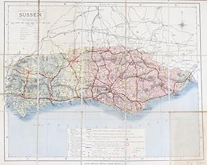
Sussex
LETTS, Son & Co
1884
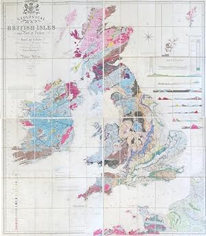
Geological Map of the British Isles and Part of France. Showing also the Inland Navigation by Mea...
KNIPE, I.A. [James Alexander]
1854
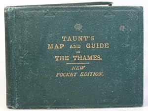
Taunt's Map of the River Thames from Oxford to London, (Pocket Edition). The Maps are Reduced fro...
TAUNT, Henry W.
1882
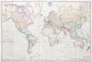
Laurie's Chart of the World on Mercator's Projection. (Reduced from the Large Chart by John Purdy)
LAURIE, Richard Holmes
1857
Calais
CARTE GÉOLOGIQUE DETAILÉE DE LA FRANCE
1878
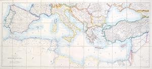
Stanford's Map of the Mediterranean Sea
STANFORD, Edward, Ltd
1923
New and Improved Map of England and Wales, Including the Principal Part of Scotland whereon are C...
GARDNER, W.R.
1825
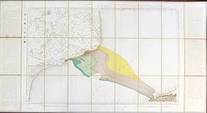
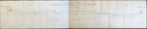
Plan of an Intended Railway from the Town of Lancaster to the Town of Preston in the County Palat...
LOCKE, (Joseph)
1836
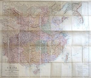
Map of China Prepared for the Inland Mission 1905
BRETSCHNEIDER, E. [in association with] STANFORD, Edward
1905
Map of the Inland Navigation, Canals, and Rail Roads with the Situations of the Various Mineral P...
WALKER, J.
1830
[Mayfair and South Marylebone]
ORDNANCE SURVEY
1872
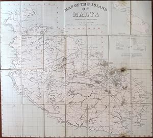
Map of the Island of Malta. Prepared in the Royal Engineers Office, Malta
ROYAL ENGINEERS
1910
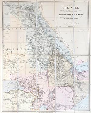
A Map of the Nile, from the equatorial lakes to the Mediterranean, embracing the eastern Sudan (K...
STANFORD, Edward
1898
Mogg's New Plan of London
MOGG, E.
1838
Map of England And Wales, Constructed for the Use of the Schools of the British and Foreign Schoo...
ARROWSMITH, S.
1851
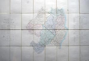
Index to the Townland Survey of the County of Wicklow
ORDNANCE SURVEY
1839
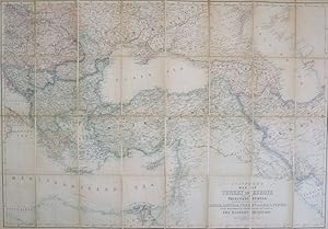
Stanford's Map of Turkey in Europe and Her Tributary States, Together with Such Parts of Russia, ...
STANFORD, Edward
1877
[Collection of Six Folding Maps]: The World on Mercator's Projection. [with] Map Exhibiting the N...
HALL, S. & WALKER, J.
1840
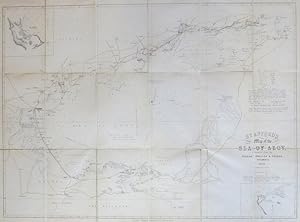
Stanford's Map of the Sea of Azov, Compiled from the Russian, English & French Documents
STANFORD, Edward
1855
Chorographia Britanniae, Or a New Set of Maps of All the Counties in England and Wales:.
(BADESLADE, [Thomas])
1742
[Walworth]. London Sheet XI.15
(ORDNANCE SURVEY)
1895
[Waterloo Bridge & the South Bank]. London Sheet VII.74
(ORDNANCE SURVEY)
1896
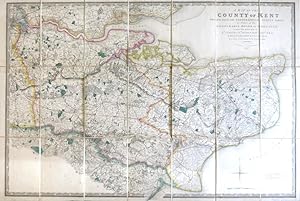
A Map of the County of Kent Drawn from the Topographical Survey Taken, by Order of the Honourable...
(ORDNANCE SURVEY) [under the direction of] MUDGE, Wm., Lt...
1841
Railway Map of Great Britain Compiled from the Plans Deposited According to the Standing Orders o...
WYLD, James
1847
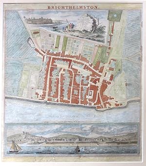
Brighthelmston
YEAKELL, [T]. and GARDNER, [W]
1830
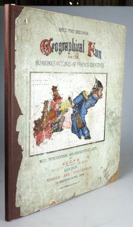
Geographical Fun: Being Humorous Outlines of Various Countries with an Introduction and Descripti...
"ALEPH". [HARVEY, William Henry]
1868
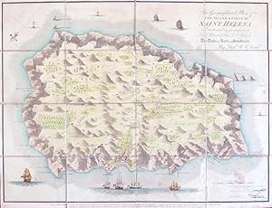
Geographical Plan of the Island and Forts of Saint Helena.
READ, Lieut. R.P.
1815
Weitere Ergebnisse anzeigen
![Johnstons' Atlas of the War 1855. [Comprising]: Johnston's New Map of the Seat of War in the Danu...](http://pictures.abebooks.com/inventory/md/md21841880623.jpg)
![New Dissected Map of England [and Wales]](http://pictures.abebooks.com/inventory/md/md31129871229.jpg)

![[Jigsaw Maps] The World on Mercator's Projection. Scotland. Europe](http://pictures.abebooks.com/inventory/md/md4356464475.jpg)
![The Making of the Nuremberg Chronicle. [By.] Assisted by Joyce Lancaster Wilson. Introduction by ...](http://pictures.abebooks.com/inventory/md/md31805201498.jpg)
![[Mayfair and South Marylebone]](http://pictures.abebooks.com/inventory/md/md30224614287.jpg)

![[Collection of Six Folding Maps]: The World on Mercator's Projection. [with] Map Exhibiting the N...](http://pictures.abebooks.com/inventory/md/md12512023915.jpg)
![[Walworth]. London Sheet XI.15](http://pictures.abebooks.com/inventory/md/md21638506918.jpg)
![[Waterloo Bridge & the South Bank]. London Sheet VII.74](http://pictures.abebooks.com/inventory/md/md21638506919.jpg)