
Gesamtpreis (1 Artikel Artikel):
Versandziel:

national geographic maps jul 2013 (42 Ergebnisse)
Feedback
Direkt zu den wichtigsten Suchergebnissen
Suchfilter
Produktart
- Alle Product Types
- B³cher (42)
- Magazine & Zeitschriften (Keine weiteren Ergebnisse entsprechen dieser Verfeinerung)
- Comics (Keine weiteren Ergebnisse entsprechen dieser Verfeinerung)
- Noten (Keine weiteren Ergebnisse entsprechen dieser Verfeinerung)
- Kunst, Grafik & Poster (Keine weiteren Ergebnisse entsprechen dieser Verfeinerung)
- Fotografien (Keine weiteren Ergebnisse entsprechen dieser Verfeinerung)
- Karten (Keine weiteren Ergebnisse entsprechen dieser Verfeinerung)
- Manuskripte & Papierantiquitõten (Keine weiteren Ergebnisse entsprechen dieser Verfeinerung)
Zustand Mehr dazu
- Neu (42)
- Wie Neu, Sehr Gut oder Gut Bis Sehr Gut (Keine weiteren Ergebnisse entsprechen dieser Verfeinerung)
- Gut oder Befriedigend (Keine weiteren Ergebnisse entsprechen dieser Verfeinerung)
- Ausreichend oder Schlecht (Keine weiteren Ergebnisse entsprechen dieser Verfeinerung)
- Wie beschrieben (Keine weiteren Ergebnisse entsprechen dieser Verfeinerung)
Einband
- alle Einbõnde
- Hardcover (Keine weiteren Ergebnisse entsprechen dieser Verfeinerung)
- Softcover (Keine weiteren Ergebnisse entsprechen dieser Verfeinerung)
Weitere Eigenschaften
- Erstausgabe (Keine weiteren Ergebnisse entsprechen dieser Verfeinerung)
- Signiert (Keine weiteren Ergebnisse entsprechen dieser Verfeinerung)
- Schutzumschlag (Keine weiteren Ergebnisse entsprechen dieser Verfeinerung)
- Angebotsfoto (42)
Sprache (1)
Gratisversand
- Kostenloser Versand nach USA (Keine weiteren Ergebnisse entsprechen dieser Verfeinerung)
Land des Verkõufers
Verkõuferbewertung
-

National Geographic DestinationMap Montreal : City Map & Travel Guide. Points of Interest, Additional Inset Map, Transit System, Travel Information, Top Attraction, 3D Buildings, Airport Terminal Maps, Regional Map, Photos. Waterproof, Durable, Lightweight
Verlag: National Geographic Maps Jul 2013, 2013
ISBN 10: 1597753122 ISBN 13: 9781597753128
Sprache: Englisch
Anbieter: AHA-BUCH GmbH, Einbeck, Deutschland
Verkõuferbewertung 5 von 5 Sternen

EUR 9,00
Wõhrung umrechnenEUR 60,66 f³r den Versand von Deutschland nach USAAnzahl: 2 verf³gbar
In den WarenkorbKarte. Zustand: Neu. Neuware - The newly redesigned National Geographic DestinationMaps series strikes the perfect balance between map and guidebook, and they are the ideal resource for touring culturally and geographically unique areas. All maps are double-sided with beautiful photos and detailed travel information, including comprehensive road networks, local information and natural, historical and cultural places of interest. The maps are printed on durable, waterproof, tear-resistant material that is lightweight and easily folded to fit in your pocket.
-

National Geographic GuideMap U.S. Scenic Drives : What to see and do, top attractions and events, recommmended scenic routes. Road Map & Travel Guide. U.S. Interstate Road Map. Recommeded Scenic Routes, Tourist Information, Photos. Waterproff
Verlag: National Geographic Maps Jul 2013, 2013
ISBN 10: 1597750263 ISBN 13: 9781597750264
Sprache: Englisch
Anbieter: AHA-BUCH GmbH, Einbeck, Deutschland
Verkõuferbewertung 5 von 5 Sternen
EUR 11,64
Wõhrung umrechnenEUR 60,21 f³r den Versand von Deutschland nach USAAnzahl: 2 verf³gbar
In den WarenkorbKarte. Zustand: Neu. Neuware - While GPS is handy for navigating unfamiliar cities, there is nothing better than a printed map for simplicity, perspective and fun on road trips. National Geographic's State Guide Maps are the perfect combination of detailed map and travel guide. Each map contains scenic drives, parks and recreation maps, as well as insets of cities and useful information on local attractions and events. The maps are printed on durable, waterproof, tear-resistant material that is lightweight and easily folded to fit in your pocket.
-

National Geographic GuideMap Maine : City Inset Maps, Points of Interest, National Park Site Listing, Scenic Drive, Top Annual Events, Cities and Towns Index. Road Map & Travel Guide. Waterproof, durable, Lightweight
Verlag: National Geographic Maps Jul 2013, 2013
ISBN 10: 1597753149 ISBN 13: 9781597753142
Sprache: Englisch
Anbieter: AHA-BUCH GmbH, Einbeck, Deutschland
Verkõuferbewertung 5 von 5 Sternen
EUR 11,68
Wõhrung umrechnenEUR 60,21 f³r den Versand von Deutschland nach USAAnzahl: 2 verf³gbar
In den WarenkorbKarte. Zustand: Neu. Neuware - While GPS is handy for navigating unfamiliar cities, there is nothing better than a printed map for simplicity, perspective and fun on road trips. National Geographic's State Guide Maps are the perfect combination of detailed map and travel guide. Each map contains scenic drives, parks and recreation maps, as well as insets of cities and useful information on local attractions and events. The maps are printed on durable, waterproof, tear-resistant material that is lightweight and easily folded to fit in your pocket.
-

National Geographic GuideMap Southern California : What to see and do, top attractions and events, recommmended scenic routes. Road Map & Travel Guide. Waterproof
Verlag: National Geographic Maps Jul 2013, 2013
ISBN 10: 1597750158 ISBN 13: 9781597750158
Sprache: Englisch
Anbieter: AHA-BUCH GmbH, Einbeck, Deutschland
Verkõuferbewertung 5 von 5 Sternen
EUR 11,67
Wõhrung umrechnenEUR 60,23 f³r den Versand von Deutschland nach USAAnzahl: 2 verf³gbar
In den WarenkorbKarte. Zustand: Neu. Neuware - While GPS is handy for navigating unfamiliar cities, there is nothing better than a printed map for simplicity, perspective and fun on road trips. National Geographic's State Guide Maps are the perfect combination of detailed map and travel guide. Each map contains scenic drives, parks and recreation maps, as well as insets of cities and useful information on local attractions and events. The maps are printed on durable, waterproof, tear-resistant material that is lightweight and easily folded to fit in your pocket.
-

National Geographic GuideMap New York : What to see and do, top attractions and events, recommmended scenic routes. Road Map & Travel Guide. Waterproof
Verlag: National Geographic Maps Jul 2013, 2013
ISBN 10: 1597753157 ISBN 13: 9781597753159
Sprache: Englisch
Anbieter: AHA-BUCH GmbH, Einbeck, Deutschland
Verkõuferbewertung 5 von 5 Sternen
EUR 11,67
Wõhrung umrechnenEUR 60,22 f³r den Versand von Deutschland nach USAAnzahl: 1 verf³gbar
In den WarenkorbKarte. Zustand: Neu. Neuware - While GPS is handy for navigating unfamiliar cities, there is nothing better than a printed map for simplicity, perspective and fun on road trips. National Geographic's State Guide Maps are the perfect combination of detailed map and travel guide. Each map contains scenic drives, parks and recreation maps, as well as insets of cities and useful information on local attractions and events. The maps are printed on durable, waterproof, tear-resistant material that is lightweight and easily folded to fit in your pocket.
-

National Geographic DestinationMap Madrid : City Map & Travel Guide. City Map inkl. Nebenkarte 'Madrid Innenstadt', Flughafen-Plan, Sehensw³rdigkeiten. Points of Interest, Additional Inset Map, Transit System, Travel Information, Top Attraction, 3D Buildings, Airport Terminal Maps, Regional Map, Photos. Waterproof, Durable, Lightweight
Verlag: National Geographic Maps Jul 2013, 2013
ISBN 10: 1597754153 ISBN 13: 9781597754156
Sprache: Englisch
Anbieter: AHA-BUCH GmbH, Einbeck, Deutschland
Verkõuferbewertung 5 von 5 Sternen
EUR 11,87
Wõhrung umrechnenEUR 60,22 f³r den Versand von Deutschland nach USAAnzahl: 2 verf³gbar
In den WarenkorbKarte. Zustand: Neu. Neuware - CityDestinationMaps blend urban guidebook information with easy to read street maps, complete with 3D buildings. The maps are printed on waterproof, tear-resistant material that's lightweight yet very durable - idea for travel. This Madrid map is double-sided with beautiful photos and detailed travel information, including local information and natural, historical and cultural places of interest, such as Parque del Retiro, Royal Palace of Madrid, and Queen Sofia Arts Center.
-

National Geographic DestinationMap New Orleans : City Map & Travel Guide. Points of Interest, Additional Inset Map, Transit System, Travel Information, Top Attraction, 3D Buildings, Airport Terminal Maps, Regional Map, Photos. Waterproof, Durable, Lightweight
Verlag: National Geographic Maps Jul 2013, 2013
ISBN 10: 1597754145 ISBN 13: 9781597754149
Sprache: Englisch
Anbieter: AHA-BUCH GmbH, Einbeck, Deutschland
Verkõuferbewertung 5 von 5 Sternen
EUR 11,62
Wõhrung umrechnenEUR 60,22 f³r den Versand von Deutschland nach USAAnzahl: 1 verf³gbar
In den WarenkorbKarte. Zustand: Neu. Neuware - The newly redesigned National Geographic DestinationMaps series strikes the perfect balance between map and guidebook, and they are the ideal resource for touring culturally and geographically unique areas. All maps are double-sided with beautiful photos and detailed travel information, including comprehensive road networks, local information and natural, historical and cultural places of interest. The maps are printed on durable, waterproof, tear-resistant material that is lightweight and easily folded to fit in your pocket.
-

National Geographic Destination Touring Map & Guide The Caribbean : Reise-Karte der ÷stl. Karibik inkl. Fotos, hilfreiche Informationen zu jeder Insel: Domenikanische Republik, Haiti, Puerto Rico, Trinidad und Tobago, Virgin Islands, und the islands of the Lesser Antilles; wichtige Bootsfahrt-Infos, Nebenkarten von Cha.
Verlag: National Geographic Maps Jul 2013, 2013
ISBN 10: 1597754536 ISBN 13: 9781597754538
Sprache: Englisch
Anbieter: AHA-BUCH GmbH, Einbeck, Deutschland
Verkõuferbewertung 5 von 5 Sternen
EUR 14,00
Wõhrung umrechnenEUR 60,47 f³r den Versand von Deutschland nach USAAnzahl: 1 verf³gbar
In den WarenkorbKarte. Zustand: Neu. Neuware - National Geographic's Caribbean Destination Map strikes the perfect balance between map and guidebook and is ideal for a wide range of travelers. The map includes a detailed road network and important travel information including National Parks and protected areas, airports, cruise ports, beaches, historic sites and ruins, and sites for recreation activities including diving, surfing, sailing, and golfing. The Caribbean Destination Map is printed on durable, waterproof and tear-resistant material.
-

National Geographic Adventure Travel Map Tuscany, Italy : Protected Areas, Points of Interest, Detailed Road Network and Town Location Index
Verlag: National Geographic Maps Jul 2013, 2013
ISBN 10: 1566955378 ISBN 13: 9781566955379
Sprache: Englisch
Anbieter: AHA-BUCH GmbH, Einbeck, Deutschland
Verkõuferbewertung 5 von 5 Sternen
EUR 15,30
Wõhrung umrechnenEUR 60,45 f³r den Versand von Deutschland nach USAAnzahl: 1 verf³gbar
In den WarenkorbKarte. Zustand: Neu. Neuware - AdventureMaps provide global travellers with the perfect combination of detail and perspective, highlighting hundreds of points of interest and the diverse and unique destinations within the country. Each map is printed on durable synthetic paper, making them waterproof and tear-resistant. They also include the locations of cities and towns with a user-friendly index, plus a clearly marked road network complete with distances and designations for major highways, main roads and tracks and trails for those seeking to explore more remote regions.
-

National Geographic Adventure Map Turkey : Protected Areas, Points of Interest, Detailed Road Network and Town Location Index
Verlag: National Geographic Maps Jul 2013, 2013
ISBN 10: 1566956110 ISBN 13: 9781566956116
Sprache: Englisch
Anbieter: AHA-BUCH GmbH, Einbeck, Deutschland
Verkõuferbewertung 5 von 5 Sternen
EUR 15,70
Wõhrung umrechnenEUR 60,48 f³r den Versand von Deutschland nach USAAnzahl: 2 verf³gbar
In den WarenkorbKarte. Zustand: Neu. Neuware - AdventureMaps provide global travellers with the perfect combination of detail and perspective, highlighting hundreds of points of interest and the diverse and unique destinations within the country. Each map is printed on durable synthetic paper, making them waterproof and tear-resistant. They also include the locations of cities and towns with a user-friendly index, plus a clearly marked road network complete with distances and designations for major highways, main roads and tracks and trails for those seeking to explore more remote regions.
-
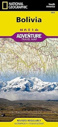
National Geographic Adventure Travel Map Bolivia : Waterproof. Tear-resistent
Verlag: National Geographic Maps Jul 2013, 2013
ISBN 10: 1566956501 ISBN 13: 9781566956505
Sprache: Englisch
Anbieter: AHA-BUCH GmbH, Einbeck, Deutschland
Verkõuferbewertung 5 von 5 Sternen
EUR 15,75
Wõhrung umrechnenEUR 60,49 f³r den Versand von Deutschland nach USAAnzahl: 1 verf³gbar
In den WarenkorbKarte. Zustand: Neu. Neuware - AdventureMaps provide global travellers with the perfect combination of detail and perspective, highlighting hundreds of points of interest and the diverse and unique destinations within the country. Each map is printed on durable synthetic paper, making them waterproof and tear-resistant. They also include the locations of cities and towns with a user-friendly index, plus a clearly marked road network complete with distances and designations for major highways, main roads and tracks and trails for those seeking to explore more remote regions.
-

National Geographic Adventure Travel Map TK Guatemala 500T. : Waterproof. Tear-resistent
Verlag: National Geographic Maps Jul 2013, 2013
ISBN 10: 1566956544 ISBN 13: 9781566956543
Sprache: Englisch
Anbieter: AHA-BUCH GmbH, Einbeck, Deutschland
Verkõuferbewertung 5 von 5 Sternen
EUR 15,29
Wõhrung umrechnenEUR 60,48 f³r den Versand von Deutschland nach USAAnzahl: 2 verf³gbar
In den WarenkorbKarte. Zustand: Neu. Neuware - AdventureMaps provide global travellers with the perfect combination of detail and perspective, highlighting hundreds of points of interest and the diverse and unique destinations within the country. Each map is printed on durable synthetic paper, making them waterproof and tear-resistant. They also include the locations of cities and towns with a user-friendly index, plus a clearly marked road network complete with distances and designations for major highways, main roads and tracks and trails for those seeking to explore more remote regions.
-

National Geographic Adventure Travel Map Cuba : Waterproof. Tear-resistent
Verlag: National Geographic Maps Jul 2013, 2013
ISBN 10: 1566956528 ISBN 13: 9781566956529
Sprache: Englisch
Anbieter: AHA-BUCH GmbH, Einbeck, Deutschland
Verkõuferbewertung 5 von 5 Sternen
EUR 15,50
Wõhrung umrechnenEUR 60,48 f³r den Versand von Deutschland nach USAAnzahl: 1 verf³gbar
In den WarenkorbKarte. Zustand: Neu. Neuware - AdventureMaps provide global travellers with the perfect combination of detail and perspective, highlighting hundreds of points of interest and the diverse and unique destinations within the country. Each map is printed on durable synthetic paper, making them waterproof and tear-resistant. They also include the locations of cities and towns with a user-friendly index, plus a clearly marked road network complete with distances and designations for major highways, main roads and tracks and trails for those seeking to explore more remote regions.
-

National Geographic Trails Illustrated Map Shenandoah National Park, Virginia, USA : Outdoor Recreation Map
Verlag: National Geographic Maps Jul 2013, 2013
ISBN 10: 1566953650 ISBN 13: 9781566953658
Sprache: Englisch
Anbieter: AHA-BUCH GmbH, Einbeck, Deutschland
Verkõuferbewertung 5 von 5 Sternen
EUR 15,75
Wõhrung umrechnenEUR 60,47 f³r den Versand von Deutschland nach USAAnzahl: 2 verf³gbar
In den WarenkorbKarte. Zustand: Neu. Neuware - National Geographic's Trails Illustrated Maps are the most detailed and up-to-date topographic recreation maps available for US National Parks, National Forests and other popular outdoor recreation areas. A necessity for exploring the outdoors, each map is printed on waterproof, tear-resistant material. They also contain key safety and contact information, GPS and compass coordinates, Leave No Trace ethical guidelines and hundreds of points-of-interest, including scenic viewpoints, campgrounds, boat launches, swimming areas, marine sanctuaries and wildlife refuges.
-

National Geographic Trails Illustrated Map Acadia National Park, Maine, USA : Outdoor Recreation Map. Isle Au Haut, Mount Desert Island, and Schoodic Peninsula Inset Maps, Lamoine State Park, Detailed Trail Charts
Verlag: National Geographic Maps Jul 2013, 2013
ISBN 10: 1566953529 ISBN 13: 9781566953528
Sprache: Englisch
Anbieter: AHA-BUCH GmbH, Einbeck, Deutschland
Verkõuferbewertung 5 von 5 Sternen
EUR 15,75
Wõhrung umrechnenEUR 60,48 f³r den Versand von Deutschland nach USAAnzahl: 2 verf³gbar
In den WarenkorbKarte. Zustand: Neu. Neuware - This Trails Illustrated topographic map is the most comprehensive recreational map for Acadia National Park, located along the beautiful Atlantic coast in Maine. Updated to reflect road closings, new trails, and campground relocation; it also includes detailed trail information, points of interest, trailheads, picnic areas, facilities, and more. Features sites such as Mount Desert Island, Sestern Mountain, Norwood Ridge, Freeman Ridge, Isle au Haut, Marshall Island, Swans Island, Western Bay, Mount Desert Narrows, Frenchman Bay, Eastern Way, Echo Lake, and more.
-

National Geographic Trails Illustrated Topographic Map Banff South : Banff and Kootenay National Parks. Alberta, British Columbia. Waterproof. Tear-resistent
Verlag: National Geographic Maps Jul 2013, 2013
ISBN 10: 1566956587 ISBN 13: 9781566956581
Sprache: Englisch
Anbieter: AHA-BUCH GmbH, Einbeck, Deutschland
Verkõuferbewertung 5 von 5 Sternen
EUR 15,70
Wõhrung umrechnenEUR 60,46 f³r den Versand von Deutschland nach USAAnzahl: 2 verf³gbar
In den WarenkorbKarte. Zustand: Neu. Neuware - Trails Illustrated topographic maps are the most detailed and up-to-date recreation maps available for these national parks, national forests and popular outdoor recreation areas. The front side of the Banff South map details the north side of the national park, and also covers survival tips, entry fees and what to do while visiting. The reverse side of the map details the south side of the park, while insets show tips on outdoor ethics, and activities while visiting Kootenay National Park such as backpacking, camping, biking, hiking and the hot springs.
-

National Geographic Adventure Map Mexico : Waterproof. Tear-resistent
Verlag: National Geographic Maps Jul 2013, 2013
ISBN 10: 1566955270 ISBN 13: 9781566955270
Sprache: Englisch
Anbieter: AHA-BUCH GmbH, Einbeck, Deutschland
Verkõuferbewertung 5 von 5 Sternen
EUR 15,70
Wõhrung umrechnenEUR 60,48 f³r den Versand von Deutschland nach USAAnzahl: 2 verf³gbar
In den WarenkorbKarte. Zustand: Neu. Neuware - AdventureMaps provide global travellers with the perfect combination of detail and perspective, highlighting hundreds of points of interest and the diverse and unique destinations within the country. Each map is printed on durable synthetic paper, making them waterproof and tear-resistant. The north side of the map details from the U.S. Border south to Aguascalientes, including Baja California, Chihuahua, Tijuana, Mazatlan, and Monterrey. The south side covers major Mexican cities, such as Acapulco and Cancun, plus Belize and nearly all of Guatemala at the same scale.
-

National Geographic Adventure Travel Map Morocco : Waterproof. Tear-resistent
Verlag: National Geographic Maps Jul 2013, 2013
ISBN 10: 1566955300 ISBN 13: 9781566955300
Sprache: Englisch
Anbieter: AHA-BUCH GmbH, Einbeck, Deutschland
Verkõuferbewertung 5 von 5 Sternen
EUR 15,70
Wõhrung umrechnenEUR 60,47 f³r den Versand von Deutschland nach USAAnzahl: 2 verf³gbar
In den WarenkorbKarte. Zustand: Neu. Neuware - This AdventureMap highlights the diverse, unique, and exotic destinations within Morocco. In addition to typical sites of interest such as World Heritage sites, national parks, mosques, churches, and archaeological sites, this map includes Morocco's many casbahs and marabouts making it invaluable to travellers hoping to experience the country s rich history and culture. Beaches, yachting harbours, and popular fishing and surfing areas along Morocco's extensive Mediterranean and Atlantic coastlines are marked, as are ski resorts, golf courses, spas, and oases.
-

National Geographic Trails Illustrated Topographic Map Banff North : Banff and Yoho National Parks. Alberta / British Columbia. Waterproof. Tear-resistant
Verlag: National Geographic Maps Jul 2013, 2013
ISBN 10: 1566956595 ISBN 13: 9781566956598
Sprache: Englisch
Anbieter: AHA-BUCH GmbH, Einbeck, Deutschland
Verkõuferbewertung 5 von 5 Sternen
EUR 15,69
Wõhrung umrechnenEUR 60,48 f³r den Versand von Deutschland nach USAAnzahl: 1 verf³gbar
In den WarenkorbKarte. Zustand: Neu. Neuware - Trails Illustrated topographic maps are the most detailed and up-to-date recreation maps available for these national parks, national forests and popular outdoor recreation areas. The front side of the Banff North map details the south side of the national park, and also covers survival tips, area trails, entry fees and details both Kootenay and Yoho Nationals Parks. The reverse side of the map details the north side of the park, while insets show safe travel in Bear Country, and all the recreation the park has to offer. The map is printed on waterproof, tear-resistant material.
-

National Geographic Adventure Travel Map Spain, Portugal : Waterproof. Tear-resistent
Verlag: National Geographic Maps Jul 2013, 2013
ISBN 10: 1566955394 ISBN 13: 9781566955393
Sprache: Englisch
Anbieter: AHA-BUCH GmbH, Einbeck, Deutschland
Verkõuferbewertung 5 von 5 Sternen
EUR 15,70
Wõhrung umrechnenEUR 60,46 f³r den Versand von Deutschland nach USAAnzahl: 2 verf³gbar
In den WarenkorbKarte. Zustand: Neu. Neuware - AdventureMaps provide global travellers with the perfect combination of detail and perspective, highlighting hundreds of points of interest and the diverse and unique destinations within the country. Each map is printed on durable synthetic paper, making them waterproof and tear-resistant. They also include the locations of cities and towns with a user-friendly index, plus a clearly marked road network complete with distances and designations for major highways, main roads and tracks and trails for those seeking to explore more remote regions.
-

National Geographic Adventure Map Brazil : Waterproof. Tear-resistent
Verlag: National Geographic Maps Jul 2013, 2013
ISBN 10: 1566955459 ISBN 13: 9781566955454
Sprache: Englisch
Anbieter: AHA-BUCH GmbH, Einbeck, Deutschland
Verkõuferbewertung 5 von 5 Sternen
EUR 15,70
Wõhrung umrechnenEUR 60,48 f³r den Versand von Deutschland nach USAAnzahl: 1 verf³gbar
In den WarenkorbKarte. Zustand: Neu. Neuware - AdventureMaps are the most authoritative maps for touring international destinations. The front side of the Brazil map includes the western half of the country and features the remarkable Amazon Basin and the Mato Grosso Plateau, as well as airports, airfields, anchorages, and other travel aids invaluable for adventurers seeking to explore the tropical rainforests, savannahs, and woodlands at the heart of the country's interior. The eastern half of the country is covered on the reverse, including the capital of Brasilia and the cities of Sao Paulo, Rio de Janeiro, Salvador and more.
-

National Geographic Adventure Travel Map Canada West : Waterproof. Tear-resistent
Verlag: National Geographic Maps Jul 2013, 2013
ISBN 10: 1566956358 ISBN 13: 9781566956352
Sprache: Englisch
Anbieter: AHA-BUCH GmbH, Einbeck, Deutschland
Verkõuferbewertung 5 von 5 Sternen
EUR 15,84
Wõhrung umrechnenEUR 60,46 f³r den Versand von Deutschland nach USAAnzahl: 2 verf³gbar
In den WarenkorbKarte. Zustand: Neu. Neuware - - Waterproof - Tear-Resistant - Travel Map.
-

National Geographic Adventure Travel Map France : Waterproof. Tear-resistent
Verlag: National Geographic Maps Jul 2013, 2013
ISBN 10: 1566956048 ISBN 13: 9781566956048
Sprache: Englisch
Anbieter: AHA-BUCH GmbH, Einbeck, Deutschland
Verkõuferbewertung 5 von 5 Sternen
EUR 15,91
Wõhrung umrechnenEUR 60,48 f³r den Versand von Deutschland nach USAAnzahl: 2 verf³gbar
In den WarenkorbKarte. Zustand: Neu. Neuware - AdventureMaps provide global travellers with the perfect combination of detail and perspective, highlighting hundreds of points of interest and the diverse and unique destinations within the country. Each map is printed on durable synthetic paper, making them waterproof and tear-resistant. They also include the locations of cities and towns with a user-friendly index, plus a clearly marked road network complete with distances and designations for major highways, main roads and tracks and trails for those seeking to explore more remote regions.
-

National Geographic Destination Touring Map & Guide Alaska's Inside Passage : Waterproof. Tear-resistent
Verlag: National Geographic Maps Jul 2013, 2013
ISBN 10: 159775451X ISBN 13: 9781597754514
Sprache: Englisch
Anbieter: AHA-BUCH GmbH, Einbeck, Deutschland
Verkõuferbewertung 5 von 5 Sternen
EUR 15,64
Wõhrung umrechnenEUR 60,48 f³r den Versand von Deutschland nach USAAnzahl: 1 verf³gbar
In den WarenkorbKarte. Zustand: Neu. Neuware - Explore the exhilarating majesty and mystique of Southeast Alaska with National Geographic's Alaska's Inside Passage Destination Map. The Inside Passage is a meandering waterway formed by a myriad of islands that lie between the North Pacific Ocean and the quieter waters along the coast. At its heart is the Tongass National Forest, the largest national forest in the United States which at a staggering 16.8 million acres contains 19 designated wilderness areas and the Admiralty Island and Misty Fiords National Monuments.
-

National Geographic Trails Illustrated Map Great Smoky Mountains National Park, Tennessee / North Carolina, USA : Outdoor Recreation Map. Appalachian Trail, Benton MacKaye Trail, Mountains-to-Sea Trail, Backcountry Campsites, Stream Crossing Charts, Trail Mileages
Verlag: National Geographic Maps Jul 2013, 2013
ISBN 10: 1566953014 ISBN 13: 9781566953016
Sprache: Englisch
Anbieter: AHA-BUCH GmbH, Einbeck, Deutschland
Verkõuferbewertung 5 von 5 Sternen
EUR 15,70
Wõhrung umrechnenEUR 60,48 f³r den Versand von Deutschland nach USAAnzahl: 2 verf³gbar
In den WarenkorbKarte. Zustand: Neu. Neuware - America's most visited national park straddles Tennessee and North Carolina with its seemingly endless forest. The map includes the park in its entirety; the Appalachian Trail; Twentymile Trail; Lakeshore Trail; Chasteen Creek Trail; the Great Smoky Mountains; Chilowee Mountain; Little Mountain; the Blue Ridge Parkway; Cataloochee Divide; Cherokee National Forest; Nantahala National Forest; Little Tennessee River; Chilhowee Lake; Fontana Lake; the cities of Maryville and Gatlinburg Tennessee, and Waynesville, North Carolina; and more. UTM grids for use with GPS.
-

National Geographic Adventure Travel Map Puerto Rico : Sehensw³rdigkeiten mit Naturschutzgebieten und historischen Attraktionen
Verlag: National Geographic Maps Jul 2013, 2013
ISBN 10: 1566955181 ISBN 13: 9781566955188
Sprache: Englisch
Anbieter: AHA-BUCH GmbH, Einbeck, Deutschland
Verkõuferbewertung 5 von 5 Sternen
EUR 15,75
Wõhrung umrechnenEUR 60,48 f³r den Versand von Deutschland nach USAAnzahl: 1 verf³gbar
In den WarenkorbKarte. Zustand: Neu. Neuware - AdventureMaps provide global travellers with the perfect combination of detail and perspective, highlighting hundreds of points of interest and the diverse and unique destinations within the country. Each map is printed on durable synthetic paper, making them waterproof and tear-resistant. They also include the locations of cities and towns with a user-friendly index, plus a clearly marked road network complete with distances and designations for major highways, main roads and tracks and trails for those seeking to explore more remote regions.
-

National Geographic Adventure Travel Map Ireland : Waterproof. Tear-resistent
Verlag: National Geographic Maps Jul 2013, 2013
ISBN 10: 1566955351 ISBN 13: 9781566955355
Sprache: Englisch
Anbieter: AHA-BUCH GmbH, Einbeck, Deutschland
Verkõuferbewertung 5 von 5 Sternen
EUR 15,80
Wõhrung umrechnenEUR 60,47 f³r den Versand von Deutschland nach USAAnzahl: 1 verf³gbar
In den WarenkorbKarte. Zustand: Neu. Neuware - AdventureMaps provide global travellers with the perfect combination of detail and perspective. The north side of the Ireland map details from the northernmost tip of the island at Malin Head south to Dublin and Galway, including Belfast, Londonderry, and Sligo. The south side covers the remainder of the country including the cities of Limerick, Tralee, Cork, and Waterford. An inset map provides detail of the Skellig Islands. Sites of interest from prehistoric monuments and castles to churches and abbeys are noted making this map indispensable for the inquisitive traveller.
-

National Geographic Trails Illustrated Map Joshua Tree National Park : Topographic Map. Waterproof. Tear-resistent
Verlag: National Geographic Maps Jul 2013, 2013
ISBN 10: 1566953006 ISBN 13: 9781566953009
Sprache: Englisch
Anbieter: AHA-BUCH GmbH, Einbeck, Deutschland
Verkõuferbewertung 5 von 5 Sternen
EUR 15,80
Wõhrung umrechnenEUR 60,47 f³r den Versand von Deutschland nach USAAnzahl: 2 verf³gbar
In den WarenkorbKarte. Zustand: Neu. Neuware - National Geographic's Trails Illustrated Maps are the most detailed and up-to-date topographic recreation maps available for US National Parks, National Forests and other popular outdoor recreation areas. A necessity for exploring the outdoors, each map is printed on waterproof, tear-resistant material. They also contain key safety and contact information, GPS and compass coordinates, Leave No Trace ethical guidelines and hundreds of points-of-interest, including scenic viewpoints, campgrounds, boat launches, swimming areas, marine sanctuaries and wildlife refuges.
-

National Geographic Adventure Travel Map Southern France : Protected Areas, Points of Interest, Detailed Road Network and Town Location Index
Verlag: National Geographic Maps Jul 2013, 2013
ISBN 10: 1566956056 ISBN 13: 9781566956055
Sprache: Englisch
Anbieter: AHA-BUCH GmbH, Einbeck, Deutschland
Verkõuferbewertung 5 von 5 Sternen
EUR 15,80
Wõhrung umrechnenEUR 60,47 f³r den Versand von Deutschland nach USAAnzahl: 2 verf³gbar
In den WarenkorbKarte. Zustand: Neu. Neuware - AdventureMaps provide global travellers with the perfect combination of detail and perspective, highlighting hundreds of points of interest and the diverse and unique destinations within the country. Each map is printed on durable synthetic paper, making them waterproof and tear-resistant. They also include the locations of cities and towns with a user-friendly index, plus a clearly marked road network complete with distances and designations for major highways, main roads and tracks and trails for those seeking to explore more remote regions.
-

National Geographic Trails Illustrated Map Zion National Park : Topographic Map. Waterproof. Tear-resistent
Verlag: National Geographic Maps Jul 2013, 2013
ISBN 10: 1566952972 ISBN 13: 9781566952972
Sprache: Englisch
Anbieter: AHA-BUCH GmbH, Einbeck, Deutschland
Verkõuferbewertung 5 von 5 Sternen
EUR 15,65
Wõhrung umrechnenEUR 60,48 f³r den Versand von Deutschland nach USAAnzahl: 1 verf³gbar
In den WarenkorbKarte. Zustand: Neu. Neuware - National Geographic's Trails Illustrated Maps are the most detailed and up-to-date topographic recreation maps available for US National Parks, National Forests and other popular outdoor recreation areas. A necessity for exploring the outdoors, each map is printed on waterproof, tear-resistant material. They also contain key safety and contact information, GPS and compass coordinates, Leave No Trace ethical guidelines and hundreds of points-of-interest, including scenic viewpoints, campgrounds, boat launches, swimming areas, marine sanctuaries and wildlife refuges.