
Gesamtpreis (1 Artikel Artikel):
Versandziel:

county highway (6 Ergebnisse)
Direkt zu den wichtigsten Suchergebnissen
Suchfilter
Produktart
- Alle Product Types
- Bücher (5)
- Magazine & Zeitschriften (Keine weiteren Ergebnisse entsprechen dieser Verfeinerung)
- Comics (Keine weiteren Ergebnisse entsprechen dieser Verfeinerung)
- Noten (Keine weiteren Ergebnisse entsprechen dieser Verfeinerung)
- Kunst, Grafik & Poster (Keine weiteren Ergebnisse entsprechen dieser Verfeinerung)
- Fotografien (Keine weiteren Ergebnisse entsprechen dieser Verfeinerung)
- Karten (1)
- Manuskripte & Papierantiquitäten (Keine weiteren Ergebnisse entsprechen dieser Verfeinerung)
Zustand Mehr dazu
- Neu (3)
- Wie Neu, Sehr Gut oder Gut Bis Sehr Gut (Keine weiteren Ergebnisse entsprechen dieser Verfeinerung)
- Gut oder Befriedigend (1)
- Ausreichend oder Schlecht (1)
- Wie beschrieben (1)
Einband
Weitere Eigenschaften
- Erstausgabe (Keine weiteren Ergebnisse entsprechen dieser Verfeinerung)
- Signiert (Keine weiteren Ergebnisse entsprechen dieser Verfeinerung)
- Schutzumschlag (Keine weiteren Ergebnisse entsprechen dieser Verfeinerung)
- Angebotsfoto (2)
Sprache (2)
Preis
- Beliebiger Preis
- Weniger als EUR 20 (Keine weiteren Ergebnisse entsprechen dieser Verfeinerung)
- EUR 20 bis EUR 45
- Mehr als EUR 45
Gratisversand
Land des Verkäufers
Verkäuferbewertung
-

PAP. Zustand: New. New Book. Shipped from UK. Established seller since 2000.
-
Life Sentences
Anbieter: PBShop.store UK, Fairford, GLOS, Vereinigtes Königreich
Verkäuferbewertung 4 von 5 Sternen

EUR 22,99
EUR 4,80 Versand
Versand von Vereinigtes Königreich nach USAAnzahl: 2 verfügbar
In den WarenkorbPAP. Zustand: New. New Book. Delivered from our UK warehouse in 4 to 14 business days. Established seller since 2000.
-

Map of Milwaukee County Showing System of Federal, State and County Trunk Highways
Verlag: Milwaukee County Highway Dept., Milwaukee, WI, 1930
Anbieter: Voyageur Book Shop, Milwaukee, WI, USA
Verkäuferbewertung 5 von 5 Sternen

Karte
Portfolio. Zustand: Very Good. 12.5" by 19.5" map in black, red, green and blue ink. Size: 12mo - over 6ľ" - 7ľ" Tall. MC.
-
Report of a Study of Highway Traffic and the Highway System of Cook County, Illinois
Verlag: The United States Board of Public Roads; The Cook County Highway Department
Anbieter: Wonder Book, Frederick, MD, USA
Verkäuferbewertung 5 von 5 Sternen
Zustand: Fair. Acceptable condition. Former Library book. (Transportation, Illinois) A readable, intact copy that may have noticeable tears and wear to the spine. All pages of text are present, but they may include extensive notes and highlighting or be heavily stained. Includes reading copy only books. Bundled media such as CDs, DVDs, floppy disks or access codes may not be included.
-

Midwestern Death Trip
Anbieter: AHA-BUCH GmbH, Einbeck, Deutschland
Verkäuferbewertung 5 von 5 Sternen
Taschenbuch. Zustand: Neu. Neuware - Meaghan Garvey's Midwestern Death Tripis part memoir, part gonzo reportage, in which the great American road trip meets an unsparing coming-of-age story. Estranged in the most misunderstood part of the country, Garvey navigates her blood-red Cadillac around the Midwest to chronicle her itinerant personal life amid a landscape of forgotten ghosts and backwoods bar tops.
-
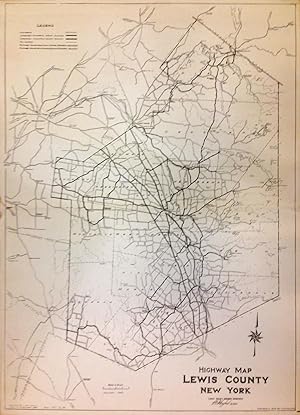
Highway Map Lewis County New York
Verlag: Lewis County Highway Department, New York, 1940
Anbieter: Argosy Book Store, ABAA, ILAB, New York, NY, USA
Verkäuferbewertung 5 von 5 Sternen
unbound. Map. Sheet measures 32.5" x 23.5". This lovely 1940 map of Lewis County, New York beautifully covers the entire county in detail, noting railways, towns, rivers, and highways. Improved and future state and county highways are also detailed. The map was reduced from the U.S. Geological Survey sheets traced by W. Galloway in 1928. Issued by the Lewis County Highway Department and copyrighted to 1940 by L.P.M. Gaylord. The map is in good condition with minor wear along the original folds Some edge wear and toning. Damage near centerfold left margin, with some rips and discoloration. The map celebrates highway design before the Interstate Highway system was started.
