
Gesamtpreis (1 Artikel Artikel):
Versandziel:

american artist publishing company (7 Ergebnisse)
Feedback
Direkt zu den wichtigsten Suchergebnissen
Suchfilter
Produktart
- Alle Product Types
- Bücher (6)
- Magazine & Zeitschriften (Keine weiteren Ergebnisse entsprechen dieser Verfeinerung)
- Comics (Keine weiteren Ergebnisse entsprechen dieser Verfeinerung)
- Noten (Keine weiteren Ergebnisse entsprechen dieser Verfeinerung)
- Kunst, Grafik & Poster (1)
- Fotografien (Keine weiteren Ergebnisse entsprechen dieser Verfeinerung)
- Karten (Keine weiteren Ergebnisse entsprechen dieser Verfeinerung)
- Manuskripte & Papierantiquitäten (Keine weiteren Ergebnisse entsprechen dieser Verfeinerung)
Zustand
- Alle
- Neu (Keine weiteren Ergebnisse entsprechen dieser Verfeinerung)
- Antiquarisch (7)
Einband
- alle Einbände
- Hardcover (Keine weiteren Ergebnisse entsprechen dieser Verfeinerung)
- Softcover (2)
Weitere Eigenschaften
- Erstausgabe (Keine weiteren Ergebnisse entsprechen dieser Verfeinerung)
- Signiert (Keine weiteren Ergebnisse entsprechen dieser Verfeinerung)
- Schutzumschlag (Keine weiteren Ergebnisse entsprechen dieser Verfeinerung)
- Angebotsfoto (5)
Gratisversand
- Kostenloser Versand nach Deutschland (Keine weiteren Ergebnisse entsprechen dieser Verfeinerung)
Verkäuferbewertung
-
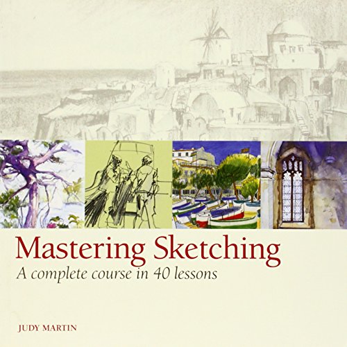
Mastering Sketching : A Complete Course in 40 Lessons
Verlag: American Artist Publishing Company, 2011
ISBN 10: 1596682809 ISBN 13: 9781596682801
Anbieter: Better World Books, Mishawaka, IN, USA
Verkäuferbewertung 5 von 5 Sternen

Zustand: Good. Used book that is in clean, average condition without any missing pages.
-
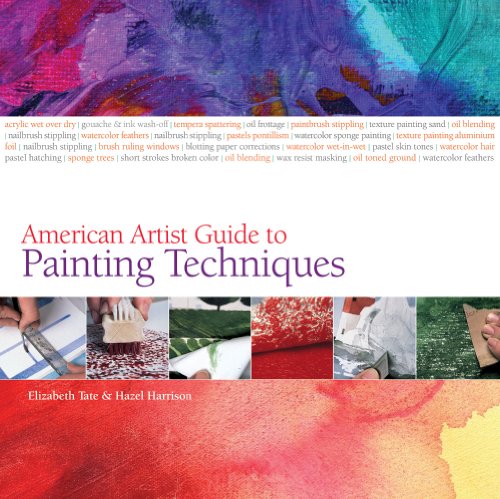
American Artist Guide to Painting Techniques
Verlag: American Artist Publishing Company, 2011
ISBN 10: 1596682795 ISBN 13: 9781596682795
Anbieter: Better World Books, Mishawaka, IN, USA
Verkäuferbewertung 5 von 5 Sternen
Zustand: Good. Former library book; may include library markings. Used book that is in clean, average condition without any missing pages.
-
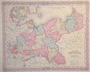
Colton's Prussia and Saxony.
Verlag: Artist: Colton/Hutchins Joseph ( - 1893 ) New York ; issued in: New York; - Joseph Hutchins Colton (1800 ?1893) known professionally as JH Colton founded an American mapmaking company which was an international leader in the map publishing industry between 1831 and 1890 For the first ten years Colton licensed the use of maps from established cartographers such as David H Burr Colton also employed some of the preeminent engravers of the time including Burr Samuel Stiles John Disturnell and D Griffing Johnson Colton went on to create railroad maps immigrant guides folding pocket maps large wall maps and elaborate atlases, 1800
Anbieter: Antique Sommer& Sapunaru KG, München, Deutschland
Verkäuferbewertung 4 von 5 Sternen

Technic: Steel engraving, colorit: original colored, condition: Perfect condition, size (in cm): 32 x 40 cm; - Surrounded by Colton's typical spiral motif border. Kaliningrad/Königsberg, Gda_sk/Danzig, Bromburg/Bydgoszcz, Posen, Wroc_aw/Breslau, Opole/Oppeln, Gorlitz, Dresden, Leipzig, Frankfurt (Oder), Szczecin/Stettin, Stralsund,Berlin, Magdeburg, Merseburg and Erfurt?; History: Prussia: The name Prussia derives from the Old Prussians; in the 13th century, the Teutonic Knights?an organized Catholic medieval military order of German crusaders?conquered the lands inhabited by them. It was a historically prominent German state that originated in 1525 with a duchy centred on the region of Prussia on the southeast coast of the Baltic Sea. It was de facto dissolved by an emergency decree transferring powers of the Prussian government to German Chancellor Franz von Papen in 1932 and de jure by an Allied decree in 1947. For centuries, the House of Hohenzollern ruled Prussia, successfully expanding its size by way of an unusually well-organised and effective army. Prussia, with its capital in Königsberg and from 1701 in Berlin, decisively shaped the history of Germany. The Thirteen Years' War (1454?1466) began when the Prussian Confederation, a coalition of Hanseatic cities of western Prussia, rebelled against the Order and requested help from the Polish king, Casimir IV Jagiellon. The Teutonic Knights were forced to acknowledge the sovereignty of, and to pay tribute to Casimir IV in the Second Peace of Thorn (1466), losing western Prussia (Royal Prussia) to Poland in the process. Pursuant to the Second Peace of Thorn, two Prussian states were established. In 1701, Frederick William's son, Elector Frederick III, upgraded Prussia from a duchy to a kingdom and crowned himself King Frederick I. In the Crown Treaty of 16 November 1700, Leopold I, emperor of the Holy Roman Empire, allowed Frederick only to title himself "King in Prussia", not "King of Prussia". The state of Brandenburg-Prussia became commonly known as "Prussia", although most of its territory, in Brandenburg, Pomerania, and western Germany, lay outside Prussia proper. The Prussian state grew in splendour during the reign of Frederick I, who sponsored the arts at the expense of the treasury. During the reign of King Frederick William II (1786?1797), Prussia annexed additional Polish territory through further Partitions of Poland. His successor, Frederick William III (1797?1840), announced the union of the Prussian Lutheran and Reformed churches into one church.
-
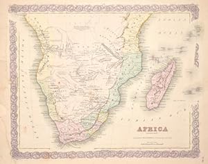
Africa (Sothern Sheet.)
Verlag: Artist: Colton/Hutchins Joseph ( - 1893 ) New York ; issued in: New York; - Joseph Hutchins Colton (1800 ?1893) known professionally as JH Colton founded an American mapmaking company which was an international leader in the map publishing industry between 1831 and 1890 For the first ten years Colton licensed the use of maps from established cartographers such as David H Burr Colton also employed some of the preeminent engravers of the time including Burr Samuel Stiles John Disturnell and D Griffing Johnson Colton went on to create railroad maps immigrant guides folding pocket maps large wall maps and elaborate atlases, 1800
Anbieter: Antique Sommer& Sapunaru KG, München, Deutschland
Verkäuferbewertung 4 von 5 Sternen
Technic: Lithography, colorit: original colored, condition: Tears at the external margin restored, size (in cm): 32 x 41 cm; - Map shows South Africa to the equator with Madagascar, the Seychelles, the Amirantes, Mauritius and the island of Reunion in the Indian Ocean.; History: Some of the world's oldest paleoanthropological fossils have been unearthed in South Africa. After these pre-humans, various species of the Homo genus such as Homo habilis, Homo naledi, Homo erectus and finally modern man, Homo sapiens, lived here. The beginning of modern historiography in South Africa is set on April 6, 1652, when the Dutchman Jan van Riebeeck built a supply station on the Cape of Good Hope on behalf of the Dutch East India Company (Dutch Vereenigde Oostindische Compagnie, VOC). Due to its strategically favorable location, it was supposed to be a rest stop for merchant ships traveling between Europe and Southeast Asia. During the 17th and 18th centuries, the settlement, which slowly but steadily expanded, was owned by the Netherlands. The settlers initially spread to the western Cape region, which at that time was a retreat for the Khoisan. Several hundred French Huguenots, after being persecuted in France from 1686, came into the country via the Netherlands from 1688 and brought the viticulture culture with them. The French-speaking names of wineries and fruit-growing farms in the western Cape can be traced back to them. After reaching the Bantu settlement border eastwards in 1770, they waged a series of wars - the border wars - against the Xhosa people. The Cape Dutch brought numerous slaves into the country from Indonesia, Madagascar and India.
-

New Brunswick Nova Scotia , Newfoundland and Prince Edward Id.
Verlag: Artist: Colton/Hutchins Joseph ( - 1893 ) New York ; issued in: ; - Joseph Hutchins Colton (1800 ?1893) known professionally as JH Colton founded an American mapmaking company which was an international leader in the map publishing industry between 1831 and 1890 For the first ten years Colton licensed the use of maps from established cartographers such as David H Burr Colton also employed some of the preeminent engravers of the time including Burr Samuel Stiles John Disturnell and D Griffing Johnson Colton went on to create railroad maps immigrant guides folding pocket maps large wall maps and elaborate atlases, 1800
Anbieter: Antique Sommer& Sapunaru KG, München, Deutschland
Verkäuferbewertung 4 von 5 Sternen
Technic: Lithography, colorit: colored, condition: Very good, size (in cm): 32,5 x 40; - Map shows Nova Scotia, New Foundland and the Prince Edward island.
-
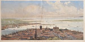
What the "Jubilee Shot" could do in New York.
Verlag: Artist: Harper and Brothers ( - 1916 ) New York ; issued in: New York; - Harper is an American publishing house currently the flagship imprint of global publisher HarperCollins based in New York City James Harper and his brother John printers by training started their book publishing business J & J Harper in New York City on 1817 Their two brothers Joseph Wesley Harper and Fletcher Harper joined them in the mid-1820s The company changed its name to "Harper & Brothers" in 1833 The headquarters of the publishing house were located at 331 Pearl Street facing Franklin Square in Lower Manhattan Harper's New Monthly Magazine ultimately became Harper's Magazine which is now published by the Harper's Magazine Foundation, 1857
Anbieter: Antique Sommer& Sapunaru KG, München, Deutschland
Verkäuferbewertung 4 von 5 Sternen
Kunst / Grafik / Poster
Technic: Wood engraving, colorit: colored, condition: Tears at the external margin restored, size (in cm): 25 x 49,5; - Bird s eye view of New York with Manhatten, view toward the ocean.; History: First voyages of discovery to the area of today's New York took place in 1524 by Giovanni da Verrazzano and in 1609 by Henry Hudson. Starting in 1610, Dutch merchants began a lucrative fur trade with the Indians living there. In March 1614, the newly formed Compagnie van Nieuwnederlant (New Netherland Company) was granted a monopoly by the States General to trade in the area. In October 1618, ten months after the trade monopoly expired, the company applied for a new charter. At that time, however, the States General were already considering the creation of a new company, the Dutch West India Company (WIC). On June 3, 1621, the WIC received a charter from the Republic of the Seven United Provinces to trade solely in the Americas. Colonization began in 1624 when 30 Dutch, Walloon and French families settled on Manhattan Island and in the Delaware area. According to legend, in 1626 Peter Minuit bought the island from the natives, probably a branch of the Lenni-Lenape Indians who called the island "Manna-hatta", for 60 guilders.The newly founded settlement was named Nieuw Amsterdam and became the capital of the colony of Nieuw Nederland.Chaotic conditions soon prevailed in the settlement. Under the rule of corrupt governors, crime increased enormously.In 1647, the Dutch West India Company decided to restore order. Petrus Stuyvesant was to take on this task. During his 17-year term as governor, the first hospital, the first prison and the first school were built. As protection against raids, he had a wall built across the island to the north of the city in 1652, which would later give its name to the street running along it, Wall Street. On February 2, 1653, Nieuw Amsterdam received its city charter. On September 8, 1664, the city surrendered without a fight to a Royal Navy fleet led by Richard Nicolls.The English named the city and the colony of New York after their then commander James, Duke of York, brother of Charles II of England, who later became king himself. In 1667, the Dutch relinquished all claims to the colony in the Peace of Breda, in which they were granted rights to Suriname in exchange. In the ensuing Third Anglo-Dutch War, the Dutch briefly retook the colony in 1673 through Cornelis Evertsen before finally having to surrender the land by signing the Treaty of Westminster on February 19, 1674. From 1788 to 1790, New York was the capital of the United States. George Washington was sworn in as the first president on the balcony of New York's Federal Hall in 1789. In the difficult economic times following the war, securities traders established the New York Stock Exchange on May 17, 1792. On April 13, 1796, the first elephant in America arrived in New York Harbor. In 1797, Albany was designated the capital of New York State instead of New York and remains so today.
-

Oceanica, Map Nr. 22 Coltons Common School Geography
Verlag: Artist: Colton/Hutchins Joseph ( - 1893 ) New York ; issued in: New York; - Joseph Hutchins Colton (1800 ?1893) known professionally as JH Colton founded an American mapmaking company which was an international leader in the map publishing industry between 1831 and 1890 For the first ten years Colton licensed the use of maps from established cartographers such as David H Burr Colton also employed some of the preeminent engravers of the time including Burr Samuel Stiles John Disturnell and D Griffing Johnson Colton went on to create railroad maps immigrant guides folding pocket maps large wall maps and elaborate atlases, 1800
Anbieter: Antique Sommer& Sapunaru KG, München, Deutschland
Verkäuferbewertung 4 von 5 Sternen
Technic: Wood engraving, colorit: colored, condition: Perfect condition, size (in cm): 21 x 27 cm; - Map shows total Oceania with Australia, New Zealand and Southeast Asia. on reverse 2 views of Oasis and Port Louis on Mauritius.; History: Oceania is the name for the island world of the Pacific north and east of the continent of Australia. In English, the term transoceania is also used. This term originated mainly for economic reasons in Australia and New Zealand and describes an area from northern Australia via Indonesia to the southern border of the Philippines and the far west of the Pacific islands. The term "South Sea" was coined in 1513 by Vasco Núńez de Balboa, when he had crossed the isthmus of Panama and called the sea (Pacific) in front of him Mar del sur (South Sea), as he was facing south from his location looked. Central island groups are the Society Islands (French Polynesia / Tahiti), the Samoa Archipelago and the Fiji Islands. In November 1520 Ferdinand Magellan, coming from the Strait of Magellan, reached the Pacific or the Pacific Ocean while circumnavigating the world. He called it Mar Pacifico (Portuguese and Spanish for Peaceful Seas) because the storms that had accompanied it until then subsided. Despite this name, there are also violent storms and cyclones in the Pacific, which are called typhoon or hurricane depending on the region. The spirit of discovery of the 16th century is decisive for numerous expeditions. The first focus is on exploring a western route across the Pacific to the rich trading centers of Asia. Later, mainly Spanish and Portuguese adventurers search for the hypothetical southern continent Terra Australis Incognita or hope to find legendary riches such as the mines of King Solomon. Due to inadequate navigation techniques, some of the island groups discovered, e.g. B. the Solomon Islands, cannot be found again and fell into oblivion. At the end of the 16th century, the Dutch began exploring Oceania too. In the 17th century there is still a lot undiscovered in the Pacific and, above all, the stories of those returning home from Paradise attract more and more sailors. The motivation to travel to new worlds is great, but goes hand in hand with the greed for the pristine natural resources of the new world. The church is meanwhile worried about the "mixing" with the heathen peoples, but is nevertheless interested in the salvation of the "savages". She reacts by publicly discrediting the fornication with the inhabitants and delegating missionaries to assist with the trips. In the 18th century there were less and less available on undiscovered islands, but circumnavigators like Louis Antoine de Bougainville, James Cook and others still found some unexplored areas. In addition, some of the discoveries made in the 16th century were forgotten again. Some now set about mapping the islands using modern means. In the 18th century, mapping continued and imperialism is beginning to take effect. Foreign island groups are increasingly being divided up among the great powers. The colonization of the South Pacific is becoming a race. Above all, Germans, British, French, Dutch and Americans fight over every island. At the end of the 19th century, the Spanish-American War led to a wild castling of the colonial territories.