
Gesamtpreis (1 Artikel Artikel):
Versandziel:

survey cyprus motor map eighth (1 Ergebnisse)
Direkt zu den wichtigsten Suchergebnissen
Suchfilter
Produktart
- Alle Product Types
- B³cher (Keine weiteren Ergebnisse entsprechen dieser Verfeinerung)
- Magazine & Zeitschriften (Keine weiteren Ergebnisse entsprechen dieser Verfeinerung)
- Comics (Keine weiteren Ergebnisse entsprechen dieser Verfeinerung)
- Noten (Keine weiteren Ergebnisse entsprechen dieser Verfeinerung)
- Kunst, Grafik & Poster (Keine weiteren Ergebnisse entsprechen dieser Verfeinerung)
- Fotografien (Keine weiteren Ergebnisse entsprechen dieser Verfeinerung)
- Karten (1)
- Manuskripte & Papierantiquitõten (Keine weiteren Ergebnisse entsprechen dieser Verfeinerung)
Zustand Mehr dazu
- Neu (Keine weiteren Ergebnisse entsprechen dieser Verfeinerung)
- Wie Neu, Sehr Gut oder Gut Bis Sehr Gut (Keine weiteren Ergebnisse entsprechen dieser Verfeinerung)
- Gut oder Befriedigend (Keine weiteren Ergebnisse entsprechen dieser Verfeinerung)
- Ausreichend oder Schlecht (Keine weiteren Ergebnisse entsprechen dieser Verfeinerung)
- Wie beschrieben (1)
Einband
- alle Einbõnde
- Hardcover (Keine weiteren Ergebnisse entsprechen dieser Verfeinerung)
- Softcover (Keine weiteren Ergebnisse entsprechen dieser Verfeinerung)
Weitere Eigenschaften
- Erstausgabe (Keine weiteren Ergebnisse entsprechen dieser Verfeinerung)
- Signiert (Keine weiteren Ergebnisse entsprechen dieser Verfeinerung)
- Schutzumschlag (Keine weiteren Ergebnisse entsprechen dieser Verfeinerung)
- Angebotsfoto (1)
Sprache (1)
Preis
- Beliebiger Preis
- Weniger als EUR 20 (Keine weiteren Ergebnisse entsprechen dieser Verfeinerung)
- EUR 20 bis EUR 45 (Keine weiteren Ergebnisse entsprechen dieser Verfeinerung)
- Mehr als EUR 45
Gratisversand
- Kostenloser Versand nach USA (Keine weiteren Ergebnisse entsprechen dieser Verfeinerung)
Land des Verkõufers
Verkõuferbewertung
-
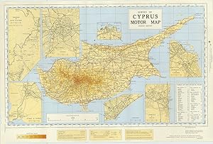
Survey of Cyprus Motor Map. Eighth Edition.
Verlag: Chessington SurreyPrinted by the Director General of the Ordnance Survey.for the Government of Cyprus ., 1965
Anbieter: Robert Frew Ltd. ABA ILAB, London, Vereinigtes K÷nigreich
Verbandsmitglied: ABA ILAB PBFA
Verkõuferbewertung 5 von 5 Sternen

Karte
EUR 89,43
EUR 11,58 Versand
Versand von Vereinigtes K÷nigreich nach USAAnzahl: 1 verf³gbar
In den WarenkorbOverall dimensions 37 x 56 cm. Folding colour printed map of Cyprus, scale: eight inches to one mile. Seven inset maps (all except one on a scale of the two inches to one mile) and a table of distances, folded between original printed card covers, the upper board featuring a view of Bellapais Abbey. Excellent condition. The inset maps feature: Trodos & Pano Platres; Nicosia; Ktima & Paphos; Limassol; Larnaca & Scala; Famagusta & Varosha. Prepared originally in the Drawing Office of the Dept. of Lands & surveys, Cyprus, 1932, Eighth Edition redrawn 1965.