Gesamtpreis (1 Artikel Artikel):
Versandziel:

rare original plan map north (2 Ergebnisse)
Direkt zu den wichtigsten Suchergebnissen
Suchfilter
Produktart
- Alle Product Types
- Bücher (1)
- Magazine & Zeitschriften (Keine weiteren Ergebnisse entsprechen dieser Verfeinerung)
- Comics (Keine weiteren Ergebnisse entsprechen dieser Verfeinerung)
- Noten (Keine weiteren Ergebnisse entsprechen dieser Verfeinerung)
- Kunst, Grafik & Poster (Keine weiteren Ergebnisse entsprechen dieser Verfeinerung)
- Fotografien (Keine weiteren Ergebnisse entsprechen dieser Verfeinerung)
- Karten (1)
- Manuskripte & Papierantiquitäten (Keine weiteren Ergebnisse entsprechen dieser Verfeinerung)
Zustand Mehr dazu
- Neu (Keine weiteren Ergebnisse entsprechen dieser Verfeinerung)
- Wie Neu, Sehr Gut oder Gut Bis Sehr Gut (Keine weiteren Ergebnisse entsprechen dieser Verfeinerung)
- Gut oder Befriedigend (2)
- Ausreichend oder Schlecht (Keine weiteren Ergebnisse entsprechen dieser Verfeinerung)
- Wie beschrieben (Keine weiteren Ergebnisse entsprechen dieser Verfeinerung)
Einband
- alle Einbände
- Hardcover (Keine weiteren Ergebnisse entsprechen dieser Verfeinerung)
- Softcover (Keine weiteren Ergebnisse entsprechen dieser Verfeinerung)
Weitere Eigenschaften
- Erstausgabe (1)
- Signiert (Keine weiteren Ergebnisse entsprechen dieser Verfeinerung)
- Schutzumschlag (Keine weiteren Ergebnisse entsprechen dieser Verfeinerung)
- Angebotsfoto (2)
Sprache (1)
Preis
- Beliebiger Preis
- Weniger als EUR 20 (Keine weiteren Ergebnisse entsprechen dieser Verfeinerung)
- EUR 20 bis EUR 45 (Keine weiteren Ergebnisse entsprechen dieser Verfeinerung)
- Mehr als EUR 45
Gratisversand
- Kostenloser Versand nach USA (Keine weiteren Ergebnisse entsprechen dieser Verfeinerung)
Land des Verkäufers
Verkäuferbewertung
-
RARE ORIGINAL PLAN Map NORTH EASTERN RAILWAY AND PONTEFRACT RURAL DISTRICT COUNCIL A SURVEY PLAN SHOWING The LEVEL CROSSING at NEW FRYSTON Colliery CASTLEFORD WEST YORKSHIRE 1900
Verlag: NORTH EASTERN RAILWAY AND PONTEFRACT RURAL DISTRICT COUNCIL, CASTLEFORD WEST YORKSHIRE, 1900
Anbieter: Andrew Cox PBFA, Shropshire, Vereinigtes Königreich
Verbandsmitglied: PBFA
Verkäuferbewertung 5 von 5 Sternen

Erstausgabe
EUR 77,51
EUR 22,58 Versand
Versand von Vereinigtes Königreich nach USAAnzahl: 1 verfügbar
In den WarenkorbNo Binding. Zustand: Good. 1st Edition. This is a rare old large format plan produced by Richardson & Le Maitre of Leeds for The North Eastern Railway centred on the Level Crossing at New Fryston, the plan is a large format printed on very tightly woven strong paper that has the appearance of thin cloth, measuring 38 inches by 29 inches approx., the plan takes in part of the River Aire, Mills Arms Public House, Fryston House, Fryston Colliery and the Colliery Railway Sidings, Wellington Street, Oxford Street, Castle Street, Hope Street, Smith Street William Street, showing each of the properties in those streets, The Church and School, Wheldale Wood Lime Works, the Railway Signal box and Level crossing, etc the plan has been folded for many years leaving strong crease marks, I am sure these could be flattened out if desired, some mild browning else in good condition.
-
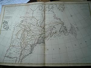
Carte Nouvelle de l'Amerique Angloise Contenant la Virginie, Mary-Land, Caroline, Pensylvania, Nouvelle Iorck, N: Iarsey N: France, et les Terres Nouvellement Decoverte . . .' (with an inset map of Boston Harbor) A very fine example of this detailed 2-sheet map of the British Colonies in North America, drawn directly from Robert Morden's rare and important 'New Map of the English Empire In America', that was first published in circa 1698 in London. Printed on thick paper in original publishers colours. Onli little brownish. Size of the sheet: 63 x 98 cm. From the first edition anno 1700. Burden identifies the map as "the first printed plan of an English colonial city in a non-English map." Burden notes: The most notable feature here is
Erscheinungsdatum: 1700
Anbieter: Hammelburger Antiquariat, Hammelburg, Deutschland
Verkäuferbewertung 5 von 5 Sternen
Karte
EUR 3.500,00
EUR 30,00 Versand
Versand von Deutschland nach USAAnzahl: 1 verfügbar
In den WarenkorbKein Einband. Zustand: Gut. Carte Nouvelle de l'Amerique Angloise Contenant la Virginie, Mary-Land, Caroline, Pensylvania, Nouvelle Iorck, N: Iarsey N: France, et les Terres Nouvellement Decoverte . . .' (with an inset map of Boston Harbor) A very fine example of this detailed 2-sheet map of the British Colonies in North America, drawn directly from Robert Morden's rare and important 'New Map of the English Empire In America', that was first published in circa 1698 in London. Printed on thick paper in original publishers colours. Onli little brownish. Size of the sheet: 63 x 98 cm. From the first edition anno 1700. Burden identifies the map as "the first printed plan of an English colonial city in a non-English map." Burden notes: The most notable feature here is the mountain range extending from the Florida peninsula northwards into Michigan. This plateau remains, although the legend found on the Morden describing [the mountain range] does not. The original source for this curious feature is unknown. . . the map's English origins are clearly seen, including the Copper Mine near present day Chicago, and Mines of Iron besides the Ohio River, both originating from Thevenot, 1681. The unusual depiction of Green Bay, the broader northern portion of the Delaware peninsula, the boundaries of Pennsylvania extending far to the north, the altered Cape Cod and the inset plan of Boston Harbor are all features found on the Morden map. The map focuses on the British Colonies in North America and illustrates several popular geographical misconceptions of the late 17th Century. There is a strange mountain range in Florida, and the mouth of the Mississippi River is pushed too far to the west, into Texas. This feature appeared on maps for only about 30 years, the result of a hoax perpetrated by La Salle in an attempt to make a settlement at the mouth of the river look strategically important-in being near to the Spanish ports in Mexico-thus lending added weight to his plan of developing a French Empire along the great North American inland waterways. Also shown are the three notorious errors derived from the reports of John Lederer: 'Ashley Lake,' the 'Savana,' and the 'Desert Arenosa,'. References: Burden II, number 765.