
Gesamtpreis (1 Artikel Artikel):
Versandziel:

polynesia islands pacific ocean von rapkin (12 Ergebnisse)
Direkt zu den wichtigsten Suchergebnissen
Produktart
- Alle Produktarten
- Bücher (8)
- Magazine & Zeitschriften
- Comics
- Noten
- Kunst, Grafik & Poster
- Fotografien
- Karten (4)
-
Manuskripte &
Papierantiquitäten
Zustand
- Alle
- Neu
- Antiquarisch/Gebraucht
Einband
- alle Einbände
- Hardcover
- Softcover
Weitere Eigenschaften
- Erstausgabe
- Signiert
- Schutzumschlag
- Angebotsfoto
Land des Verkäufers
Verkäuferbewertung
-
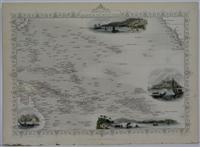
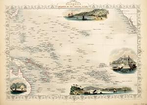
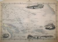
Polynesia, Islands of the Pacific Ocean
Verlag: John Tallis & Company, London & New York, 1849
Anbieter: Alexandre Antique Prints, Maps & Books, Toronto, ON, Kanada
Bewertung:

Karte
Zustand: Very Good. A Charming 19th century depiction of Polynesia. Vignettes surrounding the map are beautifully coloured., Size : 235x345 (mm), 9.25x13.625 (Inches), Original Outline Coloring.
-
Polynesia or Islands in the Pacific Ocean.
Verlag: The Illustrated Atlas and Modern History of the World Geographical, Political, Commercial & Statistical. John Tallis & Company. 1850, 1850
Anbieter: Peter Harrington. ABA/ ILAB., London, Vereinigtes Königreich
Verbandsmitglied: ABA ILAB PBFA
Bewertung:

A highly decorative map for the period with vignettes showing towns and local scenes, the whole enclosed in an elegant border. Steel engraving. Original outline colour, later additions. Good condition. Central vertical fold and light browning.
-
Polynesia or Islands in the Pacific Ocean.
Verlag: The Illustrated Atlas and Modern History of the World Geographical, Political, Commercial & Statistical. John Tallis & Company. 1850, 1850
Anbieter: Peter Harrington. ABA/ ILAB., London, Vereinigtes Königreich
Verbandsmitglied: ABA ILAB PBFA
Bewertung:
A highly decorative map for the period with vignettes showing towns and local scenes, the whole enclosed in an elegant border. Steel engraving. Original outline colour, later additions. Good condition. Central vertical fold and light browning.
-
Polynesia or Islands in the Pacific Ocean
Verlag: The Illustrated Atlas and Modern History of the World Geographical, Political, Commercial & Statistical. John Tallis & Company. 1850, 1850
Anbieter: Peter Harrington. ABA/ ILAB., London, Vereinigtes Königreich
Verbandsmitglied: ABA ILAB PBFA
Bewertung:
A highly decorative map for the period with vignettes showing towns and local scenes, the whole enclosed in an elegant border. Steel engraving. Original outline colour, later additions. Good condition. Central vertical fold and light browning. Size: 35 x 26 cm. (14 x 10 inches).
-
Polynesia or Islands in the Pacific Ocean
Verlag: The Illustrated Atlas and Modern History of the World Geographical, Political, Commercial & Statistical. John Tallis & Company. 1850, 1850
Anbieter: Peter Harrington. ABA/ ILAB., London, Vereinigtes Königreich
Verbandsmitglied: ABA ILAB PBFA
Bewertung:
A highly decorative map for the period with vignettes showing towns and local scenes, the whole enclosed in an elegant border. Steel engraving. Original outline colour, later additions. Good condition. Top margin cropped, not affecting title. Size: 35 x 26 cm. (14 x 10 inches).
-
Polynesia or Islands in the Pacific Ocean.
Verlag: The Illustrated Atlas and Modern History of the World, Geographical, Political, Commercial & Statistical. John Tallis & Company, 1850, 1850
Anbieter: Peter Harrington. ABA/ ILAB., London, Vereinigtes Königreich
Verbandsmitglied: ABA ILAB PBFA
Bewertung:
A highly decorative map for the period with vignettes showing towns and local scenes, the whole enclosed in an elegant border. Steel engraving. Original outline colour, later additions. Good condition. Top margin cropped, not affecting title.
-
Polynesia or Islands in the Pacific Ocean.
Verlag: The Illustrated Atlas and Modern History of the World Geographical, Political, Commercial & Statistical. John Tallis & Company. 1850, 1850
Anbieter: Peter Harrington. ABA/ ILAB., London, Vereinigtes Königreich
Verbandsmitglied: ABA ILAB PBFA
Bewertung:
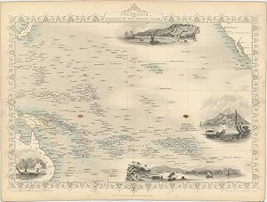
A highly decorative map for the period with vignettes showing Kalakakooa, Sandwich Islands; Otaheite; Harbour of Dory, New Guinea; Resolution Bay, Marquesas, the whole enclosed in an elegant border. Steel engraving. Original outline colour, later additions. In fine condition. Size: 35 x 26 cm. (14 x 10 inches).
-
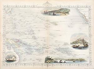
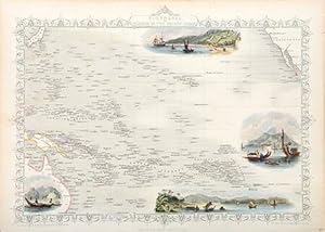
Polynesia, or Islands in the Pacific ocean.
Verlag: Artist: Rapkin J ; issued in: London ; ca: ; -, 1850
Anbieter: Antique Sommer& Sapunaru KG, München, Deutschland
Bewertung:
Technic: Steel engraving; colorit: original colored; condition: Perfect condition, size (in cm): 25,5 x 35,5 cm; - Map shows all of Polynesia, French Polynesia, Micronesia, Melanesia, partly Australia, Japan and California. Furthermore 4 views of Otaheite (Tahiti), Kalakakooa (Sandwich Islands), New Guinea and the Tahuata Island (Marquesas Islands).
-
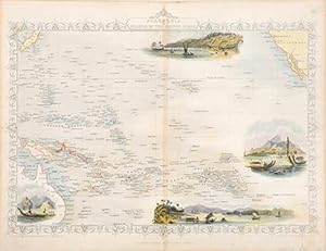
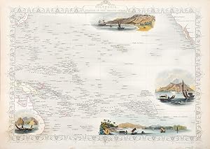
Polynesia, or Islands in the Pacific Ocean
Verlag: John Tallis, London, 1851
Anbieter: Antipodean Books, Maps & Prints, ABAA, Garrison, NY, USA
Verbandsmitglied: ABAA ANZAAB ESA ILAB
Bewertung:

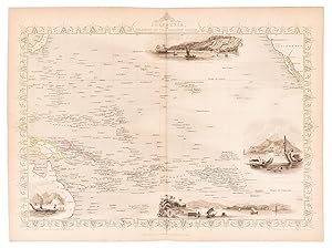
Maps. Steel engraved map with period outline colour. Attractive vignette views include Kalakakoa (Karakakoa) Bay, site of Cook's death, Otahiti, Harbour of Doree (New Guinea), Resolution Bay, Marquesas. Extends from Sydney in the South to Yedo, Japan in the North, San Francisco to Easter Island.
-
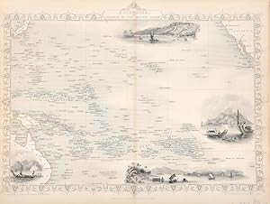
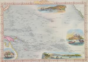
Polynesia, or the Islands in the Pacific Ocean.
Verlag: London & New YorkJohn Tallis & Company -1856., 1851
Anbieter: Robert Frew Ltd. ABA ILAB, London, Vereinigtes Königreich
Verbandsmitglied: ABA ILAB PBFA
Bewertung:
Karte
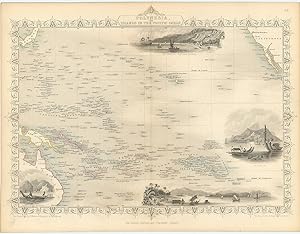
Original steel engraved map, with several vignette scenes showing Resolution Bay in the Marquesas, Kalakakooka in the Sandwich Islands, Dory in New Guinea and Ortaheite in the Society Islands. Decorative scrolling and title cartouche around the edges of the image. (Map 22 x 29.5 cm, overall sheet 27.5 x 36 cm). Original outline colour. Centrefold crease as issued. A few brown spots, otherwise good. For the Great Exhibition in 1851 John Tallis (1817-1876) worked with engraver John Rapkin (1815-1876) to publish the 'Illustrated World Atlas', whose maps were later re-issued by the London Printing and Publishing Company under the Tallis imprint. Their maps are prized for their wonderful steel-engraved vignettes showing the peoples, customs, architecture, landmarks, flora, and fauna of each country.
-
Polynesia, or the Islands in the Pacific Ocean.
Verlag: London & New YorkJohn Tallis & Company -1856., 1851
Anbieter: Robert Frew Ltd. ABA ILAB, London, Vereinigtes Königreich
Verbandsmitglied: ABA ILAB PBFA
Bewertung:
Karte
Original steel engraved map, with several vignette scenes showing Resolution Bay in the Marquesas, Kalakakooka in the Sandwich Islands, Dory in New Guinea and Ortaheite in the Society Islands. Decorative scrolling and title cartouche around the edges of the image. (Map 22 x 29.5 cm, overall sheet 27.5 x 36 cm). Original outline colour. Centrefold crease as issued. In very good condition. For the Great Exhibition in 1851 John Tallis (1817-1876) worked with engraver John Rapkin (1815-1876) to publish the 'Illustrated World Atlas', whose maps were later re-issued by the London Printing and Publishing Company under the Tallis imprint. Their maps are prized for their wonderful steel-engraved vignettes showing the peoples, customs, architecture, landmarks, flora, and fauna of each country.
-
Polynesia, or the Islands in the Pacific Ocean.
Verlag: The London Printing and Publishing Company -1856., 1851
Anbieter: Robert Frew Ltd. ABA ILAB, London, Vereinigtes Königreich
Verbandsmitglied: ABA ILAB PBFA
Bewertung:
Karte
Original steel engraved map, with several vignette scenes showing Resolution Bay in the Marquesas, Kalakakooka in the Sandwich Islands, Dory in New Guinea and Ortaheite in the Society Islands. Decorative scrolling and title cartouche around the edges of the image. (Map 22 x 29.5 cm, overall sheet 27.5 x 36 cm). Original outline colour. Centrefold crease as issued. Excellent condition. For the Great Exhibition in 1851 John Tallis (1817-1876) worked with engraver John Rapkin (1815-1876) to publish the 'Illustrated World Atlas', whose maps were later re-issued by the London Printing and Publishing Company under the Tallis imprint. Their maps are prized for their wonderful steel-engraved vignettes showing the peoples, customs, architecture, landmarks, flora, and fauna of each country.