
Plan von thomas david (7 Ergebnisse)

- Softcover
Anbieter: Ria Christie Collections, Uxbridge, Vereinigtes KönigreichRia Christie Collections
Verkäufer/-in kontaktierenVerkäufer/-in mit 5 SternenZustand: Neu
EUR 15,95
EUR 14,02 VersandVersand von Vereinigtes Königreich nach USAAnzahl: Mehr als 20 verfügbar
Zustand: New. In.
Verlag: D.T. Valentine, New York, 1854
Anbieter: Argosy Book Store, ABAA, ILAB, New York, NY, USAArgosy Book Store, ABAA, ILAB
Verkäufer/-in kontaktierenVerkäufer/-in mit 5 SternenZustand: Gebraucht
EUR 86,01
EUR 5,27 VersandVersand innerhalb von USAAnzahl: 1 verfügbar
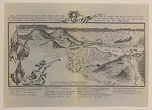
In den WarenkorbMap. Lithograph. Sheet measures 5 5/8" x 8" This small facsimile map was based on an earlier Revolutionary war era view by Wilhelm von Knyphausen, reproduced for the 1854 issue of "Manual of The Corporation of the City of New York." It depicts the northern tip of Manhattan, showing the rugged terrain near Spuyten Devil, and the…Hudson River and New Jersey Palisades in the foreground. Along the right side of the map, the view extends along the East River, showing parts of the Bronx. Many major buildings, fortifications, and encampments are labeled. Topography (including marshlands and wooded areas) as well as structures are rendered pictorially. It is in very good condition with minor yellowing to original centerfold. David Thomas Valentine (1801-1869) served as the Deputy to the Clerk of the Common Council for thirty-seven years and began publishing the "Manual for the Corporation of the City of New York" in 1841. The Manuals were directories of extensive historical and contemporary records of New York that included facts about the City of New York, city history, city council information, and reported on the progress of public works such as Central Park. Popularly called Valentine's Manuals, the texts were richly illustrated with maps, lithographs, and engravings. This map provides a fascinating look at the rapid development of New York City. G. Hayward (illustrator).

The Duke's Plan. A Description of the Towne of Mannados or New Amsterdam as it was in September 1661
Verlag: Argosy Gallery, New York
Anbieter: Argosy Book Store, ABAA, ILAB, New York, NY, USAArgosy Book Store, ABAA, ILAB
Verkäufer/-in kontaktierenVerkäufer/-in mit 5 SternenZustand: Gebraucht
EUR 90,53
EUR 5,27 VersandVersand innerhalb von USAAnzahl: 3 verfügbar
In den Warenkorbunbound. Map. Vintage reproduction, circa 1970. Sheet measures 24" x 29 1/4" This wonderful and famous map of the Manhattan was included in the 1859 edition of Valentine's Manual of the Corporation of New York. Considered a kind of trophy of the English conquest in 1664, the map depicts the Dutch colony of New Amsterdam in its f…inal moments, as it was in 1661. It's name refers to James, the Duke of York, who was gifted the colony by King Charles II, his brother. "The Duke's Plan was rediscovered in 1858 by George H. Moore, librarian of the New York Historical Society, after lying unobserved for nearly two centuries in the British Museum." (Cohen, 43) This vintage reproduction was produced by Argosy Gallery in the 1970s, after an edition of the map lithographed by Geo. Hayward and issued in the 1859 edition of the "Manual of The Corporation of the City of New York." Printed with burnt edges like the original 1664 edition held by the British Library. It is in very good condition with minor wear throughout. David Thomas Valentine (1801-1869) served as the Deputy to the Clerk of the Common Council for thirty-seven years and began publishing the "Manual for the Corporation of the City of New York" in 1841. The Manuals were directories of extensive historical and contemporary records of New York that included facts about the City of New York, city history, city council information, and reported on the progress of public works such as Central Park. Popularly called Valentine's Manuals, the texts were richly illustrated with maps, lithographs, and engravings. This map provides a fascinating look at the history of the region.

Verlag: D.T. Valentine, 1855
Anbieter: Argosy Book Store, ABAA, ILAB, New York, NY, USAArgosy Book Store, ABAA, ILAB
Verkäufer/-in kontaktierenVerkäufer/-in mit 5 SternenZustand: Gebraucht
EUR 316,87
EUR 5,27 VersandVersand innerhalb von USAAnzahl: 1 verfügbar
In den Warenkorbunbound. Map. Lithograph with hand coloring. Image measures 25 1/4" x 20". New York: D. T. Valentine, 1855. John Montresor's seminal 1775 New York map was issued as a facsimile lithographed by G.Hayward the 1855 edition of Valentine's "Manual of the Corporation of New York". It is the first large-scale map to depict Manhattan as… far north as Greenwich Village. In very good condition, chips to lower right margin, mounted for framing and some tape residue. David Thomas Valentine (1801-1869) served as the Deputy to the Clerk of the Common Council for thirty-seven years and began publishing the "Manual for the Corporation of the City of New York" in 1841. The Manuals were directories of extensive historical and contemporary records of New York that included facts about the City of New York, city history, city council information, and reported on the progress of public works such as Central Park. Popularly called Valentine's Manuals, the texts were richly illustrated with maps, lithographs, and engravings. This map provides a fascinating look at the rapid development of New York City. George Hayward (illustrator).

Verlag: D. T. Valentine, New York, 1856
Anbieter: Argosy Book Store, ABAA, ILAB, New York, NY, USAArgosy Book Store, ABAA, ILAB
Verkäufer/-in kontaktierenVerkäufer/-in mit 5 SternenZustand: Gebraucht
EUR 407,40
EUR 5,27 VersandVersand innerhalb von USAAnzahl: 1 verfügbar
In den Warenkorbunbound. Map. Uncolored lithograph. Image measures 16" x 20 1/4" inches. This 1856 reissue of the famous 1803 Mangin-Goerck Plan of New York City offers a captivating look into early urban planning. Originally commissioned by the City of New York after the American Revolution, this map proposed an idealized grid for the rapidly…growing city. Only a few copies of the original map survived. It includes notable features such as references to 45 buildings, the City Seal, and detailed private dock notations along the East River. Casimir Goerck and Joseph Francois Mangin intended this map as the city's first real estate plan, depicting an idealized vision rather than an accurate layout. While largely rejected at the time, the plan influenced later developments in lower Manhattan. Highlighting key landmarks, projected expansions, and streets-some of which never materialized-the Mangin-Goerck Plan ultimately became the de facto blueprint for parts of the city, playing a significant role in New York's cartographic history. This edition was engraved from the original by G. Hayward for the 1856 issue of the "Manual of the Corporation of the City of New York". The map is in good condition with minor toning. Verso repairs along original fold lines, with minor loss near top left border and over reference key. The "Manuals of the Corporation" were directories of extensive historical and contemporary records of New York that included facts about the City of New York, city history, city council information, and reported on the progress of public works such as Central Park. First compiled by D.T. Valentine and popularly called Valentine's Manuals, the texts were richly illustrated with maps, lithographs, and engravings. These books include detailed information on the meetings of the Aldermen Council, ordinances passed, public officials, the city's debts, directories of hospitals, alms houses and schools, ferry schedules, lists of public porters, demographics and census information, and descriptions of historic buildings and streets. Much of the information was gleaned from Dutch and English sources, as processed by Valentine. By this date in the publishing of the manuals - the first was released in 1841 and the last in 1870 - the volumes had become extremely lavish, filled with illustrated and full-color folding maps. It is an excellent source of early New York City history. D.T. Valentine (1801-1869) served as the Deputy to the Clerk of the Common Council for thirty-seven years and took it upon himself to compile the "Manuals", which he updated and published annually from 1841-1866. Joseph Shannon succeeded Valentine as Clerk and published the manuals for 1868 and 1869. The final edition of the manual was published by John Hardy. It is an excellent source of early New York City history.

Verlag: G. Hayward, New York, 1853
- Karte
Anbieter: Alexandre Antique Prints, Maps & Books, Toronto, ON, KanadaAlexandre Antique Prints, Maps & Books
Verkäufer/-in kontaktierenVerkäufer/-in mit 4 SternenZustand: Gebraucht
EUR 679,00
EUR 5,27 VersandVersand von Kanada nach USAAnzahl: 1 verfügbar
In den WarenkorbDetailed map of New York City. Copied from a Map belonging to G.R. Jackson for D.T.Valentines Manual 1853., Size : 346x514 (mm), 13.62x20.24 (Inches), Hand Colored Very Good, backed on acid free paper for long term preservation.
Verlag: Paris, 1785
- Erstausgabe
- Karte
Anbieter: Alexandre Antique Prints, Maps & Books, Toronto, ON, KanadaAlexandre Antique Prints, Maps & Books
Verkäufer/-in kontaktierenVerkäufer/-in mit 4 SternenZustand: Gebraucht - Gut
EUR 679,00
EUR 5,27 VersandVersand von Kanada nach USAAnzahl: 1 verfügbar
In den WarenkorbZustand: Very Good. From David Ramsay's "Histoire de la Revolution d'Amerique par rapport a la Caroline Meridionale," the 1787 first French edition of Ramsay's account of the war as an active participant. It was published in English in 1785 as "History of the Revolution of South-Carolina." and engraved by Thomas Abernethie .Rams…ay, a field commander and surgeon, was twice elected South Carolina's representative to the Continental Congress.The French version is engraved by French royal geographer Charles Picquet.Fine detail on the deciding battle of the war, showing the positions of all forces involved, including a key to the precise positioning of British warships. All key sites are identified. Headquarters of the principals are marked, including those of Washington, La Fayette, Rochambeau and Clinton. Shown also is the Moore House ("Maison de Moore") where the opposing sides met to draft the Articles of Capitulation surrendering York and Gloucester to the victorious Continental Army. , Size : 230x210 (mm), 9.06x8.27 (Inches), Hand Colored, 0.


