
Gesamtpreis (1 Artikel Artikel):
Versandziel:

physical map asia (4 Ergebnisse)
Direkt zu den wichtigsten Suchergebnissen
Suchfilter
Produktart
- Alle Product Types
- Bücher (1)
- Magazine & Zeitschriften (Keine weiteren Ergebnisse entsprechen dieser Verfeinerung)
- Comics (Keine weiteren Ergebnisse entsprechen dieser Verfeinerung)
- Noten (Keine weiteren Ergebnisse entsprechen dieser Verfeinerung)
- Kunst, Grafik & Poster (1)
- Fotografien (Keine weiteren Ergebnisse entsprechen dieser Verfeinerung)
- Karten (2)
- Manuskripte & Papierantiquitäten (Keine weiteren Ergebnisse entsprechen dieser Verfeinerung)
Zustand Mehr dazu
- Neu (Keine weiteren Ergebnisse entsprechen dieser Verfeinerung)
- Wie Neu, Sehr Gut oder Gut Bis Sehr Gut (Keine weiteren Ergebnisse entsprechen dieser Verfeinerung)
- Gut oder Befriedigend (Keine weiteren Ergebnisse entsprechen dieser Verfeinerung)
- Ausreichend oder Schlecht (Keine weiteren Ergebnisse entsprechen dieser Verfeinerung)
- Wie beschrieben (4)
Einband
- alle Einbände
- Hardcover (Keine weiteren Ergebnisse entsprechen dieser Verfeinerung)
- Softcover (Keine weiteren Ergebnisse entsprechen dieser Verfeinerung)
Weitere Eigenschaften
- Erstausgabe (Keine weiteren Ergebnisse entsprechen dieser Verfeinerung)
- Signiert (Keine weiteren Ergebnisse entsprechen dieser Verfeinerung)
- Schutzumschlag (Keine weiteren Ergebnisse entsprechen dieser Verfeinerung)
- Angebotsfoto (4)
Sprache (1)
Preis
- Beliebiger Preis
- Weniger als EUR 20 (Keine weiteren Ergebnisse entsprechen dieser Verfeinerung)
- EUR 20 bis EUR 45 (Keine weiteren Ergebnisse entsprechen dieser Verfeinerung)
- Mehr als EUR 45
Gratisversand
- Kostenloser Versand nach USA (Keine weiteren Ergebnisse entsprechen dieser Verfeinerung)
Land des Verkäufers
Verkäuferbewertung
-
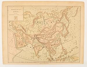
Physical map of Asia
Verlag: Harper & Brothers., [New York.], 1875
Anbieter: Asia Bookroom ANZAAB/ILAB, Canberra, ACT, Australien
Verkäuferbewertung 5 von 5 Sternen

Map printed in colour, polar projection, 21 x 27.1 cm, marginal spotting and toning, small edge tears to the inner margin, but in god condition. Prepared for "Harper's School Geography" first published by Harper & Brothers in 1875. The map shows physical features, mountains, steppes, plains, rivers and deserts etc. together with sources of primary production: whale fisheries, furs, coffe, tea, minerals etc.The verso of the map with references and attractive line engravings, part of the entry for Netherlands and Belgium.
-

ASIA, PHYSICAL MAP / ASIEN PHYSISCHE KARTE, BONNEFONT / VUILLEMIN 1885 Titel: Asie Physique.; par L. Bonnefont; Gravé par Erhard; dressé par A. Vuillemin
Verlag: Lanée Editeur ca. 1885, Paris, 1885
Anbieter: ANTIQUARIAT.WIEN Fine Books & Prints, Wien, Österreich
Verkäuferbewertung 5 von 5 Sternen
Karte
original map, original Landkarte, mehrfärbig, Blatt ca. 32,5 x 42 cm ORIGINAL MAP /ORIGINALE LANDKARTE // Louis Bonnefont, Alexandre Aime? Vuillemin (1812-); Bonacker 232 de 500 Landkarte.
-
Carte Physique et Politique de l'Asie. Physical and Political Map of Asia Showing British Possessions. Mapa Fisico y Politico de Asia. Carta Fisica y Politica dell'Asia.
Erscheinungsdatum: 1888
Anbieter: Geographicus Rare Antique Maps, Brooklyn, NY, USA
Verbandsmitglied: ABAA ESA ILAB
Verkäuferbewertung 4 von 5 Sternen

Karte
Very good. Light soiling. Dissected and mounted on linen in thirty-two (32) panels. Size 28.5 x 39 Inches. This is an 1888 Jean Dosseray map of Asia, published at the height of the Great Game. Dosseray's map broadly covers all of Asia. It is titled in French, English, Spanish, and Italian, suggesting he intended it for a pan-European audience. Regions are identified by a mix of local and Western names, with tribes referenced in certain areas, suggesting a remarkable level of ethnic sensitivity for the period. Historical Context The late 19th century was a tense era for global relations between the British and the Russians in Central Asia, with both powers continually expanding their 'spheres of influence'. Britain feared Russian advances into Khiva and Bukhara (the yellow region just above Afghanistan). The rail networks in western Russia snaking toward the Caspian Sea and the British rail network expanding north from Calcutta (Kolkata) northwest into the Punjab and the border with Afghanistan reinforce this reality. The Great Game 'The Great Game' was a diplomatic confrontation between the British and Russian Empires over Afghanistan and other territories in Central and Southern Asia. The conflict, rooted in long-standing animosity between Russia and Britain, revolved around Afghanistan, which, while lacking significant resources of its own, was strategically situated. For its part, Russia feared Britain was making commercial and military inroads into Central Asia, an area long within the sphere of influence of St. Petersburg. Britain, conversely, feared Russia making gains in India, 'the jewel in the crown' of British Asia. The escalating tensions led to several wars and proxy wars: The First Anglo-Afghan War (1839 - 1842), the First Anglo-Sikh War (1845 - 1846), the Second Anglo-Sikh War (1848 - 1849), and the Second Anglo-Afghan War (1878 - 1880), along with the Russian annexations of Khiva, Bukhara, and Kokand. Then as now, Afghanistan proved a grinding stone upon which the world's great empires diminished themselves, none achieving a definitive victory despite committing staggering resources. The Great Game 'ended' on September 10, 1895, with the signing of the Pamir Boundary Commission Protocols, which stabilized the border between Afghanistan and the Russian Empire - but well into the 20th century the British were well aware the conflict remained. Regarding the attitude of Afghans to the British and to the Russians, the general assumption of the British was that 'Some will fight for us, some against us, but all will fight.' Publication History and Census This map was created and published by Jean Dosseray in 1888. This is the only known cataloged example.
-
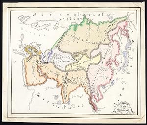
Unique Manuscript Map-ASIA-PHYSICAL-CHINA-ARABAIA-INDIA-Dumont-1865
Anbieter: ThePrintsCollector, Zeeland, Niederlande
Verkäuferbewertung 5 von 5 Sternen
Kunst / Grafik / Poster
Antique manuscript map, titled: 'Asie physique' - A physical map of Asie with China, Japan, India, Arabia and Russia. Indicating mountain ranges and plateaus/highland. Pen and ink drawing, handcoloured, on vellin paper. Description: Source unknown, to be determined. Unique manuscript map. Artists and Engravers: Made by 'Valentine Dumont' after own design. This map possibly by Valentine Francoise Dumont (Gent; 1848-1928) a Flemish / Belgian artist, painter of animals (particular donkeys and fowls), sister of Marguerite Dumont. Condition: Good, given age. Remains of attachment to carrier to the corners of the front of the sheet. General age-related toning and/or occasional minor defects from handling. Please study scan carefully. Storage location: TPCRC-C2-27 The overall size is ca. 9 x 8.3 inch. The image size is ca. 8.3 x 7.2 inch. The overall size is ca. 22.8 x 21 cm. The image size is ca. 21 x 18.3 cm.
