Gesamtpreis (1 Artikel Artikel):
Versandziel:

ordnance survey map large sheet (27 Ergebnisse)
Direkt zu den wichtigsten Suchergebnissen
Suchfilter
Produktart
- Alle Product Types
- Bücher (23)
- Magazine & Zeitschriften (Keine weiteren Ergebnisse entsprechen dieser Verfeinerung)
- Comics (Keine weiteren Ergebnisse entsprechen dieser Verfeinerung)
- Noten (Keine weiteren Ergebnisse entsprechen dieser Verfeinerung)
- Kunst, Grafik & Poster (1)
- Fotografien (Keine weiteren Ergebnisse entsprechen dieser Verfeinerung)
- Karten (3)
- Manuskripte & Papierantiquitäten (Keine weiteren Ergebnisse entsprechen dieser Verfeinerung)
Zustand Mehr dazu
- Neu (Keine weiteren Ergebnisse entsprechen dieser Verfeinerung)
- Wie Neu, Sehr Gut oder Gut Bis Sehr Gut (Keine weiteren Ergebnisse entsprechen dieser Verfeinerung)
- Gut oder Befriedigend (7)
- Ausreichend oder Schlecht (Keine weiteren Ergebnisse entsprechen dieser Verfeinerung)
- Wie beschrieben (20)
Einband
Weitere Eigenschaften
- Erstausgabe (2)
- Signiert (Keine weiteren Ergebnisse entsprechen dieser Verfeinerung)
- Schutzumschlag (1)
- Angebotsfoto (16)
Sprache (2)
Gratisversand
- Kostenloser Versand nach USA (Keine weiteren Ergebnisse entsprechen dieser Verfeinerung)
Land des Verkäufers
Verkäuferbewertung
-

Ordnance Survey Map England and Wales. Large Series Sheet 125 . Scale : 1 inch to a mile Guildford and Horsham
Verlag: Ordnance Survey Office / Edward Stanford, 1914
Anbieter: Gwyn Tudur Davies, Aberystwyth, Vereinigtes Königreich
Verkäuferbewertung 5 von 5 Sternen

Karte
EUR 11,91
EUR 14,46 Versand
Versand von Vereinigtes Königreich nach USAAnzahl: 1 verfügbar
In den WarenkorbSoft cover. Zustand: Good. Zustand des Schutzumschlags: Good. 3rd Edition. 1 folded folded cloth map. Some annotations and small stain on on covers o/w the map itself is clean unmarked and in very good condition. Railways revised in 1914. e1030 / m11766.
-
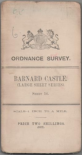
Ordnance Survey Map of England & Wales. Sheet 14. Barnard Castle. Large Sheet Series
Verlag: Ordnance Survey, Southampton, 1907
Anbieter: Anvil Books, Prestatyn, FLINT, Vereinigtes Königreich
Verkäuferbewertung 5 von 5 Sternen
Karte
EUR 14,30
EUR 27,76 Versand
Versand von Vereinigtes Königreich nach USAAnzahl: 1 verfügbar
In den WarenkorbMap. Zustand: Good. No Jacket. 3rd Edition. Revised in 1904. 1 inch to 1 mile, 28 x 20 inches, 24 panels, mounted on linen, sl wear at folds, sl foxing, inscr on front cover.
-
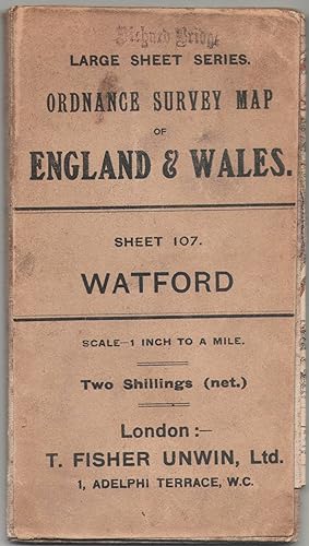
Ordnance Survey Map of England & Wales. Sheet 107. Watford. Large Sheet Series
Verlag: Ordnance Survey, Southampton, 1908
Anbieter: Anvil Books, Prestatyn, FLINT, Vereinigtes Königreich
Verkäuferbewertung 5 von 5 Sternen
Karte
EUR 14,30
EUR 27,76 Versand
Versand von Vereinigtes Königreich nach USAAnzahl: 1 verfügbar
In den WarenkorbMap. Zustand: Good. No Jacket. 3rd Edition. Revised in 1902, railways revised in May 1912, minor corrections Feb 1910. 1 inch to 1 mile, 30 x 20 inches, 24 panels, mounted on linen, sl wear at folds, sl foxing, stamp on front cover, inscr on rear cover.
-

LARGE Ordnance Survey MAP Sheet XXXV.14 DORSET. Knighton & Canford Magna, Bear Wood. Scale 1:2500 or 25.344 inches to 1 mile.
Verlag: ORDNANCE SURVEY 1934, 1934
Anbieter: PROCTOR / THE ANTIQUE MAP & BOOKSHOP, DORCHESTER, Vereinigtes Königreich
Verbandsmitglied: PBFA
Verkäuferbewertung 5 von 5 Sternen
EUR 23,83
EUR 23,14 Versand
Versand von Vereinigtes Königreich nach USAAnzahl: 1 verfügbar
In den WarenkorbOriginal Folded flat map. Approximate size is 100cm x 74cm. Shows areas of Knighton & Canford Magna, Bear Wood In good condition. Some light rubbing on edges, with a few small creases lightly tanned. With vertical and horizontal folds. County Borders Changed in 1974 From Hampshire to Dorset It will be rolled up and posted in a poster tube.
-
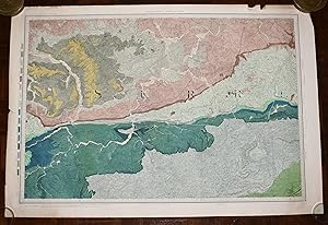
Large Hand Coloured Geological Ordnance Survey MAP SHEET 12 Basingstoke Hampshire Geological Survey of England & Wales Scale 1 inch to 1 mile.
Verlag: Geological Survey of England & Wales Colonel Colby 1860 Revised 1885, 1885
Anbieter: PROCTOR / THE ANTIQUE MAP & BOOKSHOP, DORCHESTER, Vereinigtes Königreich
Verbandsmitglied: PBFA
Verkäuferbewertung 5 von 5 Sternen
EUR 23,83
EUR 23,14 Versand
Versand von Vereinigtes Königreich nach USAAnzahl: 1 verfügbar
In den WarenkorbOriginal rolled flat map. Hand-coloured engraving With ORDNANCE SURVEY Blind Stamp top margin. Size 33.5 inches X 26.5 inches. 84cm x 66cm Ordnance survey map showing Basingstoke, Whitchurch, Andover & surrounding areas. In good condition. Some foxing & a little dusty on margins & tear on right hand side of map. A few small nicks top edge. Unfolded. It will be rolled up and posted in a poster tube.
-

LARGE Ordnance Survey MAP Sheet XLIV.6 Trinidad Estate Branksome - Bourne Valley Poole DORSET Scale 1:2500 or 25.344 inches to 1 mile.
Verlag: ORDNANCE SURVEY 1937, 1937
Anbieter: PROCTOR / THE ANTIQUE MAP & BOOKSHOP, DORCHESTER, Vereinigtes Königreich
Verbandsmitglied: PBFA
Verkäuferbewertung 5 von 5 Sternen
EUR 23,83
EUR 23,14 Versand
Versand von Vereinigtes Königreich nach USAAnzahl: 1 verfügbar
In den WarenkorbOriginal Folded flat map. Approximate size is 100cm x 74cm. Shows areas of Newtown, Trinidad Estate Branksome - Bourne Valley Wallisdown Poole. In good condition. Some light rubbing on edges. Small pin holes in corners. Small nick top & bottom edge. A little creased on corners. With vertical and horizontal folds. It will be rolled up and posted in a poster tube.
-

Large Hand Coloured Geological Ordnance Survey MAP SHEET 47 S.W Essex Geological Survey of England & Wales Scale 1 inch to 1 mile.
Verlag: Geological Survey of England & Wales 1884, 1884
Anbieter: PROCTOR / THE ANTIQUE MAP & BOOKSHOP, DORCHESTER, Vereinigtes Königreich
Verbandsmitglied: PBFA
Verkäuferbewertung 5 von 5 Sternen
EUR 26,21
EUR 23,14 Versand
Versand von Vereinigtes Königreich nach USAAnzahl: 1 verfügbar
In den WarenkorbOriginal rolled flat map. Hand-coloured engraving With ORDNANCE SURVEY Blind Stamp top margin. Size 40 inches X 26.5 inches. 100cm x 68cm Ordnance survey map showing Saffron Walden, Whitham, Royston & surrounding areas. In generally good condition. Some foxing & a little dusty on margins & right hand side. A few small nicks on edges, a little tatty top left corner. Unfolded. It will be rolled up and posted in a poster tube.
-

Ordnance Survey Map - Watford & High Wycombe - Large Sheet Series- Sheet 107
Verlag: Ordnance Survey Office, Southampton, 1908
Anbieter: Jacques Gander, Fairford, Vereinigtes Königreich
Verkäuferbewertung 5 von 5 Sternen
EUR 28,60
EUR 21,98 Versand
Versand von Vereinigtes Königreich nach USAAnzahl: 1 verfügbar
In den WarenkorbThird Edition. Published 1908, Railways revised to 1912. Cloth map. Sheet size is 31 X 21 inches, folding to 4 X 7 inches.Scale 1 inch to a mile. Coloured map on plain linen backing. One face of the folded map is printed in black with " 1" ENGLAND. SHEET 107" the map is generally in good condition, a little dustsoiled and there is some staining which only shows through on to the map a very little, and with the sheet number "107" written in ink in the corner.
-
Ordnance Survey Map - Reading & Newbury - Large Sheet Series- Sheet 114
Verlag: Ordnance Survey Office, Southampton, 1909
Anbieter: Jacques Gander, Fairford, Vereinigtes Königreich
Verkäuferbewertung 5 von 5 Sternen
EUR 28,60
EUR 21,98 Versand
Versand von Vereinigtes Königreich nach USAAnzahl: 1 verfügbar
In den WarenkorbThird Edition. Published 1909, Railways revised to 1912. Cloth map. Sheet size is 31 X 21 inches, folding to 4 X 7 inches.Scale 1 inch to a mile. Coloured map on plain linen backing. One face of the folded map is printed in black with " 1" ENGLAND. SHEET 114" the map is generally in good condition, a little dustsoiled and there is some staining which shows through on to the map here and there. There are some pencil notes in the margin and with the sheet number "114" written in ink in the corner.
-
Ordnance Survey Map - Boston - Large Sheet Series- Sheet 56
Verlag: Ordnance Survey Office, Southampton
Anbieter: Jacques Gander, Fairford, Vereinigtes Königreich
Verkäuferbewertung 5 von 5 Sternen
EUR 28,60
EUR 21,98 Versand
Versand von Vereinigtes Königreich nach USAAnzahl: 1 verfügbar
In den WarenkorbThird Edition. Published 1910, Railways revised to 1912. Cloth map. Sheet size is 31 X 21 inches, folding to 4 X 7 inches.Scale 1 inch to a mile. Coloured map on plain linen backing. One face of the folded map is printed in black with the Crown crest, the map details and a small sketch map showing the area covered. the map is in very good condition, a little dustsoiled and with the sheet number "65" written in ink in the corner.
-
Ordnance Survey Map - N.E. London & Epping Forest - Large Sheet Series- Sheet 108
Verlag: Ordnance Survey Office, Southampton, 1908
Anbieter: Jacques Gander, Fairford, Vereinigtes Königreich
Verkäuferbewertung 5 von 5 Sternen
EUR 28,60
EUR 21,98 Versand
Versand von Vereinigtes Königreich nach USAAnzahl: 1 verfügbar
In den WarenkorbThird Edition. Published 1908, Cloth map. Sheet size is 31 X 21 inches, folding to 4 X 7 inches.Scale 1 inch to a mile. Coloured map on plain linen backing. One face of the folded map is printed in black with the Crown crest, the map details and a small sketch map showing the area covered. the map is in very good condition, a little dustsoiled and with the sheet number "108" written in ink in the corner.
-
Ordnance Survey Map - Grantham - Large Sheet Series- Sheet 55
Verlag: Ordnance Survey Office, Southampton, 1908
Anbieter: Jacques Gander, Fairford, Vereinigtes Königreich
Verkäuferbewertung 5 von 5 Sternen
EUR 28,60
EUR 21,98 Versand
Versand von Vereinigtes Königreich nach USAAnzahl: 1 verfügbar
In den WarenkorbThird Edition. Published 1908, Railways revised to 1912. Cloth map. Sheet size is 31 X 21 inches, folding to 4 X 7 inches.Scale 1 inch to a mile.Coloured map on plain linen backing. One face of the folded map is printed in black with the Crown crest, the map details and a small sketch map showing the area covered. the map is in very good condition, a little dustsoiled with spotting on the outer faces of the folded map, and with the sheet number "55" written in ink in the corner.
-
Ordnance Survey Map - Winchester & Alton - Large Sheet Series- Sheet 124
Verlag: Ordnance Survey Office, Southampton, 1909
Anbieter: Jacques Gander, Fairford, Vereinigtes Königreich
Verkäuferbewertung 5 von 5 Sternen
EUR 28,60
EUR 21,98 Versand
Versand von Vereinigtes Königreich nach USAAnzahl: 1 verfügbar
In den WarenkorbThird Edition. Published 1909, Railways revised to 1912. Cloth map. Sheet size is 31 X 21 inches, folding to 4 X 7 inches.Scale 1 inch to a mile. Coloured map on plain linen backing. One face of the folded map is printed in black with " 1" ENGLAND. SHEET 124" the map is in very good condition, a little dustsoiled and a little stained and with the sheet number "124" written in ink in the corner. Also a few pencil notes in the margin.
-
Ordnance Survey Map - Cambridge - Large Sheet Series- Sheet 85
Verlag: Ordnance Survey Office, Southampton
Anbieter: Jacques Gander, Fairford, Vereinigtes Königreich
Verkäuferbewertung 5 von 5 Sternen
EUR 28,60
EUR 21,98 Versand
Versand von Vereinigtes Königreich nach USAAnzahl: 1 verfügbar
In den WarenkorbThird Edition. Published 1908. Cloth map. Sheet size is 31 X 21 inches, folding to 4 X 7 inches.Scale 1 inch to a mile. Coloured map on plain linen backing. One face of the folded map is printed in black with the Crown crest, the map details and a small sketch map showing the area covered. the map is in very good condition, with foxing to the outer faces of the folded map and a little dustsoiled and with the sheet number "85" written in ink in the corner.
-
Ordnance Survey Map - Peterborough and Wisbech - Large Sheet Series- Sheet 65
Verlag: Ordnance Survey Office, Southampton
Anbieter: Jacques Gander, Fairford, Vereinigtes Königreich
Verkäuferbewertung 5 von 5 Sternen
EUR 28,60
EUR 21,98 Versand
Versand von Vereinigtes Königreich nach USAAnzahl: 1 verfügbar
In den WarenkorbThird Edition. Published 1910, Railways revised to 1912. Cloth map. Sheet size is 31 X 21 inches, folding to 4 X 7 inches.Scale 1 inch to a mile. Coloured map on plain linen backing. One face of the folded map is printed in black with the Crown crest, the map details and a small sketch map showing the area covered. the map is in very good condition, a little dustsoiled and with the sheet number "65" written in ink in the corner.
-
Ordnance Survey Map - Tunbridge Wells & Redhill - Large Sheet Series- Sheet 126
Verlag: Ordnance Survey Office, Southampton
Anbieter: Jacques Gander, Fairford, Vereinigtes Königreich
Verkäuferbewertung 5 von 5 Sternen
EUR 28,60
EUR 21,98 Versand
Versand von Vereinigtes Königreich nach USAAnzahl: 1 verfügbar
In den WarenkorbThird Edition. Published 1909, Railways revised to 1914. Cloth map. Sheet size is 31 X 21 inches, folding to 4 X 7 inches.Scale 1 inch to a mile. Coloured map on plain linen backing. One face of the folded map is printed in black with the Crown crest, the map details and a small sketch map showing the area covered. the map is in very good condition, a little dustsoiled and with the sheet number "126" written in ink in the corner.
-
Ordnance Survey Map - South-West London, Surrey & Bucks - Large Sheet Series- Sheet 115
Verlag: Ordnance Survey Office, Southampton
Anbieter: Jacques Gander, Fairford, Vereinigtes Königreich
Verkäuferbewertung 5 von 5 Sternen
EUR 28,60
EUR 21,98 Versand
Versand von Vereinigtes Königreich nach USAAnzahl: 1 verfügbar
In den WarenkorbThird Edition. Published 1909, Railways revised to 1911. Cloth map. Sheet size is 31 X 21 inches, folding to 4 X 7 inches.Scale 1 inch to a mile. Coloured map on plain linen backing. One face of the folded map is printed in black with the Crown crest, the map details and a small sketch map showing the area covered. the map is in very good condition, with foxing to the outer faces of the folded map and a little dustsoiled and with the sheet number "115" written in ink in the corner.
-
![Bild des Verkäufers für Ordnance Survey [Large Sheet Series] Map of Winchester & Alton: Sheet 124 zum Verkauf von Little Stour Books PBFA Member](https://pictures.abebooks.com/inventory/md/md4026300670.jpg)
Ordnance Survey [Large Sheet Series] Map of Winchester & Alton: Sheet 124
Verlag: Published Printed at the Ordnance Survey Office Southampton . 1909., 1909
Anbieter: Little Stour Books PBFA Member, Canterbury, Vereinigtes Königreich
Verbandsmitglied: PBFA
Verkäuferbewertung 5 von 5 Sternen
EUR 20,86
EUR 34,70 Versand
Versand von Vereinigtes Königreich nach USAAnzahl: 1 verfügbar
In den WarenkorbOriginal cloth backed folded 21 section colour dissected map opening to 28'' x 21'' and folding to 7'' x 4''. One Inch to One Mile. Small holes to the the corner points of the folds, a little brown staining to the rear of the cloth. Member of the P.B.F.A. HAMPSHIRE (Hantescire).
-
Large Hand Coloured Geological Ordnance Survey MAP SHEET 8 Guildford SURREY Geological Survey of England & Wales Scale 1 inch to 1 mile.
Verlag: Geological Survey of England & Wales Colonel Colby 1816 Revised 1891, 1891
Anbieter: PROCTOR / THE ANTIQUE MAP & BOOKSHOP, DORCHESTER, Vereinigtes Königreich
Verbandsmitglied: PBFA
Verkäuferbewertung 5 von 5 Sternen
EUR 33,36
EUR 23,14 Versand
Versand von Vereinigtes Königreich nach USAAnzahl: 1 verfügbar
In den WarenkorbOriginal rolled flat map. Hand-coloured engraving With ORDNANCE SURVEY Blind Stamp top margin. Size 33.5 inches X 26 inches. 85cm x 66cm Ordnance survey map showing Guildford & surrounding areas. In good condition. Some foxing & a little dusty on margins. Margin has small tear on left, crease down right hand margin, Top edge a little nicked with one tear. MAP not affected by edge nicks etc. Unfolded. It will be rolled up and posted in a poster tube.
-
![Bild des Verkäufers für The Ordnance Survey One-Inch Map of England and Wales [Third Edition] Large Sheet Series; A Descriptive and Cartobibliographical Monograph zum Verkauf von Little Stour Books PBFA Member](https://pictures.abebooks.com/inventory/md/md1216544835.jpg)
The Ordnance Survey One-Inch Map of England and Wales [Third Edition] Large Sheet Series; A Descriptive and Cartobibliographical Monograph
Verlag: Published by The Charles Close Society for the Study of Ordnance Survey Maps Third Edition . 1988., 1988
Anbieter: Little Stour Books PBFA Member, Canterbury, Vereinigtes Königreich
Verbandsmitglied: PBFA
Verkäuferbewertung 5 von 5 Sternen
Erstausgabe
EUR 23,24
EUR 34,70 Versand
Versand von Vereinigtes Königreich nach USAAnzahl: 1 verfügbar
In den WarenkorbZustand: Very Good. First edition in publisher's original illustrated card wrap covers. 8vo. 8˝'' x 5Ľ''. ISBN 1870598032. Contains [iv] 252 printed pages of text with monochrome illustrations throughout. Spine slightly sun faded, without any ownership markings and in Very Good condition, no dust wrapper as published. Member of the P.B.F.A. GEOGRAPHY (Human, Physical).
-
Ordnance Survey Map Poole Harbour (Large Sheet Series Sheet 144)
Sprache: Englisch
Verlag: London
Anbieter: Richard Thornton Books PBFA, Clitheroe, LANCA, Vereinigtes Königreich
Verbandsmitglied: PBFA
Verkäuferbewertung 4 von 5 Sternen

Erstausgabe
EUR 89,36
EUR 18,45 Versand
Versand von Vereinigtes Königreich nach USAAnzahl: 1 verfügbar
In den WarenkorbCloth. Zustand: Very Good+. No Jacket. First Edition. This is a Very Good+ Copy of this map scale of 1 inch to 1 mile,linen backed lettered in black large coloured folding map in excellent order priced at two shillings net.Rare with folding frames of map in very good order.
-

Large Hand Coloured Geological Ordnance Survey MAP SHEET 12 Basingstoke Hampshire Geological Survey of England & Wales Scale 1 inch to 1 mile.
Verlag: Geological Survey of England & Wales Colonel Colby 1860 Revised 1885, 1885
Anbieter: PROCTOR / THE ANTIQUE MAP & BOOKSHOP, DORCHESTER, Vereinigtes Königreich
Verbandsmitglied: PBFA
Verkäuferbewertung 5 von 5 Sternen
EUR 39,32
EUR 23,14 Versand
Versand von Vereinigtes Königreich nach USAAnzahl: 1 verfügbar
In den WarenkorbOriginal rolled flat map. Hand-coloured engraving With ORDNANCE SURVEY Blind Stamp top margin. Size 32.5 inches X 27.5 inches. 82cm x 70cm Ordnance survey map showing Basingstoke, Whitchurch, Andover & surrounding areas. In good condition. Some foxing & a little dusty on margins & slightly on right hand side of map. A few small nicks lower edge. Unfolded. It will be rolled up and posted in a poster tube.
-
HARDENDALE FELL; WESTMORLAND SHEET XIV. 14. - Very Large Ordnance Survey Map 1898; Scale 1:2500
Verlag: Ordnance Survey, Southampton, 1898
Anbieter: LOE BOOKS, Bathpool, CORNW, Vereinigtes Königreich
Verkäuferbewertung 4 von 5 Sternen
Kunst / Grafik / Poster
EUR 35,74
EUR 23,71 Versand
Versand von Vereinigtes Königreich nach USAAnzahl: 1 verfügbar
In den WarenkorbUnframed. Zustand: Very Good. Second Edition. A very large original map measuring 104 x 136cm, 64 sections dissected onto a linen backing; folding into original brown covers, the upper with a label of Edward Stanford, Ltd, London. A very good copy in very good condition. Map/Print.
-

Large Hand Coloured Geological Ordnance Survey MAP SHEET 7 LONDON including River Thames Middlesex Geological Survey of England & Wales Scale 1 inch to 1 mile.
Verlag: Geological Survey of England & Wales Colonel Colby 1822 Revised 1885, 1885
Anbieter: PROCTOR / THE ANTIQUE MAP & BOOKSHOP, DORCHESTER, Vereinigtes Königreich
Verbandsmitglied: PBFA
Verkäuferbewertung 5 von 5 Sternen
EUR 65,53
EUR 23,14 Versand
Versand von Vereinigtes Königreich nach USAAnzahl: 1 verfügbar
In den WarenkorbOriginal rolled flat map. Hand-coloured engraving With ORDNANCE SURVEY Blind Stamp top margin. Size 39.5 inches X 27 inches. 100cm x 69cm Ordnance survey map showing Uxbridge, Windsor, Watford Chelsea & surrounding areas. In generally good condition. Some foxing & a little dusty on margins & 2 tears together on top edge of map. A few small nicks on edges. Unfolded. It will be rolled up and posted in a poster tube.
-

LARGE Ordnance Survey MAP Sheet LI. 5 DORSET. Brownsea Island (Ferry Side) Sandbanks Scale 1:2500 or 25.344 inches to 1 mile.
Verlag: ORDNANCE SURVEY 1933, 1933
Anbieter: PROCTOR / THE ANTIQUE MAP & BOOKSHOP, DORCHESTER, Vereinigtes Königreich
Verbandsmitglied: PBFA
Verkäuferbewertung 5 von 5 Sternen
EUR 65,53
EUR 23,14 Versand
Versand von Vereinigtes Königreich nach USAAnzahl: 1 verfügbar
In den WarenkorbOriginal Folded flat map. Approximate size is 100cm x 74cm. Shows areas of Brownsea Island (Ferry Side) Sandbanks, Studland Heath, Poole Bay. In good condition. Some light rubbing on edges, with a few small corner creases & lightly tanned. With a few vertical and horizontal folds. It will be rolled up and posted in a poster tube.
-

Ordnance Survey Map Large Sheet Series | Sheet XIX North East | Banstead Urban District Council | 6 Inches to 1 Mile
Verlag: Published by Ordnance Survey, Southampton . 1915., 1915
Anbieter: Little Stour Books PBFA Member, Canterbury, Vereinigtes Königreich
Verbandsmitglied: PBFA
Verkäuferbewertung 5 von 5 Sternen
EUR 274,04
EUR 34,70 Versand
Versand von Vereinigtes Königreich nach USAAnzahl: 1 verfügbar
In den WarenkorbZustand: Very Good. Hard back folding 16 section black and white map with blue boundary line dissected on linen measuring 52'' x 39'' in dark brown hard back boards folding down to 13'' x 10'' when closed. Scale 6 inches to one statute mile. In Very Good clean and bright condition. Fantastic centre piece for framing. Member of the P.B.F.A. SURREY (Suthrige).
-
VERY LARGE Geological Survey Map, Torbay to Weymouth Ordnance Survey of England and Wales - Geological Survey of Great Britain - Sheet No. XVIII.
Verlag: Lt. Col. Mudge, Tower, Ordnance Survey 1855, 1855
Anbieter: PROCTOR / THE ANTIQUE MAP & BOOKSHOP, DORCHESTER, Vereinigtes Königreich
Verbandsmitglied: PBFA
Verkäuferbewertung 5 von 5 Sternen
EUR 524,24
EUR 23,14 Versand
Versand von Vereinigtes Königreich nach USAAnzahl: 1 verfügbar
In den WarenkorbLarge folding map, 68 x 49.5 inches. 36 cut sections mounted on linen, folded size approx 12.5 x 8 inches. Bound in grey cloth with dark green endpapers. Handwritten paper title label to spine. In very good condition. A couple of minor handling marks else map clean and bright, nice bright neat colouring. Fading to cloth binding, some handling marks to boards. Hand coloured. Engraved at the Drawing Room in the Tower by Benj. Baker & Assistants. The Writing by Ebenr. Bourne.Geological information published 1850-55 by Sir Henry de la Beche, Director General of The Geological Survey.