
Gesamtpreis (1 Artikel Artikel):
Versandziel:

oldenburg comitatus (11 Ergebnisse)
Direkt zu den wichtigsten Suchergebnissen
Suchfilter
Produktart
- Alle Product Types
- Bücher (3)
- Magazine & Zeitschriften (Keine weiteren Ergebnisse entsprechen dieser Verfeinerung)
- Comics (Keine weiteren Ergebnisse entsprechen dieser Verfeinerung)
- Noten (Keine weiteren Ergebnisse entsprechen dieser Verfeinerung)
- Kunst, Grafik & Poster (2)
- Fotografien (Keine weiteren Ergebnisse entsprechen dieser Verfeinerung)
- Karten (6)
- Manuskripte & Papierantiquitäten (Keine weiteren Ergebnisse entsprechen dieser Verfeinerung)
Zustand Mehr dazu
- Neu (Keine weiteren Ergebnisse entsprechen dieser Verfeinerung)
- Wie Neu, Sehr Gut oder Gut Bis Sehr Gut (2)
- Gut oder Befriedigend (4)
- Ausreichend oder Schlecht (Keine weiteren Ergebnisse entsprechen dieser Verfeinerung)
- Wie beschrieben (5)
Einband
- alle Einbände
- Hardcover (Keine weiteren Ergebnisse entsprechen dieser Verfeinerung)
- Softcover (Keine weiteren Ergebnisse entsprechen dieser Verfeinerung)
Weitere Eigenschaften
- Erstausgabe (Keine weiteren Ergebnisse entsprechen dieser Verfeinerung)
- Signiert (Keine weiteren Ergebnisse entsprechen dieser Verfeinerung)
- Schutzumschlag (Keine weiteren Ergebnisse entsprechen dieser Verfeinerung)
- Angebotsfoto (11)
Sprache (2)
Preis
- Beliebiger Preis
- Weniger als EUR 20 (Keine weiteren Ergebnisse entsprechen dieser Verfeinerung)
- EUR 20 bis EUR 40 (Keine weiteren Ergebnisse entsprechen dieser Verfeinerung)
- Mehr als EUR 40
Gratisversand
- Kostenloser Versand nach USA (Keine weiteren Ergebnisse entsprechen dieser Verfeinerung)
Land des Verkäufers
Verkäuferbewertung
-

Oldenburg Comitatus
Verlag: Janssonius, Amsterdam, 1630
Anbieter: Antikvariat Krenek, Prag, Tschechien
Verbandsmitglied: ILAB
Verkäuferbewertung 5 von 5 Sternen

Karte
Kein Einband. Zustand: Sehr gut. Oldenburg. "Oldenburg Comitatus". Altkol. Kupferstich Karte bei J. Janssonius, Amsterdam, 1630. Mit ausgem ornament. Titelkart. mit einem Wappen, ornament. Kart. mit Meilenanzeiger und eine Windrose. 38:49 cm. Koeman I, map 2320:1.1, ed. 1:321/22 (1633 German). - Westorientierte Karte von Jadebusen und Wesermündung mit dem Kreis Oldenburg und den Städten Bremen, Delmenhorst, Wildeshausen, Oldenburg, Jever u.a.
-
Oldenburg Comitatus
Verlag: Amsterdam
Anbieter: Argosy Book Store, ABAA, ILAB, New York, NY, USA
Verkäuferbewertung 5 von 5 Sternen
unbound. Map. Copperplate engraving with original hand coloring. Image measures 14.5 x 19". This decorative map of Oldenburg and Bremen in Germany includes Jadebusen and the estuary of the Weser. Oriented with north to the right, it depicts towns, fortresses, and beautifully rendered topography. Map is in good condition with some edge wear and overall toning. Minor wear along original centerfold. Brittle paper. Petrus Schenk (c.1660--1711) was a German engraver and cartographer. He began his training in Amsterdam in the art of mezzotint and soon began working closely with Gerard Valck. The two took advantage of the bustling cartographic trade in the city and quickly expanded their business from portraits and prints into maps and globes. In 1700, Schenk grew the business further by moving to Leipzig, Germany and opening a shop. As his sons and grandson returned to the Netherlands to become active engravers as well, the Schenk firm developed into one of the best-known publishing houses in 18th-century Amsterdam. This map attests to Schenk's prolific production and skill in both cartographic artistry and business.
-
Oldenburg, comitatus, anno 1603, Ortelius, old colours
Verlag: Ortelius Abraham, 1527-1598, 1603
Anbieter: Hammelburger Antiquariat, Hammelburg, Deutschland
Verkäuferbewertung 5 von 5 Sternen
Karte
Kein Einband. Zustand: Gut. Kupferstich, verlegt von Ortelius Abraham, in Theatrum Orbis Terrarum, anno 1603, lat. Ausgabe, altkolorert, "Oldenburg", Plattenmaß: 342x241 mm., altes, leuchtendes Kolorit, an den Rändern etwas fleckig und rissig, die Karte in sehr gutem Erhaltungszustand. Referenz: vdB Nr. 90B.
-
Oldenburg Comitatus, anno 1647, Janssonius J., franz. Ausgabe. K
Verlag: Janssonius Jan,1588-1664, 1664
Anbieter: Hammelburger Antiquariat, Hammelburg, Deutschland
Verkäuferbewertung 5 von 5 Sternen
Karte
Kein Einband. Zustand: Gut. Oldenburg Comitatus, anno 1647, Janssonius J., franz. Ausgabe. Kupferkarte, verlegt bei Janssonius, anno 1647, franz. Rückentext, guter Erhaltungszustand, breitrandig, gedruckt auf dickem Papier, bis auf einige wenige Wurmlöchlein an der Mittelfalz sehr gut erhalten. Blattmaß: 50x60 cm. Zeigt die Wesermündung, Jadebusen, Jever, Oldenburg, Bremen, Delmenhorst usw.
-

Oldenburg Comitatus
Verlag: Artist: Blaeu Willem Janszoon ( - 1638 ) Amsterdam; issued in: Amsterdam; ca: 1610, 1571
Anbieter: Antique Sommer& Sapunaru KG, München, Deutschland
Verkäuferbewertung 5 von 5 Sternen
Technic: Copper print, colorit: original colored, condition: Some restoration at centerfold, size (in cm): 37,5 x 49, Map shows partly Niedersachsen with the area of Oldenburg.
-
OLDENBURG. - Karte. - Oldenburg comitatus Altkol. Kupferstich nach Hamervelt von Blaeu, um 1630
Sprache: Deutsch
Verlag: ohne Verlagsangabe um 1740., 1740
Anbieter: Antiquariat Buchseite, Purkersdorf, Österreich
Verkäuferbewertung 5 von 5 Sternen
Kunst / Grafik / Poster
SonderangebotEUR 151,50
EUR 72,50 Versand
Versand von Österreich nach USAAnzahl: 1 verfügbar
In den WarenkorbKartenmaße 53,5 x 42,5 cm. Zustand: Gut. Auflage ohne Angabe. 1 Blatt Kupferstich guter Zustand, siehe Foto.Lieferung erfolgt in Kartenrollen. Sprache: Deutsch Gewicht in Gramm: 1100.
-
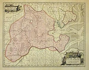
Oldenburg Comitatus [County of Oldenburg]
Erscheinungsdatum: 1645
Anbieter: Antiqua Print Gallery, London, Vereinigtes Königreich
Verkäuferbewertung 4 von 5 Sternen

Karte
EUR 249,43
EUR 11,53 Versand
Versand von Vereinigtes Königreich nach USAAnzahl: 1 verfügbar
In den WarenkorbZustand: Good. Oldenburg Comitatus. County of Oldenburg by Blaeu. Lower Saxony 1645 map. Original large folio 17th century hand coloured antique map with wide margins; Joan/Johannes Blaeu (1645). 43.5 x 56.0cm, 17 x 22 inches; this is a folding map. Condition: Good. Please contact us if you would like to arrange to view this map. There is French text printed on the reverse side.
-
Oldenburg Comitatus. Orig.-Kupferstichkarte bei Janssonius.
Sprache: Deutsch
Verlag: Amsterdam: Janssonius,, 1640
Anbieter: Antiquariat Hecht, Leer, NDS, Deutschland
Verbandsmitglied: GIAQ
Verkäuferbewertung 5 von 5 Sternen
Karte
ca. 37,5 x 49 cm, Zustand: Sehr gut. Die gewestete Karte zeigt Jadebusen (mit Windrose) und Wesermündung mit dem Kreis Oldenburg und den Städten Bremen, Delmenhorst, Wildeshausen, Oldenburg, Jever u.a. Entspricht vom Kartenbild her der Karte nach Hamersveldt bei W. Blaeu. Rechts unten Titelkartusche, links oben Meilenzeigerkartusche, links unten Druckvermerk "Amstelodami Ex Officina Ioannis Janßoni". Niederländischer Rückentext. // Zustand: Wenige Braunflecken, kräftig ausgeprägte Mittelfalz. Unter Passepartout. /laden Sprache: Deutsch Gewicht in Gramm: 5100.
-
Oldenburg Comitatus. Altkolor. Kupferstich von W. Blaeu, Amsterdam, 1635. 37,8 x 49,5 cm.
Sprache: Deutsch
Erscheinungsdatum: 1635
Anbieter: Antiquariat Daniel Schramm e.K., Kiel, Deutschland
Verkäuferbewertung 5 von 5 Sternen
Zustand: 0. Die gewestete Karte zeigt den Jadebusen und Wesermündung mit dem Kreis Oldenburg und den Städten Bremen, Delmenhorst, Wildehusen, Oldenburg, Jever u.a.- Mit Windrose, Meilenzeiger- und Titelkartusche.- Angerändert; Blattrand an linker unterer Ecke mit Abriss (unter Passepartout nicht zu sehen).- Lower Saxony - Oldenburg Comitatus. Old col. Copper engraving by W. Blaeu, Amsterdam, 1635. 37.8 x 49.5 cm. 'The vestured map shows the Jade Bay and Weser estuary with the district of Oldenburg and the towns of Bremen, Delmenhorst, Wildehusen, Oldenburg, Jever, etc.- With compass rose, mileage scale and title cartouche.- Altered; lower left corner of sheet with tear (not visible under passepartout).' Sprache: Deutsch Gewicht in Gramm: 500.
-

Kst.- Karte, b. J. Janssonius, "Oldenburg comitatus.".
Sprache: Deutsch
Anbieter: Antiquariat Clemens Paulusch GmbH, Berlin, Deutschland
Verkäuferbewertung 4 von 5 Sternen
Karte
mit altem Grenzkolorit, 1638, 37,5 x 48,7 Koeman's Atlantes Neerlandici, 2320:1.1 - Westorientierte Karte mit zwei Kartuschen und Windrose.
-

OLDENBURG. - Karte. "Oldenburg comitatus".
Anbieter: Peter Bierl Buch- & Kunstantiquariat Inh.: Andrea Bierl, Eurasburg, Deutschland
Verkäuferbewertung 4 von 5 Sternen
Kunst / Grafik / Poster
Altkol. Kupferstich nach Hamervelt von Blaeu, um 1630, 37,5 x 49 cm. Schöne Karte der Grafschaft Oldenburg mit dem Jadebusen und der Wesermündung. - Rechts unten Titelkartusche, links oben Maßstab. Tadellos erhalten.


![Bild des Verkäufers für Oldenburg Comitatus [County of Oldenburg] zum Verkauf von Antiqua Print Gallery](https://pictures.abebooks.com/inventory/md/md31683069609.jpg)

