
New map present germany shewing (3 Ergebnisse)

Verlag: Artist: Wells Edward ( - 1727 ) London ca : 1660 1667
Anbieter: Antique Sommer& Sapunaru KG, München, DeutschlandAntique Sommer& Sapunaru KG
Verkäufer/-in kontaktierenVerkäufer/-in mit 3 SternenZustand: Gebraucht
EUR 410,00
EUR 45,00 VersandVersand von Deutschland nach USAAnzahl: 1 verfügbar
In den WarenkorbTechnic: Copper print, colorit: original colored, condition: Perfect condition, size (in cm): 37 x 49 cm, Map shows the whole of Germany, Austria, the Czech Republic and partly Poland. There is also a title cartouche with a coat of arms, a compass rose and a mileage indicator cartouche.

- Karte
Anbieter: Geographicus Rare Antique Maps, Brooklyn, USAGeographicus Rare Antique Maps
Verkäufer/-in kontaktierenVerkäufer/-in mit 4 SternenZustand: Gebraucht
EUR 347,53
EUR 14,63 VersandVersand innerhalb von USAAnzahl: 1 verfügbar
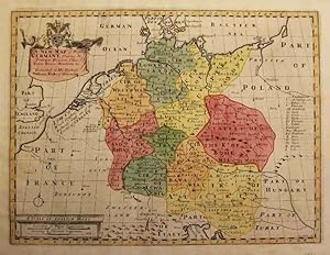
In den WarenkorbVery good. Some wear and toning along original centerfold. Damage to centerfold, repaired. Original platemark visible. Professionally flattened and backed with archival tissue. Minor foxing. Size 15 x 19.5 Inches. This is a beautiful 1712 map of Germany by Edward Wells of Oxford. It covers the entirety of the lands traditionally… occupied by the Germanic peoples, from the Gulf of Venice to the Baltic coast as from Holland to Poland. Notes towns, rivers, lakes and other topographic features. A decorative title cartouche appears in the lower right quadrant. This, like many other Wells maps, is dedicated to Prince William, Duke of Gloucester and son of Queen Anne, who, when this map was being prepared, was a student at Oxford. Engraved by R. Spofforth and published by T. Bonwicke for the 1712 edition of Edward Wells' Atlas, A New Sett of Maps both of Ancient and Present Geography . References: Rumsey 11181.016.
Sprache: Deutsch
Verlag: um 1700. 1700
- Karte
Anbieter: Kunstantiquariat Tobias Müller, Würzburg, DeutschlandKunstantiquariat Tobias Müller
Verkäufer/-in kontaktierenVerkäufer/-in mit 5 SternenZustand: Gebraucht
EUR 250,00
EUR 25,00 VersandVersand von Deutschland nach USAAnzahl: 1 verfügbar
In den WarenkorbKolor. Kupferstichkarte mit kolor. Kartusche, (engl.) Meilenzeiger und Legende von S. Nicholls nach Wells, um 1700. 36,8 x 48,8 cm. - Schwach gebräunt und minimal fleckig. - Umfasst Deutschland in seinen Grenzen von Kiel über Danzig bis an die französische und schweizerische Grenze. Im Osten sind Böhmen und Mähren und im Süden Ö…sterreich mit dem heutigen Slowenien und Kroatien erfasst. Sprache: Deutsch Gewicht in Gramm: 0.


