Gesamtpreis (1 Artikel Artikel):
Versandziel:

new geographical dictionary containing full (3 Ergebnisse)
Feedback
Direkt zu den wichtigsten Suchergebnissen
Suchfilter
Produktart
- Alle Product Types
- B³cher (3)
- Magazine & Zeitschriften (Keine weiteren Ergebnisse entsprechen dieser Verfeinerung)
- Comics (Keine weiteren Ergebnisse entsprechen dieser Verfeinerung)
- Noten (Keine weiteren Ergebnisse entsprechen dieser Verfeinerung)
- Kunst, Grafik & Poster (Keine weiteren Ergebnisse entsprechen dieser Verfeinerung)
- Fotografien (Keine weiteren Ergebnisse entsprechen dieser Verfeinerung)
- Karten (Keine weiteren Ergebnisse entsprechen dieser Verfeinerung)
- Manuskripte & Papierantiquitõten (Keine weiteren Ergebnisse entsprechen dieser Verfeinerung)
Zustand Mehr dazu
- Neu (2)
- Wie Neu, Sehr Gut oder Gut Bis Sehr Gut (Keine weiteren Ergebnisse entsprechen dieser Verfeinerung)
- Gut oder Befriedigend (1)
- Ausreichend oder Schlecht (Keine weiteren Ergebnisse entsprechen dieser Verfeinerung)
- Wie beschrieben (Keine weiteren Ergebnisse entsprechen dieser Verfeinerung)
Einband
Weitere Eigenschaften
- Erstausgabe (1)
- Signiert (Keine weiteren Ergebnisse entsprechen dieser Verfeinerung)
- Schutzumschlag (Keine weiteren Ergebnisse entsprechen dieser Verfeinerung)
- Angebotsfoto (1)
Sprache (2)
Preis
- Beliebiger Preis
- Weniger als EUR 20 (Keine weiteren Ergebnisse entsprechen dieser Verfeinerung)
- EUR 20 bis EUR 45
- Mehr als EUR 45
Gratisversand
- Kostenloser Versand nach Deutschland (Keine weiteren Ergebnisse entsprechen dieser Verfeinerung)
Land des Verkõufers
Verkõuferbewertung
-

A new and complete geographical dictionary. Containing a full and accurate description of the several parts of the known world, as divided into continents, islands, oceans, seas, rivers, lakes
Verlag: Gale Ecco, Print Editions, 2010
ISBN 10: 1171443692 ISBN 13: 9781171443698
Sprache: Englisch
Anbieter: Ria Christie Collections, Uxbridge, Vereinigtes K÷nigreich
Verkõuferbewertung 5 von 5 Sternen

EUR 32,66
Wõhrung umrechnenEUR 5,71 f³r den Versand von Vereinigtes K÷nigreich nach DeutschlandAnzahl: Mehr als 20 verf³gbar
In den WarenkorbZustand: New. In.
-

A new and Complete Geographical Dictionary. Containing a Full and Accurate Description of the Several Parts of the Known World, as Divided Into Continents, Islands, Oceans, Seas, Rivers, Lakes
Verlag: Gale Ecco, Print Editions, 2018
ISBN 10: 1385814039 ISBN 13: 9781385814031
Sprache: Englisch
Anbieter: Ria Christie Collections, Uxbridge, Vereinigtes K÷nigreich
Verkõuferbewertung 5 von 5 Sternen
EUR 42,34
Wõhrung umrechnenEUR 5,71 f³r den Versand von Vereinigtes K÷nigreich nach DeutschlandAnzahl: Mehr als 20 verf³gbar
In den WarenkorbZustand: New. In.
-
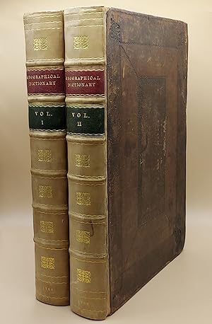
A New Geographical Dictionary. Containing a Full and Accurate Account of the Several Parts of the Known World, As it is Divided into Continents, Islands, Oceans, Seas, Rivers, Lakes, &c. The Situation, Extent, and Boundaries, of all the Empires, Kingdoms, States, Provinces, &c. in Europe, Asia, Africa, and America. Together with The Religion, Learning, Policy, Manners, and Customs, of the Inhabitants. To which is prefixed, An Introductory Dissertation, Explaining The Figure and Motion of the Earth, the Use of the Globes, and Doctrine of the Sphere, in order to render the Science of Geography easy and intelligible to the meanest Capacity (2 volumes)
Verlag: Printed for J. Coote, London, 1760
Anbieter: Ken Sanders Rare Books, ABAA, Salt Lake City, UT, USA
Verbandsmitglied: ABAA ILAB IOBA RMABA
Verkõuferbewertung 5 von 5 Sternen
Erstausgabe
EUR 2.192,16
Wõhrung umrechnenEUR 57,46 f³r den Versand von USA nach DeutschlandAnzahl: 1 verf³gbar
In den WarenkorbLeather bound. Zustand: Very Good. First edition. Folio [36.5 cm] Original dark brown decoratively embossed leather boards, rebacked with gilt-stamped calf spines in seven compartments. Red and green leather spine labels. Title pages printed in red and black. Text in double columns. Both vertical and horizontal chain lines. Restoration to the boards at corners and near head of spine. Boards rubbed and slightly mottled. Small bite to top fore-edge corner of each title page. Numerical notation in contemporary pen written twice on title page of Volume 1. A handful of the pages have minor open and closed tears. One brief manuscript notation within the text. Internally, very fresh. With a frontis, 99 plates, 37 maps, and 8 plans. An 18th century geographical dictionary, which includes a dissertation on the figure and motion of the earth, in addition to the presentation of facts about dress and customs of various lands. Quite readable and lavishly illustrated. Includes a number of maps, "with improvements" and decorative cartouches, from the "Sieur Robert's Atlas" series such as, "An Accurate Map of Africa," "An Accurate Map of North America" (The British colonies extend to the Mississippi), "The East Indies; distinguishing the Empires and Kingdoms on the Continent commonly call'd India," "A New and Accurate Map of the Kingdom of Prussia and Polish Prussia," and "An Accurate Map of the Marquisate of Moravia." Among the charmingly detailed plates included, are "A Young Lady of Aleppo smoking Tobacco, and her Servant bringing her a Dish of Coffee," "The East Entrance to the Temple of the Sun, in Palmira," "A View of Florence on the Side of the Arno, and Trinity Bridge," "Habit of an English Lady of Quality in 1588," "A Chinese Mandarin in a Summer Habit," and "Habit of a Sclavonian." John Barrow was a geographer, historian, and lexicographer. He was originally a teacher of mathematics and navigation aboard ships of the Royal Navy. He retired in 1750 and turned his attention entirely towards writing. Elizabeth Baigent writes, in her entry for the "Oxford Dictionary of National Biography," "He compiled dictionaries and other works which drew on his mathematical and scientific knowledge. Many of his works went through more than one edition and some were translated. His compilations included 'Dictionarium polygraphicum' (1735), 'Dictionarium medicum, universale' (1749), a 'Geographical Dictionary' (2 vols, 1759-60), and 'Dictionary of Arts and Sciences' (1764)." Barrow published this work, his geographical dictionary, anonymously in London. A visually pleasing work of geographical reference.