Gesamtpreis (1 Artikel Artikel):
Versandziel:

navigator containing directions navigating von cramer zadok (18 Ergebnisse)
Feedback
Direkt zu den wichtigsten Suchergebnissen
Suchfilter
Produktart
- Alle Product Types
- Bücher (18)
- Magazine & Zeitschriften (Keine weiteren Ergebnisse entsprechen dieser Verfeinerung)
- Comics (Keine weiteren Ergebnisse entsprechen dieser Verfeinerung)
- Noten (Keine weiteren Ergebnisse entsprechen dieser Verfeinerung)
- Kunst, Grafik & Poster (Keine weiteren Ergebnisse entsprechen dieser Verfeinerung)
- Fotografien (Keine weiteren Ergebnisse entsprechen dieser Verfeinerung)
- Karten (Keine weiteren Ergebnisse entsprechen dieser Verfeinerung)
- Manuskripte & Papierantiquitäten (Keine weiteren Ergebnisse entsprechen dieser Verfeinerung)
Zustand Mehr dazu
- Neu (13)
- Wie Neu, Sehr Gut oder Gut Bis Sehr Gut (2)
- Gut oder Befriedigend (2)
- Ausreichend oder Schlecht (Keine weiteren Ergebnisse entsprechen dieser Verfeinerung)
- Wie beschrieben (1)
Einband
Weitere Eigenschaften
- Erstausgabe (1)
- Signiert (1)
- Schutzumschlag (Keine weiteren Ergebnisse entsprechen dieser Verfeinerung)
- Angebotsfoto (9)
Sprache (2)
Gratisversand
Land des Verkäufers
Verkäuferbewertung
-

The Navigator Containing Directions for Navigating the Monongahela, Alleghany, Ohio, and Mississippi Rivers With an Ample Account of These Much Admired Waters Classic Reprint
Anbieter: PBShop.store US, Wood Dale, IL, USA
Verkäuferbewertung 5 von 5 Sternen

EUR 20,95
Währung umrechnenKostenlos für den Versand innerhalb von/der USAAnzahl: 15 verfügbar
In den WarenkorbPAP. Zustand: New. New Book. Shipped from UK. Established seller since 2000.
-
The Navigator Containing Directions for Navigating the Monongahela, Alleghany, Ohio, and Mississippi Rivers With an Ample Account of These Much Admired Waters Classic Reprint
Anbieter: PBShop.store UK, Fairford, GLOS, Vereinigtes Königreich
Verkäuferbewertung 5 von 5 Sternen
EUR 19,21
Währung umrechnenEUR 3,77 für den Versand von Vereinigtes Königreich nach USAAnzahl: 15 verfügbar
In den WarenkorbPAP. Zustand: New. New Book. Shipped from UK. Established seller since 2000.
-

The Navigator Containing Directions for Navigating the Monongahela, Allegheny, Ohio, and Mississippi Rivers Classic Reprint
Anbieter: PBShop.store US, Wood Dale, IL, USA
Verkäuferbewertung 5 von 5 Sternen
EUR 24,31
Währung umrechnenKostenlos für den Versand innerhalb von/der USAAnzahl: 15 verfügbar
In den WarenkorbPAP. Zustand: New. New Book. Shipped from UK. Established seller since 2000.
-
The Navigator Containing Directions for Navigating the Monongahela, Allegheny, Ohio, and Mississippi Rivers Classic Reprint
Anbieter: PBShop.store UK, Fairford, GLOS, Vereinigtes Königreich
Verkäuferbewertung 5 von 5 Sternen
EUR 20,82
Währung umrechnenEUR 4,77 für den Versand von Vereinigtes Königreich nach USAAnzahl: 15 verfügbar
In den WarenkorbPAP. Zustand: New. New Book. Shipped from UK. Established seller since 2000.
-
The Navigator Containing Directions for Navigating the Monongahela, Alleghany, Ohio, and Mississippi Rivers With an Ample Account of These Much Admired Waters Classic Reprint
Anbieter: PBShop.store US, Wood Dale, IL, USA
Verkäuferbewertung 5 von 5 Sternen
EUR 26,76
Währung umrechnenKostenlos für den Versand innerhalb von/der USAAnzahl: 15 verfügbar
In den WarenkorbHRD. Zustand: New. New Book. Shipped from UK. Established seller since 2000.
-
The Navigator Containing Directions for Navigating the Monongahela, Alleghany, Ohio, and Mississippi Rivers With an Ample Account of These Much Admired Waters Classic Reprint
Anbieter: PBShop.store UK, Fairford, GLOS, Vereinigtes Königreich
Verkäuferbewertung 5 von 5 Sternen
EUR 23,84
Währung umrechnenEUR 4,77 für den Versand von Vereinigtes Königreich nach USAAnzahl: 15 verfügbar
In den WarenkorbHRD. Zustand: New. New Book. Shipped from UK. Established seller since 2000.
-

The Navigator: Containing Directions for Navigating the Ohio and Mississippi Rivers With an Ample Account of These Much Admired Waters, From the Head ... of Their Towns, Villages, Harbors,
Anbieter: Ria Christie Collections, Uxbridge, Vereinigtes Königreich
Verkäuferbewertung 5 von 5 Sternen
EUR 23,45
Währung umrechnenEUR 13,74 für den Versand von Vereinigtes Königreich nach USAAnzahl: Mehr als 20 verfügbar
In den WarenkorbZustand: New. In.
-

The Navigator: Containing Directions for Navigating the Ohio and Mississippi Rivers With an Ample Account of These Much Admired Waters, From the Head ... of Their Towns, Villages, Harbors,
Anbieter: Ria Christie Collections, Uxbridge, Vereinigtes Königreich
Verkäuferbewertung 5 von 5 Sternen
EUR 32,75
Währung umrechnenEUR 13,74 für den Versand von Vereinigtes Königreich nach USAAnzahl: Mehr als 20 verfügbar
In den WarenkorbZustand: New. In.
-

EUR 27,90
Währung umrechnenEUR 48,99 für den Versand von Deutschland nach USAAnzahl: Mehr als 20 verfügbar
In den WarenkorbZustand: New.
-

The Navigator : Containing Directions for Navigating the Monongahela, Allegheny, Ohio, and Mississippi Rivers (Classic Reprint)
Anbieter: AHA-BUCH GmbH, Einbeck, Deutschland
Verkäuferbewertung 5 von 5 Sternen
EUR 31,08
Währung umrechnenEUR 64,21 für den Versand von Deutschland nach USAAnzahl: 2 verfügbar
In den WarenkorbTaschenbuch. Zustand: Neu. Neuware.
-

The Navigator: Containing Directions for Navigating the Ohio and Mississippi Rivers With an Ample Account of These Much Admired Water
Verlag: Creative Media Partners, LLC Jul 2023, 2023
ISBN 10: 1021503916 ISBN 13: 9781021503916
Sprache: Englisch
Anbieter: AHA-BUCH GmbH, Einbeck, Deutschland
Verkäuferbewertung 5 von 5 Sternen
EUR 36,43
Währung umrechnenEUR 62,04 für den Versand von Deutschland nach USAAnzahl: 2 verfügbar
In den WarenkorbTaschenbuch. Zustand: Neu. Neuware.
-

The Navigator: Containing Directions for Navigating the Monongahela, Allegheny, Ohio, and Mississippi Rivers; With an Ample Account o
Verlag: Creative Media Partners, LLC Sep 2021, 2021
ISBN 10: 1013745329 ISBN 13: 9781013745324
Sprache: Englisch
Anbieter: AHA-BUCH GmbH, Einbeck, Deutschland
Verkäuferbewertung 5 von 5 Sternen
EUR 37,84
Währung umrechnenEUR 62,27 für den Versand von Deutschland nach USAAnzahl: 2 verfügbar
In den WarenkorbTaschenbuch. Zustand: Neu. Neuware.
-

The Navigator : Containing Directions for Navigating the Ohio and Mississippi Rivers With an Ample Account of These Much Admired Waters, From the Head of the Former, to the Mouth of the Latter; and a Concise Description of Their Towns, Villages, Harbors
Verlag: Creative Media Partners, LLC Jul 2023, 2023
ISBN 10: 1019954485 ISBN 13: 9781019954485
Sprache: Englisch
Anbieter: AHA-BUCH GmbH, Einbeck, Deutschland
Verkäuferbewertung 5 von 5 Sternen
EUR 50,60
Währung umrechnenEUR 62,91 für den Versand von Deutschland nach USAAnzahl: 2 verfügbar
In den WarenkorbBuch. Zustand: Neu. Neuware - Originally published in 1801, this book provides detailed directions and descriptions for navigating the Ohio and Mississippi Rivers through the various towns, villages and harbors along the way.
-
Zustand: Sehr gut. Zustand: Sehr gut | Sprache: Englisch | Produktart: Bücher.
-
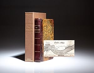
The Navigator, Containing Directions For Navigating The Monongahela, Allegheny, Ohio, And Mississippi Rivers; With An Ample Account Of These Much Admired Waters, From The Head Of The Former To The Mouth Of The Latter; And A Concise Description Of Their Towns, Villages, Harbours, Settlements, &c. With Accurate Maps Of the Ohio And Mississippi. To Which Is Added An Appendix, Containing An Account Of Louisiana, And Of The Missouri and Columbia Rivers, As Discovered By The Voyage Under Captains Lewis And Clarke
Verlag: Cramer, Spear & Eichbaum, Pittsburgh, 1811
Anbieter: The First Edition Rare Books, LLC, Cincinnati, OH, USA
Verbandsmitglied: ABAA ILAB IOBA MWABA
Verkäuferbewertung 5 von 5 Sternen
Erstausgabe Signiert
EUR 2.499,06
Währung umrechnenEUR 5,11 für den Versand innerhalb von/der USAAnzahl: 1 verfügbar
In den WarenkorbQuarter Leather. Zustand: Very good. The Seventh Edition of Zadok Cramer's Navigator, published in 1811, the most important river guide to Western waters of the Ohio and Mississippi Rivers. (illustrator). Seventh Edition. Octavo, x, [13]-295pp, [1]. Period quarter brown leather spine, paper boards, heavily worn at edges. General toning and soiling throughout. Faint dampstain to rear endpapers, limited impact on text. Previous owner's name (James Williams) written in ink on front free endpaper. Faded notes and a rough sketch on rear endpapers. Free of marginalia within text block. This work is complete with all 28 woodcut maps, including navigation charts of the Ohio and Mississippi Rivers (13 each), plus a map of Pittsburgh and one of the Falls of Ohio. (Thomson 282) (Howes C855) (Sabin 17385) A very nice example of this important guide used for travel along the Ohio and Mississippi Rivers in the early nineteenth century. "At the beginning of the 19th century, the waterways of the trans-Appalachian West were important transportation routes for emigrants, traders, and travelers. Flatboats, keelboats, and eventually steamboats carried goods and people to various destinations along the Ohio and Mississippi Rivers as well as their tributaries. River guides became standard purchases for those who traveled the western waters. One of the earliest and best-known river guides was compiled by Zadok Cramer." ("American River Guides from 1800 to 1860," AB Bookman's Weekly, July 27, 1998, p. 125) Cramer died in 1813, two years after the publication of the 7th edition of The Navigator. His wife, and eventually his daughter, took his place in the printing business, and five additional guides were published between 1814 and 1824.
-
The Navigator, Containing Directions For Navigating The Monongahela, Allegheny, Ohio, And Mississippi Rivers; With An Ample Account Of These Much Admired Waters, From The Head Of The Former To The Mouth Of The Latter; And A Concise Description Of Their Towns, Villages, Harbors, Settlements, &c. With Maps Of the Ohio And Mississippi. To Which Is Added An Appendix, Containing An Account Of Louisiana, And Of The Missouri and Columbia Rivers, As Discovered By The Voyage Under Capts. Lewis And Clark
Verlag: Cramer & Spear, Pittsburgh, 1818
Anbieter: The First Edition Rare Books, LLC, Cincinnati, OH, USA
Verbandsmitglied: ABAA ILAB IOBA MWABA
Verkäuferbewertung 5 von 5 Sternen
EUR 1.622,20
Währung umrechnenEUR 5,11 für den Versand innerhalb von/der USAAnzahl: 1 verfügbar
In den WarenkorbQuarter Leather. Zustand: Very good. Tenth edition of Zadok Cramer's Navigator, published in 1818. (illustrator). Tenth Edition. Octavo, iv, [5]-304pp. Contemporary marbled boards, rebacked in modern leather, gilt-ruled bands on spine with gilt-lettered title over leather spine label. Binding professionally restored with reinforced hinges, tissue repairs to endpapers and portions of the original leather preserved on spine edges and corners. Foxing and toning throughout. Faint dampstain to top edge of preliminary pages, tears along the edge of three pages. Previous owner's name (William Burks) written in ink on title page with another notation blacked out in ink below. Pencil notations of check marks, cross marks and numbers found on pages 162 through 194, indicating this volume may have been used by someone traveling on the Lower Mississippi River. Also, a small pencil drawing of a group of buildings on page iv. Complete with all 28 woodcut maps, including navigation charts of the Ohio and Mississippi Rivers (13 each), plus a map of Pittsburgh and one of the Falls of Ohio. Housed in brown cloth clamshell with title in gilt on spine. (Thomson 282) (Howes C855) (Sabin 17386) A very nice example of this important guide used for travel along the Ohio and Mississippi Rivers in the early nineteenth century. "At the beginning of the 19th century the waterways of the trans-Appalachian West were important transportation routes for emigrants, traders, and travelers. Flatboats, keelboats, and eventually steamboats carried goods and people to various destinations along the Ohio and Mississippi Rivers as well as their tributaries. River guides became standard purchases for those who traveled the western waters. . One of the earliest and best-known river guides was compiled by Zadok Cramer." ("American River Guides from 1800 to 1860," AB Bookman's Weekly, July 27, 1998, p. 125) Cramer died in 1813, two years after the publication of the 7th edition of The Navigator. His wife, and eventually his daughter, took his place in the printing business, and five additional guides were published between 1814 and 1824. While significant revisions were made to the eighth edition of 1814, the last four editions saw only minor changes. Among the changes made to the 10th edition of 1818 were an updated section on Pittsburgh as well as updated entries for other river towns. In this particular copy of the 10th Navigator, someone consistently checked off the individual entries from Island No. 35 [Tipton County, Tennessee] to Bayou Sara, Louisiana. There are also occasional number notations in the right margin which appear to be mileage corrections. There's an interesting drawing on page iv, which has a large building in the center, possibly a warehouse, flanked by two smaller buildings on stilts. While not certain, this copy may have been used by a flatboatman or steamboat pilot or possibly a passenger who was traveling on the Lower Mississippi River.
-
The navigator, containing directions for navigating the Monongahela, Allegheny, Ohio, and Mississippi Rivers; with an ample account of these much admired waters, from the head of the former to the mouth of the latter; and a concise description of their towns, villages, harbors, settlements, &c. with maps of the Ohio and Mississippi. To which is added an appendix, containing an account of Louisiana, and of the Missouri and Columbia Rivers, as discovered by the voyage under Capts. Lewis and Clark
Verlag: Robert Ferguson & Co. for Cramer, Spear, and Eichbaum, Pittsburgh, 1817
EUR 6.444,95
Währung umrechnenKostenlos für den Versand innerhalb von/der USAAnzahl: 1 verfügbar
In den WarenkorbHardcover. Zustand: Near fine. Ninth. Ninth edition. Pittsburgh: Robert Ferguson & Co. for Cramer, Spear, and Eichbaum, 1817. Duodecimo in 6s (6 1/2" x 4 1/8", 165mm x 106mm). [Full collation available.] With 28 full-page wood-cut river charts within the text. Bound in modern red half morocco over red cloth boards. On the spine, title gilt to head-piece, date gilt to tailpiece. With occasional mild soiling. Red numerical ink stamp to the recto of the first binder's blank, violet ink stamps of the New Bedford Free Public Library dated Oct. 1890 to the title-page and to p. 25. Zadok Cramer (1773-1814), a New Jerseyan of Quaker origin, dedicated his life to books. He opened his bookstore "Franklin Head" on Market street in Philadelphia in 1800 and established his own publication company there later. The Navigator was born out of necessity. Cramer had noticed the need for a guide to navigating the rivers that were bound west and south after he saw groups of immigrants pass through Pittsburgh asking for directions. The Navigator was published before the Louisiana Purchase in 1803, but Cramer grew interested in the Lewis and Clark expedition and was in fact the first to publish an account of the expedition as The Journal of Patrick Gass in 1807. From this account Cramer took descriptions of the Missouri and Columbia Rivers, which were added to the Navigator in 1808, and included in all subsequent editions. Additional information was added to each edition, and at the pinnacle of its popularity in 1814 it reached 360 pages. All editions after this began to shrink in size. Howes C 855; Sabin 17386.
-
The navigator, containing directions for navigating the Monongahela, Allegheny, Ohio, and Mississippi Rivers; with an ample account of these much admired waters, from the head of the former to the mouth of the latter; and a concise description of their towns, villages, harbors, settlements, &c.; with maps of the Ohio and Mississippi ; to which is added an appendix, containing an account of Louisiana, and of the Missouri and Columbia rivers, as discovered by the voyage under Capts. Lewis and Clark
Verlag: printed and published by Cramer & Spear, Franklin Head, Wood Street, Pittsburgh, 1818
Anbieter: Rulon-Miller Books (ABAA / ILAB), St. Paul, MN, USA
Verbandsmitglied: ABAA ILAB RMABA
Verkäuferbewertung 5 von 5 Sternen
EUR 2.192,16
Währung umrechnenEUR 10,22 für den Versand innerhalb von/der USAAnzahl: 1 verfügbar
In den WarenkorbTenth edition, 12mo, pp. iv, [1], 6-304; 28 full-page woodcut maps; old marbled boards, recased with a late 20th century rebacking, smooth spine with simple gilt lettering; a good, sound copy, the text block lightly toned. Important early American work on navigating the vital waterways that opened up the interior of the young United States to settlement and trade. "Most widely used guide to western waters in the early period" (Howes). Most of the maps are river sections; also includes a map of Pittsburgh, and a long description of the young city (pages 48-66). Appended is an "Abridgement of Lewis and Clark's Expedition" (pages 290-295). Erickson, Literature of Lewis and Clark, p. 105; Howes C-855; Sabin 17386.