
Gesamtpreis (1 Artikel Artikel):
Versandziel:

map quebec counties (6 Ergebnisse)
Direkt zu den wichtigsten Suchergebnissen
Suchfilter
Produktart
- Alle Product Types
- Bücher (3)
- Magazine & Zeitschriften (Keine weiteren Ergebnisse entsprechen dieser Verfeinerung)
- Comics (Keine weiteren Ergebnisse entsprechen dieser Verfeinerung)
- Noten (Keine weiteren Ergebnisse entsprechen dieser Verfeinerung)
- Kunst, Grafik & Poster (Keine weiteren Ergebnisse entsprechen dieser Verfeinerung)
- Fotografien (Keine weiteren Ergebnisse entsprechen dieser Verfeinerung)
- Karten (3)
- Manuskripte & Papierantiquitäten (Keine weiteren Ergebnisse entsprechen dieser Verfeinerung)
Zustand Mehr dazu
- Neu (Keine weiteren Ergebnisse entsprechen dieser Verfeinerung)
- Wie Neu, Sehr Gut oder Gut Bis Sehr Gut (Keine weiteren Ergebnisse entsprechen dieser Verfeinerung)
- Gut oder Befriedigend (4)
- Ausreichend oder Schlecht (1)
- Wie beschrieben (1)
Einband
- alle Einbände
- Hardcover (Keine weiteren Ergebnisse entsprechen dieser Verfeinerung)
- Softcover (2)
Weitere Eigenschaften
- Erstausgabe (1)
- Signiert (Keine weiteren Ergebnisse entsprechen dieser Verfeinerung)
- Schutzumschlag (Keine weiteren Ergebnisse entsprechen dieser Verfeinerung)
- Angebotsfoto (3)
Sprache (1)
Gratisversand
- Kostenloser Versand nach USA (Keine weiteren Ergebnisse entsprechen dieser Verfeinerung)
Land des Verkäufers
Verkäuferbewertung
-

Preliminary Aeromagnetic Map. Kinojevis : Temiscamingue and Abitibi Counties, Quebec (Canada Department of Mines and Technical Surveys, Geophysical Survey of Canada, Geophysics Paper 19).
Verlag: Canada Department of Mines and Technical Surveys., 1950
Anbieter: Eryops Books, Stephenville, TX, USA
Verkäuferbewertung 5 von 5 Sternen

Karte
No Binding. Zustand: Very Good. Large folded map in printed envelope; ex-library; in very good condition. Map.
-
Annual Report of the Quebec Bureau of Mines for the Calendar Year 1930. Part B. INCLUDES: Central - Cadillac Map - Area, Abitibi County; Clericy - Joannes Map - Area, Abitibi & Temiscamingue Counties; Venus Gold Mine, Barraute Township, Abitibi County; Gaboury - Blondeau Townships Map-Area, Temiscaminque Co.; Geological Exploration on the North Shore, Escoumains to Forestville (Mille Vaches Sheet) (Province of Quebec, Bureau of Mines).
Verlag: Province of Quebec, Bureau of Mines and R. Paradis., 1931
Anbieter: Eryops Books, Stephenville, TX, USA
Verkäuferbewertung 5 von 5 Sternen
Soft cover. Zustand: Good. ORIGINAL PUBLICATION; includes 4 folded plates in rear pocket; softcover; ex-library; light browning of leaves; light crease on upper portion of several leaves; o/w contents in very good condition. Book.
-

Map of Quebec in Counties
Verlag: Mitchell, Philadelphia, 1880
Anbieter: Main Street Fine Books & Mss, ABAA, Galena, IL, USA
Verbandsmitglied: ABAA ILAB MWABA
Verkäuferbewertung 5 von 5 Sternen
Karte
15" X 12Ľ" (image 13Ľ" X 10˝"). Hand colored. Decorative border. Near fine. Attractive copy, delicately colored and featuring inset "Environs of Montreal" detail.
-

Map of Quebec in Counties (1867)
Verlag: District Court East Pennsylvania, USA, 1867
Anbieter: Maynard & Bradley, Leicester, Vereinigtes Königreich
Verkäuferbewertung 5 von 5 Sternen
EUR 45,85
EUR 25,38 Versand
Versand von Vereinigtes Königreich nach USAAnzahl: 1 verfügbar
In den WarenkorbSoftcover. Zustand: Very Good. c.1867. A well-preserved map, lightly toned commensurate with age, but bearing only a few minor nicks and tears to margins, with no significant damage to the print itself, and colouring remaining clear and attractive. Some marginal thumb marks and nicks, but no major marks to the print itself. Why on Amazon do most sellers not describe their actual book? Buy with confidence and support a genuine Independent Bricks & Mortar Real Bookshop. We are Maynard & Bradley CAMBO & PBFA(now lapsed) members here in Leicester City Centre. Size: 360 x 300 mm. 1 pages. Item Type: Book. Quantity Available: 1. Shipped Weight: Under 500 grams. Category: Geography & Maps; Britain/UK; 19th century; Pictures of this item not already displayed here available upon request. Inventory No: 18658.
-
Map of Quebec in Counties. Environs of Montreal.
Verlag: S. Augustus Mitchell, Philadelphia, 1877
Anbieter: Alexandre Antique Prints, Maps & Books, Toronto, ON, Kanada
Verkäuferbewertung 5 von 5 Sternen
Karte
Zustand: Very Good. An attractive Map of Quebec, showing its counties and the St. Lawrence River. With an inset map showing the Environs of Montreal., Size : 270x339 (mm), 10.63x13.35 (Inches), Printed in Color with Some Hand Coloring.
-
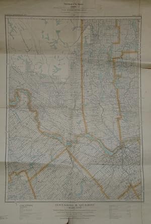
Ontario & Quebec: Ottawa (Map) Sheet - Portions of Carleton, Renfrew, Lanark, Dundas, Grenville and Frontenac Counties, Ontario, and of Pontiac, Hull, Labelle and Papineau Counties, Quebec
Verlag: Department of the Interior, Government of Canada, Ottawa, 1929
Anbieter: RareNonFiction, IOBA, Ladysmith, BC, Kanada
Verbandsmitglied: IOBA
Verkäuferbewertung 5 von 5 Sternen
Erstausgabe
Map. Zustand: Fair. First Edition. Approx. 23" x 33" standard topographical map. Coloured. Library markings. Two-inch opening to bottom edge. Shorter openings to top and right edges. Somewhat above-average wear and soiling.
