
Gesamtpreis (1 Artikel Artikel):
Versandziel:

map pakistan (58 Ergebnisse)
Direkt zu den wichtigsten Suchergebnissen
Suchfilter
Produktart
- Alle Product Types
- Bücher (31)
- Magazine & Zeitschriften (Keine weiteren Ergebnisse entsprechen dieser Verfeinerung)
- Comics (Keine weiteren Ergebnisse entsprechen dieser Verfeinerung)
- Noten (Keine weiteren Ergebnisse entsprechen dieser Verfeinerung)
- Kunst, Grafik & Poster (1)
- Fotografien (Keine weiteren Ergebnisse entsprechen dieser Verfeinerung)
- Karten (26)
- Manuskripte & Papierantiquitäten (Keine weiteren Ergebnisse entsprechen dieser Verfeinerung)
Zustand Mehr dazu
- Neu (8)
- Wie Neu, Sehr Gut oder Gut Bis Sehr Gut (10)
- Gut oder Befriedigend (23)
- Ausreichend oder Schlecht (Keine weiteren Ergebnisse entsprechen dieser Verfeinerung)
- Wie beschrieben (17)
Einband
Weitere Eigenschaften
- Erstausgabe (4)
- Signiert (Keine weiteren Ergebnisse entsprechen dieser Verfeinerung)
- Schutzumschlag (Keine weiteren Ergebnisse entsprechen dieser Verfeinerung)
- Angebotsfoto (41)
Sprache (7)
Gratisversand
Land des Verkäufers
Verkäuferbewertung
-

Pakistan Map (Nelles Map)
Anbieter: WorldofBooks, Goring-By-Sea, WS, Vereinigtes Königreich
Verkäuferbewertung 5 von 5 Sternen

EUR 6,03
EUR 6,48 Versand
Versand von Vereinigtes Königreich nach USAAnzahl: 1 verfügbar
In den WarenkorbPaperback. Zustand: Very Good. The book has been read, but is in excellent condition. Pages are intact and not marred by notes or highlighting. The spine remains undamaged.
-

Indian Subcontinent: India, Pakistan, Bangladesh, Sri Lanka (Bartholomew World Travel Map S.)
Sprache: Englisch
Verlag: HarperCollins Publishers, United Kingdom, London, 1995
ISBN 10: 0702832316 ISBN 13: 9780702832314
Anbieter: WorldofBooks, Goring-By-Sea, WS, Vereinigtes Königreich
Verkäuferbewertung 5 von 5 Sternen
EUR 10,11
EUR 6,48 Versand
Versand von Vereinigtes Königreich nach USAAnzahl: 3 verfügbar
In den WarenkorbPaperback. Zustand: Very Good. A detailed reference map of the Indian sub-continent. It covers India, Pakistan, Bangladesh and Sri Lanka. The book has been read, but is in excellent condition. Pages are intact and not marred by notes or highlighting. The spine remains undamaged.
-

Zustand: good. Befriedigend/Good: Durchschnittlich erhaltenes Buch bzw. Schutzumschlag mit Gebrauchsspuren, aber vollständigen Seiten. / Describes the average WORN book or dust jacket that has all the pages present.
-

Pakistan Map (Nelles Map)
Anbieter: WeBuyBooks, Rossendale, LANCS, Vereinigtes Königreich
Verkäuferbewertung 5 von 5 Sternen
EUR 12,48
EUR 5,05 Versand
Versand von Vereinigtes Königreich nach USAAnzahl: 1 verfügbar
In den WarenkorbZustand: Very Good. Most items will be dispatched the same or the next working day. A copy that has been read, but is in excellent condition. Pages are intact and not marred by notes or highlighting. The spine remains undamaged.
-

Zustand: Muy bueno. : El mapa de viaje Nelles de Pakistán es una guía esencial para cualquier viajero que explore la región. Con una escala de 1:1.500.000, este mapa proporciona detalles precisos de carreteras, ciudades y puntos de interés. Incluye mapas de ciudades como Lahore, Peshawar y Karachi, facilitando la navegación urbana. Publicado por Nelles Maps, este mapa es una herramienta valiosa para planificar y ejecutar viajes en Pakistán. EAN: 9783886185535 Tipo: Libros Categoría: Otros Título: Nelles Pakistan Travel Map Autor: Nelles Maps Editorial: Nelles Verlag Idioma: en Páginas: 1 Formato: map.
-
![Beispielbild für Afghanistan, Pakistan Map [Tubed] zum Verkauf von PBShop.store US](https://pictures.abebooks.com/isbn/9781597752640-de-300.jpg)
Afghanistan, Pakistan Map [Tubed]
Anbieter: PBShop.store US, Wood Dale, IL, USA
Verkäuferbewertung 5 von 5 Sternen
UNK. Zustand: Used - Very Good. Used - Like New Book. Shipped from UK. Established seller since 2000.
-

India, Pakistan and Nepal Insight Travel Map
Sprache: Englisch
ISBN 10: 9812349901 ISBN 13: 9789812349903
Anbieter: WorldofBooks, Goring-By-Sea, WS, Vereinigtes Königreich
Verkäuferbewertung 5 von 5 Sternen
EUR 14,07
EUR 6,48 Versand
Versand von Vereinigtes Königreich nach USAAnzahl: 1 verfügbar
In den WarenkorbPaperback. Zustand: Very Good. The book has been read, but is in excellent condition. Pages are intact and not marred by notes or highlighting. The spine remains undamaged.
-
Indian Subcontinent: World Travel Map : India Pakistan Bangladesh Sri Lanka (World Travel Maps)
Sprache: Englisch
Verlag: Hammond World Atlas Corp (edition Revised), 1996
ISBN 10: 0702832316 ISBN 13: 9780702832314
Map. Zustand: Very Good. Revised. It's a well-cared-for item that has seen limited use. The item may show minor signs of wear. All the text is legible, with all pages included. It may have slight markings and/or highlighting.
-
Afghanistan, Pakistan Map [Tubed]
Anbieter: PBShop.store UK, Fairford, GLOS, Vereinigtes Königreich
Verkäuferbewertung 5 von 5 Sternen
EUR 23,22
EUR 4,82 Versand
Versand von Vereinigtes Königreich nach USAAnzahl: 2 verfügbar
In den WarenkorbUNK. Zustand: Used - Very Good. Used - Like New Book. Shipped from UK. Established seller since 2000.
-
National Geographic Afghanistan, Pakistan Wall Map (21.5 X 32.5 In)
Anbieter: PBShop.store UK, Fairford, GLOS, Vereinigtes Königreich
Verkäuferbewertung 4 von 5 Sternen

EUR 24,79
EUR 4,82 Versand
Versand von Vereinigtes Königreich nach USAAnzahl: 1 verfügbar
In den WarenkorbUNK. Zustand: New. New Book. Shipped from UK. Established seller since 2000.
-
Afghanistan, Pakistan Map [Tubed]
Anbieter: PBShop.store US, Wood Dale, IL, USA
Verkäuferbewertung 5 von 5 Sternen
UNK. Zustand: New. New Book. Shipped from UK. Established seller since 2000.
-

Solid Waste Management Sector in Pakistan: A Reform Road Map for Policy Makers
Anbieter: Ria Christie Collections, Uxbridge, Vereinigtes Königreich
Verkäuferbewertung 5 von 5 Sternen
EUR 26,91
EUR 13,87 Versand
Versand von Vereinigtes Königreich nach USAAnzahl: Mehr als 20 verfügbar
In den WarenkorbZustand: New. In.
-
India, Pakistan and Nepal Insight Travel Map
Anbieter: Sell Books, Elland, YORKS, Vereinigtes Königreich
Verkäuferbewertung 5 von 5 Sternen
EUR 14,09
EUR 14,07 Versand
Versand von Vereinigtes Königreich nach USAAnzahl: 1 verfügbar
In den Warenkorbmap. Zustand: Good. Our good condition books are generally good for reading but not for gifting or collecting. They could have imperfections such as creasing, fanning, inscriptions, margin notes, yellowing, staining on edge or cover or pages, bumps, scuffs, etc etc (sometimes multiple of these). It's a wide category that encompasses anything that isn't almost-new down to anything that is slightly better than poor. We would NOT recommend gifting Good books - these should be considered reading copies. Our books are dispatched from a Yorkshire former cotton mill. We list via barcode/ISBN so please note that the images are stock images and may not be the exact copy you receive, furthermore the details about edition and year might not be accurate as many publishers reuse the same ISBN for multiple editions and as we simply scan a barcode or enter an ISBN we do not check the validity of the edition data when listing. If you're looking for an exact edition please don't order (at least not without checking with us first, although we don't always have time to check). We aim to dispatch prompty, the service used will depend on order value and book size. We can ship to most countries, see our shipping policies. Payment is via Abe only.
-
India, Pakistan and Nepal Insight Travel Map
Anbieter: Reuseabook, Gloucester, GLOS, Vereinigtes Königreich
Verkäuferbewertung 5 von 5 Sternen
EUR 16,85
EUR 11,58 Versand
Versand von Vereinigtes Königreich nach USAAnzahl: 1 verfügbar
In den WarenkorbMap. Zustand: Used; Good. Dispatched, from the UK, within 48 hours of ordering. This book is in good condition but will show signs of previous ownership. Please expect some creasing to the spine and/or minor damage to the cover. Damaged cover. The cover of is slightly damaged for instance a torn or bent corner.
-

Pakistan's Low-Carbon Energy Outlook and Technology Road Map
Anbieter: Ria Christie Collections, Uxbridge, Vereinigtes Königreich
Verkäuferbewertung 5 von 5 Sternen
EUR 36,38
EUR 13,87 Versand
Versand von Vereinigtes Königreich nach USAAnzahl: Mehr als 20 verfügbar
In den WarenkorbZustand: New. In.
-

Karte/Landkarte. Zustand: New. Karte auf Premiumpapier gedruckt, gerollt, in durchsichtiger Hartplastik-RoehreNational Geographic Wall Maps offer a special glimpse into current and historical events, and they inform about the world and environment. Offered in a variety of styles and f.
-
The Daily Telegraph Map Of The Middle East, India & Pakistan
Verlag: London, Printed in Great Britain Geographia Ltd 1977, 1977
Anbieter: PROCTOR / THE ANTIQUE MAP & BOOKSHOP, DORCHESTER, Vereinigtes Königreich
Verbandsmitglied: PBFA
Verkäuferbewertung 5 von 5 Sternen
EUR 13,12
EUR 23,16 Versand
Versand von Vereinigtes Königreich nach USAAnzahl: 1 verfügbar
In den WarenkorbColoured Folding Maps. Map Size Ca 29.5 x 40 inches In very good condition. Coloured map on paper.
-

Afghanistan, Pakistan, and the Middle East Wall Map Laminated
Sprache: Englisch
Verlag: Natl Geographic Society Maps, 2012
ISBN 10: 0792250222 ISBN 13: 9780792250227
Anbieter: Revaluation Books, Exeter, Vereinigtes Königreich
Verkäuferbewertung 5 von 5 Sternen
Karte
EUR 49,82
EUR 11,58 Versand
Versand von Vereinigtes Königreich nach USAAnzahl: 1 verfügbar
In den WarenkorbMap. Zustand: Brand New. lam map edition. 1 pages. 23.50x30.25x2.25 inches. In Stock.
-
Asian Highway Route Map. A Practical Guide to Motorists. Iran-Afghanistan-Pakistan. Route A-1 via Tehran, Kabul & Islamabad.
Verlag: Bridgestone Tire., Tokyo., 1975
Anbieter: Asia Bookroom ANZAAB/ILAB, Canberra, ACT, Australien
Verkäuferbewertung 5 von 5 Sternen
Large colour folding map in original card wrappers. 20.5 x 14cm. A very good copy.
-
[Map] The Middle East, Afghanistan, including Pakistan, Libya & Turkey - Contains the Greater Middle East Region including Iraq
Verlag: Popular Group, 2001
ISBN 10: 1590270517 ISBN 13: 9781590270516
Anbieter: Dendera, London, Vereinigtes Königreich
Verkäuferbewertung 5 von 5 Sternen
Karte
EUR 17,89
EUR 28,95 Versand
Versand von Vereinigtes Königreich nach USAAnzahl: 1 verfügbar
In den WarenkorbNo Binding. Zustand: Very Good. Colour printed sheet 97x64cm folding down into title panels 11x23cm. Very good with price sticker to the back. This was issued in the wake of 9/11 to "help you to make sense of the news and gain a clearer understanding of the events that continue to unfold". It includes 5 maps with index (Greater Middle East Region; Topography; Eastern Mediterranean; Libya; and Recent History - The Middle East since 1945); a chronology from the creation of Saudi Arabia in 1932 up to 9/11; and a panel featuring the US flag.
-

Pakistan : ITM Map 1:1200000
Sprache: Englisch
Verlag: International Travel Maps Apr 2025, 2025
ISBN 10: 1771296364 ISBN 13: 9781771296366
Anbieter: AHA-BUCH GmbH, Einbeck, Deutschland
Verkäuferbewertung 5 von 5 Sternen
Karte. Zustand: Neu. Neuware.
-

"Asie VIII" - Astrakhan Russia Russland / Lahore Pakistan / Asia Asie Asien / Karte map mapa
Sprache: Französisch
Verlag: Paris, Jean Baptiste Mitoire c. 1750., 1750
Anbieter: Antiquariat Steffen Völkel GmbH, Seubersdorf, Deutschland
Verkäuferbewertung 5 von 5 Sternen
Kunst / Grafik / Poster
Sehr seltene original Kupferstich Spielkarte aus dem 18. Jh. -- Maße: ca. 8,5 x 6 cm. -- Rückseite unbedruckt - sehr gut erhalten. || Very rare original engraved playing card from the 18th century. - verso: blank - in very good condition. // Wir, das Antiquariat Steffen Völkel, kaufen und verkaufen alte Bücher, Handschriften, Zeichnungen, Autographen, Grafiken und Fotografien. Wir sind stets am Ankauf von kompletten Bibliotheken, Sammlungen und Nachlässen interessiert. Sprache: Französisch Gewicht in Gramm: 10.
-
The Daily Telegraph Map of the Middle East, India & Pakistan (Daily Telegraph Map Series)
Sprache: Englisch
Verlag: The Daily Telegraph, London, 1968
ISBN 10: 0092047009 ISBN 13: 9780092047008
Anbieter: Dendera, London, Vereinigtes Königreich
Verkäuferbewertung 5 von 5 Sternen
Karte
EUR 119,26
EUR 28,95 Versand
Versand von Vereinigtes Königreich nach USAAnzahl: 1 verfügbar
In den WarenkorbSoft cover. Zustand: Fine. Subtitled "Political Map with Insets showing Details of Population, Religion, Economic Distribution, and Comparative Distances, and Additional Commercial Information". Colour printed paper 102x76cm with accompanying card title leaf with data about countries covered to the verso. Map fine, neatly folded as issued, title card about very good. Undated but c1968-70, after the formation of South Yemen (30 Nov 1967) and before the formation of the UAE and independence of Bangladesh. (No edition is stated, but Worldcat entries estimate 1965-77). Coverage is bounded by Yugoslavia (NW), the Mongolian People's Republic (NE), Ceylon and Burma (SE), and Ethiopia (SW) on a scale of 1/7M. This is highly detailed, with several dozen captions giving interesting facts, noting for example the best Arabian camels are bred in Muscat and Oman, the status of the Kurds, the importance of oil and carpets to Iran, Afghanistan's demands for a Pathan state, India's total irrigated area, etc, with much on natural resources. This is fairly common institutionally, but appears to be quite scarce in commerce.
-
Pakistan | ITM Map 1:1200000
Sprache: Englisch
Verlag: International Travel Maps, 2025
ISBN 10: 1771296364 ISBN 13: 9781771296366
Karte
(Land-)Karte. Zustand: Neu. Pakistan | ITM Map 1:1200000 | (Land-)Karte | ITM Map | Englisch | 2025 | International Travel Maps | EAN 9781771296366 | Verantwortliche Person für die EU: GeoCenter TMS GmbH, Kurze Str. 40, 70794 Filderstadt, gpsr[at]geocenter[dot]de | Anbieter: preigu.
-

"Cambaia" - India Pakistan Kathiawar peninsula map Karte carte
Sprache: Französisch
Verlag: Amsterdam, J. Hondius, 1618
Anbieter: Antiquariat Steffen Völkel GmbH, Seubersdorf, Deutschland
Verkäuferbewertung 5 von 5 Sternen
Karte Erstausgabe
Original Kupferstich-Karte aus der ersten französischen Ausgabe von Bertius' "Atlas Minor" gedruckt in Amsterdam bei J. Hondius im Jahre 1618. Mit französischem Text auf der Rückseite. -- Blatt-Maße: ca. 12 x 17,5 cm. -- nur leicht fleckig, sonst gut erhalten. || Original engraved map out of the first French edition of Bertius' "Atlas Minor", published by J. Hondius in Amsterdam in 1618. With French text on verso. -- only slightly stained, otherwise in good condition. // Wir, das Antiquariat Steffen Völkel, kaufen und verkaufen alte Bücher, Handschriften, Zeichnungen, Autographen, Grafiken und Fotografien. Wir sind stets am Ankauf von kompletten Bibliotheken, Sammlungen und Nachlässen interessiert. Sprache: Französisch Gewicht in Gramm: 10.
-
Asian Highway Route Map: Iran- Afghanistan- Pakistan. Route A- 1 via Tehran, Kabul & Islamabad. A Practical Guide to Motorists.
Verlag: ESCAP/ Bridgestone Tire Co., Tokyo, 1978, 1978
Anbieter: ROBIN SUMMERS BOOKS LTD, Aldeburgh, Vereinigtes Königreich
Verkäuferbewertung 5 von 5 Sternen
Karte
EUR 47,70
EUR 33,58 Versand
Versand von Vereinigtes Königreich nach USAAnzahl: 1 verfügbar
In den WarenkorbZustand: Very Good. Second edition. Paperback. 3 large colour folding maps on 2 double-sided folding sheets, each 36 x 15 inches, scale 1:1250000, 1 inch to 20 miles. Folds down to octavo, 5.5 x 8 inches. Light wear otherwise very good indeed. Excellent condition.
-
PROVINCE MAP OF PUNJAB AND BAHAWALPUR - FIRST EDITION - PUBLISHED UNDER THE DIRECTION OF THE SURVEYOR GENERAL OF PAKISTAN 1953
Sprache: Englisch
Verlag: Survey Of Pakistan, Pakistan, 1953
Anbieter: Hornseys, Ripon, Vereinigtes Königreich
Verbandsmitglied: PBFA
Verkäuferbewertung 5 von 5 Sternen
Erstausgabe
EUR 655,93
EUR 28,95 Versand
Versand von Vereinigtes Königreich nach USAAnzahl: 1 verfügbar
In den WarenkorbNo Binding. Zustand: Very Good. 1st Edition. Size: 63.3cm x 85.5cm. A detailed map of the region on a good scale of 1 inch to 15.78 miles. Original fold lines and creasing. Minor wear to the fold intersections with a very minor amount of loss. A few areas of very minor age toning and marks. Reverse is blank with very minor age toning and marks. In very good, original and unrestored condition. Very scarce.
-
Peshawar Guide Map - Pakistan - Published Under The Direction Of Brigadier H J Couchman - Surveyor General Of India 1935
Sprache: Englisch
Verlag: Survey of India, Calcutta, India, 1935
Anbieter: Hornseys, Ripon, Vereinigtes Königreich
Verbandsmitglied: PBFA
Verkäuferbewertung 5 von 5 Sternen
Erstausgabe
EUR 1.132,98
EUR 28,95 Versand
Versand von Vereinigtes Königreich nach USAAnzahl: 1 verfügbar
In den WarenkorbNo Binding. Zustand: Good. 1st Edition. Surveyor General: Brigadier H. J. Couchman. Publisher: The Survey Of India, Calcutta. Price: Ł950. Publication Date: 1935. Edition: First edition. Format: Heliozincograph. Condition: Good condition, unframed. Sheet Size: Sheet Size: 71.5cm x 111.4cm. Scale: 6 inches to 1 miles: 1:10560. Condition: Original fold lines into 24 sections with minor age toning and marks. Closed tears to fold lines. Small areas of loss at fold intersections with a small amount of loss to the left margin, not affecting the map. Reverse is blank with minor age toning and a few pencil marks. 'For Official Use Only' stamp to the upper margin. Minor pencil notes to upper margin. In original and unrestored condition. Exceptionally scarce. Location: Map Drawer C: FS: Folder 1220. Description: A highly detailed map on a scale of 6 inches to 1 mile. Identified points include both unfenced, fenced, walled of barbed wire gardens, lanes and important buildings in the city, streams, canals and embankments, roads and tracks, camping and sporting grounds and pitches, and mosques and temples. No copies are held institutionally. Only one other known copy of this, the first edition this map has been recorded.
-

A Guide for Travellers in India and Pakistan : a complete guide to all the historical and important cities and to the interisting places in India and Pakistan, with information on rail, steamer and air routes. With Map of India & Pakistan. 4., rev. ed.
Verlag: Bombay, Taraporevala (1953)., 1953
Anbieter: Antiquariat Löcker, Wien, Österreich
Verbandsmitglied: GIAQ ILAB VDA VDAO
Verkäuferbewertung 5 von 5 Sternen
xvi, 250 S., mit einer mehrfach gefalt. Karte, OPappband, farb. OUmschl., dieser mit geklebten Randläsuren, Innen neuwertig, wie unbenutzt. In engl. Sprache.
-
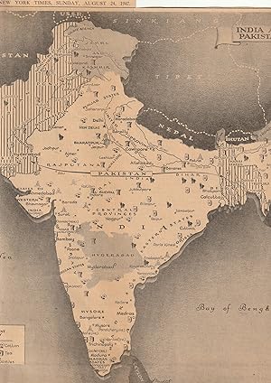
DIVISION OF INDIA INTO PAKISTAN INDIA & PRINCELY STATES 1947 MAP
Verlag: THE NEW YORK TIMES, 1947
Karte Erstausgabe
No Binding. Zustand: Very Good. 1st Edition. Kashmir India Pakistan Independence MAP THEY DECIDE THE BOUNDARIES PAKISTAN INDIA & PRINCELY STATES SHOWS US THE WHERE OF THE BORDERS. SUNDAY AUGUST 24, 1947 ORIGINAL MAP NEWSPAPER CLIPPING 11 1/2" X 11 1/2".India and Pakistan date back to their birth as sovereign nations, in August 1947,as the British pull out and end their rule. Black white and grey tones original The New York Times printing. L Manditch cartographer with a note at the bottom about the formerly princely states of British India: "Bahawalpur Kahaipur and Kalat are included in Pakistan."Kashmir according to this printing was an "Independent Princely State" Original clipping from the newspaper No chips or tears or unwanted marks.


![Bild des Verkäufers für [Map] The Middle East, Afghanistan, including Pakistan, Libya & Turkey - Contains the Greater Middle East Region including Iraq zum Verkauf von Dendera](https://pictures.abebooks.com/inventory/md/md31743220427.jpg)


