

Gesamtpreis (1 Artikel Artikel):
Versandziel:

map long island (40 Ergebnisse)
Direkt zu den wichtigsten Suchergebnissen
Suchfilter
Produktart
- Alle Product Types
- Bücher (24)
- Magazine & Zeitschriften (Keine weiteren Ergebnisse entsprechen dieser Verfeinerung)
- Comics (Keine weiteren Ergebnisse entsprechen dieser Verfeinerung)
- Noten (Keine weiteren Ergebnisse entsprechen dieser Verfeinerung)
- Kunst, Grafik & Poster (Keine weiteren Ergebnisse entsprechen dieser Verfeinerung)
- Fotografien (Keine weiteren Ergebnisse entsprechen dieser Verfeinerung)
- Karten (16)
- Manuskripte & Papierantiquitäten (Keine weiteren Ergebnisse entsprechen dieser Verfeinerung)
Zustand Mehr dazu
- Neu (8)
- Wie Neu, Sehr Gut oder Gut Bis Sehr Gut (4)
- Gut oder Befriedigend (9)
- Ausreichend oder Schlecht (Keine weiteren Ergebnisse entsprechen dieser Verfeinerung)
- Wie beschrieben (19)
Einband
Weitere Eigenschaften
- Erstausgabe (2)
- Signiert (1)
- Schutzumschlag (Keine weiteren Ergebnisse entsprechen dieser Verfeinerung)
- Angebotsfoto (27)
Sprache (3)
Gratisversand
Land des Verkäufers
Verkäuferbewertung
-

Bathymetric Map C. & G. S. 0808N-54. South of Long Island. Mercator Projection, Scale 1:125,000 at Latitude 40 deg. (United States Department of Commerce, Coast and Geodetic Survey / U. S. Department of the Interior, Fish and Wildlife Service, Bureau of Commercial Fisheries).
Verlag: United States Department of Commerce, Coast and Geodetic Survey / U. S. Department of the Interior, Fish and Wildlife Service, Bureau of Commercial Fisheries., 1967
Anbieter: Eryops Books, Stephenville, TX, USA
Verkäuferbewertung 5 von 5 Sternen

No Binding. Zustand: Good. Large Folded Bathymetric Map; ex-corporate library; a couple of tears along edge (does not touch map image), creasing on lower corner, o/w in good condition. Map.
-
Bathymetric Map C. & G. S. 0808N-53. Long I. Sound / Long Island Sound. Mercator Projection, Scale 1:125,000 at Latitude 40 deg. (United States Department of Commerce, Coast and Geodetic Survey / U. S. Department of the Interior, Fish and Wildlife Service, Bureau of Commercial Fisheries).
Verlag: United States Department of Commerce, Coast and Geodetic Survey / U. S. Department of the Interior, Fish and Wildlife Service, Bureau of Commercial Fisheries., 1967
Anbieter: Eryops Books, Stephenville, TX, USA
Verkäuferbewertung 5 von 5 Sternen
No Binding. Zustand: Good. Large Folded Bathymetric Map; ex-corporate library; chip on top edge (does not touch map image), small tear where folded, o/w in good condition. Map.
-

Rand McNally New York City/Long Island Regional Map
Anbieter: PBShop.store UK, Fairford, GLOS, Vereinigtes Königreich
Verkäuferbewertung 4 von 5 Sternen

EUR 14,65
EUR 3,82 Versand
Versand von Vereinigtes Königreich nach USAAnzahl: 15 verfügbar
In den WarenkorbUNK. Zustand: New. New Book. Shipped from UK. Established seller since 2000.
-

Documents Relating to the History of the Early Colonial Settlements Principally on Long Island: With a Map of Its Western Part, Made in 1666; Translated, Compiled and Edited From the Original Records in the Office of the Secretary of State and the State L
Anbieter: PBShop.store US, Wood Dale, IL, USA
Verkäuferbewertung 5 von 5 Sternen
PAP. Zustand: New. New Book. Shipped from UK. Established seller since 2000.
-
Documents Relating to the History of the Early Colonial Settlements Principally on Long Island: With a Map of Its Western Part, Made in 1666; Translated, Compiled and Edited From the Original Records in the Office of the Secretary of State and the State L
Anbieter: PBShop.store UK, Fairford, GLOS, Vereinigtes Königreich
Verkäuferbewertung 4 von 5 Sternen
EUR 32,58
EUR 7,84 Versand
Versand von Vereinigtes Königreich nach USAAnzahl: 15 verfügbar
In den WarenkorbPAP. Zustand: New. New Book. Shipped from UK. Established seller since 2000.
-

Long Island, The Bahamas, Dive Map & Reef Creatures Identification Guide
Anbieter: Revaluation Books, Exeter, Vereinigtes Königreich
Verkäuferbewertung 5 von 5 Sternen
Karte
EUR 19,23
EUR 11,60 Versand
Versand von Vereinigtes Königreich nach USAAnzahl: 1 verfügbar
In den WarenkorbMap. Zustand: Brand New. 2 pages. 8.50x5.50x0.10 inches. In Stock.
-

Red Map Brooklyn with Long Island City - City Travel Guide
Anbieter: WeBuyBooks, Rossendale, LANCS, Vereinigtes Königreich
Verkäuferbewertung 5 von 5 Sternen
EUR 25,81
EUR 5,43 Versand
Versand von Vereinigtes Königreich nach USAAnzahl: 1 verfügbar
In den WarenkorbZustand: Good. Most items will be dispatched the same or the next working day. A copy that has been read but remains in clean condition. All of the pages are intact and the cover is intact and the spine may show signs of wear. The book may have minor markings which are not specifically mentioned.
-
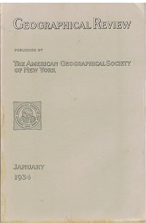
Geographical Review, January 1934. Vol. XXIV No. 1. Vol. 24. articles: Long Beach earthquake; A recent survey in Little Tibet (40 pages, several b/w illustrations and a large coloured map of the Eastern Karakoram); white settlement in Saba Island, Dutch West Indies; the population of the Malay Peninsula; Murray River basin; An Eskimo discovery of an island North of Alaska; Discovery of a new sketch of Cape Hudson in the Antarctic; Altitude and location of Minya Konka;
Sprache: Englisch
Verlag: The American Geographical Society of New York, New York, 1934
Anbieter: Tinakori Books, Lower Hutt, Neuseeland
Verkäuferbewertung 5 von 5 Sternen
Erstausgabe
Soft cover. Zustand: Very Good. 1st Edition. p. 1- 176. Some articles: Long Beach earthquake; A recent survey in Little Tibet (40 pages, several b/w illustrations and a large coloured map of the Eastern Karakoram); white settlement in Saba Island, Dutch West Indies; the population of the Malay Peninsula; Murray River basin; An Eskimo discovery of an island North of Alaska; Discovery of a new sketch of Cape Hudson in the Antarctic; Altitude and location of Minya Konka; and other articles.
-

Documents Relating to the History of the Early Colonial Settlements Principally on Long Island: With a Map of Its Western Part, Made in 1666; Translated, Compiled and Edited From the Original Records in the Office of the Secretary of State and the State L
Anbieter: PBShop.store US, Wood Dale, IL, USA
Verkäuferbewertung 5 von 5 Sternen
HRD. Zustand: New. New Book. Shipped from UK. Established seller since 2000.
-
Documents Relating to the History of the Early Colonial Settlements Principally on Long Island: With a Map of Its Western Part, Made in 1666; Translated, Compiled and Edited From the Original Records in the Office of the Secretary of State and the State L
Anbieter: PBShop.store UK, Fairford, GLOS, Vereinigtes Königreich
Verkäuferbewertung 4 von 5 Sternen
EUR 38,47
EUR 8,85 Versand
Versand von Vereinigtes Königreich nach USAAnzahl: 15 verfügbar
In den WarenkorbHRD. Zustand: New. New Book. Shipped from UK. Established seller since 2000.
-

White's Pharmacy and Department Store Promotional Map of Montauk, Long Island, New York, Featuring White's Pharmacy
Verlag: White's Pharmacy, New York, 1958
Anbieter: Bookshelf of Maine, Franklin, ME, USA
Verkäuferbewertung 5 von 5 Sternen
Karte
Map. Zustand: Very Good+. The White's Pharmacy was started in Montauk in 1928. This is a two-sided flyer with a map on one side featuring all the places of unusual interest in the Montauk area, and on the reverse a store layout of White's Pharmacy locating all the various departments. Scarce item. ;
-

Zustand: Sehr gut. Zustand: Sehr gut | Sprache: Englisch | Produktart: Bücher | Keine Beschreibung verfügbar.
-
Zustand: Hervorragend. Zustand: Hervorragend | Sprache: Englisch | Produktart: Bücher | Keine Beschreibung verfügbar.
-

Der Seeboden aus der atlantischen Küste der Vereinigten Staaten von Nordamerika. Nach den Untersuchungen der Nordamerikanischen Coast Survey von L. F. von Pourtales. - Der Seeboden bei Long Island. - Der Seeboden zwischen Florida und Cuba. Petermann, A. Der Seeboden aus der atlantischen Küste der Vereinigten. Antique Map, Lithograph 246 x 306mm Justus Perthes., Gotha 1870
Verlag: Justus Perthes., Gotha, 1870
Anbieter: Antiquariat Reinhold Berg eK Inh. R.Berg, Regensburg, Deutschland
Verkäuferbewertung 5 von 5 Sternen
Karte
Other. Lithograph, original color in outline by Petermann, A, published 1870 by Justus Perthes, Gotha. Image size: 246 by 306mm (9 by 12 inches). Published in Petermanns Geographische Mittheilungen the world's most respected cartographic journal of the 19th century. August Heinrich Petermann (18221878) was one of the most influential cartographers of the 19th century. Born in Bleicherode, Germany, he studied at the renowned Geographical School of Art in Potsdam under Heinrich Berghaus and later worked in London and Edinburgh before returning to Germany to direct Justus Perthes' Geographical Institute in Gotha. In 1855 he founded Petermanns Geographische Mittheilungen, which rapidly became the world's most respected cartographic journal. Petermann pioneered the use of statistical and thematic mapping depicting population distribution, geological formations, ocean depths, and political data with new visual rigor. His maps, published in Gotha, set the international standard for scientific cartography in the second half of the 19th century and are today highly prized by collectors for their intellectual depth and technical perfection.A highly interesting map of the eastern seaboard depicting the sea bed of the atlantic ocean. Three maps on one sheet: The east coast from Massachusetts to Florida, Long Island and the region between Florida and Cuba. In very good condition. In very good condition. 246 by 306mm (9 by 12 inches). 246 by 306mm (9 by 12 inches).
-

Der Seeboden an der atlantischen Küste der Vereinigten Staaten von Nordamerika. Nach den Untersuchungen der Nordamerikanischen Coast Survey von L.F. von Pourtales. - Der Seeboden bei Long Island. - Der Seeboden zwischen Florida und Cuba. Petermann, A. Der Seeboden an der atlantischen Küste der Vereinigten. Antique Map, Lithograph 247 x 306mm Justus Perthes., Gotha 1870
Verlag: Justus Perthes., Gotha, 1870
Anbieter: Antiquariat Reinhold Berg eK Inh. R.Berg, Regensburg, Deutschland
Verkäuferbewertung 5 von 5 Sternen
Karte
Other. Lithograph, original color in outline by Petermann, A, published 1870 by Justus Perthes, Gotha. Image size: 247 by 306mm (9 by 12 inches). Published in Petermanns Geographische Mittheilungen the world's most respected cartographic journal of the 19th century. August Heinrich Petermann (18221878) was one of the most influential cartographers of the 19th century. Born in Bleicherode, Germany, he studied at the renowned Geographical School of Art in Potsdam under Heinrich Berghaus and later worked in London and Edinburgh before returning to Germany to direct Justus Perthes' Geographical Institute in Gotha. In 1855 he founded Petermanns Geographische Mittheilungen, which rapidly became the world's most respected cartographic journal. Petermann pioneered the use of statistical and thematic mapping depicting population distribution, geological formations, ocean depths, and political data with new visual rigor. His maps, published in Gotha, set the international standard for scientific cartography in the second half of the 19th century and are today highly prized by collectors for their intellectual depth and technical perfection.A highly interesting map of the eastern seaboard depicting the sea bed of the atlantic ocean. Three maps on one sheet: The east coast from Massachusetts to Florida, Long Island and the region between Florida and Cuba. In excellent condition. In excellent condition. 247 by 306mm (9 by 12 inches).
-

Vintage Lined Notebook Greetings from Long Island, New York, Map
Anbieter: AHA-BUCH GmbH, Einbeck, Deutschland
Verkäuferbewertung 5 von 5 Sternen
Taschenbuch. Zustand: Neu. Neuware.
-

New York: Including insets of Albany, Buffalo, Niagara Falls NY-ON, Rochester, Syracuse, Utica, plus Long Island map . toll & ferry information by AAA (Organization : U.S.) (2002-01-01)
Sprache: Englisch
Verlag: AAA; 2002 ed edition (2002-01-01), 1656
ISBN 10: 1562517309 ISBN 13: 9781562517304
Zustand: very good. Gut/Very good: Buch bzw. Schutzumschlag mit wenigen Gebrauchsspuren an Einband, Schutzumschlag oder Seiten. / Describes a book or dust jacket that does show some signs of wear on either the binding, dust jacket or pages.
-

Bird's Eye View Map of East and North Rivers and Long Island Sound
Verlag: C.S. Hammond and Company, New York, 1912
Anbieter: Mare Booksellers ABAA, IOBA, Dover, NH, USA
Verbandsmitglied: ABAA ILAB IOBA
Verkäuferbewertung 5 von 5 Sternen
Wraps. Zustand: Very Good. Mustard yellow card stock covers 7 ½ by 3 ½ inches. Fold out color illustrated map, measuring 23 ½ by 18 inches. Single sided. A bird's eye view map of the New York region of Long Island Sound, and the East and North Rivers. VERY GOOD condition. Minor wrinkling and toning to the covers, with some wrinkling and browning to the map.
-

Vintage Lined Notebook Greetings from Long Island, New York, Map
Verlag: Found Image Press Inc. Aug 2023, 2023
ISBN 13: 9798385419951
Anbieter: AHA-BUCH GmbH, Einbeck, Deutschland
Verkäuferbewertung 5 von 5 Sternen
Taschenbuch. Zustand: Neu. Neuware.
-
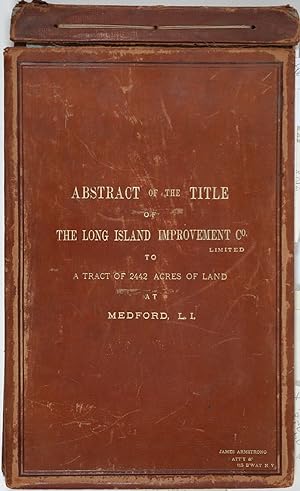
Abstract of the Title of the Long Island Improvement Co. Limited to a Tract of 2442 Acres of Land at Medford, L. I. With a Manuscript, folding, hand colored map
Verlag: Riverhead, New York, 1885
Anbieter: Antipodean Books, Maps & Prints, ABAA, Garrison, NY, USA
Verbandsmitglied: ABAA ANZAAB ESA ILAB
Verkäuferbewertung 3 von 5 Sternen

Signiert
Hardcover. Zustand: Very good condition. The original manuscript title to a very large tract of land near Brookhaven Long Island acquired by John A. Bowman from the individual proprietors and conveyed here by Bowman in its entirety to the Long Island Improvement Company Ltd. The Long Island Improvement Company was formed by Austin Corbin, then president of the L. I. Rail Road and others in 1881. Corbin sought the land in order to develop expensive summer residences on Long Island; Bowman was acting as Corbin's agent in the acquisition of this valuable property. Austin Corbin (1827 1896) was an American railroad executive, plantation owner, resort operator, banker and robber baron. In Iowa, as a bank president, he engaged in mortgage scams. Later, through theft and corruption he consolidated the individual rail lines into the profitable Long Island Rail Road. He was widely despised in his day: Puck (Sept 1882) printed a caricature in which Corbin appears at a Louis XIV styled party, where he carouses with Jay Gould and other robber barons. The Abstract, a bound sml. folio volume, records that Bowman paid $5 per acre for most of the parcels in 1882, then conveyed (January of 1883) the incalculably valuable entire tract to the LI Improvement Co for $1. The Abstract volume concludes with the Suffolk County embossed seal and is signed by the Clerk at Riverhead, 1st June 1885. It includes the ownership history of each parcel, as well as a history of the town of Brookhaven from its founding. The Abstract volume is accompanied by the original hand colored manuscript map on architectural vellum of the entire tract with silk ribbon binding, showing the 25 property owner names and parcel sizes. Surveys were conducted by Justus Roe. The map is titled, "Map of Property of the Long Island Improvement Company (Limited) at Medford LI". The scale is 300 feet to the inch. The northern boundary of the tract shows the Brewster Terry Property and Horse Block Road; the western edge defined by Tunnel and Progues Road and the Austin Roe and Daniel Gerard property; the southern boundary with Georgianna Rider property and Canaan and Medford Roads; the eastern boundary with the Robinson property and Lime Road. The Long Island RR can be seen running from east to west at approximately one third of the way through the tract at the north side. The map signed in ink at the lower right corner, E. H. H. Forder. The Abstract bound in full gilt tan leather, 9 x 14 3/4", attorney's name stamped in gilt at lower corner, James Armstrong, Attny 115 B'Way, N. Y. Boards slightly rubbed; front board detached but present. Pages very bright and clean. The map 67 x 44", a few short splits at folds, but very bright and clean, in very good + condition. A remarkable record of Long Island land speculation in the late 1880s.
-
Hagstrom's Street and Road Map of Farmingdale, Hicksville, Levittown, Long Island, N.Y.
Verlag: Hagstrom Company, New York, 1951
Anbieter: Argosy Book Store, ABAA, ILAB, New York, NY, USA
Verkäuferbewertung 5 von 5 Sternen
pamphlet. Map. Lithograph. Pamphlet measures 7 5/8" x 4 1/4". Map measures 36" x 18 1/2" Crisp mid-century folding map depicting part of Nassau County, New York. The map extends from Syosset to Massapequa, featuring the towns of Hicksville, Levittown, Bethpage, Farmingdale, and Plainview. Streets and roads are extensively labeled, as well as railroads, parks, golf courses, airports, post offices, train stations, and other major sites are labeled. An inset in the upper let corner depicts the greater New York area, showing major state roads in the region. A street and avenue index is included in the lower margin. Published in 1951, this map offers a fascinating glimpse at the development of America's first suburb, built just four years prior. In excellent condition. Andrew Hagstrom, a Swedish-born mapmaker, founded Hagstrom Company in New York City in 1916, publishing regional, street, and road maps. His maps became widely popular in the New York metropolitan area around the 30s and 40s, winning many contracts with the city of New York. His elevated and subway map was printed in the telephone directories for the five boroughs through the 40s and 50s. This map is a wonderful example of Hagstrom's style during its most prolific period.
-

'NEW YORK - CITY AND VICINITY'. Map of New York, New Jersey, Brooklyn, parts of Long Island, Bergen, etc. For Encyclopaedia Britannica engraved by
Verlag: W. & A. K. Johnston ca. 1880, 1880
Anbieter: Garwood & Voigt, Sevenoaks, Vereinigtes Königreich
Verkäuferbewertung 5 von 5 Sternen
Karte
EUR 89,60
EUR 34,79 Versand
Versand von Vereinigtes Königreich nach USAAnzahl: 1 verfügbar
In den WarenkorbZustand: Fine. 34x24cm. Printed in full colours. Excellent condition.
-

Index Map No. 1 of a Part of Suffolk County, South Side-Ocean Shore Long Island.; Townships of Babylon and Part of Islip
Verlag: E. Belcher Hyde, Brooklyn, NY, 1970
Anbieter: Argosy Book Store, ABAA, ILAB, New York, NY, USA
Verkäuferbewertung 5 von 5 Sternen
3 maps on one sheet. Uncolored lithograph. Image measures 15" x 25", Reprinted in 1970 from a 1915 edition. This map appeared as the index for Vol. 1 of E. Belcher Hyde's 1915 "Atlas of a Part of Suffolk County, Long Island, New York." The map extends from the Nassau County border line, near Amityville and Farmingdale, to Knickerbocker Ave near Ronkonkoma and Sayville. Includes islands and beaches surrounding Oak Island and Fire Island. The area is divided and numbered to correspond with the following atlas plates. Major roads, railways, town grids, parks and cemetarys, and waterways are labeled. Features a graphic compass rose and decorative border. It is a dark impression on bright paper and in excellent condition. Small chips and tears to margins not affecting the image. The publishing house of E. Belcher Hyde created maps primarily for the fire insurance industry beginning in the 1890s. While much of their work was concentrated in urban areas such as metropolitan New York, the company also mapped the growing developments on nearby Long Island. Today, these maps are valued as research tools because of their detail and accuracy. As such, they offer fascinating insight into the history of this now densely-populated area. Left in its original uncolored state, this map is a beautiful complement to any collection or decor.
-
1936 Road Map: Metropolitan New York and Long Island
Verlag: Shell: 1936, 1936
Anbieter: Antikvariat Valentinska, Praha, Tschechien
Verbandsmitglied: ILAB
Verkäuferbewertung 5 von 5 Sternen
Folding pocket map, 70 x 70 cm, slightly worn, one fold torn, some other folds very slightly torn, condition: very good Book Language/s: English.
-

'CARTE GÉNÉRALE DES ÉTATS-UNIS ET DU MEXIQUE COMPRENANT L'AMÉRIQUE CENTRALE ET LES ANTILLES'. Large map of the United States, Mexico and West Indies, with inset maps of Central America, Lesser Antilles, New York and Long Island, and the Atlantic connections to Europe. The advancing and existing railway lines to the West are of great interest. Printed on two sheets
Verlag: Eugene Andriveau-Goujon ca. 1875, 1875
Anbieter: Garwood & Voigt, Sevenoaks, Vereinigtes Königreich
Verkäuferbewertung 5 von 5 Sternen
Karte
EUR 107,51
EUR 34,79 Versand
Versand von Vereinigtes Königreich nach USAAnzahl: 1 verfügbar
In den WarenkorbZustand: Fine. 63x92cm, when joined. Full original colour. Excellent condition.
-

A Map of Western Long Island Sound: Showing Yacht Clubs, Aids to Navigation and Principal Larchmont Race Courses.
Erscheinungsdatum: 1939
Anbieter: Geographicus Rare Antique Maps, Brooklyn, NY, USA
Verbandsmitglied: ABAA ESA ILAB
Verkäuferbewertung 4 von 5 Sternen
Karte
Soft cover. Very good. Thread holes at centerfold. Size 14 x 22 Inches. This is a delightful 1939 Rolf Klep pictorial map of western Long Island Sound. It covers the waters off Westchester County, Fairfield County, and the 'Gold Coast' of Long Island, specifically those frequented by the members of the Larchmont Yacht Club. A note on the verso describes this as 'a Yachting Paradise' and 'the most populous yachting center in the world, with about fifty clubs lining some seventeen miles of Long Island Sound.' The locations of indeed fifty yachting clubs are marked with flags on the map, as are lighthouses, buoys, and radio beacons. The routes of seven Larchmont Regatta race courses are shown in white overlapping triangles throughout the Sound. Though soundings are not numbered, depths are indicated by varying shades, the darkest showing the deepest water, over 120 feet. Ebb and flood tides are marked on the map with arrows, as are key landmarks used by yachtsmen to take compass bearings - chimneys, domes, water towers, and even specific houses. Despite the map's richness of detail, the author of the article it accompanied was at pains to explain that 'though accurate, this map should not be used for navigation' directing the reader instead to consult the U.S. Coast and Geodetic Survey and Texaco cruising charts from which the map's data was drawn. Labor of Love by a Self-Proclaimed 'River Rat' While the mapmaker and illustrator Klep would become famous for his cutout diagrams of aircraft, ships, and spacecraft of the future, he had a love of sailing. He grew up on the Columbia River in Oregon, worked deck jobs on tourist ferries, and nurtured a lifetime fascination with ships. On his retirement, Klep returned to Oregon to found the Columbia River Maritime Museum. Publication History and Census This map was produced in one edition, appearing in a 1939 Fortune Magazine . It only appears cataloged as a separate map once in OCLC, in the Harvard University Botany Libraries. Neglected rather than rare, examples appear on the market from time to time. References: Rumsey 9716.000. OCLC 955691094.
-
Railroad Map and Business Guide in Book Form . 1886-1887 . Embracing the Principle Manufacturers, Trades, Professions, and Representative Business Houses of Long Island City, L.I., N.Y., Corona, Woodside, Locust Grove, Maspeth, Winfield . [etc.]
Verlag: Hannifan & Co, Buffalo, 1887
Anbieter: James Cummins Bookseller, ABAA, New York, NY, USA
Verkäuferbewertung 5 von 5 Sternen
Large folding color railroad map by Rand McNally, with advertisements around the outside border of the map, and with a profusion of advertisements printed on verso. 26x41 inches. The map by Rand McNally depicts the U.S. as far west as Fort Bliss, Texas, with the nation's numerous railroad routes identified. The map was evidently a stock map issued by Rand McNally and licensed by Hannifan & Co. to produce a series of such regional business directories. The present directory focusses on Queens and Long Island, though other extant examples have ads for businesses in upstate New York, New Jersey and elsewhere. Scarce. Folds into publisher's cloth backed orange boards, advertisements on both covers and on the pastedowns. Minor separations at folds Large folding color railroad map by Rand McNally, with advertisements around the outside border of the map, and with a profusion of advertisements printed on verso. 26x41 inches.
-
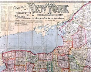
'SCARBOROUGH'S NEW RAIL-ROAD, POST OFFICE, TOWNSHIP, AND COUNTY MAP OF NEW YORK WITH DISTANCES BETWEEN STATIONS.'. Large and detailed folding (wall) map of the State of New York with two inset maps of Long Island and the City of New York. Published in Boston by the
Verlag: Scarborough Company 1903, 1903
Anbieter: Garwood & Voigt, Sevenoaks, Vereinigtes Königreich
Verkäuferbewertung 5 von 5 Sternen
Karte
EUR 537,57
EUR 34,79 Versand
Versand von Vereinigtes Königreich nach USAAnzahl: 1 verfügbar
In den WarenkorbZustand: Fine. 101x114cm. Printed in full colours. Laid down on linen, not dissected. Occasional wear to crossfolds, otherwise excellent condition.
-
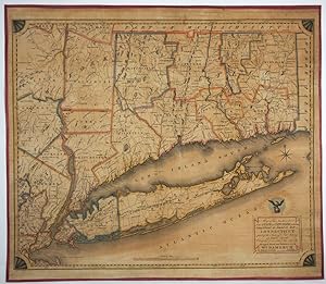
Map of the Southern part of the State of New York including Long Island, the Sound, the State of Connecticut, part of the State of New Jersey and Islands adjacent
Verlag: Wm. Damerum, New York, 1815
Anbieter: Antipodean Books, Maps & Prints, ABAA, Garrison, NY, USA
Verbandsmitglied: ABAA ANZAAB ESA ILAB
Verkäuferbewertung 3 von 5 Sternen
Rare wall map of the Tri-state area including all of Connecticut and Long Island, by Wm. Damerum "General Surveyor". A handsome engraving by Peter Maverick of the Maverick engraving family. Stephens (The Mavericks) 1121, second state with âSchyler's copper mines.' (in North Arlington, Bergen County, New Jersey.) Streeter Sale 900: "This map shows Long Island on an unusually large scale for such an early map. Thompson . describes the map as âA handsome engraving, quite rare. The thirteen Connecticut towns that were incorporated in the first decade of the century are shown." Original hand color in outline with some counties with wash color. Professionally laid on canvas, with pink silk border. Image 28 x 23" on 29 1/2 x 25 1/2". A few marginal tears, none significantly entering the map engraving. From Rumsey: "Engraved by P. Maverick. Thompson: "A handsome engraving, quite rare." The sixteen stars that surround the eagle above the title supposedly represent the number of states in the union in 1815. Outline color by county. Reference: Streeter 900; Thompson 57; P-Maps 247, 509.".
-
Map of Long Island
Verlag: Beers, Comstock, & Cline, New York, 1873
Anbieter: Argosy Book Store, ABAA, ILAB, New York, NY, USA
Verkäuferbewertung 5 von 5 Sternen
unbound. Map. Lithograph with original hand coloring. Sheet measures 15.5" x 54". Shows some foxing. Shows some tears and chips at edges, image unaffected. This 1873 map by Frederick W. Beers shows all of Long Island. Includes part of New Jersey, Westchester and Fisher's Island. Fish oil factories are noted as well as early RR lines. Included in Beers' Atlas of Long Island, New York (New York: Beers, Comstock, & Cline, 1873). Frederick W. Beers (flourished 1858-1929) came from a family of surveyors, cartographers and publishers originally from Newtown Connecticut. F.W. Beers continued the work of his father James Botsford Beers and was known for his county survey maps of New York, Ohio, Pennsylvania, Michigan, Connecticut and Vermont.




![Bild des Verkäufers für Railroad Map and Business Guide in Book Form . 1886-1887 . Embracing the Principle Manufacturers, Trades, Professions, and Representative Business Houses of Long Island City, L.I., N.Y., Corona, Woodside, Locust Grove, Maspeth, Winfield . [etc.] zum Verkauf von James Cummins Bookseller, ABAA](https://pictures.abebooks.com/inventory/md/md32019593109.jpg)
