Map leicestershire (47 Ergebnisse)

- Softcover
- Karte
Anbieter: Pendleburys - the bookshop in the hills, Llanwrda, Vereinigtes KönigreichPendleburys - the bookshop in the hills
Verkäufer/-in kontaktierenVerkäufer/-in mit 5 SternenZustand: Gebraucht - Sehr gut
EUR 8,94
EUR 13,30 VersandVersand von Vereinigtes Königreich nach USAAnzahl: 1 verfügbar
Soft cover. Zustand: Fine. No Jacket. historical rolled County map of Leicestershire and Rutland as it was in 1900 measuring 20" x 14" (500mm x 350mm), a new copy in colours, securely enclosed in a gilt coloured post tube.

Verlag: Maynard & Bradley, Leicester 1836
- Softcover
Anbieter: Maynard & Bradley, Leicester, Vereinigtes KönigreichMaynard & Bradley
Verkäufer/-in kontaktierenVerkäufer/-in mit 5 SternenZustand: Gebraucht - Gut
EUR 3,51
EUR 25,38 VersandVersand von Vereinigtes Königreich nach USAAnzahl: 2 verfügbar
In den WarenkorbSoft cover. Zustand: Very Good. Why on Amazon do most sellers not describe their actual book? Buy with confidence and support a genuine Independent Bricks & Mortar Real Bookshop. We are Maynard & Bradley CAMBO & PBFA(now lapsed) members here in Leicester City Centre. Size: 256 x 320 mm. 1 pages. Item Type: Modern Print. Modern f…acsimile Print on off white paper with the correct water absorbancy for hand colouring and very near to the original in texture substance and colour with a few nicks and handling creases from storage but in the main very good condition to well outside the image area plus a good border. Quantity Available: 1. Shipped Weight: Under 500 grams. Category: Geography & Maps; Map; Britain/UK; 19th century; Pictures of this item not already displayed here available upon request. Inventory No: 30015.

Verlag: Maynard & Bradley, leicester 1676
- Softcover
Anbieter: Maynard & Bradley, Leicester, Vereinigtes KönigreichMaynard & Bradley
Verkäufer/-in kontaktierenVerkäufer/-in mit 5 SternenZustand: Gebraucht - Gut
EUR 3,51
EUR 25,38 VersandVersand von Vereinigtes Königreich nach USAAnzahl: 5 verfügbar
In den WarenkorbSoft cover. Zustand: Very Good. The Honorable Famylies that have had the titles of Earls there of. With other accidents therein observed' rear of the map is plain Why on Amazon do most sellers not describe their actual book? Buy with confidence and support a genuine Independent Bricks & Mortar Real Bookshop. We are Maynard & Bra…dley CAMBO & PBFA(now lapsed) members here in Leicester City Centre. Size: 566 x 445 mm. 1 pages. Item Type: Print. Modern facsimile Print on off white paper with the correct water absorbancy for hand colouring and very near to the original in texture substance and colour with a few nicks and handling creases from storage but in the main very good condition to well outside the image area plus a good border. Quantity Available: 1. Shipped Weight: Under 500 grams. Category: Geography & Maps; Map; Britain/UK; Renaissance 16thc to 17thc; Pictures of this item not already displayed here available upon request. Inventory No: 30016.

Verlag: Leicestershire Footpaths Association, Leicester 1904
- Softcover
- Erstausgabe
Anbieter: Aucott & Thomas, Ibstock, Vereinigtes KönigreichAucott & Thomas
Verkäufer/-in kontaktierenVerkäufer/-in mit 5 SternenZustand: Gebraucht - Befriedigend
EUR 17,15
EUR 17,34 VersandVersand von Vereinigtes Königreich nach USAAnzahl: 1 verfügbar
In den WarenkorbSoftcover. Zustand: Good. First Edition. Foldout map on linen, blue card covers with a few marks and initials on the front cover. Map approx 24 inches x 24 inches when open. Covers an area north east of Leicester (Mountsorrel to Rearsby down to Abbey Park and Evington).

Sprache: Englisch
Verlag: VIRTUE, London 1868
Anbieter: K Books Ltd ABA ILAB, York, Vereinigtes KönigreichK Books Ltd ABA ILAB
Verkäufer/-in kontaktierenVerkäufer/-in mit 5 SternenZustand: Gebraucht - Gut
EUR 17,86
EUR 22,54 VersandVersand von Vereinigtes Königreich nach USAAnzahl: 1 verfügbar
In den WarenkorbNo Binding. Zustand: Very Good. A SPLENDID ORIGINAL ANTIQUE MAP, NOT DATED BUT PRINTED IN 1868. MOUNTED AND READY TO FRAME. VERY GOOD CONDITION . PRINTED IN COLOUR . SHOWS THE COUNTY OF LEICESTERSHIRE - SHOWS VILLAGES, HAMLETS, RAILWAYS ETC.

Verlag: Penguin, UK 1945
- Hardcover
Anbieter: Maynard & Bradley, Leicester, Vereinigtes KönigreichMaynard & Bradley
Verkäufer/-in kontaktierenVerkäufer/-in mit 5 SternenZustand: Gebraucht - Befriedigend
EUR 13,04
EUR 25,38 VersandVersand von Vereinigtes Königreich nach USAAnzahl: 1 verfügbar
In den WarenkorbHardcover. Zustand: Good. No Dust Jacket. 1951. A clean and well-presented full colour reproduction of a map by John Speed, produced for King Penguin in 1951. Professionally mounted and suitable for framing or display. Why do most sellers not describe their actual item? Buy with confidence, support a genuine Independent Bricks &… Mortar Real Bookshop and help to preserve our High Streets as interesting places to shop. We are Maynard & Bradley CAMBO & PBFA (now lapsed) members here in Leicester City Centre, UK Size: 265 x 225 mm. 1. Item Type: Book. Quantity Available: 1. Shipped Weight: Under 500 grams. Category: Geography & Maps; Britain/UK; 1950s; Inventory No: 53905.
Sprache: Englisch
Verlag: London 1833
- Karte
Anbieter: Antiquariat Steffen Völkel GmbH, Seubersdorf, DeutschlandAntiquariat Steffen Völkel GmbH
Verkäufer/-in kontaktierenVerkäufer/-in mit 5 SternenZustand: Gebraucht
EUR 19,99
EUR 30,00 VersandVersand von Deutschland nach USAAnzahl: 1 verfügbar
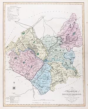
In den WarenkorbAntique map in original color from 1833. Size: c. 47 x 39 cm. -- in very good condition. || Original handkolorierte Stahlstich-Karte von 1833. -- gut erhalten. || James Ebden's remarkable county maps are typical of the best maps produced for English atlases at the beginning of the 19th century. Skillfully engraved and beautifull…y hand colored, they are relatively large compared to the majority of other county maps of the early 19th century. Their size allows for a clearer, more detailed depiction of the regions. The maps show the individual counties and all their major roads. They are accompanied by a legend, further explanations of the symbols used, a mileage scale, and a description of the counties' districts and/or other territorial divisions. || Dies ist ein Original! - Kein Nachdruck! - Keine Kopie! -- This is an original! - No copy! - No reprint! Antique map in original color from 1833. Size: c. 47 x 39 cm. -- in very good condition. || Original handkolorierte Stahlstich-Karte von 1833. -- gut erhalten. || James Ebden's remarkable county maps are typical of the best maps produced for English atlases at the beginning of the 19th century. Skillfully engraved and beautifully hand colored, they are relatively large compared to the majority of other county maps of the early 19th century. Their size allows for a clearer, more detailed depiction of the regions. The maps show the individual counties and all their major roads. They are accompanied by a legend, further explanations of the symbols used, a mileage scale, and a description of the counties' districts and/or other territorial divisions. || Dies ist ein Original! - Kein Nachdruck! - Keine Kopie! -- This is an original! - No copy! - No reprint! // Wir, das Antiquariat Steffen Völkel, kaufen und verkaufen alte Bücher, Handschriften, Zeichnungen, Autographen, Grafiken und Fotografien. Wir sind stets am Ankauf von kompletten Bibliotheken, Sammlungen und Nachlässen interessiert. Sprache: Englisch.

Verlag: Nichols, Leicester 1811
- Softcover
- Erstausgabe
Anbieter: Maynard & Bradley, Leicester, Vereinigtes KönigreichMaynard & Bradley
Verkäufer/-in kontaktierenVerkäufer/-in mit 5 SternenZustand: Gebraucht - Gut
EUR 23,23
EUR 25,38 VersandVersand von Vereinigtes Königreich nach USAAnzahl: 1 verfügbar
In den WarenkorbZustand: Very Good. 1st Edition. This is an original Georgian copperplate 215 x 230 mm. engraving of a Map of Arden. Edges are very neat except four small tears along both left and right sides of paper, one going 10 mm through the plate mark and a few slight creases traveling from the bottom to the top of the paper towards the r…ight hand side. Tears all repaired with conservation tape. Within plate mark on paper sized 270 x 440 mm. Buy with confidence, support a genuine Independent Bricks & Mortar Real Bookshop and help to preserve our High streets as interesting places to shop. We are Maynard & Bradley CAMBO & PBFA(now lapsed) members here in Leicester City Centre, UK Why on Amazon do most sellers not describe their actual book? Buy with confidence and support a genuine Independent Bricks & Mortar Real Bookshop. We are Maynard & Bradley CAMBO & PBFA(now lapsed) members here in Leicester City Centre. 1811. Size: 215 x 230 mm. 1 pages. Item Type: Antique Print. Illustrator: unknown. Quantity Available: 1. Shipped Weight: Under 500 grams. Category: Geography & Maps; Lithos & Prints; Britain/UK; 19th century; Pictures of this item not already displayed here available upon request. Inventory No: 30001. Softcover (Single Sheet of thick paper). unknown (illustrator).

Sprache: Englisch
Verlag: Leicestershire Museums, Arts & Records Service 1985
- Softcover
Anbieter: WeBuyBooks, Rossendale, Vereinigtes KönigreichWeBuyBooks
Verkäufer/-in kontaktierenVerkäufer/-in mit 5 SternenZustand: Gebraucht - Gut
EUR 75,83
EUR 6,71 VersandVersand von Vereinigtes Königreich nach USAAnzahl: 1 verfügbar
Zustand: Very Good. Most items will be dispatched the same or the next working day. A copy that has been read, but is in excellent condition. Pages are intact and not marred by notes or highlighting. The spine remains undamaged.
 Weitere Bilder
Verlag: J. Robins, Albion Press, London 1819
- Softcover
- Erstausgabe
Anbieter: Maynard & Bradley, Leicester, Vereinigtes KönigreichMaynard & Bradley
Verkäufer/-in kontaktierenVerkäufer/-in mit 5 SternenZustand: Gebraucht - Befriedigend
EUR 25,61
EUR 25,38 VersandVersand von Vereinigtes Königreich nach USAAnzahl: 1 verfügbar
In den WarenkorbSoftcover. Zustand: Good. First Edition. This is an original Georgian engraved map complete with partially bound text block ,ex Dugdale's 'The New British Traveller, or Modern Panorama of England and Wales [.] Forming a Complete Survey of South Britain'. Included is the descriptive text. The map bears some light browning and wea…r along the edges, some faint damp marks and spots. Page edges are very lightly worn with tiny creases and tears, and pages bear some faint scattered foxing. A close-up photo is available by request. Why on Amazon do most sellers not describe their actual book? Buy with confidence and support a genuine Independent Bricks & Mortar Real Bookshop. We are Maynard & Bradley CAMBO & PBFA(now lapsed) members here in Leicester City Centre. Size: 220 x 270 mm. 40 pages. Item Type: Book. Quantity Available: 1. Shipped Weight: Under 500 grams. Category: Geography & Maps; Britain/UK; 19th century; Pictures of this item not already displayed here available upon request. Inventory No: 03142.
Sprache: Englisch
Verlag: Fullarton, London 1850
Anbieter: K Books Ltd ABA ILAB, York, Vereinigtes KönigreichK Books Ltd ABA ILAB
Verkäufer/-in kontaktierenVerkäufer/-in mit 5 SternenZustand: Gebraucht - Gut
EUR 35,72
EUR 22,54 VersandVersand von Vereinigtes Königreich nach USAAnzahl: 1 verfügbar
In den WarenkorbNo Binding. Zustand: Very Good. A splendid original antique hand coloured map . Mounted - matted and ready to frame . Very good condition . Shows a fine study of Leicestershire - with a coloured vignette of Belvoir Castle - very detailed colouring not contemporary but delicately and expertly executed.
Sprache: Englisch
Verlag: Dugdale, London 1843
Anbieter: K Books Ltd ABA ILAB, York, Vereinigtes KönigreichK Books Ltd ABA ILAB
Verkäufer/-in kontaktierenVerkäufer/-in mit 5 SternenZustand: Gebraucht - Gut
EUR 35,72
EUR 22,54 VersandVersand von Vereinigtes Königreich nach USAAnzahl: 1 verfügbar
In den WarenkorbNo Binding. Zustand: Very Good. LEICESTERSHIRE. .An original antique hand coloured county map. Map size approx. 10 x 8.5 in, 26 x 21 cms. Mounted and ready to frame, mount size approx. 12 x 10 in, 31 x 25 cms, very good condition. Much detail of towns, villages, Country Seats, castles, abbeys, mail coach roads, railways, polling… stations, etc. 1843 - drawn & engraved by Archer.

Verlag: ALL JIGSAW PUZZLES 2024
Anbieter: PBShop.store UK, Fairford, Vereinigtes KönigreichPBShop.store UK
Verkäufer/-in kontaktierenVerkäufer/-in mit 5 SternenZustand: Neu
EUR 24,82
EUR 5,80 VersandVersand von Vereinigtes Königreich nach USAAnzahl: 6 verfügbar
UNK. Zustand: New. New Book. Shipped from UK. Established seller since 2000.
Verlag: Ordnance Map Office Tower of London 1835
- Softcover
Anbieter: Anybook.com, Lincoln, Vereinigtes KönigreichAnybook.com
Verkäufer/-in kontaktierenVerkäufer/-in mit 5 SternenZustand: Gebraucht - Befriedigend
EUR 38,11
EUR 15,72 VersandVersand von Vereinigtes Königreich nach USAAnzahl: 1 verfügbar
In den WarenkorbZustand: Good. This is an ex-library book and may have the usual library/used-book markings inside.This book has soft covers. In good all round condition. Sheet No. 63 of a larger set. 34x26.5in. Scale: 1 inch to a statute mile. Shows Leicester, Charnwood Forest, Market Harborough, Nuneaton, Market Bosworth, Part of Derbyshire,…Ashby Woulds, Ashby de la Zouch, Atherstone and surrounding areas plus part of Avon shown in purple and blue. Dissected into 15 sections and backed with canvas. Some foxing on map and age related marks on canvas. Has marbled paper covers when folded. Please note the Image in this listing is a stock photo and may not match the covers of the actual item,250grams, ISBN.
Verlag: Published by Chapman & Hall No date 1831 1831
Anbieter: PROCTOR / THE ANTIQUE MAP & BOOKSHOP, DORCHESTER, Vereinigtes KönigreichPROCTOR / THE ANTIQUE MAP & BOOKSHOP
Verkäufer/-in kontaktierenVerkäufer/-in mit 5 SternenZustand: Gebraucht
EUR 17,86
EUR 23,12 VersandVersand von Vereinigtes Königreich nach USAAnzahl: 1 verfügbar
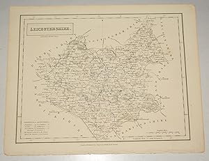
In den WarenkorbUncoloured Unmounted. In very good condition. Strong impression. Engraved surface Size 24 x 19cm.
Verlag: 1840. c. 10.25in x 10.5in (Sheet size) 1840
Anbieter: R.G. Watkins Books and Prints, Ilminster, Vereinigtes KönigreichR.G. Watkins Books and Prints
Verkäufer/-in kontaktierenVerkäufer/-in mit 5 SternenZustand: Gebraucht
EUR 11,91
EUR 32,37 VersandVersand von Vereinigtes Königreich nach USAAnzahl: 1 verfügbar
In den WarenkorbMap drawn by R. Creighton, engraved by J. & C. Walker, from Lewis's Topographical Dictionary, vertical fold, very slight foxing, some off-setting.

- Softcover
Anbieter: WorldofBooks, Goring-By-Sea, Vereinigtes KönigreichWorldofBooks
Verkäufer/-in kontaktierenVerkäufer/-in mit 5 SternenZustand: Gebraucht - Gut
EUR 115,67
EUR 6,47 VersandVersand von Vereinigtes Königreich nach USAAnzahl: 1 verfügbar
Paperback. Zustand: Very Good. The book has been read, but is in excellent condition. Pages are intact and not marred by notes or highlighting. The spine remains undamaged.

Verlag: David & Charles A facsimile of the Camden?s Britannia1695 edition Published 1971 1971
Anbieter: PROCTOR / THE ANTIQUE MAP & BOOKSHOP, DORCHESTER, Vereinigtes KönigreichPROCTOR / THE ANTIQUE MAP & BOOKSHOP
Verkäufer/-in kontaktierenVerkäufer/-in mit 5 SternenZustand: Gebraucht
EUR 23,82
EUR 23,12 VersandVersand von Vereinigtes Königreich nach USAAnzahl: 1 verfügbar
In den WarenkorbDouble page map with centre fold. In very good condition. Size 19 x 15.5 inches From the facsmile Large Paper Edition from Camden?s Britannia. Showing towns and villages and divided into Hundreds.
Sprache: Englisch
Anbieter: K Books Ltd ABA ILAB, York, Vereinigtes KönigreichK Books Ltd ABA ILAB
Verkäufer/-in kontaktierenVerkäufer/-in mit 5 SternenZustand: Gebraucht - Gut
EUR 35,72
EUR 22,54 VersandVersand von Vereinigtes Königreich nach USAAnzahl: 1 verfügbar
In den WarenkorbNo Binding. Zustand: Very Good. Antique (later) hand-coloured map. Plate size approx. 10 x 8.5 inches 24 x 21 cms. Mounted and ready to frame, mount size approx. 15 x 12 inches, 39 x 30 cms, VERY GOOD, ca 1830. Decorative and unusual. - considerable detail, market towns, villages, hamlets, woods, country houses, coaching roads,…turnpikes, etc, etc.-.

ORIGINAL ENGRAVED MAP OF Leicestershire. Engraved for LEWIS's ?Topographical Dictionary? and drawn by R. Creighton. From: ?AN ATLAS comprising Maps of the Several Counties, divided into Unions?.?.
WALKER, J. & C. / LEWIS:
Verlag: Published by S.Lewis & Co. Ca 1842. 1842
Anbieter: PROCTOR / THE ANTIQUE MAP & BOOKSHOP, DORCHESTER, Vereinigtes KönigreichPROCTOR / THE ANTIQUE MAP & BOOKSHOP
Verkäufer/-in kontaktierenVerkäufer/-in mit 5 SternenZustand: Gebraucht
EUR 30,96
EUR 23,12 VersandVersand von Vereinigtes Königreich nach USAAnzahl: 1 verfügbar
In den WarenkorbSize of engraved surface: 26 cm x 26 cm. Overall size: ca. 31 cm x 34 cm. With side fold. In good condition. A few light marks, & a couple of small nicks on edges, small tear top edge. Later Hand Colouring. The Map shows the principal roads, rivers, railways and canals. The Walker brothers were publishers and engravers.
Verlag: London
- Hardcover
Anbieter: St Marys Books And Prints, Stamford, Vereinigtes KönigreichSt Marys Books And Prints
Verkäufer/-in kontaktierenVerkäufer/-in mit 4 SternenZustand: Gebraucht
EUR 53,59
EUR 23,87 VersandVersand von Vereinigtes Königreich nach USAAnzahl: 1 verfügbar
In den WarenkorbHardback. Original County Map of Staffordshire coloured measuring approx 25cm x 20cm inclusive of cream coloured mount 38cm x 33cm From Thomas Dugdales 1835 Curiosities of Great Britain and Ireland originally produced with a series of county maps by GCole and JRoper when it was reissued in 1843 and 1848 these maps were replaced…by those of John Archer who produced his maps from a steel engraved plate the preference of the time was copper which was to prove one of the major printing advances of the nineteenth century Overall in excellent condition. book.

Verlag: J. Throsby, UK 1791
- Softcover
Anbieter: Maynard & Bradley, Leicester, Vereinigtes KönigreichMaynard & Bradley
Verkäufer/-in kontaktierenVerkäufer/-in mit 5 SternenZustand: Gebraucht - Gut
EUR 53,53
EUR 25,38 VersandVersand von Vereinigtes Königreich nach USAAnzahl: 1 verfügbar
In den WarenkorbSoftcover. Zustand: Very Good. 1791. A clean and well-presented antique map of the Leicestershire area, charting part of the Roman road from London to Lincoln. A few very minor nicks around the outer edges of the page, but free from any major signs of wear. Why on Amazon do most sellers not describe their actual book? Buy with c…onfidence and support a genuine Independent Bricks & Mortar Real Bookshop. We are Maynard & Bradley CAMBO & PBFA(now lapsed) members here in Leicester City Centre. Size: 195 x 265 mm. 1. Item Type: Book. Quantity Available: 1. Shipped Weight: Under 500 grams. Category: Geography & Maps; Britain/UK; 18th century; Inventory No: 52941.
 Weitere Bilder
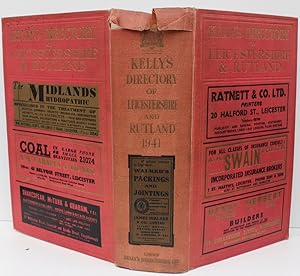
Verlag: Kelly's Directories Ltd., 1941. 1941
- Hardcover
Anbieter: Michael S. Kemp, Bookseller, Sheerness, Vereinigtes KönigreichMichael S. Kemp, Bookseller
Verkäufer/-in kontaktierenVerkäufer/-in mit 5 SternenZustand: Gebraucht
EUR 66,69
EUR 46,25 VersandVersand von Vereinigtes Königreich nach USAAnzahl: 1 verfügbar
In den WarenkorbLarge 8vo. pp. 23 [adverts], xvi, 1390; folding map loose. Original cloth torn at the top of the spine.

Verlag: T. Combe, Leicester 1802
- Karte
Anbieter: Maynard & Bradley, Leicester, Vereinigtes KönigreichMaynard & Bradley
Verkäufer/-in kontaktierenVerkäufer/-in mit 5 SternenZustand: Gebraucht - Gut
EUR 47,58
EUR 25,38 VersandVersand von Vereinigtes Königreich nach USAAnzahl: 1 verfügbar
In den WarenkorbSingle Sheet of Medium Paper. Zustand: Very Good. Edition Unstated. This is a modern Black & White copy of a scarce original copperplate engraved Town plan of Leicester. On paper sized 210 x 297 mm. Buy with confidence, support a genuine Independent Bricks & Mortar Real Bookshop and help to preserve our High streets as interesti…ng places to shop. We are Maynard & Bradley CAMBO & PBFA(now lapsed) members here in Leicester City Centre, UK Why on Amazon do most sellers not describe their actual book? Buy with confidence and support a genuine Independent Bricks & Mortar Real Bookshop. We are Maynard & Bradley CAMBO & PBFA(now lapsed) members here in Leicester City Centre. Size: 210 x 297 mm. 1 pages. Item Type: Map. Illustrator: unknown. Quantity Available: 1. Shipped Weight: Under 500 grams. Category: Geography & Maps; Lithos & Prints; Britain/UK; 19th century; Pictures of this item not already displayed here available upon request. Inventory No: 28776. unknown (illustrator).

Verlag: London, c.1720. 180 x 115mm (7 x 4½ inches). 1720
Anbieter: Tooley, Adams & Co., Wallingford, Vereinigtes KönigreichTooley, Adams & Co.
Verkäufer/-in kontaktierenVerkäufer/-in mit 4 SternenZustand: Gebraucht
EUR 28,58
EUR 42,95 VersandVersand von Vereinigtes Königreich nach USAAnzahl: 1 verfügbar
In den WarenkorbUncoloured; light age-toning to the edges of the paper, otherwise a good example. From 'Britannia Depicta or Ogilby Improv'd'.

Verlag: London, 1790-95. 265 x 325mm (10½ x 12¾ inches). 1795
- Softcover
Anbieter: Tooley, Adams & Co., Wallingford, Vereinigtes KönigreichTooley, Adams & Co.
Verkäufer/-in kontaktierenVerkäufer/-in mit 4 SternenZustand: Gebraucht
EUR 77,40
EUR 42,95 VersandVersand von Vereinigtes Königreich nach USAAnzahl: 1 verfügbar
In den WarenkorbUncoloured; light soiling and minor spotting, otherwise a good example. A rare map of the county originally published in the 'Political Magazine' from 1782-90. Engraved by John Lodge, this atlas edition of 1795 has the name erased. Ink manuscript details about the county on the verso.

Verlag: London, c.1720. 180 x 115mm (7 x 4½ inches). 1720
Anbieter: Tooley, Adams & Co., Wallingford, Vereinigtes KönigreichTooley, Adams & Co.
Verkäufer/-in kontaktierenVerkäufer/-in mit 4 SternenZustand: Gebraucht
EUR 29,77
EUR 42,95 VersandVersand von Vereinigtes Königreich nach USAAnzahl: 1 verfügbar
In den WarenkorbUncoloured; light age-toning to the edges of the paper, otherwise a good example. A miniature map of the county of Warwickshire, from 'Britannia Depicta or Ogilby Improv'd', published by by John Owen and Emanuel Bowen. The verso has the road from Pembridge via Prestain and on to Montgomery.

England III. Lincolnshire, Nottinghamshire, Derbyshire, Leicestershire, Warwickshire, Northhamptonshire, Huntingdonshire, Northfolk, Suffolk und Cambridgeshire. Antique Map. Grenzkolorierter Original-Stahlstich von Walker bei Baldwin & Cradock 1830
John Walker; Society for the Diffusion of Useful Knowledge (ed.)
Verlag: London: Baldwin & Cradock 1830
- Erstausgabe
- Signiert
- Karte
Anbieter: historicArt Antiquariat & Kunsthandlung, Wiesbaden-Breckenheim, DeutschlandhistoricArt Antiquariat & Kunsthandlung
Verkäufer/-in kontaktierenVerkäufer/-in mit 5 SternenZustand: Gebraucht
EUR 60,00
EUR 12,00 VersandVersand von Deutschland nach USAAnzahl: 1 verfügbar
In den Warenkorb1. Original-Stahlstich von J. & C. Walker (in der Platte signiert) auf rückseitig unbedrucktem Blatt, von alter Hand grenzkoloriert, bildliche Darstellung ca. 27 x 36 cm, Blattgröße ca. 35 x 41 cm, sauber und sehr gut erhalten 2100 gr.
 Weitere Bilder
- Karte
Anbieter: Lindisfarne Prints, Shrewsbury, Vereinigtes KönigreichLindisfarne Prints
Verkäufer/-in kontaktierenVerkäufer/-in mit 5 SternenZustand: Gebraucht
EUR 29,77
EUR 12,72 VersandVersand von Vereinigtes Königreich nach USAAnzahl: 1 verfügbar
In den WarenkorbAntique MapLEICESTERSHIREby Thomas Moule.Published circa 1850.An attractive county map of Leicestershire by Thomas Moule.Moule's maps are are well known and rightly sought after for their trademark ornate decorative borders, inset engravings and artistic presentation. Moule paid as much attention to aesthetic appeal as he did to… cartographic detail.Leicestershire is embellished with heraldic devices, a reference to the hundreds and vignette engravings of Belvoir Castle, Ulvercroft Abbey, Donnington Castle & two hunting scenes.All borders are complete which is unusual for Moule's maps.Blank verso, without folds and in fine condition save for some tiny chips at the very edges. A crisp, dark impression,Measuring approx. 10.5" x 8" (270mm x 200mm) overall.Thomas Moule (1784 - 1851) is remembered as one of the most accomplished creators of maps in the 19th century.He began his working life in London as a bookseller. From when, an interest in creating and embellishing maps led him to learn and perfect his renowned decorative and detailed English county maps.The collection was published entitled, " Moule's County Maps" circa 1830. Then, established publisher and mapmaker, George Virtue re-issued the collection in two volumes in 1836 under the title: "The collected maps of Moule". The maps themselves included illustrations of noted buildings or views within the county. They were also published in " Barclay's Complete and Universal English Dictionary" , first published in 1841 and followed by several subsequent editions. The later editions have added railways where appropriate.A GENUINE ANTIQUE MAP GUARANTEED OVER 150 YEARS OLD FROM LINDISFARNE PRINTST 31 11 24.
 Weitere Bilder
Verlag: John Lane the Bodley Head 1927
- Hardcover
Anbieter: Eurobooks Ltd, Nottingham, Vereinigtes KönigreichEurobooks Ltd
Verkäufer/-in kontaktierenVerkäufer/-in mit 5 SternenZustand: Gebraucht - Befriedigend
EUR 136,94
EUR 40,46 VersandVersand von Vereinigtes Königreich nach USAAnzahl: 1 verfügbar
In den WarenkorbHardcover. Zustand: Good. First. This sale is for two books by Simpson, Chas. W. Both 1927 First Editions. Illustrated. From The Wakely Collection - The property of the late Dr Peter Wakely, his plate to the inside front cover.Both in good condition Foxing to pages, shelf wear, discoloration to covers. 1. The Harboro' country /…by Charles Simpson; with 24 illustrations in colour and 52 in black and white by the author, and an introduction by Lord Stalbridge, joint Master of the Fernie Hunt. Map no chips or tears, near perfect. 2.1926, Leicestershire & Its Hunts: The Quorn, The Cottesmore, & The Belvoir. Book is in good condition wtih Dust Jacket poor lost to the spine chips and tears around, Inv U519.


