
Gesamtpreis (1 Artikel Artikel):
Versandziel:

map holy land divided tribes (5 Ergebnisse)
Direkt zu den wichtigsten Suchergebnissen
Suchfilter
Produktart
- Alle Product Types
- Bücher (3)
- Magazine & Zeitschriften (Keine weiteren Ergebnisse entsprechen dieser Verfeinerung)
- Comics (Keine weiteren Ergebnisse entsprechen dieser Verfeinerung)
- Noten (Keine weiteren Ergebnisse entsprechen dieser Verfeinerung)
- Kunst, Grafik & Poster (1)
- Fotografien (Keine weiteren Ergebnisse entsprechen dieser Verfeinerung)
- Karten (1)
- Manuskripte & Papierantiquitäten (Keine weiteren Ergebnisse entsprechen dieser Verfeinerung)
Zustand Mehr dazu
- Neu (Keine weiteren Ergebnisse entsprechen dieser Verfeinerung)
- Wie Neu, Sehr Gut oder Gut Bis Sehr Gut (Keine weiteren Ergebnisse entsprechen dieser Verfeinerung)
- Gut oder Befriedigend (2)
- Ausreichend oder Schlecht (Keine weiteren Ergebnisse entsprechen dieser Verfeinerung)
- Wie beschrieben (3)
Einband
- alle Einbände
- Hardcover (Keine weiteren Ergebnisse entsprechen dieser Verfeinerung)
- Softcover (Keine weiteren Ergebnisse entsprechen dieser Verfeinerung)
Weitere Eigenschaften
- Erstausgabe (Keine weiteren Ergebnisse entsprechen dieser Verfeinerung)
- Signiert (Keine weiteren Ergebnisse entsprechen dieser Verfeinerung)
- Schutzumschlag (Keine weiteren Ergebnisse entsprechen dieser Verfeinerung)
- Angebotsfoto (5)
Sprache (1)
Preis
- Beliebiger Preis
- Weniger als EUR 20 (Keine weiteren Ergebnisse entsprechen dieser Verfeinerung)
- EUR 20 bis EUR 45 (Keine weiteren Ergebnisse entsprechen dieser Verfeinerung)
- Mehr als EUR 45
Gratisversand
- Kostenloser Versand nach USA (Keine weiteren Ergebnisse entsprechen dieser Verfeinerung)
Land des Verkäufers
Verkäuferbewertung
-
A Map of the Holy Land Divided into the XII Tribes of Israel
Verlag: W.Rayner, London, 1737
Anbieter: Angelika C. J. Friebe Ltd. - MapWoman, Dorking, Vereinigtes Königreich
Verkäuferbewertung 5 von 5 Sternen

Karte
EUR 178,69
EUR 23,13 Versand
Versand von Vereinigtes Königreich nach USAAnzahl: 1 verfügbar
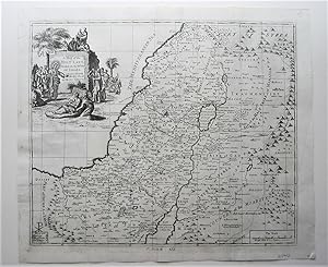
In den WarenkorbNo Binding. Zustand: Good. copper engraved map; overall 39 x 46 cm; plate 37 x 42 cm. folds as issued; additional creases; some stains; some marginal repairs; o/w g cond. An attractive map of the Holy Land, with a decorative cartouche and a scale of miles. Published in 'The Compleat History of the New and Old Testament:'.
-

A map of the Holy Land divided into the XII Tribes of Israel wherein is exactly mark'd ye travels of Iesus Christ. First edition of the map.
Verlag: London : printed for J Senex at the Globe in Salisbury Court, and W. Taylor at the Ship in Pater-Noster-Row. 1716, 1716
Anbieter: Wittenborn Art Books, San Francisco, CA, USA
Verkäuferbewertung 5 von 5 Sternen
Kunst / Grafik / Poster
Zustand: Good. Engraverd map , Handcolored. Centerfold, as issued. 42/5 x 53cm. Old laid paper, watermarked with a shield.Laurence Worms - Ash Rare Books : "Senex finished his seven-year apprenticeship in August 1702 and immediately opened his own shop: his father had died the previous year - there was probably an inheritance. It was "opposite to the South Portico of St. Clement's Church in the Strand" - this would have been more or less the view from his window. His earliest publications were modest enough, standard fare for the period, but one of these early books, seemingly his first solo publication, was a fresh edition of Caradoc's "History of Wales", published in 1702. Clavell had brought out an edition a few years earlier, but the difference was that Senex now included a little map.He and a new partner, John Maxwell, returned to retail premises at the Sign of the Globe, "going into Salisbury Court", off Fleet Street. I take this to be the Maxwell who later translated Isaac Newton's "General Scholium", published by Senex in 1715.".
-

Map of the Holy Land Divided into 12 Tribes, the Travels of Jesus Christ, 1700
Anbieter: Bartele Gallery - The Netherlands, Langweer, FRL, Niederlande
Verkäuferbewertung 5 von 5 Sternen
Antique map titled 'Het Heylige Land verdeeld in de Twaalf Stammen Israels (.)'. Decorative and detailed map of the Holy Land divided into 12 Tribes, showing the travels of Jesus Christ. Fully engraved with mountains, towns, forests and notations of important Biblical sites. Pictorial title cartouche depicting Jesus healing the sick and a scale of miles with two scholars. This map originates from 'Historie des Ouden en Nieuwen Testaments' by P. Mortier. Artists and Engravers: Pierre, or Pieter, Mortier (1661-1711) was a Dutch engraver, son of a French refugee. He was born in Leiden. In 1690 he was granted a privilege to publish French maps in Dutch lands. In 1693 he released the first and accompanying volume of the Neptune Francois. The third followed in 1700. His son, Cornelis (1699-1783), would partner with Johannes Covens I, creating one of the most important map publishing companies of the eighteenth century. Condition: Good, general age-related toning. Few repairs in lower margin, also affecting image. Please study image carefully.
-

1732 Henri Chatelain Map of the Holy Land Divided Among the Tribes of Israel
Anbieter: Bartele Gallery - The Netherlands, Langweer, FRL, Niederlande
Verkäuferbewertung 5 von 5 Sternen
Title: 1732 Henri Chatelain Map of the Holy Land Divided Among the Tribes of Israel This exquisite 18th-century map by Henri Chatelain, published in 1732, offers a detailed depiction of the Holy Land divided among the 12 Tribes of Israel. Based on the work of Nicolas Sanson, the map is enriched with colorful territorial boundaries and annotations in French, showcasing the geography and ecclesiastical organization of Palestine. The map's central focus is the division of the Holy Land, with each tribe's allocated region distinctly outlined in vibrant hand-applied colors. Surrounding the map are columns of text that list the dioceses of Palestine, providing additional insight into the ecclesiastical and administrative divisions of the time. A prominent historical note at the top provides context, making the map both a visual and educational resource. Published in Zacharie Chatelain's Atlas Historique (2nd edition), this copperplate engraving reflects the artistic and scholarly standards of early 18th-century cartography. Its meticulous detail and careful coloring make it a standout piece for collectors of Judaica, biblical cartography, or antique maps. The map also features inset notes and legends, including a scale of measurement, enhancing its functionality as a reference tool. It serves as a fascinating blend of cartographic art, historical record, and religious narrative. Condition Report: The map is in excellent condition, with vibrant original hand-coloring and clear impressions. Margins are intact, and minor age-related toning is present. No tears or repairs. Framing and Matting Tips: To emphasize its historical significance, use a double mat in neutral tones such as cream or beige, paired with a gold or dark wooden frame. UV-protective glass is recommended to preserve the delicate colors and text from fading. Adding a custom plaque or descriptive label can enhance its appeal as a display piece. Consider placing it alongside other maps or prints from the *Atlas Historique* to create a cohesive visual narrative.
-
Hand-Colored Map of the Holy Land Divided Among the Twelve Tribes, c.1720
Anbieter: Bartele Gallery - The Netherlands, Langweer, FRL, Niederlande
Verkäuferbewertung 5 von 5 Sternen
Hand-Colored Map of the Holy Land Divided Among the Twelve Tribes, c.1720 This striking antique map, titled "Iudaea seu Palaestina ob Sacratissima Redemtoris Vestigia Hodie Dicta Terra Sancta Prout olim in Deodecim Tribus Divisa Separatis ab Invicem Regnis Iuda et Israel", was created circa 1720 by Johann Baptist Homann, one of the most prominent German mapmakers of the early 18th century. The map offers a detailed and vivid depiction of the Holy Land, meticulously divided according to the twelve tribes of Israel. Covering the region from Sidon in the north to the desert of Sirbonis in the south, the map is based on earlier cartographic work by Guillaume Sanson. It includes notable geographic elements such as the Kishon River, which is curiously depicted as linking the Mediterranean Sea with the Sea of Galilee?an imaginative interpretation typical of early biblical cartography. Homann's engraving is visually enriched by two highly decorative vignettes. In the upper left, a dramatic scene shows Moses on Mount Sinai receiving the Ten Commandments amidst clouds and divine lightning. In the lower right corner, an inset map traces the route of the Exodus and Forty Years in the Wilderness. This inset is framed by figures of Moses, Aaron, and two of the twelve spies carrying a large cluster of grapes?symbolizing the bounty of the Promised Land. The map's original color remains within the main body, delineating the tribal territories in a pastel palette of pinks, yellows, and greens. The cartouches and vignette scenes feature later hand-coloring that adds vivid contrast to the composition. The typography and Latin place names further emphasize the scholarly and theological intent behind this historical map. Homann's works are prized for their decorative appeal and rich symbolism, making this map a compelling piece for collectors of biblical history, Judaica, or antique cartography. Condition Report: A strong, dark impression with original hand coloring in the main map and later enhancement in the cartouches. Minor toning and light soiling along the centerfold, with approximately a dozen small wormhole tracks scattered in the image area. Pencil graticule grid added by a previous owner. Paper generally strong and stable. Framing Tips: This map would benefit from an elegant gold or walnut-colored frame to enhance the 18th-century aesthetic. Use an off-white or cream archival mat to highlight the pastel hand coloring. Consider a museum-grade UV protective glass to preserve the pigments and prevent further toning. Technique: Engraving with hand color Maker: Johann Baptist Homann, Nuremberg, circa 1720.
