Gesamtpreis (1 Artikel Artikel):
Versandziel:

map england wales showing railways (9 Ergebnisse)
Direkt zu den wichtigsten Suchergebnissen
Suchfilter
Produktart
- Alle Product Types
- Bücher (7)
- Magazine & Zeitschriften (Keine weiteren Ergebnisse entsprechen dieser Verfeinerung)
- Comics (Keine weiteren Ergebnisse entsprechen dieser Verfeinerung)
- Noten (Keine weiteren Ergebnisse entsprechen dieser Verfeinerung)
- Kunst, Grafik & Poster (Keine weiteren Ergebnisse entsprechen dieser Verfeinerung)
- Fotografien (Keine weiteren Ergebnisse entsprechen dieser Verfeinerung)
- Karten (2)
- Manuskripte & Papierantiquitäten (Keine weiteren Ergebnisse entsprechen dieser Verfeinerung)
Zustand Mehr dazu
- Neu (Keine weiteren Ergebnisse entsprechen dieser Verfeinerung)
- Wie Neu, Sehr Gut oder Gut Bis Sehr Gut (1)
- Gut oder Befriedigend (2)
- Ausreichend oder Schlecht (1)
- Wie beschrieben (5)
Einband
Weitere Eigenschaften
- Erstausgabe (Keine weiteren Ergebnisse entsprechen dieser Verfeinerung)
- Signiert (Keine weiteren Ergebnisse entsprechen dieser Verfeinerung)
- Schutzumschlag (Keine weiteren Ergebnisse entsprechen dieser Verfeinerung)
- Angebotsfoto (7)
Sprache (2)
Gratisversand
- Kostenloser Versand nach USA (Keine weiteren Ergebnisse entsprechen dieser Verfeinerung)
Land des Verkäufers
Verkäuferbewertung
-

(Bacon's) Map of England & Wales [showing Railways, Roads, and Distances. 2 colored maps, bound in red original cloth with gilt printed title cover: Inside left: North Sheet - right: South Sheet. (internally almost fine containing 2 maps 40 x 25", 8 miles/inch (North and South sheets). Coloured, linen backed with separate map sections inset map showing "Main Roads out of London". + Railways ). Each map mounted/foulded, each map size 72x100cm]
Verlag: The Chart Publishing Company / G. W. Bacon and Co, 1930
Anbieter: G. & J. CHESTERS, TAMWORTH, Vereinigtes Königreich
Verkäuferbewertung 5 von 5 Sternen

EUR 6,03
Währung umrechnenEUR 9,19 für den Versand von Vereinigtes Königreich nach USAAnzahl: 1 verfügbar
In den WarenkorbHardcover. Zustand: Very Good. Map of England & Wales showing Railways, Roads, and Distances. 2 coloured maps, bound in red original cloth with gilt printed title cover: Inside left: North Sheet & right: South Sheet. Maps in Very Good condition. Undated so circa 1930.
-
Bacon's Cycling and Motoring Map of England & Wales. Showing Allmain Roads, Railways and Distances from London
Verlag: G W Bacon & Co Ltd, London, 1111
Anbieter: Victoria Bookshop, BERE ALSTON, DEVON, Vereinigtes Königreich
Verkäuferbewertung 5 von 5 Sternen
EUR 19,71
Währung umrechnenEUR 11,32 für den Versand von Vereinigtes Königreich nach USAAnzahl: 1 verfügbar
In den WarenkorbPaperback. Zustand: Fair. First. 16mo. A clear reading copy. Undated map - po inscription dated 1911. Red cloth cover, paper foldout map (approx A2) - clearly readable but with some easily repairable tearing along map folds. Immediate despatch from the UK. Book.
-

BACON'S MOTOR ROAD MAP, NORTH SHEET, ENGLAND AND WALES, Showing Roads, Railways and Distances. Scale: Eight Miles to One Inch.
Verlag: G W Bacon
Anbieter: Chaucer Bookshop ABA ILAB, Canterbury, Vereinigtes Königreich
Verkäuferbewertung 5 von 5 Sternen
Karte
EUR 16,57
Währung umrechnenEUR 28,73 für den Versand von Vereinigtes Königreich nach USAAnzahl: 1 verfügbar
In den WarenkorbUndated but c. mid 1930s. Map, on cloth, opening to 1m x 630 mm, in stiff grey paper covers. A few light handling marks to covers, paper slightly lifting from inside of spine, otherwise V. Good. (202 BOX 4) PLEASE NOTE: Buyer is responsible for any additional duties, taxes, or fees required by recipient's country.** Pictures available upon request.** Visit our homepage for our shop opening hours. Over 20,000 books in stock - come and browse. PayPal, credit and most debit cards welcome. Books posted worldwide. For any queries please contact us direct.
-
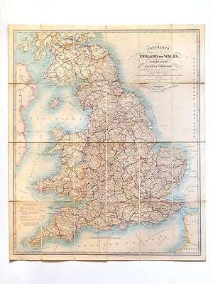
Cruchley's Reduction of his Large Map of England and Wales with Part of Scotland ; Showing all the Railways & Turnpike Roads with the Great Rivers and the course of the different Navigable Canals : The Market and Borough Towns and principal places adjoining the Road
Verlag: G. F. Cruchley, 1852
Sprache: Englisch
Anbieter: Librairie du Cardinal, GRADIGNAN, Frankreich
Verkäuferbewertung 5 von 5 Sternen
Karte
EUR 395,00
Währung umrechnenEUR 25,00 für den Versand von Frankreich nach USAAnzahl: 1 verfügbar
In den Warenkorbrigide. Zustand: Bon. Colored folding map, mounted on linen, G. F. Cruchley, 81 Fleet Street, London, s.d. [ circa 1850-1860 ], 79 x 66,5 cm. Full title : Cruchley's Reduction of his Large Map of England and Wales with Part of Scotland ; Showing all the Railways & Turnpike Roads with the Great Rivers and the course of the different Navigable Canals : The Market and Borough Towns and principal places adjoining the Road ; to which is added the distance from one market town to another, with the exact admeasurement prefixed to each from the metropolis. Nice map in its original colors (slight browning on foldings, otherwise a charming map). Langue: Anglais.
-

Map of England and Wales Showing Railways, Roads and Distances
Verlag: Published by The Chart Publishing Company, 7 St. John Street, Oxford circa . 1880., 1880
Anbieter: Little Stour Books PBFA Member, Canterbury, Vereinigtes Königreich
Verbandsmitglied: PBFA
Verkäuferbewertung 5 von 5 Sternen
EUR 59,18
Währung umrechnenEUR 22,98 für den Versand von Vereinigtes Königreich nach USAAnzahl: 1 verfügbar
In den WarenkorbHard back binding in publisher's original camel brown cloth covers, gilt title to the upper panel. Scale 8 miles to 1 inch. Code to bottom left hand corner of each map G 1071. 8vo. 10'' x 7''. Two linen backed 18 section colour maps, one to each side of the book when opened, North Sheet and South Sheet. Each map measuring 40'' x 29'' and 40'' x 25'' when opened. In Very Good clean condition with just a little fraying of the cloth the the spine ends of the book, priced 45/-. Member of the P.B.F.A. CARTOGRAPHY, MAPS, PLANS.
-
Map of England and Wales Showing Railways, Roads, and Distances. North & South.
Verlag: The Chart Publishing Company, Oxford (n.d.). ca. 1920 (Copyright K.2474), 1920
Anbieter: PROCTOR / THE ANTIQUE MAP & BOOKSHOP, DORCHESTER, Vereinigtes Königreich
Verbandsmitglied: PBFA
Verkäuferbewertung 5 von 5 Sternen
EUR 49,71
Währung umrechnenEUR 22,98 für den Versand von Vereinigtes Königreich nach USAAnzahl: 1 verfügbar
In den WarenkorbBound in red cloth hardback boards 10 x 7 inches. With gilt lettering to front. Two large maps, dissected and mounted on linen (each map has 18 sections). Sizes of each map: North; 40 x 25 Ins. (101 x 64cm), South; 40 x 29 Ins. (101 x 74cm). In very good condition. Cover has some handling marks and minor rubbing to corners, minor stain to rear. Maps are in very good condition, some minor marks/minor soiling to areas of English Channel on South Section, else maps both clean and bright. Very little or tanning or spots. The linen verso of one map is clean. Some minor tanning to paper inners on verso of linen, a couple of neat pencil notes to this part on South Section. Else a very good clean and tight copy. Fully coloured. Railways Abbreviations, Inset Map on North Section ?Main Roads Out of London?, Table of Distances on South Section.
-
Scarborough's Map of England and Wales, Showing Geographical Counties and Boroughs, railways, steamship lines.
Verlag: The Scarborough Company. [c.1903?], 1903
Anbieter: Jarndyce, The 19th Century Booksellers, London, Vereinigtes Königreich
Verbandsmitglied: ABA ILAB PBFA
Verkäuferbewertung 5 von 5 Sternen
EUR 163,34
Währung umrechnenEUR 40,22 für den Versand von Vereinigtes Königreich nach USAAnzahl: 1 verfügbar
In den WarenkorbColour map in sections, 106 x 93cm, mounted on linen folding to 22 x 11.5cm. Maroon morocco covers, lettered in gilt. v.g. Price 12/-. Oxford, Durham, NLW and Chetham's only on Copac. The scale is 10 inches to the mile; an index to the left of the map lists 'Sanitary Districts' with populations according to the 1901 census. PLEASE NOTE: For customers within the UK this item is subject to VAT.
-
The Imperial Map Of England And Wales According To The Ordnance Survey, With The Latest Additions; Showing Clearly Every Feature Of The Country Railways And Their Stations
Verlag: A. Fullarton & Co., London
Anbieter: St Marys Books And Prints, Stamford, Vereinigtes Königreich
Verkäuferbewertung 4 von 5 Sternen

EUR 769,37
Währung umrechnenEUR 23,73 für den Versand von Vereinigtes Königreich nach USAAnzahl: 1 verfügbar
In den WarenkorbHalf Leather. Roads Canals Rivers Gentlemens Seats ampc ampc By John Bartholomew On a Scale of 4 miles to an inch No date 1866 Large Folio Size Original half leather with cloth boards with some discolouration to the boards rubbing and wear to the leather some loss to the corners and to the top and base of the spine There is some cracking to the top half of the outer hinges but the binding is still fairly tight Gilt titles to the upper board are still clean and bright The interior hinges have at one time been reinforced with brown tape There is a vertical crease to the front free endpaper and to the first blank page With 16 doublepage chromolithographic maps of which plate 16 is divided into three separate maps There is foxing throughout especially to the index although with the exception of one map the Irish Sea does not affect the rest of the maps too greatly Each map is tissueguarded although some are worn and chipped Overall a good collection of maps from John Bartholomewnbsp. book.
-

The map of England and Wales showing railways, roads, and distances
Verlag: The Chart Publishing Co. / G. W. Bacon & Co., 1920
Anbieter: Cotswold Internet Books, Cheltenham, Vereinigtes Königreich
Verkäuferbewertung 5 von 5 Sternen
EUR 53,26
Währung umrechnenEUR 15,51 für den Versand von Vereinigtes Königreich nach USAAnzahl: 1 verfügbar
In den WarenkorbCopyright code J 1563. Undated, c. 1919-1922 (references the Ministry of Transport). Scale: 1 inch = 8 miles. Red cloth hardcover folder with two folding maps - North and South Sheet - sectionalised and mounted on linen attached to inner boards. Published price 47/6. Shows the big four motorways, no mention of airports. Maps in good, clean condition. A few light spots to linen backing. Gilt lettering on front board. Several small ink stains to red cloth; corners of boards bumped; a little wear to spine foot. Used - Good. Good map in red cloth boards.