
Gesamtpreis (1 Artikel Artikel):
Versandziel:

large scale inch mile map (17 Ergebnisse)
Direkt zu den wichtigsten Suchergebnissen
Suchfilter
Produktart
- Alle Product Types
- Bücher (6)
- Magazine & Zeitschriften (Keine weiteren Ergebnisse entsprechen dieser Verfeinerung)
- Comics (Keine weiteren Ergebnisse entsprechen dieser Verfeinerung)
- Noten (Keine weiteren Ergebnisse entsprechen dieser Verfeinerung)
- Kunst, Grafik & Poster (Keine weiteren Ergebnisse entsprechen dieser Verfeinerung)
- Fotografien (Keine weiteren Ergebnisse entsprechen dieser Verfeinerung)
- Karten (11)
- Manuskripte & Papierantiquitäten (Keine weiteren Ergebnisse entsprechen dieser Verfeinerung)
Zustand Mehr dazu
- Neu (Keine weiteren Ergebnisse entsprechen dieser Verfeinerung)
- Wie Neu, Sehr Gut oder Gut Bis Sehr Gut (1)
- Gut oder Befriedigend (11)
- Ausreichend oder Schlecht (Keine weiteren Ergebnisse entsprechen dieser Verfeinerung)
- Wie beschrieben (5)
Einband
- alle Einbände
- Hardcover (Keine weiteren Ergebnisse entsprechen dieser Verfeinerung)
- Softcover (1)
Weitere Eigenschaften
- Erstausgabe (9)
- Signiert (Keine weiteren Ergebnisse entsprechen dieser Verfeinerung)
- Schutzumschlag (1)
- Angebotsfoto (16)
Sprache (2)
Gratisversand
- Kostenloser Versand nach USA (Keine weiteren Ergebnisse entsprechen dieser Verfeinerung)
Land des Verkäufers
Verkäuferbewertung
-

Ordnance Survey Map England and Wales. Large Series Sheet 125 . Scale : 1 inch to a mile Guildford and Horsham
Verlag: Ordnance Survey Office / Edward Stanford, 1914
Anbieter: Gwyn Tudur Davies, Aberystwyth, Vereinigtes Königreich
Verkäuferbewertung 5 von 5 Sternen

Karte
EUR 11,89
EUR 14,43 Versand
Versand von Vereinigtes Königreich nach USAAnzahl: 1 verfügbar
In den WarenkorbSoft cover. Zustand: Good. Zustand des Schutzumschlags: Good. 3rd Edition. 1 folded folded cloth map. Some annotations and small stain on on covers o/w the map itself is clean unmarked and in very good condition. Railways revised in 1914. e1030 / m11766.
-
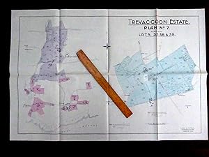
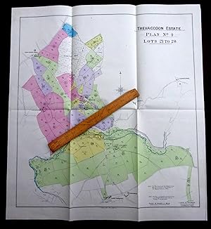
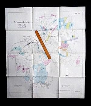
Large Scale 16 Inch to Mile Map Printed 1919 covering Properties for Sale East of St Davids as part of the Trevaccoon Estate, including CLEGYR-UCHAF, CLEGYR-ISAF, TRELERW (on Ffos Y Mynach), + Great Hook near Trefgarn Owen, Pembrokeshire.
Sprache: Englisch
Verlag: Lloyd & Thomas., Carmarthen, 1919
Anbieter: Tony Hutchinson, Seale, Vereinigtes Königreich
Verkäuferbewertung 5 von 5 Sternen
Karte Erstausgabe
EUR 28,53
EUR 10,96 Versand
Versand von Vereinigtes Königreich nach USAAnzahl: 1 verfügbar
In den WarenkorbSheet Map. Zustand: Very Good. First Edition. In very nice clean condition with just minor occasional ageing spots. Still in original folds.
-
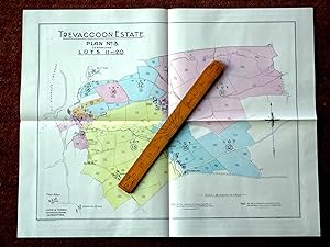
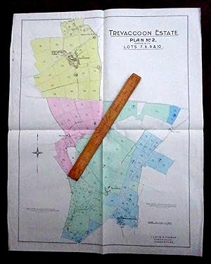
Large Scale 16 Inch to Mile Map Printed 1919 covering Properties for Sale centered on TRETIO Pembrokeshire as part of the Trevaccoon Estate, includes BEREA, TREMYNYDD FACH, PENYWAUN, LLANDIGIGE FAWR, TREF-ERFYN,
Sprache: Englisch
Verlag: Lloyd & Thomas., Carmarthen, 1919
Anbieter: Tony Hutchinson, Seale, Vereinigtes Königreich
Verkäuferbewertung 5 von 5 Sternen
Karte Erstausgabe
EUR 28,53
EUR 10,96 Versand
Versand von Vereinigtes Königreich nach USAAnzahl: 1 verfügbar
In den WarenkorbSheet Map. Zustand: Very Good. First Edition. In very nice clean condition. Still in original folds. (also includes WERN FARM (marked but not named on map).
-
Large Scale 16 Inch to Mile Map Printed 1919 covering Properties for Sale around ABEREIDDY centered on PORTHIDDY FARM ( Porth Eiddy.) as part of the Trevaccoon Estate, includes Llanvirn Farm. Pembrokeshire.
Sprache: Englisch
Verlag: Lloyd & Thomas., Carmarthen, 1919
Anbieter: Tony Hutchinson, Seale, Vereinigtes Königreich
Verkäuferbewertung 5 von 5 Sternen
Karte Erstausgabe
EUR 28,53
EUR 10,96 Versand
Versand von Vereinigtes Königreich nach USAAnzahl: 1 verfügbar
In den WarenkorbSheet Map. Zustand: Very Good. First Edition. In very nice clean condition. Still in original folds.
-
Large Scale 25 Inch to Mile Map Printed 1919 covering Properties & Land for Sale North of St Davids as part of the Trevaccoon Estate, inc Trehenlliw Farm, River Alun, Emlych, Tre-Farchan, Pont Pen-Arthur, Pen-y-bont. Pembrokeshire.
Sprache: Englisch
Verlag: Lloyd & Thomas., Carmarthen, 1919
Anbieter: Tony Hutchinson, Seale, Vereinigtes Königreich
Verkäuferbewertung 5 von 5 Sternen
Karte Erstausgabe
EUR 26,15
EUR 14,89 Versand
Versand von Vereinigtes Königreich nach USAAnzahl: 1 verfügbar
In den WarenkorbSheet Map. Zustand: Good. First Edition. In nice clean condition with just a few small spots of foxing and a light edge creasing. Still in original folds.
-
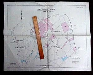
Large Scale 16 Inch to Mile Map Printed 1919 covering Properties for Sale around YSGEIFIOG Ysceifiog as part of the Trevaccoon Estate, including CAERFORIOG MILL , CARNHEDRYN BONCATH CROSS, SKYFOG, PENYWAUN, Pembrokeshire.
Sprache: Englisch
Verlag: Lloyd & Thomas., Carmarthen, 1919
Anbieter: Tony Hutchinson, Seale, Vereinigtes Königreich
Verkäuferbewertung 5 von 5 Sternen
Karte Erstausgabe
EUR 40,42
EUR 10,96 Versand
Versand von Vereinigtes Königreich nach USAAnzahl: 1 verfügbar
In den WarenkorbSheet Map. Zustand: Very Good. First Edition. In very nice clean condition with just minor occasional ageing spots. Still in original folds. Other places shown include KINGHERIOT, LLANHOWEL, LIECHFA.
-
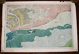
Large Hand Coloured Geological Ordnance Survey MAP SHEET 12 Basingstoke Hampshire Geological Survey of England & Wales Scale 1 inch to 1 mile.
Verlag: Geological Survey of England & Wales Colonel Colby 1860 Revised 1885, 1885
Anbieter: PROCTOR / THE ANTIQUE MAP & BOOKSHOP, DORCHESTER, Vereinigtes Königreich
Verbandsmitglied: PBFA
Verkäuferbewertung 5 von 5 Sternen
EUR 23,78
EUR 23,08 Versand
Versand von Vereinigtes Königreich nach USAAnzahl: 1 verfügbar
In den WarenkorbOriginal rolled flat map. Hand-coloured engraving With ORDNANCE SURVEY Blind Stamp top margin. Size 33.5 inches X 26.5 inches. 84cm x 66cm Ordnance survey map showing Basingstoke, Whitchurch, Andover & surrounding areas. In good condition. Some foxing & a little dusty on margins & tear on right hand side of map. A few small nicks top edge. Unfolded. It will be rolled up and posted in a poster tube.
-

Ordnance Survey Map England & Wales Large Series Scale;1 inch to a Mile
Verlag: Edward Stanford Ltd
Anbieter: Chapter 1, Johannesburg, GAU, Südafrika
Verkäuferbewertung 5 von 5 Sternen
Zustand: Good. 1912. Wraps are worn and marked.Internally clean.Well bound.Map.[RK]. Our orders are shipped using tracked courier delivery services.
-

Large Scale 16 Inch to Mile Map Printed 1919 covering Properties for Sale near WHITESAND BAY as part of the Trevaccoon Estate, including TREFELLY, TRELEDDYD-FAWR, MAESYMYNYDD, PORTHMAWR, CARNEDD GWIAN, RHOSSON, Pembrokeshire.
Sprache: Englisch
Verlag: Lloyd & Thomas., Carmarthen, 1919
Anbieter: Tony Hutchinson, Seale, Vereinigtes Königreich
Verkäuferbewertung 5 von 5 Sternen
Karte Erstausgabe
EUR 40,42
EUR 14,89 Versand
Versand von Vereinigtes Königreich nach USAAnzahl: 1 verfügbar
In den WarenkorbSheet Map. Zustand: Very Good. First Edition. In very nice clean condition with just minor occasional ageing spots. Still in original folds.
-

Large Hand Coloured Geological Ordnance Survey MAP SHEET 47 S.W Essex Geological Survey of England & Wales Scale 1 inch to 1 mile.
Verlag: Geological Survey of England & Wales 1884, 1884
Anbieter: PROCTOR / THE ANTIQUE MAP & BOOKSHOP, DORCHESTER, Vereinigtes Königreich
Verbandsmitglied: PBFA
Verkäuferbewertung 5 von 5 Sternen
EUR 26,15
EUR 23,08 Versand
Versand von Vereinigtes Königreich nach USAAnzahl: 1 verfügbar
In den WarenkorbOriginal rolled flat map. Hand-coloured engraving With ORDNANCE SURVEY Blind Stamp top margin. Size 40 inches X 26.5 inches. 100cm x 68cm Ordnance survey map showing Saffron Walden, Whitham, Royston & surrounding areas. In generally good condition. Some foxing & a little dusty on margins & right hand side. A few small nicks on edges, a little tatty top left corner. Unfolded. It will be rolled up and posted in a poster tube.
-
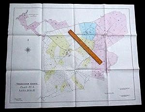
Large Scale 16 Inch to Mile Map Printed 1919 covering Properties for Sale as part of the Trevaccoon Estate, including The TREVACCOON MANSION (now Trefacwn.), TREGLEMAIS, TREFOCHLYD, TREGUY, Pembrokeshire.
Sprache: Englisch
Verlag: Lloyd & Thomas., Carmarthen, 1919
Anbieter: Tony Hutchinson, Seale, Vereinigtes Königreich
Verkäuferbewertung 5 von 5 Sternen
Karte Erstausgabe
EUR 32,70
EUR 24,24 Versand
Versand von Vereinigtes Königreich nach USAAnzahl: 1 verfügbar
In den WarenkorbSheet Map. Zustand: Very Good. First Edition. In nice clean condition with just minor edge wear. Still in original folds.
-
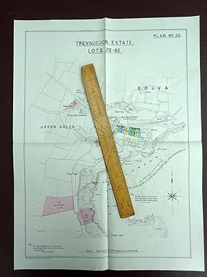
Large Scale 25 Inch to Mile Map Printed 1919 covering Properties & Land for Sale in and around SOLVA as part of the Trevaccoon Estate, Pembrokeshire. Wales.
Sprache: Englisch
Verlag: Lloyd & Thomas., Carmarthen, 1919
Anbieter: Tony Hutchinson, Seale, Vereinigtes Königreich
Verkäuferbewertung 5 von 5 Sternen
Karte Erstausgabe
EUR 38,64
EUR 24,24 Versand
Versand von Vereinigtes Königreich nach USAAnzahl: 1 verfügbar
In den WarenkorbSheet Map. Zustand: Very Good. First Edition. In nice clean condition. Still in original folds. Properties for Sale on this map (but not neccessarily named but marked in colour include MOUNT PLEASANT, WOODLAND HOUSE, BAY VIEW, THE READING ROOM, STEPS HOUSE, PROSPECT HOUSE, THE ROYAL GEORGE PUBLIC HOUSE, etc other properties named but not in the sale include The Fort, St Aidan's Church, Pant-teg, Bank House, etc.
-
Large Hand Coloured Geological Ordnance Survey MAP SHEET 8 Guildford SURREY Geological Survey of England & Wales Scale 1 inch to 1 mile.
Verlag: Geological Survey of England & Wales Colonel Colby 1816 Revised 1891, 1891
Anbieter: PROCTOR / THE ANTIQUE MAP & BOOKSHOP, DORCHESTER, Vereinigtes Königreich
Verbandsmitglied: PBFA
Verkäuferbewertung 5 von 5 Sternen
EUR 33,29
EUR 23,08 Versand
Versand von Vereinigtes Königreich nach USAAnzahl: 1 verfügbar
In den WarenkorbOriginal rolled flat map. Hand-coloured engraving With ORDNANCE SURVEY Blind Stamp top margin. Size 33.5 inches X 26 inches. 85cm x 66cm Ordnance survey map showing Guildford & surrounding areas. In good condition. Some foxing & a little dusty on margins. Margin has small tear on left, crease down right hand margin, Top edge a little nicked with one tear. MAP not affected by edge nicks etc. Unfolded. It will be rolled up and posted in a poster tube.
-
Large Scale 25 Inch to Mile Map Printed 1919 covering Properties & Land for Sale in and around St DAVIDS and down to St NON'S BAY as part of the Trevaccoon Estate, inc The Prospect Hotel, Miners Arms, Ivy house Pembrokeshire.
Sprache: Englisch
Verlag: Lloyd & Thomas., Carmarthen, 1919
Anbieter: Tony Hutchinson, Seale, Vereinigtes Königreich
Verkäuferbewertung 5 von 5 Sternen
Karte Erstausgabe
EUR 53,49
EUR 14,89 Versand
Versand von Vereinigtes Königreich nach USAAnzahl: 1 verfügbar
In den WarenkorbSheet Map. Zustand: Very Good. First Edition. In nice clean condition. Still in original folds. Properties for Sale on this map (but not neccessarily named but marked in colour include The Prospect Hotel, Miners Arms, Ivy House, Smithy in Cross Square, etc other properties named but not in the sale include PEN Y GARN, WELLFIELD COTTAGE, GROVE HOTEL, ANCHORAGE, CITY HOTEL, CATHEDRAL, BRYN-Y-GARN, ANCHORAGE, ROCK HOUSE, etc.
-

Large Hand Coloured Geological Ordnance Survey MAP SHEET 12 Basingstoke Hampshire Geological Survey of England & Wales Scale 1 inch to 1 mile.
Verlag: Geological Survey of England & Wales Colonel Colby 1860 Revised 1885, 1885
Anbieter: PROCTOR / THE ANTIQUE MAP & BOOKSHOP, DORCHESTER, Vereinigtes Königreich
Verbandsmitglied: PBFA
Verkäuferbewertung 5 von 5 Sternen
EUR 39,23
EUR 23,08 Versand
Versand von Vereinigtes Königreich nach USAAnzahl: 1 verfügbar
In den WarenkorbOriginal rolled flat map. Hand-coloured engraving With ORDNANCE SURVEY Blind Stamp top margin. Size 32.5 inches X 27.5 inches. 82cm x 70cm Ordnance survey map showing Basingstoke, Whitchurch, Andover & surrounding areas. In good condition. Some foxing & a little dusty on margins & slightly on right hand side of map. A few small nicks lower edge. Unfolded. It will be rolled up and posted in a poster tube.
-

Large Hand Coloured Geological Ordnance Survey MAP SHEET 7 LONDON including River Thames Middlesex Geological Survey of England & Wales Scale 1 inch to 1 mile.
Verlag: Geological Survey of England & Wales Colonel Colby 1822 Revised 1885, 1885
Anbieter: PROCTOR / THE ANTIQUE MAP & BOOKSHOP, DORCHESTER, Vereinigtes Königreich
Verbandsmitglied: PBFA
Verkäuferbewertung 5 von 5 Sternen
EUR 65,38
EUR 23,08 Versand
Versand von Vereinigtes Königreich nach USAAnzahl: 1 verfügbar
In den WarenkorbOriginal rolled flat map. Hand-coloured engraving With ORDNANCE SURVEY Blind Stamp top margin. Size 39.5 inches X 27 inches. 100cm x 69cm Ordnance survey map showing Uxbridge, Windsor, Watford Chelsea & surrounding areas. In generally good condition. Some foxing & a little dusty on margins & 2 tears together on top edge of map. A few small nicks on edges. Unfolded. It will be rolled up and posted in a poster tube.
-
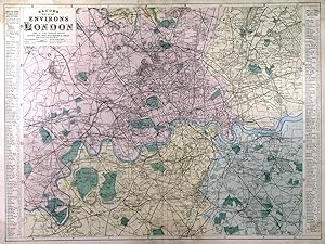
'BACON'S MAP OF THE ENVIRONS OF LONDON.'. Large double page map of the area 9 miles round London, reaching from Harrow and Hounslow in the west to Barking and Woolwich in the east, and from Edgware and Chingford in the north to Kingston and Bromley in the south. Scale: One inch to a mile.
Verlag: G. W. Bacon & Co., ca. 1879, 1879
Anbieter: Garwood & Voigt, Sevenoaks, Vereinigtes Königreich
Verkäuferbewertung 5 von 5 Sternen
Karte
EUR 285,30
EUR 34,62 Versand
Versand von Vereinigtes Königreich nach USAAnzahl: 1 verfügbar
In den WarenkorbZustand: Fine. 46x62.5cm. Full original colour. Top centre and extreme corners with occasional faint damp stains, otherwise good condition. Hyde 174.

