
Gesamtpreis (1 Artikel Artikel):
Versandziel:

iedo (25 Ergebnisse)
Direkt zu den wichtigsten Suchergebnissen
Suchfilter
Produktart
- Alle Product Types
- Bücher (6)
- Magazine & Zeitschriften (Keine weiteren Ergebnisse entsprechen dieser Verfeinerung)
- Comics (Keine weiteren Ergebnisse entsprechen dieser Verfeinerung)
- Noten (Keine weiteren Ergebnisse entsprechen dieser Verfeinerung)
- Kunst, Grafik & Poster (8)
- Fotografien (Keine weiteren Ergebnisse entsprechen dieser Verfeinerung)
- Karten (11)
- Manuskripte & Papierantiquitäten (Keine weiteren Ergebnisse entsprechen dieser Verfeinerung)
Zustand Mehr dazu
- Neu (Keine weiteren Ergebnisse entsprechen dieser Verfeinerung)
- Wie Neu, Sehr Gut oder Gut Bis Sehr Gut (3)
- Gut oder Befriedigend (Keine weiteren Ergebnisse entsprechen dieser Verfeinerung)
- Ausreichend oder Schlecht (Keine weiteren Ergebnisse entsprechen dieser Verfeinerung)
- Wie beschrieben (22)
Einband
- alle Einbände
- Hardcover (Keine weiteren Ergebnisse entsprechen dieser Verfeinerung)
- Softcover (Keine weiteren Ergebnisse entsprechen dieser Verfeinerung)
Weitere Eigenschaften
- Erstausgabe (1)
- Signiert (Keine weiteren Ergebnisse entsprechen dieser Verfeinerung)
- Schutzumschlag (Keine weiteren Ergebnisse entsprechen dieser Verfeinerung)
- Angebotsfoto (24)
Sprache (3)
Preis
- Beliebiger Preis
- Weniger als EUR 20 (Keine weiteren Ergebnisse entsprechen dieser Verfeinerung)
- EUR 20 bis EUR 45
- Mehr als EUR 45
Gratisversand
- Kostenloser Versand nach USA (Keine weiteren Ergebnisse entsprechen dieser Verfeinerung)
Land des Verkäufers
Verkäuferbewertung
-

"Iedo" - Tokyo Edo Japan Asia Asien Ansicht view
Sprache: Deutsch
Verlag: Frankfurt, 1685
Anbieter: Antiquariat Steffen Völkel GmbH, Seubersdorf, Deutschland
Verkäuferbewertung 5 von 5 Sternen

Kunst / Grafik / Poster
Original Kupferstich von Alain Manesson Mallet (1630-1706) von 1685. -- Blatt-Maße: ca. 21 x 14 cm. Mit französischem Text auf der Rückseite -- gut erhalten. || Original copper engraving by Alain Manesson Mallet (1630-1706) from 1685. -- With French text on verso. -- in good condition. // Wir, das Antiquariat Steffen Völkel, kaufen und verkaufen alte Bücher, Handschriften, Zeichnungen, Autographen, Grafiken und Fotografien. Wir sind stets am Ankauf von kompletten Bibliotheken, Sammlungen und Nachlässen interessiert. Sprache: Deutsch Gewicht in Gramm: 10.
-

"Iedo" - Tokyo Edo Japan Asia Asien Ansicht view
Sprache: Deutsch
Verlag: Frankfurt, 1719
Anbieter: Antiquariat Steffen Völkel GmbH, Seubersdorf, Deutschland
Verkäuferbewertung 5 von 5 Sternen
Kunst / Grafik / Poster
Original Kupferstich von Alain Manesson Mallet (1630-1706) von 1719. -- Blatt-Maße: ca. 20 x 15 cm. -- leicht fleckig im Außenrand, sonst gut erhalten. || Original copper engraving by Alain Manesson Mallet (1630-1706) from 1719. -- slightly stained in the margins, otherwise in very good condition. // Wir, das Antiquariat Steffen Völkel, kaufen und verkaufen alte Bücher, Handschriften, Zeichnungen, Autographen, Grafiken und Fotografien. Wir sind stets am Ankauf von kompletten Bibliotheken, Sammlungen und Nachlässen interessiert. Sprache: Deutsch Gewicht in Gramm: 10.
-

"Iedo" - Tokyo Edo Japan Asia Asien Ansicht view
Sprache: Deutsch
Verlag: Frankfurt am Main, 1685
Anbieter: Antiquariat Steffen Völkel GmbH, Seubersdorf, Deutschland
Verkäuferbewertung 5 von 5 Sternen
Kunst / Grafik / Poster
Original Kupferstich von Alain Manesson Mallet (1630-1706) von 1685. -- Blatt-Maße: ca. 21 x 15 cm. -- im oberen Außenrand teils leicht fleckig, sonst gut erhalten. || Original copper engraving by Alain Manesson Mallet (1630-1706) from 1685. -- partly slighlty stained on the upper outer margin, otherwise in good condition. // Wir, das Antiquariat Steffen Völkel, kaufen und verkaufen alte Bücher, Handschriften, Zeichnungen, Autographen, Grafiken und Fotografien. Wir sind stets am Ankauf von kompletten Bibliotheken, Sammlungen und Nachlässen interessiert. Sprache: Deutsch Gewicht in Gramm: 10.
-
![Bild des Verkäufers für [Japan - Tokyo] Palais d'Iedo. zum Verkauf von Robert Frew Ltd. ABA ILAB](https://pictures.abebooks.com/inventory/md/md32395176688.jpg)
[Japan - Tokyo] Palais d'Iedo.
Verlag: Paris ., 1683
Anbieter: Robert Frew Ltd. ABA ILAB, London, Vereinigtes Königreich
Verbandsmitglied: ABA ILAB PBFA
Verkäuferbewertung 5 von 5 Sternen
Karte
EUR 71,22
EUR 11,52 Versand
Versand von Vereinigtes Königreich nach USAAnzahl: 1 verfügbar
In den WarenkorbOriginal copper engraving (overall 21 x13.5 cm) with additional later hand colouring. An attractive print of the Imperial palace, the residency of the Japanese Emperor in Iedo [Tokyo]. Good condition. Figure XXIX.
-

Die Stadt Iedo - Iedo
Verlag: Frankfurt, 1719
Anbieter: Antiquariat Reinhold Berg eK Inh. R.Berg, Regensburg, Deutschland
Verkäuferbewertung 5 von 5 Sternen
Karte
Other. Copper engraving, uncolored as published. A bird s eye view from the town Ledo. In the foreground we can see the street which goes to the town, also we can see fields. In excellent condition. 148 by 103mm (5ľ by 4 inches). 148 by 103mm (5ľ by 4 inches).
-
Palais de Iedo
Verlag: Giappone - Japan
Anbieter: Sergio Trippini, Gavirate, VA, Italien
Verkäuferbewertung 4 von 5 Sternen

-
Iedo
Verlag: Giappone - Japan
Anbieter: Sergio Trippini, Gavirate, VA, Italien
Verkäuferbewertung 4 von 5 Sternen
-
Carte des isles du Japon esquelles est remarque la route tant par Mer que par Terre que tiennent les Hollandois pour se transporter de la ville de Nangasaqui a Iedo demeure du Roy de ces mesmes isles
Sprache: Französisch
Verlag: 1679, 1679
Anbieter: Librairie Jullien, Genčve, Schweiz
Verkäuferbewertung 5 von 5 Sternen
Pas de couverture. Zustand: Trčs bon. Carte de format env. 52 x 77 cm, en trčs bel état. Rare, on la trouve parfois en couleurs ; celle-ci est en noir et bien conservée, ŕ part une réparation sur toute la hauteur (tiers droit). On trouve également une version plus petite. Elle semble ętre issue du livre "Relation du Japon et de la cause de la persécution contre les chrestiens dans ses isles".
-

Iedo.
Verlag: Paris, 1683. 150 x 105mm (6 x 4Ľ inches)., 1683
Anbieter: Tooley, Adams & Co., Wallingford, OXON, Vereinigtes Königreich
Verkäuferbewertung 5 von 5 Sternen
EUR 77,16
EUR 42,81 Versand
Versand von Vereinigtes Königreich nach USAAnzahl: 1 verfügbar
In den WarenkorbColoured, highlighted with gum arabic; light soiling to margins, otherwise fine. An engraved view of Jedo (Tokyo) in Japan from 'Description de l'Univers", a five volume work.
-

Der Pallast zu Iedo. - Palais d Iedo.
Verlag: Frankfurt, 1719
Anbieter: Antiquariat Reinhold Berg eK Inh. R.Berg, Regensburg, Deutschland
Verkäuferbewertung 5 von 5 Sternen
Karte
Other. Copper engraving, uncolored as published. A bird s eye view from the Pallast of Iedo.?? In excellent condition. 150 by 110mm (6 by 4Ľ inches). 150 by 110mm (6 by 4Ľ inches).
-
![Bild des Verkäufers für Iedo. [Tokyo] zum Verkauf von Robert Frew Ltd. ABA ILAB](https://pictures.abebooks.com/inventory/md/md17237132638.jpg)
Iedo. [Tokyo]
Verlag: Frankfurt:, 1685
Anbieter: Robert Frew Ltd. ABA ILAB, London, Vereinigtes Königreich
Verbandsmitglied: ABA ILAB PBFA
Verkäuferbewertung 5 von 5 Sternen
Karte
EUR 148,38
EUR 11,52 Versand
Versand von Vereinigtes Königreich nach USAAnzahl: 1 verfügbar
In den WarenkorbOriginal copper engraving. 14.8 x 10.3 cm. Full later hand colour. Miniature view.
-

Die Stadt Iedo - Iedo
Verlag: Frankfurt, 1719
Anbieter: Antiquariat Reinhold Berg eK Inh. R.Berg, Regensburg, Deutschland
Verkäuferbewertung 5 von 5 Sternen
Karte
Other. Copper engraving, uncolored as published. A bird s eye view from the town Ledo. In the foreground we can see the street which goes to the town, also we can see fields. In excellent condition. 150 by 110mm (6 by 4Ľ inches). 150 by 110mm (6 by 4Ľ inches).
-
![Bild des Verkäufers für [Japan - Tokyo] Iedo. zum Verkauf von Robert Frew Ltd. ABA ILAB](https://pictures.abebooks.com/inventory/md/md32393915529.jpg)
[Japan - Tokyo] Iedo.
Verlag: Paris ., 1683
Anbieter: Robert Frew Ltd. ABA ILAB, London, Vereinigtes Königreich
Verbandsmitglied: ABA ILAB PBFA
Verkäuferbewertung 5 von 5 Sternen
Karte
EUR 207,73
EUR 11,52 Versand
Versand von Vereinigtes Königreich nach USAAnzahl: 1 verfügbar
In den WarenkorbOriginal copper engraving (overall 21 x13.5 cm) with additional later hand colouring. An attractive view of what is now Tokyo, showing a river in the foreground and buildings of the city extending to the horizon. Good condition. Figure XXVIII.
-

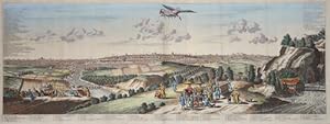
Iedo. Capitale du Japon.
Verlag: Chez Pierre van der Aa circa1720., A Leide. (Leiden)., 1720
Anbieter: Asia Bookroom ANZAAB/ILAB, Canberra, ACT, Australien
Verkäuferbewertung 5 von 5 Sternen
Engraved panorama on watermarked laid paper, 28.5 x 77.5 (including captions); 31 x 79.5 cm (sheet), title cartouche, engraved key in French and Dutch, the upper margin trimmed to the platemark, original folds, edgewear and toning, neat sealed tear to the outer edge (barely visible 5mm intrusion to the image), a very good, dark impression. Finely composed and engraved panorama of Tokyo prepared for the monumental work "Galerie Agreable du Monde" by the master Dutch publisher Pieter Van de Aa (1659-1733). The detailed key in Dutch and French, notes myriad buildings and temples on the horizon and in the foreground two processions converge: of nobles and their attendants, dancers, a trio of dogs and a priest or religious attending a suppliant. Pieter van der Aa (1659-1733) was born in Leiden, Holland and started his own book publishing business when he was only twenty-three. His prolific output of highly decorated maps and atlases culminated in his magnum opus ?Galerie Agreable du Monde? which illustrated the world known to Europeans in the early eighteenth century. Comprising 66 volumes it was the of plates published at that time, it has been estimated that only 100 copies were published.
-
Iedo
Verlag: Artist: Montanus Arnoldus ( - 1683 ) Amsterdam; issued in: London; dated: 1669, 1625
Anbieter: Antique Sommer& Sapunaru KG, München, Deutschland
Verkäuferbewertung 4 von 5 Sternen
Technic: Copper print, colorit: colored, condition: Very good, size (in cm): 29 x 77 cm, General and beautiful total view of Edo/Tokyo. From the Atlas"Gedenkwaerdige Gesantschappen der Oost-Indische Majetschappy.Kaisaren van Japan"Meurs.
-

Carte des Isles du Japon Esquelles est Remarque la Route tant par Mer que par Terre que tiennent les Hollandois pour se transporter de la Ville de Nangasaqui a Iedo demeure du Roy de ces mesmes Isles.
Verlag: c. 1679, Paris, 1679
Anbieter: Alexandre Antique Prints, Maps & Books, Toronto, ON, Kanada
Verkäuferbewertung 5 von 5 Sternen
Karte
Scarce large impressive map of Japan, engraved by J. Durant. Published in 'Recueil de plusieurs relations.' Tavernier marked several places of interest on the map, including places where "worthless" young men are sent into slave labour until recalled by their families, where silver mines can be found, and where one can find the most beautiful ladies. , Size : 520x780 (mm), 20.47x30.71 (Inches), Hand Colored Very Good; folding map flattened and laid down on acid-free tissue paper for long-term preservation. Margins extended. A short tear on the right margin, due to the attachment of the map to the book.
-
Keyser hof te Iedo. La Palais Imperial de Iedo. Ansicht des Kaiserpalastes in Tokyo.
Anbieter: Antiquariat Martin Barbian & Grund GbR, Saarbruecken, Deutschland
Verkäuferbewertung 5 von 5 Sternen
Kunst / Grafik / Poster
Kupferstich von Peter (Pieter) van der Aa, Leiden, 1727, 25x31 cm (Faltspuren, am unteren Rand etwas wellig) *Mit Legende in holländischer und französischer Sprache. *Der Kaiserpalast Tokio (japanisch Kokyo = Kaiserliche Residenz) ist die Residenz des Tenno, des japanischen Kaisers. Die kaiserliche Residenz liegt auf dem ehemaligen Gelände der Burg Edo im heutigen Stadtteil Chiyoda.
-

Teilansicht, Kaiserpalast, "Keyser hof te Iedo. La Palais Imperial de Iedo".
Anbieter: Antiquariat Clemens Paulusch GmbH, Berlin, Deutschland
Verkäuferbewertung 5 von 5 Sternen
Kunst / Grafik / Poster
Kupferstich v. Peter v. d. Aa aus Mandelslo, "Voyages .", 1727, 25 x 31,2 Krogt, Koeman's Atlantes Neerlandici, Bd. IV-A2, Abbildung 59.08. - Mit Erklärungen von 1 - 16 in holl. und franz. Sprache.
-

ROUTE d' OSACCA ŕ IEDO / ROUTE de NANGASACQUI a OSACCA - 1661-1680 (Japan, Nagasaki, Osaka, Tokyo; Arnold Montanus, Jacob Meurs) Route from Osaka to Tokyo and the route from Nagasaki to Osaka
Erscheinungsdatum: 1661
Karte
No Binding. Zustand: As New. Map of Japan made by Arnoldus Montanus. The top map shows the details of the rout from Osaka to Jedo (Tokyo). The bottom map shows the details of the route from Nagasaki to Osaka. Both maps are provided with (title)cartouches and a compass rose. A nice detail is the name 'La Mer de Corée. De Coreer Zee'. The name of this sea is still controversial. The sea is better known as the Sea of Japan. The Sea of Korea is rarely used on maps in the seventeenth century. At most four, five maps use this name, including this map of Montanus.
-
Carte des Isles du Iapon Esquelles est Remqarque la Route tant par Mer que part Terre que Tiennent les Hollandois pour se transporter de la Ville de Nagasaqui a Iedo demeure de Roy de ces mesmes Isles.
Erscheinungsdatum: 1679
Anbieter: Geographicus Rare Antique Maps, Brooklyn, NY, USA
Verbandsmitglied: ABAA ESA ILAB
Verkäuferbewertung 3 von 5 Sternen

Karte Erstausgabe
Very good. Two sheets, joined by publisher. Some wear along original fold lines, especially at fold intersections, where there is some minor verso reinforcement. Size 20.25 x 30 Inches. This is the large-format 1679 first edition of J. B. Tavernier's landmark map of Japan, eastern Korea, and the intervening sea, here named Sea of Korea (Mer de Coreer). A Closer Look The map focuses on the Japanese island Honshu and surrounding smaller islands. It includes a wealth of unique information, including cities, notes on mines, topography, and more. It further illustrates the fifty-three stations of the Great T?kaid? Road (???), a major artery between Edo (Iedo, modern-day Tokyo) and Meaco (?, Kyoto). The Great T?kaid? Road is of further significance to this map, as it illustrates the annual voyage from Nagasaki to Iedo undertaken by Dutch merchants to pay tribute to the Shogun. At the westernmost edge of the map, Korea (Coreer) is recognizable across a short strait from the 'The Kindgome of Salkock, site of the Dutch East India trading company ports at Nagasaki (Nangisaqvi) and Kagoshima (Tanegaxima)'. The sea between Japan and Korea is labeled Mer de Coreer'. Quoting Cortazzi in Isles of Gold , The map, which is on a fairly large scale, contains comments about the nature of the country. For instance, Ocasaqui (Okazaki, near Nagoya) is said to have the most beautiful women - 'C'est ou sont les plus belles femmes du pays.' Lake Bi wa is said to be where one can catch 'quantité de saumons.' Mount Fuji is described as 'Fusino-omma, montagne toujours couverte de neige.' An island, which could be Tsushima, off the coast of Kyushu is described as 'l'Isle ou on envoie la jeunesse, qui ne veut rien valoir et ou on les fait travailler par force, jusqu' a ce que leur proches les en retire' (the island where worthless youths are sent and made to work until their relations remove them)! Tavernier marked three places where there were alleged to be silver mines. Sea of Korea vs. Sea of Japan The sea between Japan and Korea, whose name, either the 'Sea of Korea,' 'East Sea,' or the 'Sea of Japan,' is here identified in favor of Korea ('Mer de Coreer'). Historically, Korea has used the term 'East Sea' since 59 B.C., and many books published before the Japanese annexed Korea make references to the 'East Sea' or 'Sea of Korea.' Over the centuries, neighboring and Western countries have identified Korea's East Sea using various terms. The St. Petersburg Academy of Sciences referred to the East Sea as 'Koreiskoe Mope' or 'Sea of Korea' in their 1745 map of Asia. Other seventeenth and 18th-century Russian maps alternate between 'The Sea of Korea' and 'The Eastern Ocean.' The 18th-century Russian and French explorers Adam Johan von Krusenstern and La Perouse called it the 'Sea of Japan,' a term that became popular worldwide. Nonetheless, the last official Russian map names the East Sea the 'Sea of Korea.' The name is currently still a matter of historical and political dispute between the countries. Publication History and Census This map was engraved by Jean-Louis Durant and published c. 1679 for the rare first edition of J. B. Tavernier's Recüeil de plusieurs relations et traitez singuliers et curieux , a companion volume to Les Six Voyages . This large-format map appeared only in the first edition, with subsequent editions of the popular work featuring a significantly reduced map. We see but one instance of the separate map in OCLC, located at Yale, but about 16 instances of the complete work in the 1679 edition. References: OCLC 956971127. Lutz, W., Japan: A Cartographic Vision: European Printed Maps from the early 16th to the 19th Century, #35. Cortazzi, H., Isles of Gold: Antique Maps of Japan, pages 46-57, plate 71. Hubbard, J. C., Japoniae Insulae: The Mapping of Japan, #43.
-

Teilansicht, Palastanlage, "Der Pallast zu iedo".
Sprache: Deutsch
Anbieter: Antiquariat Clemens Paulusch GmbH, Berlin, Deutschland
Verkäuferbewertung 5 von 5 Sternen
Kunst / Grafik / Poster
Kupferstich aus Mallet, 1719, 14,5 x 10,2 (H).
-

Gesamtansicht , "Die Stadt Iedo".
Sprache: Deutsch
Anbieter: Antiquariat Clemens Paulusch GmbH, Berlin, Deutschland
Verkäuferbewertung 5 von 5 Sternen
Kunst / Grafik / Poster
Kupferstich aus Mallet, 1719, 14,7 x 10,5 (H).
-

Kupferstich- Karte, v. Hulett aus Kaempfer, "Mappa Specialis Itineris Terrestris a Pago Fammamatz ad Urbem Iedo .".
Sprache: Deutsch
Anbieter: Antiquariat Clemens Paulusch GmbH, Berlin, Deutschland
Verkäuferbewertung 5 von 5 Sternen
Karte
1777, 30 x 23,5 (H) Darstellung des Landweges von Famamatz nach Tokio ( Yedo ), vorbei am Berg Fuji.
-

Gesamtansicht , "Iedo. Capitale de Iapon".
Sprache: Deutsch
Anbieter: Antiquariat Clemens Paulusch GmbH, Berlin, Deutschland
Verkäuferbewertung 5 von 5 Sternen
Kunst / Grafik / Poster
Kupferstich ( v. 2 Platten ) v. Peter v. d. Aa aus Mandelslo, "Voyages .", 1727, 28,5 x 77 Krogt, Koeman's Atlantes Neerlandici, Bd. IV-A2, Abbildung 59.07. - Tadellos erhaltene, dek. Gesamtansicht. Oben links und rechts Erklärungen in franz. Sprache ( 1 - 62 ), unter der Ansicht noch einmal die gleichen Erklärungen in holl. Sprache. - Mit den üblichen Längsfalten.
-

IEDO
Karte
No Binding. Zustand: As New.


