Gesamtpreis (1 Artikel Artikel):
Versandziel:

half inch map england sheet (20 Ergebnisse)
Direkt zu den wichtigsten Suchergebnissen
Suchfilter
Produktart
- Alle Product Types
- Bücher (10)
- Magazine & Zeitschriften (Keine weiteren Ergebnisse entsprechen dieser Verfeinerung)
- Comics (Keine weiteren Ergebnisse entsprechen dieser Verfeinerung)
- Noten (Keine weiteren Ergebnisse entsprechen dieser Verfeinerung)
- Kunst, Grafik & Poster (Keine weiteren Ergebnisse entsprechen dieser Verfeinerung)
- Fotografien (Keine weiteren Ergebnisse entsprechen dieser Verfeinerung)
- Karten (10)
- Manuskripte & Papierantiquitäten (Keine weiteren Ergebnisse entsprechen dieser Verfeinerung)
Zustand Mehr dazu
- Neu (Keine weiteren Ergebnisse entsprechen dieser Verfeinerung)
- Wie Neu, Sehr Gut oder Gut Bis Sehr Gut (Keine weiteren Ergebnisse entsprechen dieser Verfeinerung)
- Gut oder Befriedigend (11)
- Ausreichend oder Schlecht (1)
- Wie beschrieben (8)
Einband
Weitere Eigenschaften
- Erstausgabe (2)
- Signiert (Keine weiteren Ergebnisse entsprechen dieser Verfeinerung)
- Schutzumschlag (Keine weiteren Ergebnisse entsprechen dieser Verfeinerung)
- Angebotsfoto (18)
Sprache (2)
Gratisversand
Land des Verkäufers
Verkäuferbewertung
-
The Autocar Half Inch Map of England and Wales: Sheet 32 Sussex (Bartholomews)
Sprache: Englisch
Verlag: Iliffe & Sons, United Kingdom, 1918
Anbieter: Pendleburys - the bookshop in the hills, Llanwrda, Vereinigtes Königreich
Verkäuferbewertung 5 von 5 Sternen

Karte
EUR 14,84
EUR 13,32 Versand
Versand von Vereinigtes Königreich nach USAAnzahl: 1 verfügbar
In den WarenkorbSoft cover. Zustand: Good. No Jacket. folded linen backed map, Sheet 32, covering Sussex. A good copy, no tears or markings but with foxing to the linen backing. Undated but the 2/6d price dates this copy to 1918.
-
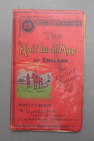
The Half Inch Map of England for Cyclists & Tourists etc - Sheet No 25 - Cheltenham & Gloucester - Cruchley's County Maps
Sprache: Englisch
Verlag: Gall & Inglis, London
Anbieter: C. Parritt, Derby, Vereinigtes Königreich
Verkäuferbewertung 5 von 5 Sternen
Karte
EUR 17,89
EUR 17,37 Versand
Versand von Vereinigtes Königreich nach USAAnzahl: 1 verfügbar
In den WarenkorbDecorative Cloth. Zustand: Fair. No Jacket. Not dated, approx 1900. Decorative red cloth boards with a little rubbing/fraying to edges, some patchy fading, minor soiling. Lithographed paper map folds out to a size of 22''x27''. Map in good condition with a few small tears. Sheet number 25 of 42 covering the whole of England & Wales. This one covers Cheltenham and Gloucester. These maps were produced as leisure maps, mainly for cyclists - there is an image of a cyclist on the front board.
-
The Half Inch Map of England for Cyclists Tourists etc. Sheet Number 17, SOMERSET / SOUTH WALES.
Sprache: Englisch
Verlag: Gall & Inglis., London, England, 1900
Anbieter: Tony Hutchinson, Seale, Vereinigtes Königreich
Verkäuferbewertung 5 von 5 Sternen
Karte
EUR 16,11
EUR 11,00 Versand
Versand von Vereinigtes Königreich nach USAAnzahl: 1 verfügbar
In den WarenkorbSoft cover. Zustand: Good. 26 x 22 inch, 36 section cloth backed folding map. Folds to 5.5 x 3 inch. Some age staining,2 small brownish stains in Bristol Channel, but no tears nor deliberate marks. Undated but probably about 1900, issued in conjunction with the 'Contour Road Books" which were first published about 1897.
-
The Half Inch Map of England for Cyclists Tourists etc. Sheet Number 19, HAMPSHIRE / BERKSHIRE.
Sprache: Englisch
Verlag: Gall & Inglis., London, England, 1900
Anbieter: Tony Hutchinson, Seale, Vereinigtes Königreich
Verkäuferbewertung 5 von 5 Sternen
Karte
EUR 17,30
EUR 11,00 Versand
Versand von Vereinigtes Königreich nach USAAnzahl: 1 verfügbar
In den WarenkorbSoft cover. Zustand: Good. 26 x 22 inch, 36 section cloth backed folding map. Folds to 5.5 x 3 inch. Some light aging as expected but no tears nor deliberate marks. Undated but probably about 1900, issued in conjunction with the 'Contour Road Books" which were first published about 1897.
-
The Half Inch Map of England for Cyclists Tourists etc. Sheet Number 1, CORNWALL.
Sprache: Englisch
Verlag: Gall & Inglis., London, England, 1900
Anbieter: Tony Hutchinson, Seale, Vereinigtes Königreich
Verkäuferbewertung 5 von 5 Sternen
Karte
EUR 17,30
EUR 11,00 Versand
Versand von Vereinigtes Königreich nach USAAnzahl: 1 verfügbar
In den WarenkorbSoft cover. Zustand: Good. 26 x 22 inch, 36 section cloth backed folding map. Folds to 5.5 x 3 inch. Some light aging as expected but no tears nor deliberate marks. Undated but probably about 1900, issued in conjunction with the 'Contour Road Books" which were first published about 1897.
-
The Half Inch Map of England for Cyclists Tourists etc. Sheet Number 13, SUSSEX.
Sprache: Englisch
Verlag: Gall & Inglis., London, England, 1900
Anbieter: Tony Hutchinson, Seale, Vereinigtes Königreich
Verkäuferbewertung 5 von 5 Sternen
Karte
EUR 17,30
EUR 11,00 Versand
Versand von Vereinigtes Königreich nach USAAnzahl: 1 verfügbar
In den WarenkorbSoft cover. Zustand: Good. 35 x 17 inch, 33 section cloth backed folding map. Folds to 5.5 x 3 inch. Some light aging as expected but no tears nor deliberate marks. Undated but probably about 1900, issued in conjunction with the 'Contour Road Books" which were first published about 1897.
-
The Half Inch Map of England for Cyclists Tourists etc. Sheet Number 18, WILTSHIRE.
Sprache: Englisch
Verlag: Gall & Inglis., London, England, 1900
Anbieter: Tony Hutchinson, Seale, Vereinigtes Königreich
Verkäuferbewertung 5 von 5 Sternen
Karte
EUR 17,30
EUR 11,00 Versand
Versand von Vereinigtes Königreich nach USAAnzahl: 1 verfügbar
In den WarenkorbSoft cover. Zustand: Good. 26 x 22 inch, 36 section cloth backed folding map. Folds to 5.5 x 3 inch. Some light aging as expected but no tears nor deliberate marks. Undated but probably about 1900, issued in conjunction with the 'Contour Road Books" which were first published about 1897.
-
The Half Inch Map of England for Cyclists Tourists etc. Sheet Number 21, KENT.
Sprache: Englisch
Verlag: Gall & Inglis., London, England, 1900
Anbieter: Tony Hutchinson, Seale, Vereinigtes Königreich
Verkäuferbewertung 5 von 5 Sternen
Karte
EUR 17,30
EUR 11,00 Versand
Versand von Vereinigtes Königreich nach USAAnzahl: 1 verfügbar
In den WarenkorbSoft cover. Zustand: Good. 26 x 22 inch, 36 section cloth backed folding map. Folds to 5.5 x 3 inch. Some light aging as expected but no tears nor deliberate marks. Undated but probably about 1900, issued in conjunction with the 'Contour Road Books" which were first published about 1897.
-
The Half Inch Map of England for Cyclists Tourists etc. Sheet Number 10, DEVON / DORSET.
Sprache: Englisch
Verlag: Gall & Inglis., London, England, 1900
Anbieter: Tony Hutchinson, Seale, Vereinigtes Königreich
Verkäuferbewertung 5 von 5 Sternen
Karte
EUR 17,30
EUR 11,00 Versand
Versand von Vereinigtes Königreich nach USAAnzahl: 1 verfügbar
In den WarenkorbSoft cover. Zustand: Good. 26 x 22 inch, 36 section cloth backed folding map. Folds to 5.5 x 3 inch. Some light aging as expected but no tears nor deliberate marks. Undated but probably about 1900, issued in conjunction with the 'Contour Road Books" which were first published about 1897.
-
The Half Inch Map of England for Cyclists Tourists etc. Sheet Number 9, DEVON.
Sprache: Englisch
Verlag: Gall & Inglis., London, England, 1900
Anbieter: Tony Hutchinson, Seale, Vereinigtes Königreich
Verkäuferbewertung 5 von 5 Sternen
Karte
EUR 17,30
EUR 11,00 Versand
Versand von Vereinigtes Königreich nach USAAnzahl: 1 verfügbar
In den WarenkorbSoft cover. Zustand: Good. 26 x 22 inch, 36 section cloth backed folding map. Folds to 5.5 x 3 inch. Some light aging as expected but no tears nor deliberate marks. Undated but probably about 1900, issued in conjunction with the 'Contour Road Books" which were first published about 1897.
-

Bartholomew's Revised ''half - inch'' Contoured Map, England Sheet 33, New Forest
Verlag: Bartholomew, John, Edinburgh, 1939
Anbieter: Bemrose Books, Otley, Vereinigtes Königreich
Verkäuferbewertung 5 von 5 Sternen
EUR 4,18
EUR 18,53 Versand
Versand von Vereinigtes Königreich nach USAAnzahl: 1 verfügbar
In den WarenkorbSoft cover. Zustand: Good. Mounted on cloth; pin prick holes to folds; one tear at edge;postage on this item will be reduced to £2.00.
-

The 'Half Inch' Map of England: Sheet Number 1
Verlag: Gall and Inglis, London, 1900
Anbieter: PsychoBabel & Skoob Books, Didcot, Vereinigtes Königreich
Verkäuferbewertung 5 von 5 Sternen
EUR 17,89
EUR 14,47 Versand
Versand von Vereinigtes Königreich nach USAAnzahl: 1 verfügbar
In den WarenkorbPaperback. Zustand: Good. Fold out map in good condition. No publication date stated; it was not published in 1900. Lightly marked and worn cover. Minor marks and age related wear to the interior, however the main content remains clear. Scale: one inch to a mile. CM. Used.
-

Bartholomew's "half-inch to mile" map of England & Wales. Sheet 1, North Northumberland
Verlag: Edinburgh: John Bartholomew & Co, 1920
Erstausgabe
First Edition. Good copy in the original stiff-card wrappers; edges somewhat nicked and dust-dulled as with age (with some minor loss to front cover). Remains quite well-preserved overall. Date is suggested. Physical description: 1 map: col. ; folded to 20 x 10 cm. Notes: Scale is 2 mile to an inch, Scale: 1:126,720. Subjects: England; Maps. Northumberland (England) Maps. 3 Kg.
-

The 'Half Inch' Map of England for Cyclists' Tourists etc. Sheet Number 13: Sussex
Verlag: Published by Gall & Inglis, London circa edition not stated. London circa 1910., 1910
Anbieter: Little Stour Books PBFA Member, Canterbury, Vereinigtes Königreich
Verbandsmitglied: PBFA
Verkäuferbewertung 5 von 5 Sternen
EUR 17,89
EUR 34,74 Versand
Versand von Vereinigtes Königreich nach USAAnzahl: 1 verfügbar
In den Warenkorb27'' x 21'' 36 section folding linen backed paper map. Roads coloured in orange. Two small tears to the folded creases down the top edge, light fraying to the front and back cover edges. Priced 1/- and 1/6 mounted on cloth. Member of the P.B.F.A. SUSSEX (Suth-Seaxe).
-

The 'Half Inch' Map of England and Wales for Cyclists' Tourists etc. Sheet Number 17 | South Wales | Somerset
Verlag: Published by Gall & Inglis, Edinburgh | 25 Paternoster Square, London circa edition not stated., 1910
Anbieter: Little Stour Books PBFA Member, Canterbury, Vereinigtes Königreich
Verbandsmitglied: PBFA
Verkäuferbewertung 5 von 5 Sternen
EUR 20,88
EUR 34,74 Versand
Versand von Vereinigtes Königreich nach USAAnzahl: 1 verfügbar
In den Warenkorb26½'' x 21½'' 36 section folding linen backed paper map. Roads coloured in orange. Priced 1/- with roads coloured and 1/6 mounted on cloth, ditto. Member of the P.B.F.A. CARTOGRAPHY, MAPS, PLANS.
-

The 'Half Inch' Map of England and Wales for Cyclists' Tourists etc. Sheet Number 26 | Buckinghamshire
Verlag: Published by Gall & Inglis, Edinburgh | 25 Paternoster Square, London circa edition not stated., 1910
Anbieter: Little Stour Books PBFA Member, Canterbury, Vereinigtes Königreich
Verbandsmitglied: PBFA
Verkäuferbewertung 5 von 5 Sternen
EUR 20,88
EUR 34,74 Versand
Versand von Vereinigtes Königreich nach USAAnzahl: 1 verfügbar
In den Warenkorb26½'' x 21½'' 36 section folding linen backed paper map. Roads coloured in orange. Priced 1/- with roads coloured and 1/6 mounted on cloth, ditto. Member of the P.B.F.A. CARTOGRAPHY, MAPS, PLANS.
-

The 'Half Inch' Map of England and Wales for Cyclists' Tourists etc. Sheet Number 30 | Montgomeryshire and Herefordshire
Verlag: Published by Gall & Inglis, Edinburgh | 25 Paternoster Square, London circa edition not stated., 1910
Anbieter: Little Stour Books PBFA Member, Canterbury, Vereinigtes Königreich
Verbandsmitglied: PBFA
Verkäuferbewertung 5 von 5 Sternen
EUR 20,88
EUR 34,74 Versand
Versand von Vereinigtes Königreich nach USAAnzahl: 1 verfügbar
In den Warenkorb26½'' x 21½'' 36 section folding linen backed paper map. Roads coloured in orange. Priced 1/- with roads coloured and 1/6 mounted on cloth, ditto. Member of the P.B.F.A. CARTOGRAPHY, MAPS, PLANS.
-

The 'Half Inch' Map of England and Wales for Cyclists' Tourists etc. Sheet Number 25 | Gloucestershire
Verlag: Published by Gall & Inglis, Edinburgh | 25 Paternoster Square, London circa edition not stated., 1910
Anbieter: Little Stour Books PBFA Member, Canterbury, Vereinigtes Königreich
Verbandsmitglied: PBFA
Verkäuferbewertung 5 von 5 Sternen
EUR 20,88
EUR 34,74 Versand
Versand von Vereinigtes Königreich nach USAAnzahl: 1 verfügbar
In den Warenkorb26½'' x 21½'' 36 section folding linen backed paper map. Roads coloured in orange. Priced 1/- with roads coloured and 1/6 mounted on cloth, ditto. Member of the P.B.F.A. CARTOGRAPHY, MAPS, PLANS.
-

The 'Half Inch' Map of England and Wales for Cyclists' Tourists etc. Sheet Number 24 | Brecknockshire and Monmouthshire
Verlag: Published by Gall & Inglis, Edinburgh | 25 Paternoster Square, London circa edition not stated., 1910
Anbieter: Little Stour Books PBFA Member, Canterbury, Vereinigtes Königreich
Verbandsmitglied: PBFA
Verkäuferbewertung 5 von 5 Sternen
EUR 20,88
EUR 34,74 Versand
Versand von Vereinigtes Königreich nach USAAnzahl: 1 verfügbar
In den Warenkorb26½'' x 21½'' 36 section folding linen backed paper map. Roads coloured in orange. Priced 1/- with roads coloured and 1/6 mounted on cloth, ditto. Member of the P.B.F.A. CARTOGRAPHY, MAPS, PLANS.
-
Bartholomew's "half-inch to mile" map of England & Wales. Sheet 30 Surrey
Verlag: London : Edward Stanford, 1920
Erstausgabe
First Edition. Very good stiff-card, linen-backed, coloured map. Edges slightly dulled and dust-toned as with age. Remains particularly well-preserved overall. Physical description: 1 map : col., mounted ; folded to 18 x 11 cm. Notes: Mounted on linen. Cover title: Bartholomew's map of England and Wales. Scale: 1: 126270. 2 miles to an inch. Subjects: Surrey (England) Maps; Surrey. 3 Kg.