Gesamtpreis (1 Artikel Artikel):
Versandziel:

government world cities (20 Ergebnisse)
Direkt zu den wichtigsten Suchergebnissen
Produktart
- Alle Produktarten
- Bücher (19)
- Magazine & Zeitschriften
- Comics
- Noten
- Kunst, Grafik & Poster
- Fotografien
- Karten (1)
-
Manuskripte &
Papierantiquitäten
Zustand
Einband
Weitere Eigenschaften
Gratisversand
Land des Verkäufers
Verkäuferbewertung
-
Government of World Cities
Verlag: John Wiley & Sons, 1995
ISBN 10: 0471949825ISBN 13: 9780471949824
Buch
Zustand: Sehr gut. Zustand: Sehr gut - Gepflegter, sauberer Zustand. Aus der Auflösung einer renommierten Bibliothek. Kann Stempel beinhalten. | Seiten: 252 | Sprache: Englisch.
-
Great Cities of the World: Their Government, Politics and Planning (Volume 2)
Verlag: George Allen & Unwin, 1972
ISBN 10: 0043500250ISBN 13: 9780043500255
Buch
Zustand: Good. Volume 2. This is an ex-library book and may have the usual library/used-book markings inside.This book has hardback covers. Clean from markings. In good all round condition. Dust jacket in good condition. Please note the Image in this listing is a stock photo and may not match the covers of the actual item,1100grams, ISBN:0043500250.
Mehr Angebote von anderen Verkäufern bei ZVAB
Gebraucht ab EUR 7,75
-
Great Cities of the World: Their Government, Politics and Planning (Volume 2)
Verlag: George Allen & Unwin, 1972
ISBN 10: 0043500242ISBN 13: 9780043500248
Buch
Zustand: Good. Volume 2. This is an ex-library book and may have the usual library/used-book markings inside.This book has hardback covers. In good all round condition. No dust jacket. Please note the Image in this listing is a stock photo and may not match the covers of the actual item,1200grams, ISBN:0043500242.
Mehr Angebote von anderen Verkäufern bei ZVAB
Gebraucht ab EUR 9,28
-

Great Cities Of The World. Their Government, Politics and Planning.
Verlag: George Allen and Unwin Ltd., London., 1957
OLeinen. Second edition - revised and enlarged. 814S. mit 88 Fotografien au8f Tafeln, mit 7 ausfaltbaren Karte / Skizzen /Grafiken. Zustand: Ausgeschiedenes Bibliotheksexemplar, Einbandkanten leicht berieben, unterer Rücken mit minimalen Kleberesten eines entfernten Aufklebers, Titelblatt mit zwei Bibliotheksstempel. Size: 8° / Gr-8°.
-

Zustand: Good. Former library book; may include library markings. Used book that is in clean, average condition without any missing pages.
-
Better Cities, Better World: A Handbook on Local Governments Self-Assessments
Verlag: The World Bank, 2019
ISBN 10: 1464813361ISBN 13: 9781464813368
Buch
Paperback. Zustand: Fine.
Mehr Angebote von anderen Verkäufern bei ZVAB
Neu ab EUR 59,92
Gebraucht ab EUR 25,90
Mehr entdecken Softcover
-
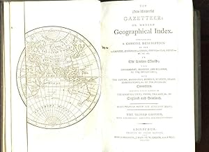
THE NEW UNIVERSAL GAZETTEER OR, MODERN GEOGRAPHICAL INDEX. CONTAINING A CONCISE DESCRIPTION OF THE EMPIRE, KINGDOMS - CITIES, TOWNS - SEAS, RIVERS - . IN KNOWN WORLD THE GOVERNMENT, MANNERS, AND RELIGION, OF THE HABITANTS; WITH THE EXTENT.
Verlag: BELL & BRADFUTE, J. DICHSON, W. CREECH AND P. HILL, 1796
Couverture rigide. Zustand: bon. R160141301: 1796. In-8. Relié plein cuir. Etat d'usage, Plats abîmés, Dos satisfaisant, Intérieur acceptable. Non paginé. Environ 400 pages. Texte en anglais. Texte sur deux colonnes. 6 cartes en noir et blanc dépliables. Pičce de titre noire et filets dorées. Epidermures sur les plats. . . . Classification Dewey : 420-Langue anglaise. Anglo-saxon.
-
The General Gazetteer or Geographical Dictionary: containing a description of the various countries, kingdoms, states, cities, towns, etc etc of the known world; an account of the government, customs, and religion of the inhabitants; the boundaries, and natural productions of each country etc etc forming a complete body of geography, physical, political, statistical, and commercial
Verlag: Berwick: Gracie, 1923
Anbieter: Antiquariat Wilder - Preise inkl. MwSt., Salzhemmendorf, Deutschland
Verbandsmitglied: GIAQ
Bewertung:

Buch
Zustand: Akzeptabel. 1st printing. 3 vols. (cplt.). IV, 712; 744; 676 pp., 25 (of 26) maps, 22 cm x 14,5 cm. contemporary half leather with red spine labels and gilt title, covers rubbed and partially bumped, one map missing, some pages and maps with foxing or brownish, binding of first vol. loosened, some pages and maps a little crinkled, otherwise solid copy. Unzugeordnet Altersfreigabe FSK ab 0 Jahre Sprache: Deutsch Gewicht in Gramm: 2900.
-
The Modern Gazetteer: being a copious Geographical Dictionary of all the nations, empires, kingdoms, republics, states, departments, provinces, counties, cities, towns, forts, oceans, seas, rivers, lakes, canals, harbours, hills, mountains, etc., of the world: describing their situation, boundaries, extent, trade, manufactures, productions, antiquities, curiosities, inhabitants, government, population, manners, laws, revolutions, religion, ancient and modern names, improvements. brought down to the present time; and illustrated with thirty-two [28] new and correct maps.
Verlag: Edinburgh printed for William Anderson Stirling, 1810
Anbieter: McLaren Books Ltd., ABA(associate), PBFA, Largs, Vereinigtes Königreich
Verbandsmitglied: ABA ILAB PBFA
Bewertung:
Hardcover. Zustand: Very Good. 2 volumes. 8vo. ppxii 952 , i 830. light browning and occasional small stains, but generally in good clean condition in a contemporary full tree calf binding. a bit musty. small catalogue number to verso of title-pages [heavy books that may require extra shipping costs for some overseas destinations. Please see our storefront page for shipping information] there are 28 maps, not the 32 called for on the title-page. But whether there ever were 32 maps included in the gazetteer is a moot point. None of the few library holdings contain detailed descriptions of the contents, and the only copy that I have been able to compare this one to is a digitised version of the University of California's copy which contains even fewer maps. The maps are generally in good condition, with one or two a little creased. The compiler of the gazetteer got his geographical priorities right; by far the largest map is that for Scotland, which is creased at the foot and has a 10cm closed tear, repaired with archival tape. These books are being sold on behalf of the Largs & District Museum & Historical Society, as instructed by the Board of Trustees.
-
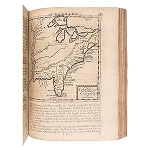
The World in Miniature: or, the Entertaining Traveller. Giving an account of every thing necessary and curious; As to Situation, Customs, Manners, Genius, Temper, Diet, Diversions, Religious and other Ceremonies; Trade, Manufactures, Arts, and Sciences; Government, Policies, Laws, Buildings; Beasts, Birds, Fishes, Plants, Drugs; Cities, Mountains, Rivers, and other Curiosities, belonging to each Country. [Vol. II] Containing America, and the Isles thereof. To which is added, an Account of England, Scotland, and Ireland; with the Isles adjacent.
Verlag: London: Printed and sold by John Torbuck, 1741
Anbieter: Forest Books, ABA-ILAB, Grantham, LINCS, Vereinigtes Königreich
Verbandsmitglied: ABA ILAB PBFA
Bewertung:
Second edition, much enlarged with "the addition of a new sett of cutts", 2 vols., 12mo (165 x 100 mm), [2], 336; 275, [21]pp., imprint date omitted in vol. I, 2 folding engraved frontispieces showing the costumes of the various countries, that to volume one with tear to fold and slightly cropped at lower margin, 10 engraved plates, woodcut head and tail pieces, a nice set in contemporary sprinkled calf, spine with five raised bands ruled in gilt, volume number in gilt to third compartments. Volume two concerns the Americas, including Peru, Mexico, Chile, Jamaica, Cuba, Virginia, Carolina, New-England and others, in addition to England, Scotland and Ireland. Provenance: Contemporary ink ownership signature of E. Vaughan 1741 to endpapers and at head of title page. Sabin 25670.
-
DARBY'S EDITION OF BROOKS' UNIVERSAL GAZETTEER; OR, A NEW GEOGRAPHICAL DICTIONARY: CONTAINING A DESCRIPTION OF THE EMPIRES, KINGDOMS, STATES, PROVINCES, CITIES, TOWNS, FORTS, SEAS, HARBOURS, RIVERS, LAKES, MOUNTAINS, CAPES, &C. IN THE KNOWN WORLD; WITH THE GOVERNMENT, CUSTOMS, AND MANNERS, OF THE INHABITANTS; THE EXTENT, BOUNDARIES, AND NATURAL PRODUCTIONS OF EACH COUNTRY; AND THE TRADE, MANUFACTURES, AND CURIOSITIES OF THE CITIES AND TOWNS. TO WHICH ARE ADDED, THE CONSTITUTION OF THE UNITED STATES, AND THE CONSTITUTIONS OF THE RESPECTIVE STATES
Verlag: Benjamin Warner, Philadelphia, 1823
Anbieter: BLACK SWAN BOOKS, INC., ABAA, ILAB, Richmond, VA, USA
Verbandsmitglied: ABAA ESA ILAB
Bewertung:
Full Leather. Zustand: Good binding. Third American Edition. An early 19c American encyclopedia, with the Declaration of Independence, Articles of Confederation, U.S. Constitution, and State Constitutions at the rear. Colored folding map of the United States of America facing the title page, with a closed tear from the top of the gutter, extending about 7 inches; also with minor loss to the far (left) edge of the map. Toning and scattered foxing to the text. Surface wear, joint wear, and small spots of staining to the binding. Full calf with a red leather label. Good binding.
-
The London General Gazetteer; or, Compendious Geographical Dictionary. Containing a Description of the Nations, Empires, Kingdoms, States, Provinces, Cities , Towns, Forts, Seas, Harbours, Rivers, Lakes, Canals, Mountains, Capes &c. of the Known World: with the Extent, Boundaries, and Natural Production of each Country; the Government, Customs, Manners, and Religion of the Inhabitants; the Trade Manufactures, and Curiosities, of the Cities and Towns, with their Longitude and Latitude, Bearing and Distance in English Miles, from Remarkable Places; and the various Historical Events, by which they have been Distinguished
Verlag: T. Tegg and Son 1837, London, 1837
Anbieter: Foster Books - Stephen Foster - ABA, ILAB, & PBFA, London, Vereinigtes Königreich
Verbandsmitglied: ABA ILAB PBFA
Bewertung:
Cloth. Zustand: Very Good. xiv, 800 pp. Rebound in a functional blue cloth with title label. Spine rubbed and a little scratched. Page edges uncut. Occasional minor spots. A complete compendium of the known world at the time, presented alphabetically with a (usually brief) description of each place. 8vo.
-
A General Gazetteer; or, Compendious Geographical Dictionary. Containing a Description of the Nations, Empires, Kingdoms, States, Provinces, Cities, Towns, Forts, Seas, Harbours, Rivers, Lakes, Canals, Mountains, Capes, &c. in the Known World: With the Extent, Boundaries and Natural Productions of each County; the Government, Customs, Manners, and Religion of the Inhabitants; the Trade, Manufactures and Curiosities, of the Cities and Towns, with their Longitude and Latitude, Bearing and Distance in English Miles, from remarkable Places; and the Various Historical Events, by which they have been distinguished. Illustrated with Maps.
Verlag: Printed for J. Bumpus, WM. Allason, J. Blacklock etc., London, 1820
Karte
, xvi 1-770 pages, contains 8 black and white folding maps Fifteenth Edition , bookplate and library stamps, corners and edges rubbed, joints repaired, covers marked slightly, foxing within, small tear to edge of frontispiece map, good condition , half calf with orange, red and blue marble paper over the covers, 5 raised bands and a gilt title on morocco label on the spine, coloured endpapers, red speckled edges , octavo, 21.5 x 14 cm Hardback ISBN:
-
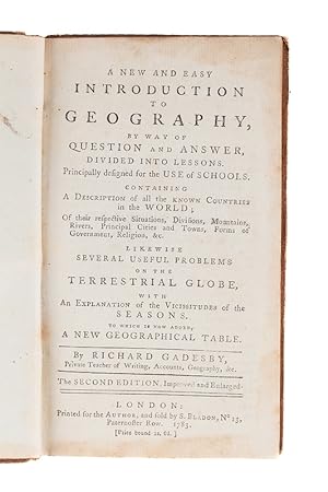
A new and easy Introduction to Geography, by Way of Question and Answer, divided into Lessons. Principally designed for the Use of Schools. Consisting of a Description of all the known Countries in the World; of their respective Situations, Divsions, Mountains; Rivers, principal Cities and Towns, Forms of Government, Religion, &c. Likewise several useful Problems of the Terrestrial Globe, with an Explanation of the Vicissitudes of the Season. To which is added a new geographical Table Second Edition, improved an enlarged. London: Printed for the Author, and sold b S. Bladon 1783
Verlag: London: Printed for the Author, and sold b S. Bladon 1783, 1783
Anbieter: Bernard Quaritch Ltd ABA ILAB, London, Vereinigtes Königreich
Verbandsmitglied: ABA ILAB PBFA
Bewertung:
Erstausgabe
12mo., pp. 191, [1, advertisement], with a folding plate showing the position of the earth and the sun at the four seasons; a very good copy in contemporary sheep, joints cracking slightly; signature of Thomas Hanmer dated 1787 on front endpaper.Second edition, revised, very rare, published following the success of the first edition (1776) and its use 'in many principal boarding schools, particularly those for young ladies'. Gadesby, 'private teacher of writing, accounts, geography, &c.', laments the neglect of geography, a very necessary science to anyone interested in the transactions of the world and the different events which happen in times of war or peace. In the edition of 1776 Lesson 66 was given to British America, covering Canada and the colonies from New York to Georgia. The present edition adds a new chapter on the United States and covers changes in possession in the West Indies resulting from the 'late wars'.BL only in ESTC. Of the first edition, ESTC records three copies; two later editions (1787 and 1792) are known in single copies. Language: English.
-
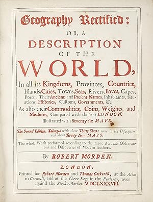
Geography Rectified: or, a Description of the World, in all its Kingdoms, Provinces, Countries, Islands, Cities, Towns, Seas, Rivers, Bays, Capes, Ports; Their Ancient and Present Names, Inhabitants, Situations, Histories, Customs, Governments.&c As also their Commodities, Coins, Weights, and Measures , Compared to those in London.
Verlag: for R. Morden and T. Cockerill, 1700
Anbieter: Bruce Marshall Rare Books, Cheltenham, Vereinigtes Königreich
Bewertung:
Buch
Hardcover. Zustand: Very Good. 4th Edition. London: printed for R. Morden and T. Cockerill, 1700, Fourth edition, thick small 4to (210 x 160mm.), Contemporary Panelled Calf, rebacked, with 78 engraved maps of the World in the text. This is an enlarged edition after the first edition that was published with 60 maps and is illustrated with 17 engraved maps of the Americas. Robert Morden was an English publisher, bookseller, map-seller, cartographer, globe and instrument maker. He worked in London at the Atlas in New Cheapside and at the Atlas in Cornhill from 1675 to 1703. His output in cartographical works was quite large and varied. It included atlases, geographical playing cards, large scale maps in a number of sheets and globes. Sabin 50535.
-
Geography Rectified: or, a Description of the World, In all its kingdoms, provinces, countries, islands, cities, towns, seas, rivers, bayes, capes, ports; their ancient and present names, inhabitants, situations, histories, customs, governments, &c. As also their commodities, coins, weights, and measures, compared with those at London. Illustrated with seventy six Maps.
Erscheinungsdatum: 1688
Anbieter: Maggs Bros. Ltd ABA, ILAB, PBFA, BA, London, Vereinigtes Königreich
Verbandsmitglied: ABA ILAB PBFA
Bewertung:
Erstausgabe
Second, enlarged, edition; quarto (200 x 155 mm); letterpress title printed in red and black, [16], 304, 321-495, 486-544, [2], 545-596pp, seventy-seven (of seventy-eight) maps, the 'catalogue' of maps, calling for seventy-six (the Armenia and Bermuda maps not called for), the Isles of Sonde map not printed on the appropriate page; text complete despite the irregular pagination. Contemporary spotted calf, covers panelled in blind, rebacked, red morocco label with gilt lettering to spine; extremities slightly worn. Manuscript on the verso of the index. London : Robert Morden & Thomas Cockerill, Robert Morden (d. 1703) was one of the most innovative of the English mapmakers and publishers in the third quarter of the seventeenth century although, as with many of his colleagues and rivals, he struggled to survive, writing in the dedication to this volume, that ?Having made many considerable Improvements and Additions to my Geography in this Second Edition, I have all the reason in the world to shelter it once more under the Patronage of your Name, whose affairs abroad have not only given you a better knowledg and experience of foreign parts; but whose encouragement and bounty, next to Divine Goodness, have only contributed to Production, which otherwise with its poor Author, must have for ever lain latent under the Horizon of unknowing Obscurity, and irresistible Poverty.? It is clear from the excuses that Morden made for this second edition, that the First Edition was not well received, and this motivated him to make considerable improvements; many of the existing plates were revised and corrected, but Morden also added twenty-five new maps, some replacements, some new drawn, to increase the maps from sixty-two to seventy-eight. The most significant are the suite of new regional maps for North America and the West Indies (Eastern North America; New England; Pennsylvania and New Jersey; Virginia; the Carolinas; Bermuda; Barbados), drawing on the most up-to-date knowledge. There are also new maps of England, Scotland, Wales, Cyprus and the Middle East. In a period when English mapmakers produced few world atlases, and even fewer survive, this is the best available to the modern collector. References: ESTC R39765; Shirley, T.MORD-2c; Worms & Baynton-Williams, on Morden.

![Bild des Verkäufers für The Modern Gazetteer: being a copious Geographical Dictionary of all the nations, empires, kingdoms, republics, states, departments, provinces, counties, cities, towns, forts, oceans, seas, rivers, lakes, canals, harbours, hills, mountains, etc., of the world: describing their situation, boundaries, extent, trade, manufactures, productions, antiquities, curiosities, inhabitants, government, population, manners, laws, revolutions, religion, ancient and modern names, improvements. brought down to the present time; and illustrated with thirty-two [28] new and correct maps. zum Verkauf von McLaren Books Ltd., ABA(associate), PBFA](https://pictures.abebooks.com/inventory/md/md31729147442.jpg)
![Bild des Verkäufers für The World in Miniature: or, the Entertaining Traveller. Giving an account of every thing necessary and curious; As to Situation, Customs, Manners, Genius, Temper, Diet, Diversions, Religious and other Ceremonies; Trade, Manufactures, Arts, and Sciences; Government, Policies, Laws, Buildings; Beasts, Birds, Fishes, Plants, Drugs; Cities, Mountains, Rivers, and other Curiosities, belonging to each Country. [Vol. II] Containing America, and the Isles thereof. To which is added, an Account of England, Scotland, and Ireland; with the Isles adjacent. zum Verkauf von Forest Books, ABA-ILAB](https://pictures.abebooks.com/inventory/md/md31013209251.jpg)