Gesamtpreis (1 Artikel Artikel):
Versandziel:

geological topographical map (16 Ergebnisse)
Direkt zu den wichtigsten Suchergebnissen
Suchfilter
Produktart
- Alle Product Types
- Bücher (13)
- Magazine & Zeitschriften (Keine weiteren Ergebnisse entsprechen dieser Verfeinerung)
- Comics (Keine weiteren Ergebnisse entsprechen dieser Verfeinerung)
- Noten (Keine weiteren Ergebnisse entsprechen dieser Verfeinerung)
- Kunst, Grafik & Poster (Keine weiteren Ergebnisse entsprechen dieser Verfeinerung)
- Fotografien (Keine weiteren Ergebnisse entsprechen dieser Verfeinerung)
- Karten (3)
- Manuskripte & Papierantiquitäten (Keine weiteren Ergebnisse entsprechen dieser Verfeinerung)
Zustand Mehr dazu
- Neu (7)
- Wie Neu, Sehr Gut oder Gut Bis Sehr Gut (Keine weiteren Ergebnisse entsprechen dieser Verfeinerung)
- Gut oder Befriedigend (4)
- Ausreichend oder Schlecht (1)
- Wie beschrieben (4)
Einband
Weitere Eigenschaften
- Erstausgabe (2)
- Signiert (Keine weiteren Ergebnisse entsprechen dieser Verfeinerung)
- Schutzumschlag (Keine weiteren Ergebnisse entsprechen dieser Verfeinerung)
- Angebotsfoto (12)
Sprache (3)
Gratisversand
Land des Verkäufers
Verkäuferbewertung
-

Contributions To The Geology, And The Physical Geography Of Mexico: Including A Geological And Topographical Map, With Profiles, Of Some Of The Principle Mining Districts
Anbieter: Ria Christie Collections, Uxbridge, Vereinigtes Königreich
Verkäuferbewertung 5 von 5 Sternen

EUR 16,59
EUR 13,80 Versand
Versand von Vereinigtes Königreich nach USAAnzahl: Mehr als 20 verfügbar
In den WarenkorbZustand: New. In.
-

Contributions To The Geology, And The Physical Geography Of Mexico: Including A Geological And Topographical Map, With Profiles, Of Some Of The Principle Mining Districts
Anbieter: Ria Christie Collections, Uxbridge, Vereinigtes Königreich
Verkäuferbewertung 5 von 5 Sternen
EUR 31,10
EUR 13,80 Versand
Versand von Vereinigtes Königreich nach USAAnzahl: Mehr als 20 verfügbar
In den WarenkorbZustand: New. In.
-

Contributions To The Geology, And The Physical Geography Of Mexico: Including A Geological And Topographical Map, With Profiles, Of Some Of The Princi
Sprache: Englisch
Verlag: Creative Media Partners, LLC Okt 2022, 2022
ISBN 10: 101654121X ISBN 13: 9781016541213
Anbieter: AHA-BUCH GmbH, Einbeck, Deutschland
Verkäuferbewertung 5 von 5 Sternen
Taschenbuch. Zustand: Neu. Neuware.
-

Shippen and Wetherill Tract. With a Geological and Topographical Map.
Verlag: Philadelphia: Sherman & Co., printers,, 1893
Anbieter: Zubal-Books, Since 1961, Cleveland, OH, USA
Verkäuferbewertung 5 von 5 Sternen
Zustand: Fair. Philadelphia: Sherman & Co., printers, 1893; 36 pp., folding map; lacks front cover of paper wrappers with back cover and map detached, a complete text but reading copy; the tract is in Schuylkill Pennesylvania and of interest for its coal beds. - If you are reading this, this item is actually (physically) in our stock and ready for shipment once ordered. We are not bookjackers. Buyer is responsible for any additional duties, taxes, or fees required by recipient's country.
-

Contributions To The Geology, And The Physical Geography Of Mexico : Including A Geological And Topographical Map, With Profiles, Of Some Of The Principle Mining Districts
Sprache: Englisch
Verlag: Creative Media Partners, LLC Okt 2022, 2022
ISBN 10: 1016528507 ISBN 13: 9781016528504
Anbieter: AHA-BUCH GmbH, Einbeck, Deutschland
Verkäuferbewertung 5 von 5 Sternen
Buch. Zustand: Neu. Neuware.
-

EUR 23,23
EUR 48,99 Versand
Versand von Deutschland nach USAAnzahl: Mehr als 20 verfügbar
In den WarenkorbKartoniert / Broschiert. Zustand: New.
-

EUR 26,25
EUR 48,99 Versand
Versand von Deutschland nach USAAnzahl: Mehr als 20 verfügbar
In den WarenkorbZustand: New.
-

EUR 37,02
EUR 48,99 Versand
Versand von Deutschland nach USAAnzahl: Mehr als 20 verfügbar
In den WarenkorbZustand: New.
-

History, Topography, and Directory of Derbyshire, comprising its history and archćology, a general view of its physical and geological features, with separate historical and topographical descriptions of each town, parish, manor, and extra-parochial liberty / by T. Bulmer & Co. ; with a map prepared expressly for the work.
Verlag: Preston: T. Snape & Co, 1895
Anbieter: Forest Books, ABA-ILAB, Grantham, LINCS, Vereinigtes Königreich
Verbandsmitglied: ABA ILAB PBFA
Verkäuferbewertung 5 von 5 Sternen
EUR 71,20
EUR 28,80 Versand
Versand von Vereinigtes Königreich nach USAAnzahl: 1 verfügbar
In den Warenkorb4to, 980, xvipp., 1 coloured folding map, orig. publishers red cloth, decorated in blind and gilt, a very good copy.
-
Geological Maps of Schuykill, Carbon, Berks and Dauphin Counties; Topographical Map of Blue Mountain at Port Clinton, in Two Sheets
Verlag: Geological Survey of Pennsylvania, Harrisburg, 1891
Anbieter: Browse Awhile Books, Tipp City, OH, USA
Verkäuferbewertung 5 von 5 Sternen
Zustand: Good. No Jacket. Six large maps in ribbon-tied boards. Maps are VG, apparently never opened. X-private library, with small label on bottom front and handstamp rear end papers. Size: Octavo.
-
1875 Original Map of G. Rohlf's Guided Expedition in the Libyan Desert 1873-1874. According to Astronomical Locations & Terrestrial Surveys by W. Jordaii, using Topographical Sketches of G. Rohlf's Edited by W. Jordan, Member of the Expedition of the Oasis of Chargeh after the Surveys of Dr. G. Schweinfurth. Geological Remarks by Dr. Zittel, Botanical Remarks by Dr. Ascherson.
Sprache: Deutsch
Verlag: Justus Perthes, Gotha, 1875
Anbieter: Independent Books, Long Beach, WA, USA
Verkäuferbewertung 2 von 5 Sternen

Karte
No Binding. Zustand: Very Good. Heinrich August Peterman (illustrator). In German: Originalkarte der G. Rohlf's Gefuhrten Expedition in die Libusche Wuste 1873-1974. Nach Astronomischen Ortsbestimmungen & Terrestrischen Aufnahmen von W. Jordaii, mit Benutzung Topographischer Skizzen von G. Rohlf's Bearbeitet von W. Jordan, Mitglied der Expedition Die Oase Chargeh nach der Aufnahme von Dr. G. Schweinfurth. Die Geologischen Bemerkungen von Dr. Zittel, die Botanischen von Dr. Ascherson. Black and white base map with oases and river basins shaded green, desert areas tinted peach, and travel routes in various colors. From "Mittheilungen aus Justus Perthes' Geographischer Anstalt uber Wichtige Neue Erforschungen auf dem Gessammtgebiete der Geographie von Dr. A. Petermann, 1875." Roughly: "Communications from Justus Perthes' Geographical Institute Concerning Important New Studies in the Whole Field of Geography by Dr. Augustus Petermann, 1875." Condition notes: 21.6" wide X 10.8" high in 6 panels (folded once in one direction and twice in the other direction), modestly toned more so at edges and folds, mild page waviness, several tiny edge chips, crease to top left margin, small closed tear to left margin, U.S. Coast Survey stamp to back.
-

Geological Map of Long & Staten Islands with the Environs of New York From the Topographical Surveys of J. Calvin Smith.
Verlag: New York, 1842
Anbieter: Raptis Rare Books, Palm Beach, FL, USA
Verkäuferbewertung 5 von 5 Sternen
Erstausgabe
Rare hand-colored example of Mather's monumental pre-Civil War wall map of Long Island, the finest and largest map of Long Island of the period. One page, two sheets joined from the topographical surveys of J. Calvin Smith, and lithographed by Endicott. Issued with Mather's 1843 Geology of New York, the map offers fine detail of the island before the intense late 19th century population growth and the completion of the Long Island Railroad (terminates here at Half Hollow Hills). The areas from Westhampton through Montauk are particularly well delineated. In very good condition with toning and closed tears. The piece measures 53 inches by 25 inches. William Williams Mather (1804â"1859) was an American geologist, educator, and mapmaker whose cartographic and scientific contributions played a notable role in the early development of geological surveying in the United States. Trained at the United States Military Academy at West Point, Mather combined rigorous scientific methodology with practical fieldwork, producing some of the most detailed geological maps of his time. As the first State Geologist of Ohio, he directed the Ohio Geological Survey (1837â"1844), creating comprehensive maps and reports that advanced understanding of the regionâs mineral resources, stratigraphy, and topography. Matherâs cartographic work reflected the growing 19th-century emphasis on systematic mapping for economic development, infrastructure planning, and scientific knowledge.
-
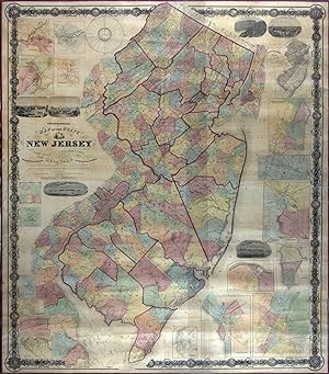
Topographical Map of the State of New Jersey Together with the Vicinities of New York and Philadelphia, and with Most of the State of Delaware from the State Geological Survey and the U.S. Coast Survey, and from Surveys by G. Morgan Hopkins, Civil Engineer
Verlag: William Kitchell, Philadelphia, 1860
Karte Erstausgabe
No binding. Zustand: Very good. First. Philadelphia: William Kitchell, 1860. Four joined sheets (67 1/2" x 58"). Scale: 2 1/2 miles to the inch. Hand-colored engraving. Competently restored with no major losses, backed on modern canvas. Kitchell's was the largest map of New Jersey published in the nineteenth century. It was an attempt to show all the roads in the state. Red lines border the twenty-one counties. Townships are tinted in pink, yellow, blue, orange, or light green. Inset around the sides are seventeen city or town maps -- Belvidere, Beverly, Bordentown, Burlington, Camden, Elizabeth, Jersey City/Hoboken, Morristown, Mount Holly, New Brunswick, Newark, Newton, Orange, Paterson, Rahway, Salem, Trenton -- and views of Camden, Delaware Water Gap, New Brunswick, Newark, Paterson, and Trenton. The presence of the branch of the Raritan and Delaware Bay Railroad through Monmouth County to Long Branch, which had just opened in June 1860, confirms the map's timeliness. Also included on this huge cartographic tapestry are a state meteorological map by Lorin Blodget, broadly defining annual rainfall and average mean temperature regions, and a time dial, "showing the time at the several County Seats when it is 12 o'clock at the Capitol." (Though American and Canadian railroads began using time zones in 1883, standard time zones were not established by Congress until 1918; before that, most places relied on "solar time," or time determined by the sun's movement.) Blodget (1823-1901) was an important figure in American climatology; his New Jersey climate map drew from his popular treatise Climatology of the United States (1857). The box at the left center of the map compares the "capacities of churches" by denomination: Methodists and Presbyterians account for more than half of the religious residents in New Jersey at this time. A geological survey of New Jersey ran 1836-1840 under the direction of Henry D. Rogers, New Jersey's first state geologist. Unfunded for fourteen years, it was resurrected by William Kitchell (1827-1861), when he was appointed state geologist and superintendent of the newly formed New Jersey Geological Survey in 1854. Funding was again stopped after two years, until the New Jersey Agricultural Society pressured the legislature in 1860, lobbying for the Survey's potential agricultural and other benefits. "An act relative to the geological survey of this state" was approved on March 15, 1860. The law allowed Kitchell the use of already-completed field maps, woodcuts, and survey apparatus -- which he was obligated to return to the state after the completion of his work -- but the resulting maps and reports from the new survey had to be published at his own cost. In addition, the law directed Kitchell to provide the state with ten copies of his new state map for the state library and state offices, to give one copy to the state agricultural society, and to deposit one in each county clerk's office for the benefit of the people. Under the direction of Kitchell, civil engineer Griffith Morgan Hopkins, Jr., compiled the latest work of the New Jersey Geological Survey and the U.S. Coast Survey. The result was this magnificent map, published privately in Philadelphia later that same year. Catalogued by Cole Edwards.
-
Asher & Adams' new topographical atlas and gazetteer of New York, comprising a topographical view of the several counties of the state, together with a railroad map, geological and meteorological maps; an alphabetical gazetteer, giving a concise description and the location of cities, villages, post offices, railroad stations, landings, &c., including a fine copper plate railroad map of the United States and territories, drawn on the polyconic projection, expressly for this work.
Verlag: Asher & Adams; Asher, Adams & Higgins, New York & Indianapolis, 1871
Anbieter: William Chrisant & Sons, ABAA, ILAB. IOBA, ABA, Ephemera Society, Fort Lauderdale, FL, USA
Verbandsmitglied: ABAA ESA ILAB
Verkäuferbewertung 5 von 5 Sternen
Zustand: Very Good. Half black cloth over brown and black pebbled cloth. Gilt particulars to front cover. Front and rear hinges beginning at head and tail. Marbled edges. Front and rear gutters separated. Vertical stains from pastedown/front endpaper to [10]. Please see image. Light moisture marks along top and bottom margins, not affecting text or images. Complete with 16 nicely hand-colored maps (4 single page, 12 double page). A nice, serviceable copy. ; Folio 13" - 23" tall; 80, [xix] pages; All shipments through USPS insured Priority Mail.
-

Topographical map of the State of New Jersey together with the vicinities of New York and Philadelphia, and with most of the state of Delaware from the State Geological Survey and the U.S. Coast Survey, and from surveys by G. Morgan Hopkins, civil engineer.
Erscheinungsdatum: 1861
Anbieter: Geographicus Rare Antique Maps, Brooklyn, NY, USA
Verbandsmitglied: ABAA ESA ILAB
Verkäuferbewertung 4 von 5 Sternen

Karte
Very good. Professionally devarnished with fresh linen backing. Size 69.5 x 58 Inches. Magnificently detailed, visually stunning, and monumentally proportioned, this is William Kitchell's seminal 1861 wall map of New Jersey. This is the largest and most detailed map of New Jersey printed in the 19th century. A Closer Look This map covers the entire state of New Jersey as well as the Delaware Bay and adjacent parts of New York, Pennsylvania (particularly Philadelphia), and Delaware. Breathtaking detail throughout. The cartographers attempted to identify every road, hill, farm, hotel, post office, river, creek, swamp, store, distillery, and nearly every non-urban building in the state. The rivers, bays, and coastlines, especially around New York Harbor and the Delaware Bay, feature countless depth soundings and other nautical references no doubt derived from the work of the U.S. Coast Survey. The whole is surrounded by a grapevine-style border further embellished with floral motif decorative medallions. The Insets In those large cities where marking individual buildings proved impossible, detailed insets are presented. The map features 17, from upper right: Paterson, Belvidere, Rahway, Morristown, Jersey City and Hoboken, Orange, Elizabeth, New Brunswick, Camden, Bordentown, Trenton, Newark, Salem, Burlington, Beverly, Newton, and Mount Holly. Additionally, there are several vignette views illustrating New Brunswick, Newark, the Delaware Water Gap, Paterson, Trenton, and Camden. Sources and History Cartographically this map is derived from the earlier work of the State Geological Survey (from work commenced in 1836 under Henry Darwin Rogers), the U.S. Coast Survey (particularly for the Delaware Bay, New York Harbor, the New Jersey coastline, and in various river ways), and further survey work completed by the civil engineer G. Morgan Hopkins under the direction of William Kitchell, superintendent of the Geological Survey of New Jersey. Work on this map began by order of the legislature in 1854 when William Kitchell was installed as State Geologist. Kitchell began compiling the map with the assistance of his staff, which included George H. Cook (assistant Geologist), Henry Wurtz (Chemist and Mineralogist), and Egbert Viele (Topographical engineer). Two years later, in 1856, the New Jersey legislature, citing financial difficulties, suspended funding for the map and abolished the office of state geologist. Over the subsequent four years, Kitchell lobbied furiously for reinstatement and, in 1860, was granted permission to access the 'apparatus and materials belonging to the state survey' to, at his own expense, complete his grand map. The result, privately published later that year, is this awesome production, a landmark in the mapping of New Jersey and a significant advancement over the 1828 Gordon map. Publication History and Census This map was first published in 1860 by H. G. Bond and William Kitchell. It is based on surveys compiled by Kitchell and G. M. Hopkins. The present example is the 1861 second edition. This map is scarce. The OCLC identifies two examples in the collections of Princeton University and the University of Massachusetts, Amherst. We have further identified examples at the New York State Library, the Fairleigh Dickinson University Library, and the Chester Public Library. There are three further examples in private hands. An important map for any serious collection focused on New Jersey. References: Snyder, J. P., Mapping of New Jersey, p. 105. Dombroski, D. R., 'Brief History of the New Jersey Geological Survey', New Jersey Geological Survey Technical Memorandum, 1984. Barker, H., 'A Brief History of Some New Jersey Maps, 1654-1964', Mapping Digest for New Jersey, Bulletin 66, 1965 (New Jersey Geological Survey), p. 1-2. Cook, G., Annual Report of the State Geologist for the year 1885, (Trenton: New Jersey Geological Survey), p. 162.
-

Large Topographical and Geological Map of the Teshio Oil Field, '1936'
Anbieter: Bartele Gallery - The Netherlands, Langweer, FRL, Niederlande
Verkäuferbewertung 5 von 5 Sternen
EUR 1.200,00
EUR 17,00 Versand
Versand von Niederlande nach USAAnzahl: 1 verfügbar
In den WarenkorbTopographical and geological map of the Teshio oil field. Shows location of oil well, oil sand, natural gas, coal, Sulphur spring, anticlinal axis, profile line, and fault line.