
Gesamtpreis (1 Artikel Artikel):
Versandziel:

general chart mercators projection (5 Ergebnisse)
Direkt zu den wichtigsten Suchergebnissen
Suchfilter
Produktart
- Alle Product Types
- Bücher (2)
- Magazine & Zeitschriften (Keine weiteren Ergebnisse entsprechen dieser Verfeinerung)
- Comics (Keine weiteren Ergebnisse entsprechen dieser Verfeinerung)
- Noten (Keine weiteren Ergebnisse entsprechen dieser Verfeinerung)
- Kunst, Grafik & Poster (1)
- Fotografien (Keine weiteren Ergebnisse entsprechen dieser Verfeinerung)
- Karten (2)
- Manuskripte & Papierantiquitäten (Keine weiteren Ergebnisse entsprechen dieser Verfeinerung)
Zustand Mehr dazu
- Neu (Keine weiteren Ergebnisse entsprechen dieser Verfeinerung)
- Wie Neu, Sehr Gut oder Gut Bis Sehr Gut (1)
- Gut oder Befriedigend (1)
- Ausreichend oder Schlecht (Keine weiteren Ergebnisse entsprechen dieser Verfeinerung)
- Wie beschrieben (3)
Einband
- alle Einbände
- Hardcover (1)
- Softcover (Keine weiteren Ergebnisse entsprechen dieser Verfeinerung)
Weitere Eigenschaften
- Erstausgabe (Keine weiteren Ergebnisse entsprechen dieser Verfeinerung)
- Signiert (Keine weiteren Ergebnisse entsprechen dieser Verfeinerung)
- Schutzumschlag (Keine weiteren Ergebnisse entsprechen dieser Verfeinerung)
- Angebotsfoto (5)
Sprache (2)
Preis
- Beliebiger Preis
- Weniger als EUR 20 (Keine weiteren Ergebnisse entsprechen dieser Verfeinerung)
- EUR 20 bis EUR 45 (Keine weiteren Ergebnisse entsprechen dieser Verfeinerung)
- Mehr als EUR 45
Gratisversand
- Kostenloser Versand nach USA (Keine weiteren Ergebnisse entsprechen dieser Verfeinerung)
Land des Verkäufers
Verkäuferbewertung
-
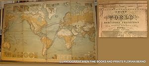
WORLD MAP- 1879 // Chart of the world on Mercators projection : containing the lines of oceanic mail steam communication and overland routes, the international aerial and submarine telegraphs, and the principal tracks of sailing vessels, showing some continental surface characteristics, the oceanic currents and important deep-sea soundings, with 33 additional charts and plans showing the general currents of air, and the lines of equal magnetic variation, the Tehuantepec, Honduras, Nicaragua, Panama, Darien, and Suez routes, several sea ports, the telegraphic and steam lines round the world = Chart of the world zur Übersicht der regelmässigen Dampfschifffahrts-Linien und Überland-Routen, der internationalen Land- und Untersee-Telegraphen, sowie der wichtigeren Segelschiffswege, der Bodenbeschaffenheit, der See-Strömungen und neuerer Tiefsee-Messungen, mit 33 Nebenkarten zur Darstellung der Haupt-Windrichtungen und der Linien gleicher magnetischer Missweisung, der Landengen von Tehuantep
Verlag: Perthes, Gotha, 1879
Anbieter: ANTIQUARIAT.WIEN Fine Books & Prints, Wien, Österreich
Verkäuferbewertung 5 von 5 Sternen

Karte
9th edition, original Lithograph / 9. Auflage original Lithographie zu 8 Segmenten auf Leinen gezogen, Gesamtformat ca. 155 x 97 cm; Zustand: gut Weltkarte von Hermann Beghaus (1828-1890) Neffe und Schüler von Heinrich Berghaus. Nephew and pupil of Heinrich Berghaus; und Friedrich v. Stülpnagel (1786-1865) Tooley I, 125, IV, 231 de 350 Landkarte.
-

Hydrographical Chart Of The World On Wright Or Mercators Projection With Tracks Of The Last Circumnavigators From 'A New General Atlas, consisting of A Series of Geographical Designs, on Various Projections, Exhibiting the Form and Component Parts of the Globe; and A Collection of Maps and Charts, Delineating the Natural and Political Divisions of the Empires, Kingdoms and States of the World'.
Verlag: John Thomson & Company, Edinburgh, UK, 1814
Anbieter: Hornseys, Ripon, Vereinigtes Königreich
Verbandsmitglied: PBFA
Verkäuferbewertung 5 von 5 Sternen
EUR 351,29
EUR 28,90 Versand
Versand von Vereinigtes Königreich nach USAAnzahl: 1 verfügbar
In den WarenkorbNo Binding. Zustand: Very Good. Sheet size: 68cm x 53.8cm. From 'A New General Atlas, consisting of A Series of Geographical Designs, on Various Projections, Exhibiting the Form and Component Parts of the Globe; and A Collection of Maps and Charts, Delineating the Natural and Political Divisions of the Empires, Kingdoms and States of the World'. Date c.1814-1816. Crease to central fold line with a short split to the margin. Blank to the reverse. Age-toning, especially to the margins, minor off-setting and slight foxing as usual. Original hand-colouring nice and bright. In very good, bright, clean condition. This is one of a number of these maps that e are currently posting. Please see our other listings or use the keyword: hornseysthomson.
-

General Chart on Mercators Projection. World. Cook's route.
Sprache: Deutsch
Erscheinungsdatum: 1798
Anbieter: Antiquariat im Schloss, Schwaigern, D, Deutschland
Verkäuferbewertung 5 von 5 Sternen
1 Blatt, 26,5 x 21 cm. Antique copperplate engraved map with original hand colouring. Kupferstichkarte mit originaler Handkolorierung. Ränder mit 2 kleinen Fehlstücken, Karte ohne Bildverlust. Sprache: Deutsch Gewicht in Gramm: 900.
-

A General Chart, on Mercator's Projection, to shew the track of the Lion and Hindostan from England to the Gulph of Pekin in China, and of their return to England .
Erscheinungsdatum: 1796
Anbieter: Maggs Bros. Ltd ABA, ILAB, PBFA, London, Vereinigtes Königreich
Verbandsmitglied: ABA ILAB PBFA
Verkäuferbewertung 5 von 5 Sternen
Kunst / Grafik / Poster
EUR 1.786,23
EUR 31,22 Versand
Versand von Vereinigtes Königreich nach USAAnzahl: 1 verfügbar
In den WarenkorbCopperplate engraving, 590 x 935 mm, evidence of old folds. London, 12th April, Map of Europe, Asia and part of Brazil showing the routes taken on Lord Macartney's voyages to and from China, 1792-94, from a volume of plates to George Staunton, An Authentic Account of an Embassy from the King of Great Britain to the Emperor of China, 1797.
-

A General Chart on Mercator's Projection,
Verlag: London, 1796
Karte
No Binding. Zustand: As New. 60 x 93 cm. Large chart issued in the atlas volume of the official account by George Staunton of George Macartney's travels to China. Macartney was Britain's first envoy to China, tasked with convincing Emperor Qianlong to ease restrictions on trade between Great Britain and China. The map shows the track of two ships, the Lion and Hindostan, on their routes from England to China and back. Each day's progress was recorded along the route along with several notations to the dangers along the way.