
Gesamtpreis (1 Artikel Artikel):
Versandziel:

france von dower (6 Ergebnisse)
Direkt zu den wichtigsten Suchergebnissen
Suchfilter
Produktart
- Alle Product Types
- Bücher (4)
- Magazine & Zeitschriften (Keine weiteren Ergebnisse entsprechen dieser Verfeinerung)
- Comics (Keine weiteren Ergebnisse entsprechen dieser Verfeinerung)
- Noten (Keine weiteren Ergebnisse entsprechen dieser Verfeinerung)
- Kunst, Grafik & Poster (Keine weiteren Ergebnisse entsprechen dieser Verfeinerung)
- Fotografien (Keine weiteren Ergebnisse entsprechen dieser Verfeinerung)
- Karten (1)
- Manuskripte & Papierantiquitäten (1)
Zustand Mehr dazu
- Neu (Keine weiteren Ergebnisse entsprechen dieser Verfeinerung)
- Wie Neu, Sehr Gut oder Gut Bis Sehr Gut (Keine weiteren Ergebnisse entsprechen dieser Verfeinerung)
- Gut oder Befriedigend (3)
- Ausreichend oder Schlecht (Keine weiteren Ergebnisse entsprechen dieser Verfeinerung)
- Wie beschrieben (3)
Einband
- alle Einbände
- Hardcover (Keine weiteren Ergebnisse entsprechen dieser Verfeinerung)
- Softcover (2)
Weitere Eigenschaften
- Erstausgabe (Keine weiteren Ergebnisse entsprechen dieser Verfeinerung)
- Signiert (Keine weiteren Ergebnisse entsprechen dieser Verfeinerung)
- Schutzumschlag (Keine weiteren Ergebnisse entsprechen dieser Verfeinerung)
- Angebotsfoto (6)
Sprache (2)
Gratisversand
- Kostenloser Versand nach USA (Keine weiteren Ergebnisse entsprechen dieser Verfeinerung)
Land des Verkäufers
Verkäuferbewertung
-

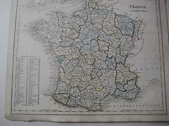
Map of France, 1850 Antique Engraving
Verlag: Orr, UK, 1850
Anbieter: Maynard & Bradley, Leicester, Vereinigtes Königreich
Verkäuferbewertung 5 von 5 Sternen

EUR 15,43
EUR 25,39 Versand
Versand von Vereinigtes Königreich nach USAAnzahl: 1 verfügbar
In den WarenkorbSoftcover. Zustand: Good. 1850. A fairly well-presented map, lightly browned and worn around the outer edges but the majority of the image remaining clear and legible with no major signs of wear. Just a few small nicks reinforced with conservation tape, with no major encroachments onto the print itself, vertical fold line as originally presented. Why on Amazon do most sellers not describe their actual book? Buy with confidence and support a genuine Independent Bricks & Mortar Real Bookshop. We are Maynard & Bradley CAMBO & PBFA(now lapsed) members here in Leicester City Centre. Size: 300 x 240 mm. 1. Item Type: Book. Quantity Available: 1. Shipped Weight: Under 500 grams. Category: Geography & Maps; Britain/UK; 19th century; Inventory No: 47265.
-

FRANCE.
Verlag: Orr & Comp Amen Corner Paternoster Row Ca1870, 1870
Anbieter: PROCTOR / THE ANTIQUE MAP & BOOKSHOP, DORCHESTER, Vereinigtes Königreich
Verbandsmitglied: PBFA
Verkäuferbewertung 5 von 5 Sternen
EUR 15,49
EUR 23,13 Versand
Versand von Vereinigtes Königreich nach USAAnzahl: 1 verfügbar
In den WarenkorbSize of engraved surface: 25cm x 30cm. In very good condition. Red pen markings on map. Uncoloured.
-
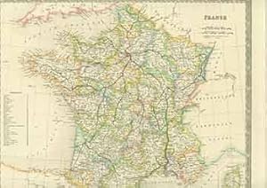
![Bild des Verkäufers für France [Map] zum Verkauf von Renaissance Books, ANZAAB / ILAB](https://pictures.abebooks.com/inventory/md/md30544858382.jpg)
France [Map]
Verlag: Orr & Company [c1849], London, 1849
Anbieter: Renaissance Books, ANZAAB / ILAB, Dunedin, Neuseeland
Verkäuferbewertung 5 von 5 Sternen
Karte
Map. Zustand: Very Good. Zustand des Schutzumschlags: No Dust Jacket. Moderate foxing. 2 folds. ; No date [c1849]. Dimensions: oblong 272 x 220mm. Drawn and engraved by I. Dower. This map is from James Bell, "A System of Geography, Popular and Scientific [. . .] Vol. II" (London: A. Fullarton and Co., 1849).
-
France
Sprache: Deutsch
Erscheinungsdatum: 1850
Anbieter: Alte Bücherwelt, Perg, Österreich
Verkäuferbewertung 4 von 5 Sternen

23 x 23 cm. Original-Landkarte "France" v. J. Dower, hrsg. 1850, Stahlstich koloriert, guer-sehr guter Zustand, kl. Randlässuren, genuine map Sprache: Deutsch Gewicht in Gramm: 450.
-

Orig. Landkarte "France" ca. 1820
Sprache: Deutsch
Verlag: London, Ott & Comp., ca. 1820., 1820
Anbieter: Alte Bücherwelt, Perg, Österreich
Verkäuferbewertung 4 von 5 Sternen
4°, Broschiert. Original Landkarte "France" gest. von J. Dower, hrsg. Ott & Comp., London, ca. 1820, koloriert, Blattgröße ca. 32 x 24 cm.guter-sehr guter Zustand. Sprache: Deutsch Gewicht in Gramm: 850.
-
France. (19th Century Map).
Verlag: London: Henry Teesdale, [1800s]., 1800
Anbieter: Wittenborn Art Books, San Francisco, CA, USA
Verkäuferbewertung 5 von 5 Sternen
Manuskript / Papierantiquität
Zustand: Good. 15 x 19 inches. Very Good. Half in tear at top and bottom edges along fold. 19th Century, folded map, printed in color.