
Gesamtpreis (1 Artikel Artikel):
Versandziel:

environs dublin von s d u k society diffusion useful knowledge (4 Ergebnisse)
Direkt zu den wichtigsten Suchergebnissen
Suchfilter
Produktart
- Alle Product Types
- B³cher (2)
- Magazine & Zeitschriften (Keine weiteren Ergebnisse entsprechen dieser Verfeinerung)
- Comics (Keine weiteren Ergebnisse entsprechen dieser Verfeinerung)
- Noten (Keine weiteren Ergebnisse entsprechen dieser Verfeinerung)
- Kunst, Grafik & Poster (Keine weiteren Ergebnisse entsprechen dieser Verfeinerung)
- Fotografien (Keine weiteren Ergebnisse entsprechen dieser Verfeinerung)
- Karten (2)
- Manuskripte & Papierantiquitõten (Keine weiteren Ergebnisse entsprechen dieser Verfeinerung)
Zustand Mehr dazu
- Neu (Keine weiteren Ergebnisse entsprechen dieser Verfeinerung)
- Wie Neu, Sehr Gut oder Gut Bis Sehr Gut (Keine weiteren Ergebnisse entsprechen dieser Verfeinerung)
- Gut oder Befriedigend (2)
- Ausreichend oder Schlecht (Keine weiteren Ergebnisse entsprechen dieser Verfeinerung)
- Wie beschrieben (2)
Einband
- alle Einbõnde
- Hardcover (Keine weiteren Ergebnisse entsprechen dieser Verfeinerung)
- Softcover (Keine weiteren Ergebnisse entsprechen dieser Verfeinerung)
Weitere Eigenschaften
- Erstausgabe (Keine weiteren Ergebnisse entsprechen dieser Verfeinerung)
- Signiert (Keine weiteren Ergebnisse entsprechen dieser Verfeinerung)
- Schutzumschlag (Keine weiteren Ergebnisse entsprechen dieser Verfeinerung)
- Angebotsfoto (4)
Sprache (1)
Preis
- Beliebiger Preis
- Weniger als EUR 20 (Keine weiteren Ergebnisse entsprechen dieser Verfeinerung)
- EUR 20 bis EUR 45
- Mehr als EUR 45
Gratisversand
- Kostenloser Versand nach USA (Keine weiteren Ergebnisse entsprechen dieser Verfeinerung)
Land des Verkõufers
Verkõuferbewertung
-

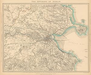
The Environs of Dublin.
Verlag: London, Baldwin & Cradock, 1837. 335 x 400mm (13╝ x 15Š inches)., 1837
Anbieter: Tooley, Adams & Co., Wallingford, OXON, Vereinigtes K÷nigreich
Verkõuferbewertung 5 von 5 Sternen

EUR 33,17
Wõhrung umrechnenEUR 42,73 f³r den Versand von Vereinigtes K÷nigreich nach USAAnzahl: 1 verf³gbar
In den WarenkorbOriginal outline colour; light age-toning to the edges of the margins, light soiling, otherwise a very good example. An early Victorian map of Dublin and the environs, drawn and engraved by B.R.Davies. From the 1844 edition published by Chapman & Hall, for The Society for the Diffusion of Useful Knowledge.
-

The Environs of Dublin.
Verlag: London, Thomas Letts, [1877]. 335 x 400mm (13╝ x 15Š inches)., 1877
Anbieter: Tooley, Adams & Co., Wallingford, OXON, Vereinigtes K÷nigreich
Verkõuferbewertung 5 von 5 Sternen
EUR 42,65
Wõhrung umrechnenEUR 42,73 f³r den Versand von Vereinigtes K÷nigreich nach USAAnzahl: 1 verf³gbar
In den WarenkorbOriginal outline colour; very light age-toning to the edges of the margins, otherwise a fine example. A Victorian map of Dublin and the environs, drawn and engraved by B.R.Davies. From the 1877 edition published by Thomas Letts for The Society for the Diffusion of Useful Knowledge.
-

THE ENVIRONS OF DUBLIN
Erscheinungsdatum: 1847
Anbieter: Antiqua Print Gallery, London, Vereinigtes K÷nigreich
Verkõuferbewertung 3 von 5 Sternen

Karte
EUR 308,03
Wõhrung umrechnenEUR 11,50 f³r den Versand von Vereinigtes K÷nigreich nach USAAnzahl: 1 verf³gbar
In den WarenkorbZustand: Good. IRELAND. The environs of Dublin. Original hand colour. SDUK 1847 old map. Antique steel engraved map with original outline hand colouring; Engraved by BR Davies (1847). 34.0 x 41.0cm, 13.25 x 16 inches. Condition: Good. The image shown may have been taken from a different example of this map than that which is offered for sale. The map you will receive is in good condition but there may be minor variations in the condition from that shown in the image which may include some light spotting. This map was coloured by hand at the time of publication, thus the colouration may vary slightly between different examples of the map; the colouring applied to the map you receive may differ slightly from that shown in the image. There is nothing printed on the reverse side, which is plain.
-
THE ENVIRONS OF DUBLIN
Erscheinungsdatum: 1844
Anbieter: Antiqua Print Gallery, London, Vereinigtes K÷nigreich
Verkõuferbewertung 3 von 5 Sternen
Karte
EUR 308,03
Wõhrung umrechnenEUR 11,50 f³r den Versand von Vereinigtes K÷nigreich nach USAAnzahl: 1 verf³gbar
In den WarenkorbZustand: Good. IRELAND. The environs of Dublin. SDUK 1844 old antique vintage map plan chart. Antique steel engraved map with original hand colouring (color); Engraved by BR Davies (This map was originally published by Baldwin & Cradock in 1837; this date is printed on the map. This edition of the map was printed and published by Chapman & Hall in 1844.). 33.5 x 40.5cm, 13 x 16 inches. Condition: Good. The image shown may have been taken from a different example of this map than that which is offered for sale. The map you will receive is in good condition but there may be minor variations in the condition from that shown in the image. This map was coloured by hand at the time of publication, thus the colouration may vary slightly between different examples of the map; the colouring applied to the map you receive may differ slightly from that shown in the image. There is nothing printed on the reverse side, which is plain.