
Gesamtpreis (1 Artikel Artikel):
Versandziel:

dresden von society diffusion useful knowledge (5 Ergebnisse)
Direkt zu den wichtigsten Suchergebnissen
Suchfilter
Produktart
- Alle Product Types
- Bücher (4)
- Magazine & Zeitschriften (Keine weiteren Ergebnisse entsprechen dieser Verfeinerung)
- Comics (Keine weiteren Ergebnisse entsprechen dieser Verfeinerung)
- Noten (Keine weiteren Ergebnisse entsprechen dieser Verfeinerung)
- Kunst, Grafik & Poster (Keine weiteren Ergebnisse entsprechen dieser Verfeinerung)
- Fotografien (Keine weiteren Ergebnisse entsprechen dieser Verfeinerung)
- Karten (1)
- Manuskripte & Papierantiquitäten (Keine weiteren Ergebnisse entsprechen dieser Verfeinerung)
Zustand Mehr dazu
- Neu (Keine weiteren Ergebnisse entsprechen dieser Verfeinerung)
- Wie Neu, Sehr Gut oder Gut Bis Sehr Gut (Keine weiteren Ergebnisse entsprechen dieser Verfeinerung)
- Gut oder Befriedigend (Keine weiteren Ergebnisse entsprechen dieser Verfeinerung)
- Ausreichend oder Schlecht (Keine weiteren Ergebnisse entsprechen dieser Verfeinerung)
- Wie beschrieben (5)
Einband
- alle Einbände
- Hardcover (Keine weiteren Ergebnisse entsprechen dieser Verfeinerung)
- Softcover (Keine weiteren Ergebnisse entsprechen dieser Verfeinerung)
Weitere Eigenschaften
- Erstausgabe (Keine weiteren Ergebnisse entsprechen dieser Verfeinerung)
- Signiert (Keine weiteren Ergebnisse entsprechen dieser Verfeinerung)
- Schutzumschlag (Keine weiteren Ergebnisse entsprechen dieser Verfeinerung)
- Angebotsfoto (5)
Sprache (1)
Preis
- Beliebiger Preis
- Weniger als EUR 20 (Keine weiteren Ergebnisse entsprechen dieser Verfeinerung)
- EUR 20 bis EUR 45
- Mehr als EUR 45
Gratisversand
- Kostenloser Versand nach USA (Keine weiteren Ergebnisse entsprechen dieser Verfeinerung)
Land des Verkäufers
Verkäuferbewertung
-

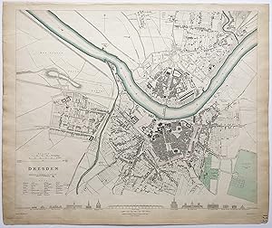
Dresden.
Verlag: London, Baldwin & Cradock, 1833. 320 x 380mm (12˝ x 15 inches)., 1844
Anbieter: Tooley, Adams & Co., Wallingford, OXON, Vereinigtes Königreich
Verkäuferbewertung 3 von 5 Sternen

EUR 28,63
EUR 43,03 Versand
Versand von Vereinigtes Königreich nach USAAnzahl: 1 verfügbar
In den WarenkorbOriginal outline colour; light age-toning to the edges of the margins, minor soilng, otherwise a very good example. An early Victorian detailed plan of the city, drawn by W.B.Clarke and engraved W.Henshall, with the important buildings in profile along the bottom. From the 1844 edition published by Chapman & Hall, for The Society for the Diffusion of Useful Knowledge.
-

Dresden.
Verlag: London, Thomas Letts, [1877]. 320 x 380mm (12˝ x 15 inches)., 1877
Anbieter: Tooley, Adams & Co., Wallingford, OXON, Vereinigtes Königreich
Verkäuferbewertung 3 von 5 Sternen
EUR 38,18
EUR 43,03 Versand
Versand von Vereinigtes Königreich nach USAAnzahl: 1 verfügbar
In den WarenkorbOriginal outline colour; a fine example. A Victorian detailed plan of the city, drawn by W.B.Clarke and engraved by W.Henshall, with the important buildings in profile along the bottom. From the 1877 edition published by Thomas Letts for The Society for the Diffusion of Useful Knowledge.
-
Dresden.
Erscheinungsdatum: 1833
Anbieter: Altea Antique Maps, London, Vereinigtes Königreich
Verbandsmitglied: ABA ILAB PBFA
Verkäuferbewertung 5 von 5 Sternen

Karte
EUR 35,79
EUR 40,54 Versand
Versand von Vereinigtes Königreich nach USAAnzahl: 1 verfügbar
In den WarenkorbLondon, Baldwin & Cradock, 1833. Original outline colour. Steel-engraving, 330 x 390mm. Detailed town plan, with elevations of the most important buildings under the map.
-

Dresden.
Verlag: London. 1833, 1833
Anbieter: Peter Harrington. ABA/ ILAB., London, Vereinigtes Königreich
Verbandsmitglied: ABA ILAB PBFA
Verkäuferbewertung 5 von 5 Sternen
EUR 131,24
EUR 25,48 Versand
Versand von Vereinigtes Königreich nach USAAnzahl: 1 verfügbar
In den WarenkorbA detailed map of Dresden showing the river dividing the city. It has a note in bottom left corner translating relevant German words into English and an attractive row of vignettes of major structures of the city along the bottom margin. Published by Baldwin & Craddock. Size: 345 x 410 mm. Steel engraving. Good condition. Small tear to lower central fold. Toned.
-

Dresden.
Verlag: London. 1847, 1847
Anbieter: Peter Harrington. ABA/ ILAB., London, Vereinigtes Königreich
Verbandsmitglied: ABA ILAB PBFA
Verkäuferbewertung 5 von 5 Sternen
EUR 143,17
EUR 25,48 Versand
Versand von Vereinigtes Königreich nach USAAnzahl: 1 verfügbar
In den WarenkorbA wonderful plan of Dresden. The detailed plan clearly shows the cities expansion on either side of the river Elbe. Below the plan are illusterations showing elevations of the cities major public buildings. Published by Charles Knight for the SDUK. Size: 335 x 430 mm. Steel engraving with original outline colour. Fair condition. Some staining and creasing to the plan.