Denmark von thomson john (9 Ergebnisse)

Sprache: Deutsch
Verlag: Edinburgh 1817
- Karte
Anbieter: Antiquariat Steffen Völkel GmbH, Seubersdorf, DeutschlandAntiquariat Steffen Völkel GmbH
Verkäufer/-in kontaktierenVerkäufer/-in mit 5 SternenZustand: Gebraucht
EUR 29,99
EUR 30,00 VersandVersand von Deutschland nach USAAnzahl: 1 verfügbar
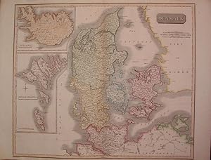
original altkolorierte Kupferstich-Karte aus: "Thomson: New General Atlas" | original old colored copper engraved map out of "Thomson: New General Atlas" | Blatt-Format: ca. 72 x 53 cm - etwas gebräunt und fleckig, sonst gut erhalten. | size of sheet: circa 28.3 x 20.8 inches - some browning and staining, otherwise in good condi…tion. // Wir, das Antiquariat Steffen Völkel, kaufen und verkaufen alte Bücher, Handschriften, Zeichnungen, Autographen, Grafiken und Fotografien. Wir sind stets am Ankauf von kompletten Bibliotheken, Sammlungen und Nachlässen interessiert. Sprache: Deutsch Gewicht in Gramm: 1500.

Verlag: John Thomson & Company, Edinburgh, UK 1814
Anbieter: Hornseys, Ripon, , Vereinigtes KönigreichHornseys
Verkäufer/-in kontaktierenVerkäufer/-in mit 5 SternenZustand: Gebraucht - Gut
EUR 113,40
EUR 28,97 VersandVersand von Vereinigtes Königreich nach USAAnzahl: 1 verfügbar
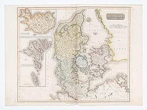
No Binding. Zustand: Very Good. Sheet size: 68cm x 53.8cm. From 'A New General Atlas, consisting of A Series of Geographical Designs, on Various Projections, Exhibiting the Form and Component Parts of the Globe; and A Collection of Maps and Charts, Delineating the Natural and Political Divisions of the Empires, Kingdoms and Stat…es of the World'. Date c.1814-1816. Crease to central fold line. Blank to the reverse. Age-toning, minor off-setting and slight foxing as usual. Original hand-colouring nice and bright. In very good, bright, clean condition. This is one of a number of these maps that e are currently posting. Please see our other listings or use the keyword: hornseysthomson.

Verlag: John Thomson & Company, Edinburgh, UK 1814
Anbieter: Hornseys, Ripon, , Vereinigtes KönigreichHornseys
Verkäufer/-in kontaktierenVerkäufer/-in mit 5 SternenZustand: Gebraucht - Gut
EUR 161,14
EUR 28,97 VersandVersand von Vereinigtes Königreich nach USAAnzahl: 1 verfügbar
No Binding. Zustand: Very Good. Sheet size: 68cm x 53.8cm. From 'A New General Atlas, consisting of A Series of Geographical Designs, on Various Projections, Exhibiting the Form and Component Parts of the Globe; and A Collection of Maps and Charts, Delineating the Natural and Political Divisions of the Empires, Kingdoms and Stat…es of the World'. Date c.1814-1816. Crease to central fold line. Blank to the reverse. Age-toning, minor off-setting and slight foxing as usual. Original hand-colouring nice and bright. In very good, bright, clean condition. This is one of a number of these maps that we are currently posting. Please see our other listings or use the keyword: hornseysthomson.
Verlag: John Thomson, Edinburgh 1814
Anbieter: Argosy Book Store, ABAA, ILAB, New York, NY, USAArgosy Book Store, ABAA, ILAB
Verkäufer/-in kontaktierenVerkäufer/-in mit 5 SternenZustand: Gebraucht - Gut
EUR 200,21
EUR 5,18 VersandVersand innerhalb von USAAnzahl: 1 verfügbar
unbound. Zustand: very good. Map. Engraving with beautiful original hand outline. Image measures 20" x 23.25". Includes insets of Iceland and the Faroe Islands. Schleswig is shown as part of Denmark, whereas today is in part of German. Minor discoloration along centerfold and some wear to upper left corner. From Thomson's "New G…eneral Atlas". John Thomson (1777 - 1837) was a Scottish bookseller and publisher active in the early 19th century, who was one of the leaders in Europe who favored detailed and accurate mapping over the decorative and elaborate cartouches that appeared in earlier maps. His most important work was "Thomson's New General Atlas" and his "Atlas of Scotland". Although he went into bankruptcy twice during his career, his maps are today highly desirable for their scale and detail. This is beautiful example of his work.

Verlag: A New General Atlas. Edinburgh: Printed by Ben Stark for John Thomson. 1827 1827
Anbieter: Peter Harrington. ABA/ ILAB., London, Vereinigtes KönigreichPeter Harrington. ABA/ ILAB.
Verkäufer/-in kontaktierenVerkäufer/-in mit 5 SternenZustand: Gebraucht
EUR 238,73
EUR 25,50 VersandVersand von Vereinigtes Königreich nach USAAnzahl: 1 verfügbar
Attractive map of Denmark with two insets to the left. Title at top right with threescales underneath The New General Atlas was one of the most accurate and best produced atlases of the day. John Thomson's 'County Atlas of Scotland' is generally considered the finest of its kind. Copper engraving. Fine condition. Original outlin…e colour. Size: 59 x 50 cm. (23 x 19½ inches).

Verlag: A New General Atlas. Edinburgh: Printed by Ben Stark for John Thomson. 1827 1827
Anbieter: Peter Harrington. ABA/ ILAB., London, Vereinigtes KönigreichPeter Harrington. ABA/ ILAB.
Verkäufer/-in kontaktierenVerkäufer/-in mit 5 SternenZustand: Gebraucht
EUR 316,32
EUR 25,50 VersandVersand von Vereinigtes Königreich nach USAAnzahl: 1 verfügbar
Beautiful map of Scandinavia. The New General Atlas was one of the most accurate and best produced atlases of the day. John Thomson's 'County Atlas of Scotland' is generally considered the finest of its kind. Copper engraving. Closed tear on left centrefold, margin only. Fine condition. Original colour. Size: 47 x 55 cm. (18½ x…21½ inches).
Verlag: EdinburghJohn Thomson. 1828
- Karte
Anbieter: Robert Frew Ltd. ABA ILAB, London, , Vereinigtes KönigreichRobert Frew Ltd. ABA ILAB
Verkäufer/-in kontaktierenVerkäufer/-in mit 5 SternenZustand: Gebraucht
EUR 358,10
EUR 11,59 VersandVersand von Vereinigtes Königreich nach USAAnzahl: 1 verfügbar
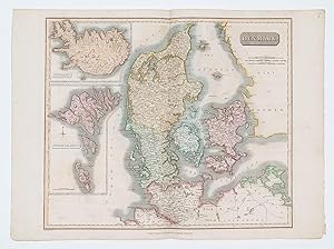
59 x 49 cm. (Sheet 73 x 53 cm.) Original full hand-colour. Double page map of Denmark with insets of Iceland and the Feroe Islands. Very good. Issued in the 1828 edition of Thomson's "New General Atlas.with the new discoveries to the date of publication".

Verlag: EdinburghJohn Thomson. 1828
- Karte
Anbieter: Robert Frew Ltd. ABA ILAB, London, , Vereinigtes KönigreichRobert Frew Ltd. ABA ILAB
Verkäufer/-in kontaktierenVerkäufer/-in mit 5 SternenZustand: Gebraucht
EUR 358,10
EUR 11,59 VersandVersand von Vereinigtes Königreich nach USAAnzahl: 1 verfügbar
55 x 47 cm. (Sheet 73 x 53 cm.) Original full hand-coloured double page map. Very good. Issued in the 1828 edition of Thomson's "New General Atlas.with the new discoveries to the date of publication".
Verlag: EdinburghJohn Thomson. 1817 1814
- Karte
Anbieter: Robert Frew Ltd. ABA ILAB, London, , Vereinigtes KönigreichRobert Frew Ltd. ABA ILAB
Verkäufer/-in kontaktierenVerkäufer/-in mit 5 SternenZustand: Gebraucht
EUR 358,10
EUR 11,59 VersandVersand von Vereinigtes Königreich nach USAAnzahl: 1 verfügbar
55 x 47 cm. (Sheet 70 x 55 cm.) Original full hand-colour. Double page map of Denmark with insets of Iceland and the Feroe Islands engraved by Dassauville. Very good. Issued in the 1817 edition of Thomson's 'New General Atlas'.


