Gesamtpreis (1 Artikel Artikel):
Versandziel:

danckerts justus (20 Ergebnisse)
Direkt zu den wichtigsten Suchergebnissen
Suchfilter
Produktart
- Alle Product Types
- Bücher (5)
- Magazine & Zeitschriften (Keine weiteren Ergebnisse entsprechen dieser Verfeinerung)
- Comics (Keine weiteren Ergebnisse entsprechen dieser Verfeinerung)
- Noten (Keine weiteren Ergebnisse entsprechen dieser Verfeinerung)
- Kunst, Grafik & Poster (2)
- Fotografien (Keine weiteren Ergebnisse entsprechen dieser Verfeinerung)
- Karten (13)
- Manuskripte & Papierantiquitäten (Keine weiteren Ergebnisse entsprechen dieser Verfeinerung)
Zustand Mehr dazu
- Neu (Keine weiteren Ergebnisse entsprechen dieser Verfeinerung)
- Wie Neu, Sehr Gut oder Gut Bis Sehr Gut (2)
- Gut oder Befriedigend (7)
- Ausreichend oder Schlecht (Keine weiteren Ergebnisse entsprechen dieser Verfeinerung)
- Wie beschrieben (11)
Einband
- alle Einbände
- Hardcover (3)
- Softcover (Keine weiteren Ergebnisse entsprechen dieser Verfeinerung)
Weitere Eigenschaften
- Erstausgabe (Keine weiteren Ergebnisse entsprechen dieser Verfeinerung)
- Signiert (Keine weiteren Ergebnisse entsprechen dieser Verfeinerung)
- Schutzumschlag (Keine weiteren Ergebnisse entsprechen dieser Verfeinerung)
- Angebotsfoto (20)
Sprache (2)
Preis
- Beliebiger Preis
- Weniger als EUR 20 (Keine weiteren Ergebnisse entsprechen dieser Verfeinerung)
- EUR 20 bis EUR 40 (Keine weiteren Ergebnisse entsprechen dieser Verfeinerung)
- Mehr als EUR 40
Gratisversand
- Kostenloser Versand nach USA (Keine weiteren Ergebnisse entsprechen dieser Verfeinerung)
Land des Verkäufers
Verkäuferbewertung
-
Artesia-Novissima, anno 1690, Danckerts Justus, map
Verlag: Danckerts Cornelis + Justus
Anbieter: Hammelburger Antiquariat, Hammelburg, Deutschland
Verkäuferbewertung 5 von 5 Sternen

Hardcover. Zustand: very good. Artesia-Novissima, anno 1690, Danckerts Justus, map. Size of the leaf: 52x60 cm., small tears on margins, little brownish, small restoration on below centerfold (20 cm.).
-
Geldria/Zutphania map, anno 1680, Danckerts Justus, scarce map
Verlag: Danckerts Cornelis + Justus
Anbieter: Hammelburger Antiquariat, Hammelburg, Deutschland
Verkäuferbewertung 4 von 5 Sternen

Hardcover. Zustand: very good. Coppermap, edited by Justus Danckerts, anno 1680, size of the leaf: 53x64 cm., below centerfold restored for 15 cm.
-

Italiae,Generalmap,anno 1690, Danckerts Justus, nice colours
Verlag: Danckerts Cornelis + Justus
Anbieter: Hammelburger Antiquariat, Hammelburg, Deutschland
Verkäuferbewertung 4 von 5 Sternen
Hardcover. Zustand: very good. Italiae,Generalmap,anno 1690, Danckerts Justus, nice colours Coppermap, edited by Justus Danckerts, anno 1690, some small folds in the centerfold, size of the leaf: 52 x 62 cm. Contemporary coloured in outline, the cartouche full old coloured.
-
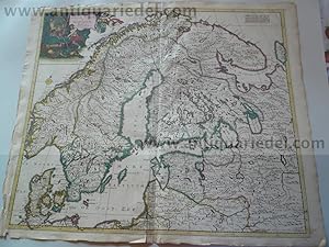
Northern Europe, Russia, Baltic Sea, anno 1680, Danckerts Justus
Verlag: Danckerts Cornelis + Justus, 1680
Anbieter: Hammelburger Antiquariat, Hammelburg, Deutschland
Verkäuferbewertung 4 von 5 Sternen
Karte
Kein Einband. Zustand: Befriedigend. "Accuratissima Regnorum Sueciae, Daniae, et Norvegiae, Tabula. Per Iustinum Danckerts, cum privilegio". Coppermap, edited by Danckerts, size of the leaf: 54x64 cm., some restored cracs on margins, browned on margins, restored centerfold. For more infos please click below button.
-
Novissima et accuratissima canalis inter Angliae., anno 1690, scarce map by Danckerts Justus, old colours--VERY SCARCE MAP---- Channel,map, anno 1690, Danckerts J. Coppermap, edited by Justus Danckerts, size of the leaf: 53 x 64 cm., contemporary coloured in outline, little cracs on margins, the surface of the map is ok.
Verlag: Danckerts Cornelis + Justus, 1690
Anbieter: Hammelburger Antiquariat, Hammelburg, Deutschland
Verkäuferbewertung 5 von 5 Sternen
Karte
Kein Einband. Zustand: Gut. Novissima et accuratissima canalis inter Angliae., anno 1690, scarce map by Danckerts Justus, old colours--VERY SCARCE MAP---- Channel,map, anno 1690, Danckerts J. Coppermap, edited by Justus Danckerts, size of the leaf: 53 x 64 cm., contemporary coloured in outline, little cracs on margins, the surface of the map is ok.
-
Rheinlauf, anno 1690, Danckerts Justus, altkoloriert
Verlag: Danckerts Cornelis + Justus
Anbieter: Hammelburger Antiquariat, Hammelburg, Deutschland
Verkäuferbewertung 5 von 5 Sternen
Karte
Kein Einband. Zustand: Gut. "Totius Fluminis Rheni Novissima Descriptio ex Officina I. Danckerts". Kupferstich-Karte von I.Danckerts, ca. 1690, altkoloriert. 45,5 x 52 cm. Zeigt in zwei übereinanderliegenden Teilen den Rhein von den Quellen bis zur Mündung. Links dekorative kolorierte Titelkartusche mit Mars, Fama, Bacchus und Putto mit Füllhorn. Rechts unten Meilenzeiger mit Meerwesen und maritime Staffage. Kartenteile können zusammengesetzt werden. Gering gebräunt, etwas fingerfleckig, ansonsten gut.
-
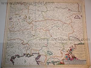
Austria/Northern Italy, anno 1690, Danckerts Justus
Verlag: Danckerts Cornelis + Justus, 1690
Anbieter: Hammelburger Antiquariat, Hammelburg, Deutschland
Verkäuferbewertung 5 von 5 Sternen
Karte
Kein Einband. Zustand: Befriedigend. Austria/Northern Italy, anno 1690, Danckerts Justus Please read german textKupferkarte, verlegt durch Justus Danckerts, ca anno 1690: "CIRCULI AUSTRIACI in quo sunt ARCHIDUCATUS AUSTRIAE DUCATUS STIRIAE CARINTIAE CARNIOLAE COMITATUS TIROLIS et EPISCOPATUS TRIDENTINI Novissima Desdriptio AMSTELODAMI per IUSTINUM DANCKERTS cum Privilegio." Zeitgenössisches Grenzkolorit, an den Rändern etwas stockfleckig. Blattmaß: 52 x 62 cm.
-

Utrecht/Het Gooi - Justus Danckerts, 1700
Anbieter: Inter-Antiquariaat Mefferdt & De Jonge, Amsterdam, Niederlande
Verkäuferbewertung 4 von 5 Sternen
Karte
"Dominii Ultraiectini Tabula". Copper engraving published in 1700 by Justus Danckerts in Amsterdam. With original hand colouring. Size approx. 46 × 54.5 cm. This map centers on the city of Utrecht and depicts the area between Amsterdam, Amersfoort, and Schoonhoven, showing the region's vast system of canals and polders. The piece is richly decorated with a figurative cartouche featuring the coat of arms of Utrecht, the archbishop, and cherubs carrying the land's produce. A small compass rose in the lower right corner indicates that north is positioned at the lower right. The scale bars, placed in another cartouche at the lower right, show distances measured in "hours' walking" (uren gaans) and German miles. The Danckerts family was a renowned publisher of maps, prints, and books in 17th-century Amsterdam. The publishing house had a long history, founded around 1633 when Cornelis Danckerts I (the elder) began as a dealer in papiere const (paper art) and maps. The Danckerts publishing firm reached its greatest fame when Justus Danckerts I (16351701) and his two sons Theodorus I (16631727) and Cornelis II (16641717) were active. From 1669 to 1701, Justus I and his sons operated a shop in the building In de Danckbaerheyt on Kalverstraat. Price: Euro 425,-.
-

Carnation, tulip and lily - Justus Danckerts, c
Anbieter: Inter-Antiquariaat Mefferdt & De Jonge, Amsterdam, Niederlande
Verkäuferbewertung 4 von 5 Sternen
Kunst / Grafik / Poster
Carnation, tulip, and lily, etching published by Justus Danckerts around 1680 as part of a series of 12 individual prints of flowers. Coloured by a later hand. Size (plate mark): 18.6 x 13.5 cm. The Danckerts family was a well-known publisher of maps, prints, and books in 17th-century Amsterdam. The publishing house was active for a long time, having been founded around 1633 when Cornelis Danckerts I (the elder) started as a seller of "Papiere const en Caerten" (paper art and maps). The Danckerts publishing house gained its greatest fame when Justus Danckerts (16351701) and his two sons, Theodorus I (16631727) and Cornelis II (16641717), were active. From 1669 to 1701, Justus and his sons operated a shop in a building on Kalverstraat with the name "In de Danckbaerheyt" [litterally: "In Gratitude", or The House of Thankerts]. Price: Euro 450,-.
-

Lily, iris and tulip - Justus Danckerts, c
Anbieter: Inter-Antiquariaat Mefferdt & De Jonge, Amsterdam, Niederlande
Verkäuferbewertung 4 von 5 Sternen
Kunst / Grafik / Poster
Lily, iris and tulip, etching published by Justus Danckerts around 1680 as part of a series of 12 individual prints of flowers. Coloured by a later hand. Size (plate mark): 18.6 x 13.5 cm. The Danckerts family was a well-known publisher of maps, prints, and books in 17th-century Amsterdam. The publishing house was active for a long time, having been founded around 1633 when Cornelis Danckerts I (the elder) started as a seller of "Papiere const en Caerten" (paper art and maps). The Danckerts publishing house gained its greatest fame when Justus Danckerts (16351701) and his two sons, Theodorus I (16631727) and Cornelis II (16641717), were active. From 1669 to 1701, Justus and his sons operated a shop in a building on Kalverstraat with the name "In de Danckbaerheyt" [litterally: "In Gratitude", or The House of Thankerts]. Price: Euro 450,-.
-

Greece, Balkans - Justus Danckerts, 1684
Anbieter: Inter-Antiquariaat Mefferdt & De Jonge, Amsterdam, Niederlande
Verkäuferbewertung 4 von 5 Sternen
Karte
Regni Hungariae, Graeciae et Moreae ac Regionum, quae ei quondam fuere Christiani ut Transilvaniae, Valachiae, Moldaviae, Bessarabiae, Croatiae, Romaniae, Dalmatiae, Morlachiae, Ragusanae Republicae, Maximaeq Partis Danubii Fluminis [The Kingdoms of Hungary, Greece, and Morea and regions which formerly belonged to Christians such as Transilvania, Wallachia, Moldavia, Bessarabia, Croatia, Romania, Dalmatia, Morlachia, Republic of Ragusa, and the greatest part of the Danube River], copper engraving published in Amsterdam by Justus Danckerts in 1684. With original hand colouring and heightened with gold. Size: 51,2 x 59,9 cm. This nice map of the greater Balkan region, follows the course of the Danube from Passau to the Black Sea. The map was engraved during the Great Turkish War between the Ottoman Empire and the Holy League consisting of the Holy Roman Empire, Poland-Lithuania, Venice, Russia, and Habsburg Hungary. Intensive fighting began in 1683 and ended with the signing of the Treaty of Karlowitz in 1699. The war was a defeat for the Ottoman Empire, which for the first time lost large amounts of territory, in Hungary and the PolishLithuanian Commonwealth, as well as part of the western Balkans. The war is illustrated by a scene of fighting soldiers left of the title cartouche. Price: Euro 575,-.
-

Seventeen Provinces - Justus Danckerts, c
Anbieter: Inter-Antiquariaat Mefferdt & De Jonge, Amsterdam, Niederlande
Verkäuferbewertung 4 von 5 Sternen
Karte
"Novissima et accuratissima XVII Provinciarum Germaniae Inferioris Delineatio" [Newest and most accurate depiction of the XVII Provinces of the Netherlands]. Copper engraving made by Abraham Deur (active 16661714), published by Justus Danckerts around 1680. With beautiful original hand colouring. Size approx. 47.5 x 56 cm. At the top of the title cartouche stand Athena, the goddess of wisdom, accompanied by her owl, and Fama, the goddess of eternal fame, with her trumpets. Also adorning the title is Hercules, with his club and the lion's skin cape from the beast he conquered. Watching over the Netherlands are Fortuna, the goddess of prosperity, holding the Horn of Plenty, and Ceres, goddess of the grain harvest. On the legend to the left is the ascending Dutch Lion, beneath which hangs the family coat of arms of Johan Munter. Munter was a wealthy Amsterdam merchant who held the office of mayor of Amsterdam between 1670 and 1683. The map is dedicated to him. With the Fall of Antwerp in 1585, a de facto separation occurred between the Northern and Southern Netherlands, causing the seventeen provinces to split into two parts. A border was created, dividing the Seventeen Provinces into the Dutch Republic and the Southern Netherlands. Due to emigration and the political situation, the economic center of gravity shifted to the north. The revolt against the Spanish continued, and at the same time, religion was dividing the entire continent in two. All of Europe became a major theater of war, and the conflicts were not resolved until 1648 with the Peace of Münster. In this treaty, among other things, Spain officially recognized the Dutch Republic as a sovereign state. The separation of the northern and southern Netherlands became final at that point. Nonetheless, maps of the Seventeen Provinces continued to appear regularly until about 1800. This was partly due to the enormous cost of fieldwork and engraving required to produce new maps, but also because of the unclear borders in the eastern and southern parts of the Seven Provinces. Literature: Hans Spikmans "Germania Inferior, cartobibliografie van de Zeventien Provinciën der Nederlanden 1548-1831", map 156-1 Price: Euro 850,-.
-

New Netherland, New Amsterdam (New York) - Justus Danckerts, 1690
Anbieter: Inter-Antiquariaat Mefferdt & De Jonge, Amsterdam, Niederlande
Verkäuferbewertung 4 von 5 Sternen
Karte
EUR 6.500,00
EUR 42,00 Versand
Versand von Niederlande nach USAAnzahl: 1 verfügbar
In den WarenkorbNovi Belgii Novaeque Angliae Nec Non Pennsylvaniae et Partis Virginiae Tabula (Map of New Netherland, New England, as well as Pennsylvania and a part of Virginia.) Copper engraving published by Justus Danckerts in Amsterdam in 1690. With original hand colouring. Size: 46.5 x 54.4 cm. At the end of the 16th century, knowledge of the North American coast was still very incomplete in Europe and in The Netherlands. There was an idea that the Pacific and Atlantic oceans were connected by a river that ran through the American continent. The reason for the first Dutch trading voyages to the land that would later be called 'New Netherland' were the discoveries made by Henry Hudson in 1609. In that year, the famous English explorer sailed to the Arctic Ocean. He had been commissioned by the Dutch East India Company (VOC) to attempt finding a shorter route to Asia. However, Hudson interrupted his efforts and set course for North America, where he discovered a large river, which still bears his name. Interest in this area was sparked in the Netherlands, and lucrative prospects for the fur trade (including beaver hides) ignited the entrepreneurial spirit of the Dutch. Different groups of merchants tried to outdo each other. From 1611 to 1614, they each organized their own expeditions to explore this unknown territory. One such figure was Captain Adriaen Block. On behalf of thirteen merchants, he sailed in 1613 to the 'Great River' (today's Hudson River) with the intention of further exploring the trade possibilities of the area. Block returned to the Netherlands with positive stories about the economic potential of this territory. The States-General were also impressed. On October 11, 1614, they granted the "Nieuw-Nederland Compagnie" a trade charter. The united merchants were authorized by the States-General to make four trading voyages to New Netherland. There was no extension of this trade monopoly. The economic interests of this part of the world had become so significant for the Netherlands that in 1621, the States-General established the Dutch West India Company (WIC). Nicolaes Visscher created a map in 1651 based on the manuscript map made by Adriaen Block during his exploratory journey, which he included in his atlases. The copper plate was reused in 1655 by Jan Jansson and once again brought to market "multis in locis emendata" (corrected in many places) in 1690 by Justus Danckerts. In Danckerts' particular copy, the course of the Delaware River has been completely revised, and Pennsylvania is now correctly named. Compared to Visscher's map, Danckerts adorned his map with more wild and farm animals, hence the map is often referred to as the "Farm Animal Map". The land was meant to look more appealing to settlers. The famous view at the bottom right of the map of "Nieuw Yorck eertyds genaemt Nieuw Amsterdam op 't Eyland Manhattans" (New York formerly called New Amsterdam on the Island of Manhattan) was first published around 1650 by Joan Blaeu. The Dutch flag fluttering ("this flag is raised when ships come into the harbor") appears to be directed to the States-General to urge the Dutch West India Company for additional support for the colony in New Amsterdam. However, by the time Danckerts published the map in 1690, it was already too late. From 1664, the settlement was in English hands. Price: Euro 6.500,- (incl. frame).
-

Peloponnese - Justus Danckerts, 1684
Anbieter: Inter-Antiquariaat Mefferdt & De Jonge, Amsterdam, Niederlande
Verkäuferbewertung 4 von 5 Sternen
Karte
BEAUTIFUL MAP OF THE PELOPONNESIAN PENINSULA "Peloponnesus Hodie Moreae Regnum" [Peloponnese known today as Kingdom of Morea], copper engraving published by Justus Danckerts in Amsterdam, 1684. Original hand colouring. Size: 50,9 x 59,5 cm. The map was engraved during the Great Turkish War between the Ottoman Empire and the Holy League consisting of the Holy Roman Empire, Poland-Lithuania, Venice, Russia, and Habsburg Hungary. Intensive fighting began in 1683 and by 1687 the Venetians occupied the entire peninsula, and received recognition by the Ottomans in the Treaty of Karlowitz (1699). The Venetians established their province as the "Kingdom of the Morea". (The Ottomans however, reconquested the peninsula in 1715.) The momentary victory is depicted in the cartouche where a triumphant Venetian lion (winged, with open book and halo around its head) swings its sword whilst captured Ottomans lie at its feet. Price: Euro 950,-.
-

Hungary - Justus Danckerts, 1684
Anbieter: Inter-Antiquariaat Mefferdt & De Jonge, Amsterdam, Niederlande
Verkäuferbewertung 4 von 5 Sternen
Karte
Novissima et accuratissima totius Hungariae tabula [newest and most accurate map of all of Hungary] Nice map of Hungary after the work of Pierre Duval [1618-1683]. Duval was born in Abbeville (France) and moved to Paris along with other Academics and intellectuals at the urging of the French King. Here he eventually became Geographe Ordinaire du Roy. In that position he produced a large number magnificant maps. The map shows Hungary, Transylvania and Slavonia with bordering countries, as well as the course of the Danube between Vienna and 'Bodon'. At the bottom a decorative Cartouche with an Ottoman with drawn sword. (Is he theatening Christian angels') Published by Justus Danckerts 1684. Original hand colouring. Size: 39,6 x 48,2 cm. Price: Euro 625,-.
-
Kupferstich- Karte, b. Justus Danckerts, "Novissima et Accuratissima Helvetiae Rhaetiae, Valesiae et partis Sabaudia".
Sprache: Deutsch
Anbieter: Antiquariat Clemens Paulusch GmbH, Berlin, Deutschland
Verkäuferbewertung 5 von 5 Sternen
Karte
mit altem Grenzkolorit, um 1680, 48,7 x 57 Blumer 124. - Oben links ausgemalte, von Engeln gehaltene, Kartusche. Die Karte zeigt die Schweiz und Savoyen.
-

Brabant - Justus Danckerts - circa 1694
Anbieter: Antiquariaat Dat Narrenschip, Middelburg, Niederlande
Verkäuferbewertung 5 von 5 Sternen
Karte
Zustand: Fine. Ducatus Brabantiae Tabula Continens Sacri Imperii Marchionatum et Dominium Mechliniense de novo accurate emendata Oude, antieke landkaart van het hertogdom Brabant. Fraaie titelcartouche met schaalstokkenrechts onder. Rugzijde blank. Oudtijds gekleurde kopergravure, uitgegeven te Amsterdam door Justus Danckerts omstreeks 1690. Hoogte 57,5 cm; breedte 51 cm.
-

Utrecht - Justus Danckerts - circa 1690
Anbieter: Antiquariaat Dat Narrenschip, Middelburg, Niederlande
Verkäuferbewertung 5 von 5 Sternen
Karte
Zustand: Fine. ULTRAIECTINI DOMINII TABULA Multo aliis auctior et correctior per I. Danckerts.Oude, antieke landkaart van de heerlijkheid (de huidige provincie) Utrecht. Het westen boven. Titel in draperie in cartouche met wapen van Utrecht, bisschop met een miniatuur van de Utrechtse Domkerk in zijn rechterhand en putto links boven. Schaalstokken in cartouche met kwabornamenten rechts onder. Boven deze cartouche een kompasroos en links van deze cartouche het uitgeversimpressum. Rugzijde blank.Oudtijds gekleurde kopergravure, uitgegeven te Amsterdam omstreeks 1690 door Justus Danckerts. Hoogte 45,5 cm; breedte 54 cm.
-
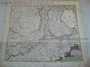
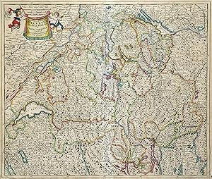
Map of Switzerland by Justus Danckerts, Hand-Colored Engraving ca. 1690
Anbieter: Bartele Gallery - The Netherlands, Langweer, FRL, Niederlande
Verkäuferbewertung 5 von 5 Sternen
Map of Switzerland by Justus Danckerts, Hand-Colored Engraving ca. 1690 This detailed and attractively hand-colored antique map titled *Helvetiae Rhaetiae et Valesiae, nec non partis Sabaudiae Tabula* was engraved and published by Justus Danckerts in Amsterdam around 1690. It depicts the Swiss Confederacy along with neighboring regions, including Rhaetia (modern Graubünden), Valais, and part of Savoy. This is a quintessential example of late 17th-century Dutch cartography?ornate, richly detailed, and both scientifically useful and visually appealing. The map is a masterful representation of the geography of the Swiss Alps and surrounding territories. It features major cities such as Zurich, Bern, Basel, Lucerne, and Geneva (Genčve), along with an exceptional network of rivers, lakes, mountain ranges, and political boundaries. Lake Geneva (Lemanus Lacus) and parts of the Rhône River system are prominently illustrated. The regional borders are highlighted in original hand-color, a practice common in maps from this period to distinguish various cantons and territories. In the upper left, a decorative cartouche with scrollwork, draped fabric, and two allegorical figures presents the title. This style of embellishment, with its bold putti and theatrical flair, is characteristic of the Danckerts workshop and helps distinguish this map from earlier works by Blaeu or Janssonius. Justus Danckerts (1635?1701) came from a renowned family of Dutch mapmakers and publishers. He was part of the third generation of the Danckerts firm and was known for producing high-quality wall maps, atlases, and decorative engravings. His maps were prized for their clarity, vivid hand-coloring, and elegant ornamentation. This map serves as both a collector's piece and a decorative artifact of late Dutch Golden Age cartography. It captures a richly detailed vision of Switzerland at a time when it was forming its independent identity in the heart of Europe. Condition report: Well-preserved, considering age, but with some edge wear, light age toning, but mostly in the borders. The image itself mostly a clean and detailed sharp impression. Tips for Framng: Best framed in dark walnut or gold-leaf wood, with an off-white or pale grey mat to enhance the map's intricate linework and rich period coloring.
-
Antique Map of Piedmont, Savoy and Liguria by Justus Danckerts, Amsterdam c.1690
Anbieter: Bartele Gallery - The Netherlands, Langweer, FRL, Niederlande
Verkäuferbewertung 5 von 5 Sternen
Map of Piedmont, Savoy and Liguria by Justus Danckerts, Amsterdam c.1690 This richly detailed and decorative map, titled *Tabula Generalis Ducatus Sabaudiae Principatus Pedemontii Comitatum Nicaeensis et Ducatus Montisferrati*, was published around 1690 by the Amsterdam cartographer Justus Danckerts (Iustinus Danckerus). He was one of the leading mapmakers in the Netherlands during the late 17th century, part of a family renowned for producing finely engraved and colored maps. The map covers a large swath of Northern Italy and parts of southeastern France, focusing on the Duchy of Savoy, the Principality of Piedmont, the County of Nice, and the Ligurian coast, including Genoa. It reflects the strategic and political importance of these territories, especially during a time of shifting alliances and ongoing wars among European powers. Danckerts's map stands out for its clarity and precision, showing a dense network of cities, rivers, mountain ranges, and territorial boundaries. The Alps are rendered in expressive hachuring, and each region is outlined in hand-applied color. Prominent cities such as Turin, Nice, and Genoa are labeled, as well as key geographic features like Lake Geneva, the Po River, and the Mediterranean coast. A beautifully ornate cartouche at the lower right features allegorical figures, coats of arms, and a dedication, highlighting the grandeur and authority of the map. The artistry and execution are typical of Dutch Golden Age cartography?both practical and decorative. This map would have served as an important reference for military strategists, diplomats, and merchants operating in this politically significant region at the crossroads of France and Italy. Condition summary: Very good condition with original hand-color, central fold as issued, mild age toning. Strong impression but tight margins and some borders reinforced. A fine example of late 17th-century Dutch cartography. Framing tips: Best displayed in a dark wood or gold-leaf frame with a cream or soft beige mat to bring out the color contrast. Use UV-protective glass to preserve the hand-coloring and paper integrity over time.