
Gesamtpreis (1 Artikel Artikel):
Versandziel:

county map minnesota (11 Ergebnisse)
Direkt zu den wichtigsten Suchergebnissen
Suchfilter
Produktart
- Alle Product Types
- Bücher (8)
- Magazine & Zeitschriften (Keine weiteren Ergebnisse entsprechen dieser Verfeinerung)
- Comics (Keine weiteren Ergebnisse entsprechen dieser Verfeinerung)
- Noten (Keine weiteren Ergebnisse entsprechen dieser Verfeinerung)
- Kunst, Grafik & Poster (Keine weiteren Ergebnisse entsprechen dieser Verfeinerung)
- Fotografien (Keine weiteren Ergebnisse entsprechen dieser Verfeinerung)
- Karten (3)
- Manuskripte & Papierantiquitäten (Keine weiteren Ergebnisse entsprechen dieser Verfeinerung)
Zustand Mehr dazu
- Neu (Keine weiteren Ergebnisse entsprechen dieser Verfeinerung)
- Wie Neu, Sehr Gut oder Gut Bis Sehr Gut (Keine weiteren Ergebnisse entsprechen dieser Verfeinerung)
- Gut oder Befriedigend (4)
- Ausreichend oder Schlecht (Keine weiteren Ergebnisse entsprechen dieser Verfeinerung)
- Wie beschrieben (7)
Einband
- alle Einbände
- Hardcover (Keine weiteren Ergebnisse entsprechen dieser Verfeinerung)
- Softcover (Keine weiteren Ergebnisse entsprechen dieser Verfeinerung)
Weitere Eigenschaften
- Erstausgabe (3)
- Signiert (Keine weiteren Ergebnisse entsprechen dieser Verfeinerung)
- Schutzumschlag (Keine weiteren Ergebnisse entsprechen dieser Verfeinerung)
- Angebotsfoto (9)
Sprache (2)
Gratisversand
- Kostenloser Versand nach USA (Keine weiteren Ergebnisse entsprechen dieser Verfeinerung)
Land des Verkäufers
Verkäuferbewertung
-

Aeromagnetic Map of Minnesota. St. Louis County.
Verlag: Minnesota Geological Survey Map A-2, 1983, folded map in envelope., 1983
Anbieter: Eryops Books, Stephenville, TX, USA
Verkäuferbewertung 5 von 5 Sternen

Karte
Folded map in printed envelope; ex-library; light creasing to edges of envelope; o/w very good condition. Map.
-
Reconnaissance Geologic Map of the Northwest Angle, Lake of the Woods County, Minnesota (Minnesota Geological Survey - The University of Minnesota Miscellaneous Map Series, Map M-74).
Verlag: Minnesota Geological Survey., 1991
Anbieter: Eryops Books, Stephenville, TX, USA
Verkäuferbewertung 5 von 5 Sternen
Karte
No Binding. Zustand: Very Good. Large Folded sheet; INCLUDES geologic map, correlation of map units, description of map units, a discussion of geology/economic geology, tables summarizing chemical analysis of rocks and trace elements; and references cited; in very good condition. Map.
-
County Map of Minnesota
Sprache: Englisch
Verlag: [W.M. Bradley & Bro.], [Philadelphia], 1886
Anbieter: Kaaterskill Books, ABAA/ILAB, East Jewett, NY, USA
Verbandsmitglied: ABAA ILAB IOBA
Verkäuferbewertung 5 von 5 Sternen
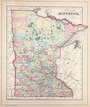
Zustand: Very good, faint toning. Hand colored map. 11.5 x 13.75 inches. Plate 81: County Map of Minnesota. Copyright by S. Augustus Mitchell 1884. From: Mitchell's New General Atlas, Containing Maps Of The Various Countries Of The World, Plans Of Cities, Etc., Embraced In Ninety-Three Quarto Maps, Forming A Series Of One Hundred and Forty-seven Maps and Plans, Together With Valuable Statistical Tables. Also, A List Of Post-Offices Of The United States And Territories, And Also Census Of 1880 For States, Territories And Counties, Also Of Cities Of Over 10,000 Inhabitants. Philadelphia: Published By Wm. M. Bradley & Bro., No. 1026 Arch Street. 1886.
-

New Rail Road and County Map of Minnesota
Sprache: Englisch
Verlag: George F. Cram, [Chicago], 1882
Anbieter: Kaaterskill Books, ABAA/ILAB, East Jewett, NY, USA
Verbandsmitglied: ABAA ILAB IOBA
Verkäuferbewertung 5 von 5 Sternen
One sheet (30 x 35 cm). 28.5 x 21.5 cm. (10 1/4 x 8 1/2 inches). Hand colored. Title inside oval cartouche. Scale 36 miles to 1 inch. Taken from "Cram's Illustrated Family Atlas of the World." There were numerous versions of the New Rail Road and County maps by published by Cram and Henry S. Stebbins, with later versions machine colored due to the expense of hand coloring. Phillips 901. Very good, light marginal browning.
-
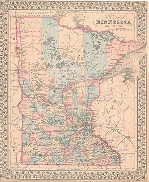
County Map of Minnesota
Verlag: S. Augustus Mitchell, Jr., New York, 1880
Anbieter: Main Street Fine Books & Mss, ABAA, Galena, IL, USA
Verbandsmitglied: ABAA ILAB MWABA
Verkäuferbewertung 5 von 5 Sternen
Karte
Folio (12Ľ" X 15Ľ", image area 11˝" X 14"). Hand colored. Very good. Mild age toning. Attractive hand colored map of the 32nd state, from the 1880 edition of "Mitchell's New General Atlas, Containing Maps of the Various Countries of the World, Plans of Cities, Etc." The 1862 printing of this map came just after Minnesota statehood (1861), and Minnesota's capital city (St. Paul) was such a small metropolis that it didn't warrant the inset that Mitchell state maps usually accorded each capital or largest city -- and even twenty years later the state is given no inset map. Nicely colored and with a large floral border.
-
Indexed county and township pocket map and shippers' guide of Minnesota accompanied by a new and general compilation and ready reference index, showing in detail the entire railroad system.
Verlag: Rand McNally & Co., n.d., Chicago and New York, 1902
Anbieter: Rulon-Miller Books (ABAA / ILAB), St. Paul, MN, USA
Verbandsmitglied: ABAA ILAB RMABA
Verkäuferbewertung 5 von 5 Sternen
Small 8vo, pp. 47, [1]; large folding map of Minnesota approx. 28" x 21" printed in colors; map loose from binding, but otherwise very good in original printed brown wrappers.
-

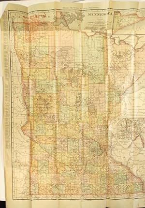
County map of Minnesota. Drawn and engraved by W. Gamble
Verlag: n.p., 1865
Anbieter: Rulon-Miller Books (ABAA / ILAB), St. Paul, MN, USA
Verbandsmitglied: ABAA ILAB RMABA
Verkäuferbewertung 5 von 5 Sternen
Handcolored map (388 x 309 mm.); displays different counties by color, woodcut border, a mostly fine copy.
-
Map of Wabasha County 1874 - from Illustrated Historical Atlas of the State of Minnesota
Verlag: A.T. Andreas, Chicago, 1874
Anbieter: William Chrisant & Sons, ABAA, ILAB. IOBA, ABA, Ephemera Society, Fort Lauderdale, FL, USA
Verbandsmitglied: ABAA ESA ILAB
Verkäuferbewertung 5 von 5 Sternen
Erstausgabe
Paper. Zustand: Very Good. First Edition. Hand-colored. From the "Illustrated Historical Atlas of the State of Minnesota". 14.5" x17.5". Maps of Lake City and Wabasha (city) to verso. Light foxing (see image). ; Oblong Folio; All shipments through USPS insured Priority Mail.
-
Map of Mower County 1874 - from Illustrated Historical Atlas of the State of Minnesota
Verlag: A.T. Andreas, Chicago, 1874
Anbieter: William Chrisant & Sons, ABAA, ILAB. IOBA, ABA, Ephemera Society, Fort Lauderdale, FL, USA
Verbandsmitglied: ABAA ESA ILAB
Verkäuferbewertung 5 von 5 Sternen
Erstausgabe
Paper. Zustand: Very Good. First Edition. Chicago: A.T. Andreas. Very Good. 1874. First Edition. Paper. Hand-colored. From the "Illustrated Historical Atlas of the State of Minnesota". 14" x 17.5". Maps of Blue Earth City, Wells, Winnebago and Dodge Center. Small tear near bottom right corner. Light foxing (see image). ; Oblong Folio; All shipments through USPS insured Priority Mail. .
-
Map of Winona County 1874 - Illustrated Historical Atlas of the State of Minnesota
Verlag: A.T. Andreas, Chicago, 1874
Anbieter: William Chrisant & Sons, ABAA, ILAB. IOBA, ABA, Ephemera Society, Fort Lauderdale, FL, USA
Verbandsmitglied: ABAA ESA ILAB
Verkäuferbewertung 5 von 5 Sternen
Erstausgabe
Paper. Zustand: Very Good. First Edition. Chicago: A.T. Andreas. Very Good. 1874. First Edition. Paper. From the "Illustrated Historical Atlas of the State of Minnesota". Soldier's Orphan's Home of Minnesota & Office of the Winona Republican. 28'' x 17.5". Lithographs of Wabasha & Winona Counties to verso side (see image). ; Oblong Folio; All shipments through USPS insured Priority Mail. .
-
![Bild des Verkäufers für Standard map of Chisago County, Minnesota, showing selected roads in red [cover title] zum Verkauf von Rulon-Miller Books (ABAA / ILAB)](https://pictures.abebooks.com/inventory/md/md10861691472.jpg)
Standard map of Chisago County, Minnesota, showing selected roads in red [cover title]
Verlag: McGill-Warner Co, St. Paul, 1920
Anbieter: Rulon-Miller Books (ABAA / ILAB), St. Paul, MN, USA
Verbandsmitglied: ABAA ILAB RMABA
Verkäuferbewertung 5 von 5 Sternen
One color map (approx. 648 x 521 mm.) folded down to approx. 178 x 114 mm. in brown printed wrappers; occasional tears from folds, else very good. Map title: "Standard map of Chisago County, Minnesota, showing portions of Isanti and Anoka Counties". University of Minnesota and Minnesota Historical Society only in OCLC.


