

Gesamtpreis (1 Artikel Artikel):
Versandziel:

china von arrowsmith (4 Ergebnisse)
Direkt zu den wichtigsten Suchergebnissen
Suchfilter
Produktart
- Alle Product Types
- Bücher (1)
- Magazine & Zeitschriften (Keine weiteren Ergebnisse entsprechen dieser Verfeinerung)
- Comics (Keine weiteren Ergebnisse entsprechen dieser Verfeinerung)
- Noten (Keine weiteren Ergebnisse entsprechen dieser Verfeinerung)
- Kunst, Grafik & Poster (Keine weiteren Ergebnisse entsprechen dieser Verfeinerung)
- Fotografien (Keine weiteren Ergebnisse entsprechen dieser Verfeinerung)
- Karten (3)
- Manuskripte & Papierantiquitäten (Keine weiteren Ergebnisse entsprechen dieser Verfeinerung)
Zustand Mehr dazu
- Neu (Keine weiteren Ergebnisse entsprechen dieser Verfeinerung)
- Wie Neu, Sehr Gut oder Gut Bis Sehr Gut (1)
- Gut oder Befriedigend (Keine weiteren Ergebnisse entsprechen dieser Verfeinerung)
- Ausreichend oder Schlecht (Keine weiteren Ergebnisse entsprechen dieser Verfeinerung)
- Wie beschrieben (3)
Einband
- alle Einbände
- Hardcover (Keine weiteren Ergebnisse entsprechen dieser Verfeinerung)
- Softcover (1)
Weitere Eigenschaften
- Erstausgabe (1)
- Signiert (Keine weiteren Ergebnisse entsprechen dieser Verfeinerung)
- Schutzumschlag (Keine weiteren Ergebnisse entsprechen dieser Verfeinerung)
- Angebotsfoto (4)
Sprache (1)
Preis
- Beliebiger Preis
- Weniger als EUR 20 (Keine weiteren Ergebnisse entsprechen dieser Verfeinerung)
- EUR 20 bis EUR 45 (Keine weiteren Ergebnisse entsprechen dieser Verfeinerung)
- Mehr als EUR 45
Gratisversand
- Kostenloser Versand nach USA (Keine weiteren Ergebnisse entsprechen dieser Verfeinerung)
Land des Verkäufers
Verkäuferbewertung
-

China. The Yang-Tsze Kiang, from Han-Kow to Ping-Shan; reduced from the large Chart (of which this is the Index) from the Survey of Captain T. Blakiston R.A.
Erscheinungsdatum: 1862
Anbieter: Geographicus Rare Antique Maps, Brooklyn, NY, USA
Verbandsmitglied: ABAA ESA ILAB
Verkäuferbewertung 4 von 5 Sternen

Karte
Very good. Exhibits light wear along original fold lines. Size 7.75 x 23.25 Inches. This is an 1862 John Arrowsmith map of the Yangtze River, China. Coverage extends from Hankou (Hankow) to Pingshan. The map follows 1861 Thomas Wright Blakiston (December 27, 1832 - October 15, 1891) Yangtze River Expedition. Blakiston's expedition traveled over 900 miles further up the river than any previous Western navigation. Blakiston also conducted detailed surveys of the Yangtze and produced a landmark map of the river. The present map acts as a key for Blakiston's larger map. Cities and towns of varying size are labeled throughout. Additional notations mark the now submerged Yangtze Gorges and other physical features. Publication History and Census This map was created by John Arrowsmith and published in the 1862 edition of The Journal of the Royal Geographical Society . An example is cataloged in OCLC and is part of the institutional collection at the National Library of Scotland. References: OCLC 316517087.
-
![Bild des Verkäufers für China [ Map of China including Korea and Tiawan and showing the routes of Lords Macartney and Amherst ] from The London Atlas of Universal Geography zum Verkauf von Keoghs Books](https://pictures.abebooks.com/inventory/md/md30987025439.jpg)
China [ Map of China including Korea and Tiawan and showing the routes of Lords Macartney and Amherst ] from The London Atlas of Universal Geography
Verlag: Published by J. Arrowsmith Feb. 1840, London, 1840
Anbieter: Keoghs Books, Skipton, Vereinigtes Königreich
Verbandsmitglied: PBFA
Verkäuferbewertung 5 von 5 Sternen

Karte Erstausgabe
EUR 298,65
EUR 32,47 Versand
Versand von Vereinigtes Königreich nach USAAnzahl: 1 verfügbar
In den Warenkorb, 50.5 x 62.5 cms colour map with central fold, approximately 90 miles to the inch, disbound from an early edition of The London Atlas of Universal Geography First Edition thus , map has one small very neatly repaired edge tear at each margin, otherwise near fine condition 50.5 x 62.5 cms Map ISBN:
-
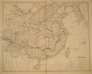
Map of China by John Arrowsmith, whose position in the Admiralty lead to the most recent discoveries being translated quickly to new information on his maps. 23 3/4 x 19 1/2". Original outline and wash color. Korea showed at the top right corners, as well as Taisan (Formosa) and the Loo Choo Islands. Published 15 Feby. 1832. Slt. darkening at fold o/w very good condition. HKD5800.
-

CHINA (by J. Arrowsmith, 1882)
Erscheinungsdatum: 1882
Karte
No Binding. Zustand: As New. Striking example of Arrowsmith's map of China and Korea. The map names Hong-Kong I. & Victoria City. The map appeared in Arrowsmith's London Atlas, one of the most popular English atlases of the mid-19th Century.


