Gesamtpreis (1 Artikel Artikel):
Versandziel:

chart mercators projection (47 Ergebnisse)
Direkt zu den wichtigsten Suchergebnissen
Suchfilter
Produktart
- Alle Product Types
- Bücher (20)
- Magazine & Zeitschriften (Keine weiteren Ergebnisse entsprechen dieser Verfeinerung)
- Comics (Keine weiteren Ergebnisse entsprechen dieser Verfeinerung)
- Noten (Keine weiteren Ergebnisse entsprechen dieser Verfeinerung)
- Kunst, Grafik & Poster (1)
- Fotografien (Keine weiteren Ergebnisse entsprechen dieser Verfeinerung)
- Karten (26)
- Manuskripte & Papierantiquitäten (Keine weiteren Ergebnisse entsprechen dieser Verfeinerung)
Zustand Mehr dazu
- Neu (6)
- Wie Neu, Sehr Gut oder Gut Bis Sehr Gut (5)
- Gut oder Befriedigend (6)
- Ausreichend oder Schlecht (Keine weiteren Ergebnisse entsprechen dieser Verfeinerung)
- Wie beschrieben (30)
Einband
Weitere Eigenschaften
- Erstausgabe (4)
- Signiert (1)
- Schutzumschlag (Keine weiteren Ergebnisse entsprechen dieser Verfeinerung)
- Angebotsfoto (41)
Sprache (3)
Gratisversand
Land des Verkäufers
Verkäuferbewertung
-

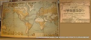
A New and Accurate Method of Finding a Ship's Position at Sea, by Projection On Mercator's Chart ...: The Principles of the Method Being Fully ... for Practice, and Examples From Actual O
Anbieter: Ria Christie Collections, Uxbridge, Vereinigtes Königreich
Verkäuferbewertung 5 von 5 Sternen

EUR 17,63
EUR 13,87 Versand
Versand von Vereinigtes Königreich nach USAAnzahl: Mehr als 20 verfügbar
In den WarenkorbZustand: New. In.
-

A New and Accurate Method of Finding a Ship's Position at Sea, by Projection On Mercator's Chart ...: The Principles of the Method Being Fully ... for Practice, and Examples From Actual O
Anbieter: Ria Christie Collections, Uxbridge, Vereinigtes Königreich
Verkäuferbewertung 5 von 5 Sternen
EUR 31,03
EUR 13,87 Versand
Versand von Vereinigtes Königreich nach USAAnzahl: Mehr als 20 verfügbar
In den WarenkorbZustand: New. In.
-

A New and Accurate Method of Finding a Ship's Position at Sea, by Projection On Mercator's Chart .: The Principles of the Method Being Fully Explain
Sprache: Englisch
Verlag: Creative Media Partners, LLC Okt 2022, 2022
ISBN 10: 1016043481 ISBN 13: 9781016043489
Anbieter: AHA-BUCH GmbH, Einbeck, Deutschland
Verkäuferbewertung 5 von 5 Sternen
Taschenbuch. Zustand: Neu. Neuware.
-

Taschenbuch. Zustand: Neu. A New and Accurate Method of Finding a Ship's Position At Sea, By Projection On Mercator's Chart | Sumner Thomas Hubbard | Taschenbuch | Englisch | 2025 | Antigonos Verlag | EAN 9783563809839 | Verantwortliche Person für die EU: preigu GmbH & Co. KG, Lengericher Landstr. 19, 49078 Osnabrück, mail[at]preigu[dot]de | Anbieter: preigu.
-

Taschenbuch. Zustand: Neu. A New and Accurate Method of Finding a Ship's Position at Sea by Projection on Mercator's Chart | Thomas H. Sumner | Taschenbuch | Englisch | 2025 | Antigonos Verlag | EAN 9783563810590 | Verantwortliche Person für die EU: preigu GmbH & Co. KG, Lengericher Landstr. 19, 49078 Osnabrück, mail[at]preigu[dot]de | Anbieter: preigu.
-

A New and Accurate Method of Finding a Ship's Position at Sea, by Projection On Mercator's Chart .: The Principles of the Method Being Fully Explain
Sprache: Englisch
Verlag: Creative Media Partners, LLC Okt 2022, 2022
ISBN 10: 1016033168 ISBN 13: 9781016033169
Anbieter: AHA-BUCH GmbH, Einbeck, Deutschland
Verkäuferbewertung 5 von 5 Sternen
Buch. Zustand: Neu. Neuware.
-

National Geographic Magazine - February 1905 - Volume XVI, No. 2 "Chart of the World on Mercator's Projection"; "Russia"; "Marine Hydrographic Surveys of the Coasts of the World"
Verlag: National Geographic Society, 1905
Anbieter: Visible Voice Books, Cleveland, OH, USA
Verkäuferbewertung 5 von 5 Sternen
paperback. Zustand: Good. National Geographic Society Staplebound magazine. Spot of wax on front cover. Slight slice to front cover and early pages but not hindering readability. Mild staining to very margin of several pages. Secure binding.
-

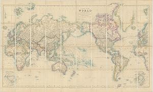
A New Chart of the World on Mercator's Projection with the Tracks of the Most Celebrated and Recent Navigators.
Verlag: LondonHenry Teesdale ., 1845
Anbieter: Robert Frew Ltd. ABA ILAB, London, Vereinigtes Königreich
Verbandsmitglied: ABA ILAB PBFA
Verkäuferbewertung 5 von 5 Sternen
Karte
EUR 6.857,48
EUR 11,58 Versand
Versand von Vereinigtes Königreich nach USAAnzahl: 1 verfügbar
In den WarenkorbOriginal large-format map of the world on Mercator's projection (130 x 198 cm), engraved by John Dower and with fine original colour, sectionalised and laid onto two sections of linen as issued, each edged with green silk and measuring 130 x 99 cm, folding between publisher's original morocco covers (38 x 27 cm) with gilt foliate frame enclosing gilt title, marbled endpapers. Some very faint occasional foxing, upper cover with scratch mark to lower centre, overall a particularly fine example of this impressive map. Fine large format map of the world, which provides fantastic detail throughout, engraved by John Dower and published by Henry Teesdale. It is one of the few English maps to recognise the Republic of Texas (England itself did not), and depict its most ambitious boundaries. It is also the most complete map to show a complete northwest passage following the Deese-Simpson Expedition. Perhaps the most interesting part of the map is its treatment of the search for the Northwest Passage and the extensive annotations showing the routes of various discoverers throughout the world. With respect to the Northwest Passage, there are dozens of annotations identifying the British and other discoveries in the region, with section of text describing Arctic exploration up to 1833 and then additional notes on the map discussing discoveries up to October 1839, noting: "This Coast was Explored by Messrs. Dease and Simpson under the Honble. Hudson's Bay Company which completes the North West Passage Octr. 1839" Off the coast of Alaska, a number of different tracks of exploration are shown, up to Captain Beechey in 1826, with a further note in the interior further discussing P.W. Deawe and Thos. Simpson's expedition beginning at Fort Chipewyan June 1, 1837, traveling north to the Arctic Sea and then to Alaska. In the Southern Hemisphere, there are a number of early Antarctic discoveries shown. Teesdale was a London-based map publisher. He was an early Fellow of the Royal Geographical Society, elected in 1830. Teesdale partnered with John Hordan and William Colling Hodson, but this arrangement dissolved in 1832. Afterward, he continued to work on his own and periodically with colleagues like John Crane Dower, Christopher Greenwood, Josiah Henshall and others. He published a variety of atlases and separately-issued maps. His business was quite successful, as he registered as a partner in the Royal Bank of Scotland in 1845.
-
Bartholomew's Library Chart of the World on Mercator's Projection
Verlag: George Philip & Son, London, 1870
Anbieter: Michael Treloar Booksellers ANZAAB/ILAB, Adelaide, SA, Australien
Verkäuferbewertung 5 von 5 Sternen
Karte Erstausgabe
Hardcover. Zustand: Near fine. First Edition. London, George Philip & Son, [late 1870s]. Approximately 1420 × 1880 mm (printed surface), comprising eight sheets printed in colour (printed surface approximately 710 × 470 mm each), each comprising two panels mounted as a pair on linen, with its respective portion of the key map mounted on the verso. The maps are neatly scored along the inner borders so that the margins can be folded under and the sheets laid together seamlessly (as issued). One crease and surface crack to the top corner of Sheet 8 (clear of the printed surface); a few trifling marks; in near-fine condition, housed in the original presentation portfolio of half red roan and morocco-grain cloth, elaborately blocked in gilt (covers a little worn, with splits to the spine expertly stabilised). There are four inset maps in the bottom half: the two hemispheres; winds; heights and depths; and natural productions. An elaborate gilt-lettered blue morocco presentation label is mounted on one of the flaps of the portfolio; it reads: 'Presented to Mr. W. Whittam by the employés of Harrold Brothers, Adelaide, 31st March, 1882'.
-

Chart of the World on Mercator's Projection. Entirely Reconstructed by Hermann Habenicht (for the sea) and Bruno Domann (for the land). XIIth Edition.
Verlag: GothaJustus Perthes ., 1897
Anbieter: Robert Frew Ltd. ABA ILAB, London, Vereinigtes Königreich
Verbandsmitglied: ABA ILAB PBFA
Verkäuferbewertung 5 von 5 Sternen
Karte
EUR 1.788,91
EUR 11,58 Versand
Versand von Vereinigtes Königreich nach USAAnzahl: 1 verfügbar
In den WarenkorbLarge folding chart of the world (overall dimensions 97 x 148 cm). The sea with full colour, original outline colour to territorial borders and coastlines. Numerous geographical and commercial references highlighted in original colour including sailing routes, telegraph lines and ocean currents. Vignette world charts to the lower corners outlining the locations of telegraph lines and the courses of the prevailing winds. Another panel to the centre of the lower edge with twin hemisphere projections. One panel of general explanatory text, another panel of text outlining the principal steamship routes. The whole dissected into 32 sections and backed onto linen, housed in publisher's original green cloth slipcase. A superb example.
-

A Chart of the World on Mercator's Projection Shewing the principal Ocean Steam Routes, the Submarine Telegraphs &c.
Verlag: LondonEdward Stanford 55 Charing Cross Jan. 1st ., 1885
Anbieter: Robert Frew Ltd. ABA ILAB, London, Vereinigtes Königreich
Verbandsmitglied: ABA ILAB PBFA
Verkäuferbewertung 5 von 5 Sternen
Karte
EUR 1.132,98
EUR 11,58 Versand
Versand von Vereinigtes Königreich nach USAAnzahl: 1 verfügbar
In den WarenkorbOriginal engraved map of the world (69.5 x 103.5 cm) with outline colour, dissected into 40 panels and laid onto linen, two panels with marbled endpapers, folding into original brown cloth slipcase with publisher's yellow title label to upper portion. The map recording steam routes including travel times and underwater telegraph cables; map inserts of the Arctic and Antarctica (polar projection) in lower right and lower left quadrants. Generally an excellent, well preserved copy. Edward Stanford, Fellow of the Royal Geographical Society, acquired the plates and stock of John Arrowsmith in 1874.
-
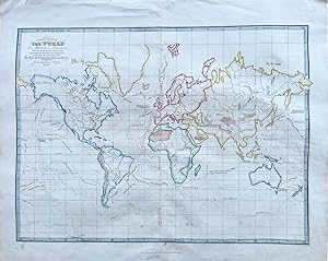
![Bild des Verkäufers für Bartholomew's Chart of the World on Mercator's Projection. [Cover Title:] Bartholomew's Commercial Chart of the World. zum Verkauf von Robert Frew Ltd. ABA ILAB](https://pictures.abebooks.com/inventory/md/md31703176818.jpg)
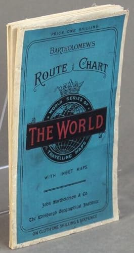
Bartholomew's Chart of the World on Mercator's Projection. [Cover Title:] Bartholomew's Commercial Chart of the World.
Verlag: Published at the Edinburgh Geographical Institute by John Bartholomew & Son Ltd. c., 1920
Anbieter: Robert Frew Ltd. ABA ILAB, London, Vereinigtes Königreich
Verbandsmitglied: ABA ILAB PBFA
Verkäuferbewertung 5 von 5 Sternen
Karte
EUR 2.087,06
EUR 11,58 Versand
Versand von Vereinigtes Königreich nach USAAnzahl: 1 verfügbar
In den WarenkorbVery large original colour-printed chart of the world on Mercator's projection (overall 115 x 182 cm), dissected into 36 sections and mounted onto cloth as issued, folding between original publisher's paper covers. Four brass ringed eyelets for hanging to the upper portion. Twin polar inset maps to lower corner, the British colonies shaded in pink, the chart showing the currents of the ocean and a plethora of shipping routes. Generally an excellent copy.
-
A Chart of the World on Mercator's Projection Shewing the principal Ocean Steam Routes, the Submarine Telegraphs &c.
Verlag: LondonEdward Stanford 55 Charing Cross June 1st ., 1881
Anbieter: Robert Frew Ltd. ABA ILAB, London, Vereinigtes Königreich
Verbandsmitglied: ABA ILAB PBFA
Verkäuferbewertung 5 von 5 Sternen
Karte
EUR 1.490,76
EUR 11,58 Versand
Versand von Vereinigtes Königreich nach USAAnzahl: 1 verfügbar
In den WarenkorbOriginal engraved map of the world (69.5 x 103.5 cm) with outline colour, dissected into 40 panels and laid onto linen, two panels with marbled endpapers, folding into original brown cloth slipcase with publisher's yellow title label to upper portion. The map recording steam routes including travel times and underwater telegraph cables; map inserts of the Arctic and Antarctica (polar projection) in lower right and lower left quadrants. Some occasional light soiling, generally an excellent example. Edward Stanford, Fellow of the Royal Geographical Society, acquired the plates and stock of John Arrowsmith in 1874.
-

A Chart of the World on Mercator's Projection Shewing the Principal Ocean Steam Routes, the Submarine Telegraph &c
Verlag: Edward Stanford, London, 1881
Karte
No binding. Zustand: Very good. London: Edward Stanford, 1881. Engraved case map of the world in 40 segments (26 ˝ x 44 ľ inches) mounted to original linen backing with promotional self-wrappers ("Stanford's Two-Shilling Series of Tourists Guides / New Maps and New Editions"), recording steam routes including travel times and underwater telegraph cables; map inserts of the Arctic and Antarctica (polar projection) in lower right and lower left quadrants. Condition: very good with original color in outline; small creasing in lower right corner and some isolated foxing. Edward Stanford, Fellow of the Royal Geographical Society, acquired the plates and stock of John Arrowsmith in 1874. Note some scattered annotations regarding the achievements of 19th century naval officers and explorers that Stanford added to the present map, including the mention of William Parry's (1790-1855) attempt on the North Pole from the northern shores of Spitsbergen in 1827 (recorded beyond the neatline of the present map).
-
WORLD MAP- 1879 // Chart of the world on Mercators projection : containing the lines of oceanic mail steam communication and overland routes, the international aerial and submarine telegraphs, and the principal tracks of sailing vessels, showing some continental surface characteristics, the oceanic currents and important deep-sea soundings, with 33 additional charts and plans showing the general currents of air, and the lines of equal magnetic variation, the Tehuantepec, Honduras, Nicaragua, Panama, Darien, and Suez routes, several sea ports, the telegraphic and steam lines round the world = Chart of the world zur Übersicht der regelmässigen Dampfschifffahrts-Linien und Überland-Routen, der internationalen Land- und Untersee-Telegraphen, sowie der wichtigeren Segelschiffswege, der Bodenbeschaffenheit, der See-Strömungen und neuerer Tiefsee-Messungen, mit 33 Nebenkarten zur Darstellung der Haupt-Windrichtungen und der Linien gleicher magnetischer Missweisung, der Landengen von Tehuantep
Verlag: Perthes, Gotha, 1879
Anbieter: ANTIQUARIAT.WIEN Fine Books & Prints, Wien, Österreich
Verkäuferbewertung 5 von 5 Sternen
Karte
9th edition, original Lithograph / 9. Auflage original Lithographie zu 8 Segmenten auf Leinen gezogen, Gesamtformat ca. 155 x 97 cm; Zustand: gut Weltkarte von Hermann Beghaus (1828-1890) Neffe und Schüler von Heinrich Berghaus. Nephew and pupil of Heinrich Berghaus; und Friedrich v. Stülpnagel (1786-1865) Tooley I, 125, IV, 231 de 350 Landkarte.
-
A New Chart of the World on Mercator's Projection, with the Tracks of the Most Celebrated Recent Navigators.
Verlag: London: Henry Teesdale, 1842., 1842
Anbieter: Arader Galleries - AraderNYC, New York, NY, USA
Verkäuferbewertung 5 von 5 Sternen
Signiert
Hardcover. Zustand: Very Good. Large folding engraved wall map two separate sheets (each 51 x 38 4/8 inches), each laid down on cartographic linen in 16 sections, with original hand-colour in full, showing the tracks of major explorers from Tasman to Briscoe, compass roses, a table of Explanation of bearings and distances, and a table of Distances, both lower right, edged in green silk (a bit browned at folds, some loss to edging). A fine large wall map showing the tracks of the major explorers to the mid 1830s, with other interesting and important events noted. British recognition of the Republic of Texas in November of 1840 is recorded, although James Hamilton was only able to agree three treaties with the British at this stage. These were related to commerce and navigation, a second provided for British mediation in the Texas-Mexico difficulties concerning peace, and a third called for the suppression of slave trade, and though signed in November 1840, because of various delays ratifications were not actually exchanged until July 28, 1842. The new boundary between the British Possessions in North America and the United States which was only decided as recently as April of 1842 with the signing of the Webster-Ashburton Treaty is recorded. "This treaty settled many long-standing issues between the United States and England that by 1842 had become acute. These included U.S.-Canadian boundary disputes; the 1837 burning by Canadians of a U.S. steamship, the Caroline, in the Niagara River, with the death of a crewman; the 1840 arrest in New York State of a Canadian, Alexander McLeod, accused of involvement in the Caroline affair; and the refusal of British authorities to return to the United States the African-American slaves who in 1841 had seized and diverted to the Bahamas a U.S. brig, the Creole, transporting them from Virginia to New Orleans.The Webster-Ashburton Treaty granted the United States nearly 60 percent of the disputed area in the Northeast, including a strategic military location at the top of Lake Champlain, along with a region west of Lake Superior, Minnesota's Mesabi Range, that later proved rich in iron ore. It also allowed Americans to turn westward and encouraged what proved to be an enduring Anglo-American rapprochement". Joseph W. Schmitz for Texas State Historical Association online. Signed by Author(s).
-

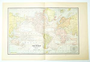
Bartholomew's Library Chart of the World on Mercators Projection
Verlag: George Philip & Son, London, Liverpool, 1878
Anbieter: Alexandre Antique Prints, Maps & Books, Toronto, ON, Kanada
Verkäuferbewertung 5 von 5 Sternen
Karte
This is a large scale impressive world map within a decorative engraved foliage boarder. A large cartouche with information within, an inset of the Southern and Northern Hemisphere is in the upper left, a chart of the north pole is in the upper right. Along the lower portion of the map appears inset charts depicting natural productions of the world, heights and depths, and finally, winds and hydrographic basinsDisected into 8 individually folding sheets. Within a contemporary full cloth red folio with title in gilt on upper board., Size : 1420x1880 (mm), 55.875x74 (Inches), Printed in Color Excellent, laid on original canvas.
-
Travellers' route chart of the world on Mercators projection. By J.G. Bartholomew, F.R.G.S.
Verlag: John Bartholomew & Co., The Edinburgh Geographical Institute, Edinburgh, 1896
Anbieter: Rulon-Miller Books (ABAA / ILAB), St. Paul, MN, USA
Verbandsmitglied: ABAA ILAB RMABA
Verkäuferbewertung 5 von 5 Sternen
Folding map of the world approx. 20" x 29", linen-backed, as issued, and folding down to an octavo with blue labels on front and back printed in black and red. The map was available with or without the linen backing. With 13 inset charts of the principal ports of the world. BL only in OCLC.
-
'A CHART OF THE WORLD ON MERCATOR'S PROJECTION SHEWING THE PRINCIPAL OCEAN STEAM ROUTES, THE SUBMARINE TELEGRAPHS &C.'. Map of the British Empire, printed on two sheets, with circular insets of North and South Pole
Verlag: Edward Stanford, London ca. 1900, 1900
Anbieter: Garwood & Voigt, Sevenoaks, Vereinigtes Königreich
Verkäuferbewertung 5 von 5 Sternen
Karte
EUR 137,15
EUR 34,74 Versand
Versand von Vereinigtes Königreich nach USAAnzahl: 1 verfügbar
In den Warenkorb61x107cm when joined. Printed in full colours. Excellent condition.
-
1889 Color Chart (Map) of the World on Mercator's Projection
Verlag: W.H. Stewart, Rochester, NY, 1889
Anbieter: RareNonFiction, IOBA, Ladysmith, BC, Kanada
Verbandsmitglied: IOBA
Verkäuferbewertung 5 von 5 Sternen
Map. Zustand: Very Good. Cram, Geo. F. (illustrator). First Edition Thus. Outer dimensions: 21.75" x 14.5". Ocean currents indicated. Clean and unmarked with light wear. A quality vintage copy.
-

"CHART OF THE WORLD ON MERCATORS PROJECTION". Showing the direction of the Ocean Currents with the Routes and Distances between the Principal Ports.
Verlag: W. & A.K. Johnston ca 1850, 1850
Anbieter: Garwood & Voigt, Sevenoaks, Vereinigtes Königreich
Verkäuferbewertung 5 von 5 Sternen
Karte
EUR 208,71
EUR 34,74 Versand
Versand von Vereinigtes Königreich nach USAAnzahl: 1 verfügbar
In den WarenkorbNo Binding. Zustand: Fine. Original colour. 44 x 57 cm.
-
Chart of the World on Mercators Projection
Verlag: c.1860, Edinburgh, 1860
Anbieter: Alexandre Antique Prints, Maps & Books, Toronto, ON, Kanada
Verkäuferbewertung 5 von 5 Sternen
Karte
Zustand: Very Good, age tonned. An attractive mid-19th century map of the World with commercial shipping lines and explorer's paths., Size : 440x572 (mm), 17.32x22.52 (Inches), Printed in Color with Some Hand Coloring.
-
A Plane Chart of the World on Mercator's Projection. With the Tracks & Discoveries of the Principal and Most Recent Navigators; for the Elucidation of The AbbĂ Gaultier's Geographical Games.
Verlag: John Harris, 1838., 1838
Anbieter: Michael S. Kemp, Bookseller, Sheerness, KENT, Vereinigtes Königreich
Verbandsmitglied: PBFA
Verkäuferbewertung 5 von 5 Sternen
Karte
EUR 293,86
EUR 46,31 Versand
Versand von Vereinigtes Königreich nach USAAnzahl: 1 verfügbar
In den WarenkorbEngraved map with contemporary outline hand colouring, 400 x 470 mm. with central fold and a few closed tears to the blank border. Most commonly seen as a double hemisphere map, this is a similar map to that used by Harris for his various jigsaws and board games. Gaultier was a French educationalist who fled the Revolution, settling in England; he believed in teaching geography by the use of games.
-
'A CHART OF THE WORLD ON MERCATOR'S PROJECTION'. Large world map showing the British Empire, printed on two sheets
Verlag: Edward Stanford ca. 1900, 1900
Anbieter: Garwood & Voigt, Sevenoaks, Vereinigtes Königreich
Verkäuferbewertung 5 von 5 Sternen
Karte
EUR 333,93
EUR 34,74 Versand
Versand von Vereinigtes Königreich nach USAAnzahl: 1 verfügbar
In den Warenkorb106x61cm when joined. Full original colour. Excellent condition.
-

Hydrographical Chart Of The World On Wright Or Mercators Projection With Tracks Of The Last Circumnavigators From 'A New General Atlas, consisting of A Series of Geographical Designs, on Various Projections, Exhibiting the Form and Component Parts of the Globe; and A Collection of Maps and Charts, Delineating the Natural and Political Divisions of the Empires, Kingdoms and States of the World'.
Verlag: John Thomson & Company, Edinburgh, UK, 1814
Anbieter: Hornseys, Ripon, Vereinigtes Königreich
Verbandsmitglied: PBFA
Verkäuferbewertung 5 von 5 Sternen
EUR 351,82
EUR 28,95 Versand
Versand von Vereinigtes Königreich nach USAAnzahl: 1 verfügbar
In den WarenkorbNo Binding. Zustand: Very Good. Sheet size: 68cm x 53.8cm. From 'A New General Atlas, consisting of A Series of Geographical Designs, on Various Projections, Exhibiting the Form and Component Parts of the Globe; and A Collection of Maps and Charts, Delineating the Natural and Political Divisions of the Empires, Kingdoms and States of the World'. Date c.1814-1816. Crease to central fold line with a short split to the margin. Blank to the reverse. Age-toning, especially to the margins, minor off-setting and slight foxing as usual. Original hand-colouring nice and bright. In very good, bright, clean condition. This is one of a number of these maps that e are currently posting. Please see our other listings or use the keyword: hornseysthomson.
-
'CHART OF THE WORLD ON MERCATOR'S PROJECTION'. Map of the world, printed on two double sheets, not joined. Numerous tracks of explorers (Cook etc.) are shown
Verlag: William Lizars ca. 1845, 1845
Anbieter: Garwood & Voigt, Sevenoaks, Vereinigtes Königreich
Verkäuferbewertung 5 von 5 Sternen
Karte
EUR 429,34
EUR 34,74 Versand
Versand von Vereinigtes Königreich nach USAAnzahl: 1 verfügbar
In den Warenkorb53x80cm when joined. Original outline colour. Excellent condition. The two map sheets together.
-

A Plane Chart of the World on Mercator's Projection, for the elucidation of The Abbe Gaultier's Geographical Games.
Verlag: John Harris, St Paul's Church Yard,
Anbieter: Daniel Crouch Rare Books Ltd, London, Vereinigtes Königreich
Verbandsmitglied: ABA ILAB PBFA
Verkäuferbewertung 5 von 5 Sternen
Karte
EUR 536,67
EUR 23,16 Versand
Versand von Vereinigtes Königreich nach USAAnzahl: 1 verfügbar
In den WarenkorbA game plan for the whole world Double-page engraved chart, with contemporary hand-colour in outline. The tracks of the major explorations of the late eighteenth century are shown, and those of the early decades of the nineteenth, including that of Lieutenant W. E. Parry on the first voyage of the 'Hecla' in search of the Northwest Passage, in 1819. Published in 'An atlas adapted to the Abbe Gaultier's geographical games consisting of a set of maps coloured, and also another set containing merely the outlines of kingdoms and provinces, with the course of rivers, and the situation of the principal towns, islands, mountains, &c. &c' (1832-1838). Provenance Freycinet family archives NLA Bib ID: 1192659.
-
A Chart of the World on Mercator's Projection, Shewing the Principal Ocean Steam Routes, The Submarine Telegraphs, &c
Verlag: London, 1885
Anbieter: Argosy Book Store, ABAA, ILAB, New York, NY, USA
Verkäuferbewertung 5 von 5 Sternen
Case Map. Lithograph. Sheet measures 44 1/4" x 27 5/8". Comes with brown slip case that measures 4 3/4" x 7". Wonderful world map centered on the Pacific Ocean, highlighting steam ship routes. The western most countries of Europe and Africa appear on both the left right and right sides of the composition in order to show the steam ship routes and undersea telegraph cables in their entirety. Two inset maps in the bottom corners show the Arctic and Antarctic regions. Edward Stanford (1827-1904) was an English mapmaker and publisher, and the founder of a map and globe company that still flourishes today. After a brief partnership with T.W. Saunders as Saunders & Stanford from 1852-1853, Stanford established his own firm by 1854. Collaborating with his former partner Saunders, and the Edinburgh publishing family of A.K. Johnston, he grew to become one of the major map and atlas compilers of the 19th century, using maps acquired from the Society for the Diffusion of Knowledge, and later from John Arrowsmith among other sources. Many of his publications were for official bodies such as the Ordnance Survey, Admiralty, Geological Survey, Trigonometrical Survey of India, the Royal Geographical Society, the School Board of London, and many more. In the 1880s, his son Edward Jr. took over leadership of the firm. Stanfords still exists today in London and Bristol, and its collection of maps, globes, and maritime charts is considered the largest in the world.
-
Chart of the World on Mercator's Projection
Verlag: Typographic Etching Company, London, 1880
Anbieter: Argosy Book Store, ABAA, ILAB, New York, NY, USA
Verkäuferbewertung 5 von 5 Sternen
Typographic etching, Sheet measures 19 3/4 x 28". Uncommon facsimile map issued by the Hakluyt Society, named after Richard Hakluyt (1552-1616), the influential English geographer and compiler of travel accounts. This map reproduces the Wright-Molyneux world chart, originally published in 1599 and derived from a 1592 globe by English globe maker Emeric Molyneux. The map first appeared in Edward Wrights seminal work, 'Certaine Errors in Navigation', which for the first time clearly articulated the mathematical foundations of the Mercator projection. Notably minimalist, the chart omits details for unexplored regions, leaving them blank. An early reference to the Great Lakes appears as Lake Tadouac. A decorative cartouche in the upper left bears the royal motto Dieu et mon droit 'God and my right' used by Queen Elizabeth I and later British monarchs (excluding those in Scotland). Curious details include the upside-down engraving of Estotiland, a legendary island from the apocryphal voyage of the Zeno brothers, and an early use of the name Canada, echoing its appearance on Forlani's 1560 Italian map. Condition: Even overall toning with light creasing; otherwise in very good condition. Provenance: from the collection of Polish artist Stanislaw Szukalski.
-

A New Generall Chart of the Coast of Guinea and Brasil From C. Virde to C. de Bona Esperance, And from the River of Amazons to Rio de la Plata, &c, of Ed. Wright's projection vut Mercator's Chart.
Verlag: Ier. Seller and Cha. Price At the Hermitage Staires,
Anbieter: Daniel Crouch Rare Books Ltd, London, Vereinigtes Königreich
Verbandsmitglied: ABA ILAB PBFA
Verkäuferbewertung 5 von 5 Sternen
Karte
EUR 2.385,21
EUR 23,16 Versand
Versand von Vereinigtes Königreich nach USAAnzahl: 1 verfügbar
In den WarenkorbSeller and Price's extremely rare chart of the Southern Atlantic Engraved chart with original hand colour, heightened in gold. A chart of the South Atlantic, from Jeremiah Seller and Charles Price's extremely rare 'The English Neptune or, A New Sea Atlas.', published in 1704. The brief partnership of Price and Seller, survived until 1705, when the partnership went bankrupt (not for the first time in Price's life). One of the partnership's major publications was the 'English Neptune.'. Alas the atlas was clearly not a commercial success, as we are only aware of one institutional example (Yale University Library), which as well as the 13 charts by Price and Seller contains a further 16 charts by Herman Moll, and Thomas Mount and Richard Page. The presence of other cartographer's charts would suggest that the atlas was, most likely, formed after the partnership went bankrupt in 1705. Further weight to this argument is that when one looks at the only example appearing at auction, which contained 18 charts, 13 were by Seller and Price, and five by Herman Moll. Charles Price (1679-1733) was apprenticed to John Seller (1632-1697), the father of English sea atlas publishing, in February 1694. He was made free of the Merchant Taylors' Guild on 1 September 1703, on the same day as John Seller's son Jeremiah Seller. He worked in partnership with Jeremiah Seller (1700-1705), with John Senex (1705-1710), with George Wildey (1710-1713), and with instrument maker Benjamin Scott (1715-1718). In 1727, he announced that work would begin on "a general atlas for sea and land". In 1729, on his chart of the English Channel, he advertised for 'A Compleat Sea Atlas", which would cover the whole world and contain some 250 charts. Only 31 charts are known to have been published by Price before he was confined to the Fleet Prison for debt in December 1731. He continued to advertise his work at a reduced price "for ready money. ill fortune and ill usage has constrain'd me to sell my goods at this cheap rate". He died early in 1733, leaving his stock equally to his son Charles, his daughter Ann, and his wife Elizabeth. Individual charts from the atlas are particularly rare on the market. We are unaware of any example of the present map appearing at auction in the last 30 years. We have only been able to trace 1 institutional example: The Israel National Library.