

Gesamtpreis (1 Artikel Artikel):
Versandziel:

brussels von society diffusion useful knowledge (5 Ergebnisse)
Direkt zu den wichtigsten Suchergebnissen
Suchfilter
Produktart
- Alle Product Types
- Bücher (4)
- Magazine & Zeitschriften (Keine weiteren Ergebnisse entsprechen dieser Verfeinerung)
- Comics (Keine weiteren Ergebnisse entsprechen dieser Verfeinerung)
- Noten (Keine weiteren Ergebnisse entsprechen dieser Verfeinerung)
- Kunst, Grafik & Poster (Keine weiteren Ergebnisse entsprechen dieser Verfeinerung)
- Fotografien (Keine weiteren Ergebnisse entsprechen dieser Verfeinerung)
- Karten (1)
- Manuskripte & Papierantiquitäten (Keine weiteren Ergebnisse entsprechen dieser Verfeinerung)
Zustand Mehr dazu
- Neu (Keine weiteren Ergebnisse entsprechen dieser Verfeinerung)
- Wie Neu, Sehr Gut oder Gut Bis Sehr Gut (Keine weiteren Ergebnisse entsprechen dieser Verfeinerung)
- Gut oder Befriedigend (1)
- Ausreichend oder Schlecht (Keine weiteren Ergebnisse entsprechen dieser Verfeinerung)
- Wie beschrieben (4)
Einband
- alle Einbände
- Hardcover (Keine weiteren Ergebnisse entsprechen dieser Verfeinerung)
- Softcover (Keine weiteren Ergebnisse entsprechen dieser Verfeinerung)
Weitere Eigenschaften
- Erstausgabe (Keine weiteren Ergebnisse entsprechen dieser Verfeinerung)
- Signiert (Keine weiteren Ergebnisse entsprechen dieser Verfeinerung)
- Schutzumschlag (Keine weiteren Ergebnisse entsprechen dieser Verfeinerung)
- Angebotsfoto (5)
Sprache (1)
Preis
- Beliebiger Preis
- Weniger als EUR 20 (Keine weiteren Ergebnisse entsprechen dieser Verfeinerung)
- EUR 20 bis EUR 45 (Keine weiteren Ergebnisse entsprechen dieser Verfeinerung)
- Mehr als EUR 45
Gratisversand
- Kostenloser Versand nach USA (Keine weiteren Ergebnisse entsprechen dieser Verfeinerung)
Land des Verkäufers
Verkäuferbewertung
-

Brussels (Bruxelles).
Verlag: London, Chas. Knight, [1844]. 335 x 385mm (13¼ x 15¼ inches)., 1844
Anbieter: Tooley, Adams & Co., Wallingford, OXON, Vereinigtes Königreich
Verkäuferbewertung 3 von 5 Sternen

EUR 54,67
EUR 42,87 Versand
Versand von Vereinigtes Königreich nach USAAnzahl: 1 verfügbar
In den WarenkorbOriginal outline colour; light age-toning to the edges of the margins, otherwise a fine example. A Victorian detailed plan of the city, drawn by W.B.Clarke and engraved by B.R.Davies, with the important buildings in profile along the bottom. From the 1844 edition published by Chas. Knight for The Society for the Diffusion of Useful Knowledge.
-

Brussels (Bruxelles).
Verlag: London, Thomas Letts, [1877]. 335 x 385mm (13¼ x 15¼ inches)., 1877
Anbieter: Tooley, Adams & Co., Wallingford, OXON, Vereinigtes Königreich
Verkäuferbewertung 3 von 5 Sternen
EUR 57,05
EUR 42,87 Versand
Versand von Vereinigtes Königreich nach USAAnzahl: 1 verfügbar
In den WarenkorbOriginal outline colour; light age-toning to the edges of the margins, otherwise a fine example. A Victorian detailed plan of the city, drawn by W.B.Clarke and engraved by B.R.Davies, with the important buildings in profile along the bottom. From the 1877 edition published by Thomas Letts for The Society for the Diffusion of Useful Knowledge.
-

Brussels; (Bruxelles)
Verlag: Charles Knight, London, 1847
Anbieter: Argosy Book Store, ABAA, ILAB, New York, NY, USA
Verkäuferbewertung 5 von 5 Sternen

unbound. W. B. Clarke; R.R. Davies (illustrator). Map. Engraving with hand coloring. Image measures 13 1/4" x 15" Beautifully detailed town plan of Brussels, Belgium with north oriented toward the right margin. Features a impressive aerial view of the city's grid plan, showing buildings and gardens, with streets, plazas, and major landmarks labeled, and parks and waterways accented by hand coloring. An inset in the lower left depicts the Environs of Brussels, with villages and major roads labeled. Along the bottom is a "Comparison of the Principal Buildings in Brussels", with eight buildings illustrated. William Barnard Clarke (1806-1865) was an English architect, cartographer, archeological writer and art collector. He was the founding president of the Architectural Society of London. The "Society for the Diffusion of Useful Knowledge" (SDUK), founded in 1826 at the initiative of British lord Henry Peter Brougham, aimed to distribute affordable, high-quality educational materials to the working and middle classes. Despite ties to prestigious publishers like Baldwin and Cradock, Chapman and Hall, and Charles Knight, SDUK closed in 1848 due to financial challenges. It achieved renown for its exceptional atlases, notably a comprehensive series of maps initially issued individually and later consolidated into a groundbreaking world atlas under Chapman and Hall. SDUK maps are celebrated for their accuracy, detail, and accessibility, representing a pinnacle of 19th-century English mass-market cartography.
-

Brussels
Verlag: London. 1847, 1847
Anbieter: Peter Harrington. ABA/ ILAB., London, Vereinigtes Königreich
Verbandsmitglied: ABA ILAB PBFA
Verkäuferbewertung 5 von 5 Sternen
EUR 231,75
EUR 25,39 Versand
Versand von Vereinigtes Königreich nach USAAnzahl: 1 verfügbar
In den WarenkorbA very precise and detailed map of the Belgian capital. There is a small inset map of the environs of Brussels, and running along the base of the plan are numerous elevations of the main public buildings. Published by Charles Knight for the S.D.U.K. Size: 350 x 435 mm. Steel engraving with original outline colour. Good condition, minor ager toning and staining.
-
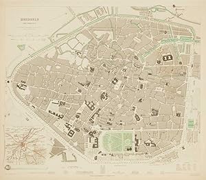
Brussels (Bruxelles).
Erscheinungsdatum: 1837
Anbieter: Altea Antique Maps, London, Vereinigtes Königreich
Verbandsmitglied: ABA ILAB PBFA
Verkäuferbewertung 5 von 5 Sternen
Karte
EUR 71,31
EUR 40,39 Versand
Versand von Vereinigtes Königreich nach USAAnzahl: 1 verfügbar
In den WarenkorbNo Binding. Zustand: Good. London, Baldwin & Cradock, 1837. Original outline colour. Steel-engraving, 340 x 400mm. Detailed townplan, with elevations of the most important buildings under the map and an inset of the Environs bottom left.

