
Gesamtpreis (1 Artikel Artikel):
Versandziel:

australien mercators projection (14 Ergebnisse)
Direkt zu den wichtigsten Suchergebnissen
Suchfilter
Produktart
- Alle Product Types
- Bücher (4)
- Magazine & Zeitschriften (Keine weiteren Ergebnisse entsprechen dieser Verfeinerung)
- Comics (Keine weiteren Ergebnisse entsprechen dieser Verfeinerung)
- Noten (Keine weiteren Ergebnisse entsprechen dieser Verfeinerung)
- Kunst, Grafik & Poster (4)
- Fotografien (Keine weiteren Ergebnisse entsprechen dieser Verfeinerung)
- Karten (6)
- Manuskripte & Papierantiquitäten (Keine weiteren Ergebnisse entsprechen dieser Verfeinerung)
Zustand Mehr dazu
- Neu (Keine weiteren Ergebnisse entsprechen dieser Verfeinerung)
- Wie Neu, Sehr Gut oder Gut Bis Sehr Gut (Keine weiteren Ergebnisse entsprechen dieser Verfeinerung)
- Gut oder Befriedigend (3)
- Ausreichend oder Schlecht (Keine weiteren Ergebnisse entsprechen dieser Verfeinerung)
- Wie beschrieben (11)
Einband
- alle Einbände
- Hardcover (1)
- Softcover (Keine weiteren Ergebnisse entsprechen dieser Verfeinerung)
Weitere Eigenschaften
- Erstausgabe (Keine weiteren Ergebnisse entsprechen dieser Verfeinerung)
- Signiert (Keine weiteren Ergebnisse entsprechen dieser Verfeinerung)
- Schutzumschlag (Keine weiteren Ergebnisse entsprechen dieser Verfeinerung)
- Angebotsfoto (11)
Sprache (2)
Gratisversand
- Kostenloser Versand nach USA (Keine weiteren Ergebnisse entsprechen dieser Verfeinerung)
Land des Verkäufers
Verkäuferbewertung
-
Australien. Nach Krusenstern u. A. in Mercators Projection entworfen. Kupferstich. 1826. Nachträge bis 1845. Stieler's Hand Atlas ( Nr. 50). Ausgabe in 63 Bl. Nr. LXII.
Erscheinungsdatum: 1826
Anbieter: BerlinAntiquariat, Karl-Heinz Than, Berlin, Deutschland
Verkäuferbewertung 4 von 5 Sternen

Die Karte befindet sich in einem guten Zustand. SIEHE FOTO!
-
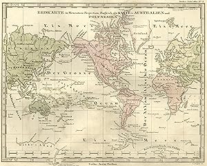
teilkolorierte gestochene Landkarte Erdkarte in Mercators Projection. Zugleich Karte v. Australien u. Polynesien Aus Stielers Hand-Atlas
Sprache: Deutsch
Verlag: Gotha, Justus Perthes, 1862
Anbieter: Allgäuer Online Antiquariat, Memmingen, DE, Deutschland
Verbandsmitglied: GIAQ
Verkäuferbewertung 5 von 5 Sternen

Kunst / Grafik / Poster
Blattgröße 22,5 x 30 cm (HxB). Zustand: Gut. C. Poppey sc. Ansichtsgröße 18,5 x 23 cm (HxB) Schönes Blatt. An den Rändern altersbed. leicht fleckig u. randrissig, im Druckbereich sauber. Für die Echtheit und Qualität der von uns angebotenen Stiche garantieren wir - Auf Wunsch, gegen Aufpreis mit Rahmen. Fragen Sie gerne bei uns an. Sprache: Deutsch Gewicht in Gramm: 300.
-

A. D. Stieler's Schul-Atlas über alle Theile der Erde und über das Weltgebäude. Inhalt: 32 illuminirte Karten in Kupferstich. 1. Planeten-System; 2. Die vorzüglichsten Sternbilder am nördlichen u. südl. Himmel. - Figuren zur mathematischen Geographie; 3. Östliche und westliche Halbkugel. - Theil von Australien; 4. Erdkarte in Mercator's Projection. Zeitunterschiede von Paris; 5. Europa (orographische Karte); 6. Europa (politische Übersicht); 7. Spanien und Portugal, 8. Frankreich; 9. Italien oder die Apenninische Halbinsel; 10. Die Britische Inseln; 11. Schweden, Norwegen und Dänemark; 12. Dänemark, Island u. Fär-Öer; - die Preussischen Elbherzogthümer Schleswig, Holsteim u. Lauenburg; 13. Deutschlan, Niederlande, Belgien und Schweiz (orogr
Verlag: Gotha. Justus Perthes Verlag., 1868
Anbieter: Antiquariat Hennwack, Berlin, Deutschland
Verkäuferbewertung 5 von 5 Sternen
Achtunvierzigste Auflage, verbessert und vermehrt. Gr-8vo. (Ca. 144 S). Goldgepr. OLn. Rücken gewellt; Einband und Rücken leicht berieben, fleckig und bestoßen; Ecken, Kanten und Kapitale etwas bestoßen und beschabt; vorderes und hinteres Gelenk gebrochen; einzelne Seiten lose, gelockert und stockfleckig; Schnitt unregelmäßig; sonst gut erhaltenes Exemplar. Sprache: deutsch.
-
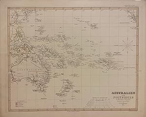
Australien und Polynesien in Mercators Projection
Verlag: Justus Perthes, Gotha, 1850
Anbieter: Argosy Book Store, ABAA, ILAB, New York, NY, USA
Verkäuferbewertung 5 von 5 Sternen
Map. Engraving with hand outline coloring. Image measures 12" x 15" Incredibly detailed map in German of the Pacific Ocean, including Australia, Southeast Asia, and New Zealand. Island groups are extensively labeled, and hand coloring is used throughout to indicate colonial holdings. This map appeared in the 1853 issue of Stieler's Hand Atlas. In very good condition with minor spotting, and toning to margins - not affecting the image. The publishing firm of Justus Perthes (1749-1816) was first established in 1785 and continued producing maps up through the beginning of the 21st century. Originally known for almanacs and yearbooks, the firm was nationalized by the German Democratic Republic in the 1950s and channeled its informational bent into the production of school atlases and wall maps. Along with important editors like Peterman, Stieler, Meyer and Spruner, the firm pioneered the Hand Atlas. The Perthes firm continues to publish atlases and maps even today. This map nicely conveys the rigor of their research and production.
-

Planiglob in Mercator's Projection. Zugleich als Karte v. Australien. Blatt No. IIb aus: Stieler's Schul-Atlas. Von Hand grenzkolorierter Kupferstich.
Sprache: Deutsch
Verlag: Perthes, Gotha, 1854
Anbieter: Magister Michalis, Internet-Antiquariat, Wielenbach, Deutschland
Verkäuferbewertung 5 von 5 Sternen
Karte
Kein Einband. Zustand: Gut. Blattgröße ca. 29x23,5 cm. Vierfarbig von Hand grenzkolorierte Karte. Leicht fleckig, vor allem am breiten weißen unbedruckten Rand. Original-Kolorierung sofort nach Druck, ohne spätere Nachzeichnungen oder Verschlimmbesserungen, Farben noch klar und leuchtend. +++ COPPER ENGRAVING WITH HAND COLORING in outline when published.+++ Aus Nichtraucherhaushalt. +++ Mehr Infos gerne über die Schaltfläche 'Frage an den Anbieter'.
-

Australien nach Krusenster u. A. in Mercators Projection entworfen u. gez. V. Ad. St. 1826
Verlag: Artist: Stülpnagel von L :, 1826
Anbieter: Antique Sommer& Sapunaru KG, München, Deutschland
Verkäuferbewertung 4 von 5 Sternen
Technic: Steel engraving, colorit: original colored, condition: Perfect condition, size (in cm): 30,5 x 38,5 cm, Map shows the Pacific Ocean with part of Asia, Southeast Asia, Japan, Australia, New Zealand and California.
-
Stahlstich- Karte, v. Poppey b. J. Perthes, "Erdkarte in Mercators Projection. Zugleich als Karte v. Australien und Polynesien".
Sprache: Deutsch
Anbieter: Antiquariat Clemens Paulusch GmbH, Berlin, Deutschland
Verkäuferbewertung 5 von 5 Sternen
Karte
mit altem Flächenkolorit, nach 1856, 18 x 23,5 Mit Amerika im Mittelpunkt.
-

Australien und Polynesien in Mercators Projection.
Erscheinungsdatum: 1853
Anbieter: Geographicus Rare Antique Maps, Brooklyn, NY, USA
Verbandsmitglied: ABAA ESA ILAB
Verkäuferbewertung 4 von 5 Sternen
Karte
Very Good. Original centerfold. Blank on verso. Size 16.5 x 13.5 Inches. A fascinating example of the 1853 Perthes map of Australia and Polynesia. This map covers from Southeast Asia eastward as far as the Gulf of California, and from Japan Southwards to include all of Australia, Tasmania, and New Zealand. This map corrects many of the cartographic errors of the previous century and consequently most coastlines accurately rendered. Inland though, much remains confused and only tenuously explored. Vast stretches of unmapped territory and speculative cartography fill central Australia, New Zealand and Papua New Guinea. Political and regional borders are highlighted in outline color. Unlike other cartographic publishers of the period, the Justus Perthes firm did not transition to lithographic printing techniques. Instead, all of their maps are copper plate engravings and hence offer a level of character and depth of detail impossible to find in lithography or wax-process engraving. All text is in German. Designed and drawn by Friedrich von Stülpnagel and issued as plate no. 50a in the 1854 edition of Stieler's Hand-Atlas .
-

Australien Nach Mercators Projection.
Verlag: L. Hess, 1816
Anbieter: Antiquariaat Dat Narrenschip, Middelburg, Niederlande
Verkäuferbewertung 5 von 5 Sternen
Karte
No Binding. Zustand: Good. Antique map of Australia, New Zealand and the small islands in the Pacific. Title bottom right. Backside blank. Hand colored copper engraving by L. Hess. Published in Gotha in 1816. Cartographer: Christian Gottlieb Theophit Reichard. Evenly slightly spotted in the margins. Dimensions (image): 28 x 34 cm.
-

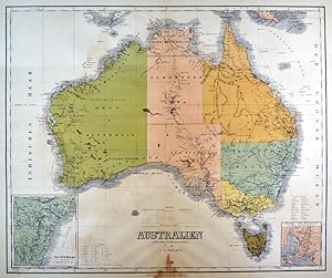
Stahlstich- Karte, v. C.F. Weiland, vervollständigt v. H. Kiepert, "Australien in Mercators Projection entworfen.".
Sprache: Deutsch
Anbieter: Antiquariat Clemens Paulusch GmbH, Berlin, Deutschland
Verkäuferbewertung 5 von 5 Sternen
Karte
mit altem Grenzkolorit, 1875, 47 x 57,5 2 kleine Nebenkarten ( with Insetmaps ) v. Neu Süd Wales und Colonie Süd - Australia.
-

'Australien nach Krusenstern, Flinders, Freycinet, Oxley King, Sturt und Mitchell in Mercators Projection entworfen und gezeichnet von C.F. Weiland. - Weimar Im Verlage des Geograph. Instituts. 1840.':.
Sprache: Deutsch
Anbieter: Antiquariat Norbert Haas, Bedburg-Hau, Deutschland
Verkäuferbewertung 5 von 5 Sternen
Karte
altkolorierter Kupferstich mit Bordüre v. Carl Ferdinand Weiland b. Geographisches Institut in Weimar, dat. 1841, 44 x 62 Tooley, The Mapping of Australia, page 165, 1335. - Zeigt das Polynesien zwischen Australien, Neuseeland (New Zealand) und Kalifornien (California). - Unten links Titel. - Am unteren Rand 3 Insetkarten von der Südwestspitze Australiens, Neu-Süd-Wales und van Diemens Land.
-
AUSTRALIEN. - Karte. "Australien in Mercators Projection". Gesamtkarte mit "Van Diemen's Insel". Mit zwei Nebenkarten.
Anbieter: Peter Bierl Buch- & Kunstantiquariat Inh.: Andrea Bierl, Eurasburg, Deutschland
Verkäuferbewertung 4 von 5 Sternen
Kunst / Grafik / Poster
Farblithographie nach Weiland, Weimar im Geograph. Institut, 1885, 48 x 57,5 cm. Espenhorst, PP 1.1.6. - Aus: Heinrich Kiepert's "Grosser Handatlas" (49. Ausgabe, Auflage 1885). - Gedruckt in ca. 7 verschiedenen Flächenfarben. Die Nebenkarten zeigen: "Neu Süd Wales" und "Colonie Süd-Australia". - Im Mittelbug unten ein Wasserrand.
-
AUSTRALIEN. - Karte. "Australien in Mercators Projection". Gesamtkarte mit "Van Diemen's Insel". Mit zwei Nebenkarten.
Anbieter: Peter Bierl Buch- & Kunstantiquariat Inh.: Andrea Bierl, Eurasburg, Deutschland
Verkäuferbewertung 5 von 5 Sternen
Kunst / Grafik / Poster
Grenzkol. Kupferstich nach Weiland und Kiepert, Weimar im Geograph. Institut, 1872, 47,5 x 57 cm. Espenhorst, PP 1.1.6. - Aus: Heinrich Kiepert's "Grosser Hand-Atlas" (43. Ausgabe, Auflage 1872). - Gewann 1871 die einzige Goldmedaille auf dem Geographenkongreß in Antwerpen (PP, S. 111). - Die Nebenkarten zeigen: "Neu Süd Wales" und "Colonie Süd-Australia". - Im breiten Rand leicht fleckig.
-
AUSTRALIEN. - Karte. "Australien in Mercators Projection". Gesamtkarte mit "Van Diemen's Insel". Mit zwei Nebenkarten.
Anbieter: Peter Bierl Buch- & Kunstantiquariat Inh.: Andrea Bierl, Eurasburg, Deutschland
Verkäuferbewertung 5 von 5 Sternen
Kunst / Grafik / Poster
Grenzkol. Kupferstich nach Weiland und Kiepert, Weimar im Geograph. Institut, 1872, 47,5 x 57 cm. Espenhorst, PP 1.1.6. - Aus: Heinrich Kiepert's "Grosser Hand-Atlas" (43. Ausgabe, Auflage 1872). - Gewann 1871 die einzige Goldmedaille auf dem Geographenkongreß in Antwerpen (PP, S. 111). - Die Nebenkarten zeigen: "Neu Süd Wales" und "Colonie Süd-Australia".


