Gesamtpreis (1 Artikel Artikel):
Versandziel:

atlas geographus compleat system geography (6 Ergebnisse)
Direkt zu den wichtigsten Suchergebnissen
Suchfilter
Produktart
- Alle Product Types
- Bücher (4)
- Magazine & Zeitschriften (Keine weiteren Ergebnisse entsprechen dieser Verfeinerung)
- Comics (Keine weiteren Ergebnisse entsprechen dieser Verfeinerung)
- Noten (Keine weiteren Ergebnisse entsprechen dieser Verfeinerung)
- Kunst, Grafik & Poster (1)
- Fotografien (Keine weiteren Ergebnisse entsprechen dieser Verfeinerung)
- Karten (1)
- Manuskripte & Papierantiquitäten (Keine weiteren Ergebnisse entsprechen dieser Verfeinerung)
Zustand Mehr dazu
- Neu (2)
- Wie Neu, Sehr Gut oder Gut Bis Sehr Gut (Keine weiteren Ergebnisse entsprechen dieser Verfeinerung)
- Gut oder Befriedigend (1)
- Ausreichend oder Schlecht (Keine weiteren Ergebnisse entsprechen dieser Verfeinerung)
- Wie beschrieben (3)
Einband
Weitere Eigenschaften
- Erstausgabe (1)
- Signiert (Keine weiteren Ergebnisse entsprechen dieser Verfeinerung)
- Schutzumschlag (Keine weiteren Ergebnisse entsprechen dieser Verfeinerung)
- Angebotsfoto (5)
Sprache (2)
Preis
- Beliebiger Preis
- Weniger als EUR 20 (Keine weiteren Ergebnisse entsprechen dieser Verfeinerung)
- EUR 20 bis EUR 45 (Keine weiteren Ergebnisse entsprechen dieser Verfeinerung)
- Mehr als EUR 45
Gratisversand
- Kostenloser Versand nach USA (Keine weiteren Ergebnisse entsprechen dieser Verfeinerung)
Land des Verkäufers
Verkäuferbewertung
-

Atlas geographus : or, a compleat system of geography, ancient and modern. Containing what is of most use in Bleau, Verenius, Cellarius, Cluverius, Baudrand, Brietius, Sanson Volume 4 of 5
Verlag: Gale Ecco, Print Editions Sep 2010, 2010
ISBN 10: 0699111781 ISBN 13: 9780699111782
Sprache: Englisch
Anbieter: AHA-BUCH GmbH, Einbeck, Deutschland
Verkäuferbewertung 5 von 5 Sternen

Taschenbuch. Zustand: Neu. Neuware.
-
Atlas Geographus: or, a Compleat System of Geography. Extract
Verlag: John & Eliz. Nutt, London, 1716
Anbieter: Antipodean Books, Maps & Prints, ABAA, Garrison, NY, USA
Verbandsmitglied: ABAA ANZAAB ESA ILAB
Verkäuferbewertung 5 von 5 Sternen
Erstausgabe
Hardcover. Zustand: Very good condition. First printing. The section on "Terra Australis" from Moll's 5 volume work, including the title page for Vol V, iv, 22pp, with the folding Moll map of Australia entitled "New Guinea, New Britain, and New Holland &c.", one of the earliest English maps devoted to the Australian continent (Tooley p 122, no 90). Includes The entire "Terra Australis Incognita" part, a most interesting compilation from various sources, the Australian information "according to Luyts". This includes Diemens Land, New Zealand, Carpentaria, New Guinea, and finally New Holland. Includes Australian locations named Carpentary, Country of Diemens, The Kingdom of Beach, Lucat & Maletur, New Holland in Six Parts viz Country of Lewennen, Edels, Nuits, Concords, De Wit's Land and Arnent. Outsize 8vo, (iv), 1-22pp. Text with a crescent shaped waterstain, which has not penetrated the map. Sewed into a modern full dark brown calf binding with gilt title on spine "America 1717". Subtitle - With the discoveries and improvements of the best Spanish, Dutch, French and English authors and travelers, ancient and modern, to this time; with about 30 new maps, cuts, Sansons tables, &c. as may be seen in the Catalogues thereof annex'd to the Index. The maps done by Herman Moll, geographer, in which are all the latest observations. Europe is two volumes, Asia the third, Africa the fourth, and this the fifth. Vol. V. To which is added, a Catalogue of the maps, cuts, and Sansons tables in all the five volumes, and a description of Bosnia, by omission left out in Europe. In the Savoy: Printed by Eliz. Nutt, for John Nicholson at the King's Arms in Little Britain: and sold by John Morphew near Stationers-Hall . MDCCXVII. Where may be had Numb. 1, to 17. (Price 1 s. each.). Printed in double columns./ Apparently issued originally in monthly numbers. OCLC: 3923611.
-

Atlas geographus: or, a compleat system of geography, ancient and modern Volume 4 1714
Verlag: Facsimile Publisher
ISBN 10: 9361586327 ISBN 13: 9789361586323
Anbieter: Majestic Books, Hounslow, Vereinigtes Königreich
Verkäuferbewertung 4 von 5 Sternen

EUR 55,43
EUR 7,44 shipping
Ships from Vereinigtes Königreich to USAAnzahl: 4 verfügbar
In den WarenkorbZustand: New. pp. 840.
-
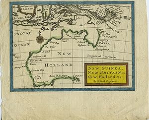
Map of Australia entitled "New Guinea, New Britain, and New Holland &c." from the Atlas Geographus: or, a Compleat System of Geography, (Ancient and Modern) for America. Containing What is of most Use in Bleau, Varenius, Cellarius, Cluverius, Luyts, Baudrand, Sanson, the Royal Commentaries of Peru, &c.
Verlag: Eliz. Nutt for John Nichoson, London, 1716
Anbieter: Antipodean Books, Maps & Prints, ABAA, Garrison, NY, USA
Verbandsmitglied: ABAA ANZAAB ESA ILAB
Verkäuferbewertung 5 von 5 Sternen
This Moll map of Australia entitled "New Guinea, New Britain, and New Holland &c.", is one of the earliest English maps devoted to the Australian continent (Tooley p 122, no 90). The map shows Australian locations named Carpentaria, Dimens Land, De Wits Land, Eendracht Land, Edels Land, Lewins Land, and Land of P. Nuys. At the top of the map can be seen N. Guinea and the Sunda Islands. Image size 7 x 5". With later outline color and title block in yellow with red border. Trimmed close at the top (leaving 1/8" margin) and with 1 1/2" bottom margin. One original fold line, very good.
-
Atlas Geographus: or, a Compleat System of Geography, ancient and modern. containing what is of most use in Bleau, Varenius, Cellarius, Cluverius, Baudrand, Brietius, Sanson, &c. with the discoveries and improvements of the best modern authors to this time. illustrated with about 100 new maps, done from the latest observations, by Herman Moll, geographer. .
Verlag: 1711-1717., 1711
Anbieter: Maggs Bros. Ltd ABA, ILAB, PBFA, London, Vereinigtes Königreich
Verbandsmitglied: ABA ILAB PBFA
Verkäuferbewertung 5 von 5 Sternen
Karte
EUR 11.791,45
EUR 30,91 shipping
Ships from Vereinigtes Königreich to USAAnzahl: 1 verfügbar
In den WarenkorbQuarto (220 x 165 mm); five volumes. Vol. I: eighteen map-sheets (of twentyone) and six plates; vol. II: twenty-two (of twenty-three) maps and two plates; vol. III: fifteen (of sixteen) maps and two plates; vol. IV: eleven (of twelve) maps; vol. V: twenty (of twenty-one) map sheets. Contemporary calf, panelled in blind, red morocco label to vol. IV (other labels missing). Spines worn. London : John Nutt [for John Nicholson], The Atlas Geographus was an important English world geography, issued as a partwork between 1708 and 1717, and then assembled in five volumes, dated from 1711 to 1717: Europe in two volumes; volume III Asia, IV Africa and V Americas. While authorship is generally attributed to Herman Moll, he was probably only responsible for supplying the new maps required. Part 1 was advertised on 18th June, 1708 as ?This Day is Publish?d .?; subsequent parts, priced 1s., were promised monthly, but the final part was only advertised on 2nd March, 1717. Compared with Shirley?s collation, this set lacks 4 (World), 5 (Europe), 36 (Spain and Portugal), 72 (Africa) and 82 (New Guinea). 63 is replaced by Moll?s map of Persia and 79 by Moll?s map of Guinea. There are additional maps of ?Aegyptus and Cyrene?, ?Mauritania ?? and the ?Sea Coast from Streights of Magellan ?? The complete set is particularly rare, and even individual volumes are very scarce. Reference: Shirley, T.Moll-3a: calling for 100 sheets (numbered to 101, but 86 omitted), the collation differing (as is not uncommon).
-
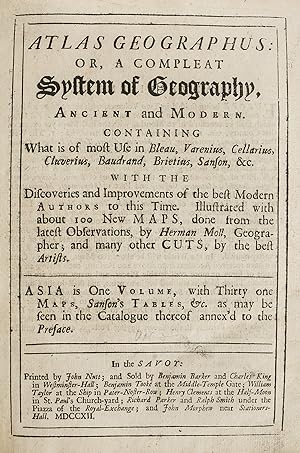
Atlas Geographus: or, a Compleat System of Geography, ancient and modern. containing what is of most use in Bleau, Varenius, Cellarius, Cluverius, Baudrand, Brietius, Sanson, &c. with the discoveries and improvements of the best modern authors to this time. illustrated with about 100 new maps, done from the latest observations, by Herman Moll, geographer; and many other cuts, . Asia is one volume, with thirty-one maps, Sanson's Tables, &c. .
Erscheinungsdatum: 1712
Anbieter: Maggs Bros. Ltd ABA, ILAB, PBFA, London, Vereinigtes Königreich
Verbandsmitglied: ABA ILAB PBFA
Verkäuferbewertung 5 von 5 Sternen
Kunst / Grafik / Poster
EUR 3.537,43
EUR 30,91 shipping
Ships from Vereinigtes Königreich to USAAnzahl: 1 verfügbar
In den WarenkorbQuarto (220 x 165 mm); [viii], *8, 851pp, eighteen (of nineteen) mostly doublepage or folding engraved maps and plates, lacking the modern map of Asia. Inked ownership inscription dated 1953. Contemporary calf, panelled in blind, remnants of black morocco label to spine. Corners bumped, some wear to extremities of spine. London : John Nutt [for John Nicholson], The Atlas Geographus was an important English geography, issued as a part-work between 1708 and 1717, subsequently assembled into five volumes, dated 1711 to 1717, illustrated with maps, plates and text illustrations. This is the third volume, devoted to Asia; textually it is complete in itself, assembled from 15 parts. The maps include separate delineations of Arabia, Persia (both classical and modern), China, the East Indies and Japan. Publication of the completed volume was announced in the Post Boy for 8th-10th April 1712, but the Daily Courant for 14th April has a fuller notice, giving the price in quires (unbound) as 15s. or 16s. with the maps coloured. The complete set is particularly rare, and even individual volumes are very scarce. References: Shirley, T.Moll-3a, vol. 3, maps 53-71, map 63 correctly replaced by a modern map of Persia.