

Gesamtpreis (1 Artikel Artikel):
Versandziel:

antique map holstein germany (5 Ergebnisse)
Direkt zu den wichtigsten Suchergebnissen
Suchfilter
Produktart
- Alle Product Types
- Bücher (3)
- Magazine & Zeitschriften (Keine weiteren Ergebnisse entsprechen dieser Verfeinerung)
- Comics (Keine weiteren Ergebnisse entsprechen dieser Verfeinerung)
- Noten (Keine weiteren Ergebnisse entsprechen dieser Verfeinerung)
- Kunst, Grafik & Poster (1)
- Fotografien (Keine weiteren Ergebnisse entsprechen dieser Verfeinerung)
- Karten (1)
- Manuskripte & Papierantiquitäten (Keine weiteren Ergebnisse entsprechen dieser Verfeinerung)
Zustand Mehr dazu
- Neu (Keine weiteren Ergebnisse entsprechen dieser Verfeinerung)
- Wie Neu, Sehr Gut oder Gut Bis Sehr Gut (Keine weiteren Ergebnisse entsprechen dieser Verfeinerung)
- Gut oder Befriedigend (2)
- Ausreichend oder Schlecht (Keine weiteren Ergebnisse entsprechen dieser Verfeinerung)
- Wie beschrieben (3)
Einband
- alle Einbände
- Hardcover (Keine weiteren Ergebnisse entsprechen dieser Verfeinerung)
- Softcover (Keine weiteren Ergebnisse entsprechen dieser Verfeinerung)
Weitere Eigenschaften
- Erstausgabe (Keine weiteren Ergebnisse entsprechen dieser Verfeinerung)
- Signiert (Keine weiteren Ergebnisse entsprechen dieser Verfeinerung)
- Schutzumschlag (Keine weiteren Ergebnisse entsprechen dieser Verfeinerung)
- Angebotsfoto (5)
Sprache (2)
Gratisversand
- Kostenloser Versand nach USA (Keine weiteren Ergebnisse entsprechen dieser Verfeinerung)
Land des Verkäufers
Verkäuferbewertung
-
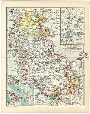
Antique Map-SCHLESWIG HOLSTEIN-GERMANY-Meyers-1895
Erscheinungsdatum: 1895
Anbieter: Pictura Prints, Art & Books, Overasselt, Niederlande
Verkäuferbewertung 5 von 5 Sternen

Kunst / Grafik / Poster
No Binding. Zustand: Very Good. No Jacket. We carry this map in different editions. Please enquire if you are iterested in a specific ed. Original colour lithographs. on paper. Size in cm: The overall size is ca. 24 x 30 cm. The image size is ca. 22 x 27 cm. Size in inch: The overall size is ca. 9.4 x 11.8 inch. The image size is ca. 8.7 x 10.6 inch.Map: ''Schleswig-Holstein.'' (Map of Schleswig Holstein, Germany.) This attractive original old antique print / plate / map originates from 1885-1907 editions of a famous German encyclopedia: 'Meyers grosses Konversations-Lexikon.', published in Leipzig and Vienna. Meyers Konversations-Lexikon was a major German encyclopedia that existed in various editions from 1839 until 1984, when it merged with the Brockhaus encyclopedia. Several of the plates were also used in Dutch Encyclopedia's like Winkler Prins. Artists and Engravers: The original founder and publisher who initiated this famous encyclopedia was Joseph Meyer (1796-1856, Hildburghausen, Germany).Condition: Very Good. Original middle fold, as issued. General age-related toning and occasional light stains from handling. Please study image carefully.Keywords: ANTIQUE MAP-SCHLESWIG HOLSTEIN-GERMANY-MEYERS(PCOMAN) A176-34.
-

"The North West Part of Germany" by Herman Moll, often found in editions around 1728 (or published in his Modern History series), is an antique map detailing the Northwestern region of the Holy Roman Empire, including parts of modern-day Westphalia, Lower Saxony, and the Netherlands. Key Features of the 1728 Region/Map: Germany, anno 1728, antique map by Moll Hermann, size of the printed area: 25 x 19 cm. Territories: The map covers the dominions of the Arch: and El: of Cologne, Westphalia (Juliers, Cleves), Munster, Osnaburgh, Holstein, Bremen, Hanover, Lunenburgh, Brunswick, and Hesse-Cassel.
Sprache: Englisch
Erscheinungsdatum: 1728
Anbieter: Hammelburger Antiquariat, Hammelburg, Deutschland
Verkäuferbewertung 5 von 5 Sternen
Karte
Zustand: Befriedigend. "The North West Part of Germany" by Herman Moll, often found in editions around 1728 (or published in his Modern History series), is an antique map detailing the Northwestern region of the Holy Roman Empire, including parts of modern-day Westphalia, Lower Saxony, and the Netherlands. Key Features of the 1728 Region/Map: Germany, anno 1728, antique map by Moll Hermann, size of the printed area: 25 x 19 cm. Territories: The map covers the dominions of the Arch: and El: of Cologne, Westphalia (Juliers, Cleves), Munster, Osnaburgh, Holstein, Bremen, Hanover, Lunenburgh, Brunswick, and Hesse-Cassel. Geographical Scope: It depicts the Dutch Republic (United Provinces) on the left, extending through the Westphalian region to Lower Saxony and parts of Saxony/Franconia to the east. Details: It highlights cities, forts, and districts, often including detailed, artistic title cartouches in the style of 18th-century English cartography. Cartographer: Herman Moll (c. 1654-1732) was a London-based cartographer and engraver known for maps featuring significant artistic embellishments. These maps were often produced for Atlas Geographus or Modern History, reflecting the British interest in the European power dynamics of that period.
-

Antique Map of Holstein, Germany
Anbieter: Bartele Gallery - The Netherlands, Langweer, FRL, Niederlande
Verkäuferbewertung 5 von 5 Sternen
Antique map titled 'Holsatia Ducatus'. Original old map of Holstein, Germany. By Petrus Kaerius, published circa 1650. Pieter van den Keere (Latin: Petrus Kaerius 1571 ? circa 1646) was a Flemish engraver, publisher and globe maker.
-

Antique Map of Northern Germany, Including Schleswig-Holstein and Hamburg
Anbieter: Bartele Gallery - The Netherlands, Langweer, FRL, Niederlande
Verkäuferbewertung 5 von 5 Sternen
Antique map titled 'Basse Partie de la Basse Saxe ou sont les Duchés de Sleswick, Holsace, Meckelenbourg et Lauvenbourg (.)'. Original old map of northern Germany, including Schleswig-Holstein, Hamburg, and Mecklenburg-Vorpommern. Published by N. Sanson, 1657. Nicholas Sanson (1600-1667) is considered the father of French cartography in its golden age from the mid-seventeenth century to the mid-eighteenth. Over the course of his career he produced over 300 maps; they are known for their clean style and extensive research. Sanson was largely responsible for beginning the shift of cartographic production and excellence from Amsterdam to Paris in the later-seventeenth century.
-

Large Original Antique Map of the Dutchy of Holstein, Germany, ca.1840
Anbieter: Bartele Gallery - The Netherlands, Langweer, FRL, Niederlande
Verkäuferbewertung 5 von 5 Sternen
Antique map titled 'A Map of the Dutchy of Holstein, with the Territories of the Imperial Towns Hamburg & Lubek, Also The Bishoprick of Eutin, Laid down from Fischer's Map (.)'. Scarce regional map of Northern Germany, focused on the Duchy of Holstein and towns of Hamburg and Lubeck. Beautifully engraved to show fortified towns, principal towns, market towns, castles, noblemen's seats, farms, villages, windmills, dykes and topography. Source unknown, to be determined. Artists and Engravers: James Wyld (1812?1887) was a British geographer and map-seller, best known for Wyld's Great Globe. He was successor to William Faden, one of the luminaries of late eighteenth century publishing in England. Wyld maintained the high standard of graphic and factual excellence that had been established by his predecessor and his maps are among the finest published in the early nineteenth century.
